
Defined in various ways, risk is an assessment of the potential for harm based on the probability of occurrence, level of intensity, and other parameters that characterize an event and its consequences. Risk can thus be understood as the combination of an impending event’s likelihood to happen (hazard) and facing its consequences (problem & vulnerability) (Wisner et al., 2004).
Vulnerability is defined as the conditions determined by physical, economic, social, and environmental factors or processes that increase the susceptibility of a community to the effects of hazards (Birkmann, 2006).
Landslides represent a significant natural hazard in many urban regions, particularly where complex geological, climatic, and anthropogenic factors intersect. In Algeria, Constantine is one of the cities most exposed to this risk due to its fragile geological structure, rapid urbanization, and variable climate. Although some regional studies exist regarding landslide susceptibility, there has yet to be an integrated multi-factor evaluation of urban-scale analysis for comprehensive regional vulnerability assessment. Given the strategic significance landslides hold from both humanitarian and financial perspectives, bolstering risk prevention while simultaneously decreasing vulnerabilities at both a regional and local level becomes essential. This proactive approach aids in estimating danger while assessing vulnerability (Glade, 2003; Fell et al., 2008).
This study proposes a new approach for assessing landslide vulnerability in Constantine using a multi-criteria evaluation method integrated into a GIS. Six key parameters – topography, geology, hydrology, rainfall, seismicity, and land use – were weighted based on expert surveys and mapped to generate a composite vulnerability index (Alcántara-Ayala, 2002).
The resulting vulnerability map categorizes Constantine into three vulnerability levels (high, medium, low). The areas with the highest vulnerability correspond closely with known zones of historical instability. A comparative validation with the reference ARCADIS-Simecsol study shows a 97% spatial match, confirming the reliability of the proposed model.
The study of the various indices of landslide vulnerability, including geology, hydrology, slope, and climatology, allows us to determine the influence of each factor in the study of instability in the city of Constantine (Bourenane et al., 2015; Bourenane et al., 2016; Abdi et al., 2021).
Our contribution is to use a new multi-criteria approach to produce a detailed map of landslide vulnerability in the city of Constantine using a GIS, as understanding the contribution of each factor is essential to assess the phenomenon accurately (van Westen et al., 2008). By identifying spatial patterns of vulnerability (Papathoma-Köhle et al., 2017), this approach provides valuable guidance for decision-makers in prioritizing interventions and planning future development.
The first stage of any research is to collect information about the study area in a structured way. This begins with an analysis of the natural processes associated with the physical environment that are responsible for the risk, followed by a characterization of the lithology and identification of signs of instability on the slopes (Guzzetti et al., 2005; van Westen et al., 2006).
Constantine is Algeria’s third largest city, located in the east of the country between 36.24° latitude and 6.60° longitude, about 437 km from Algiers (Fig. 1). It covers an area of 2,297.2 km2 and in the last census in 2008, it had a population of 921,893, which is now estimated at around 1.5 million (Office National de la Météorologie [ONM], 2024).
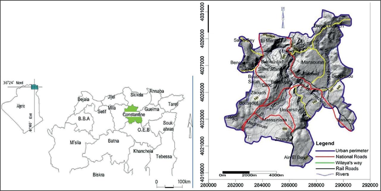
Geographical location of the city of Constantine
Source: own work based on Bourenane and Bouhadad (2021).
Causative factors – also referred to as conditioning or predictive variables – play a fundamental role in the initiation and propagation of landslides. These factors can be categorized into six main groups, each representing different dimensions of the natural and anthropogenic environment that influence slope stability (Guzzetti et al., 2005, 2007; van Westen et al., 2008; Arif et al., 2023).
Geomorphological factors
These include terrain elevation (hypsometry) and slope angle, which directly control the gravitational forces acting on a slope. Steep slopes increase the downslope component of gravity, thus enhancing landslide susceptibility (Yalcin, 2008). Slope curvature and aspect also influence soil moisture retention and solar radiation exposure (Taib et al., 2025).
Hydrological factor (drainage density)
High drainage density areas often experience rapid water flow, leading to slope undercutting and erosion. The proximity to drainage networks is frequently used in GIS models as a landslide trigger proxy (Saha et al., 2002; Lee & Pradhan, 2006).
Climatic factor (precipitation)
Rainfall is one of the most important external triggers for landslides, particularly in regions with intense or prolonged precipitation. Rainfall intensity and antecedent moisture conditions affect pore water pressure and slope saturation (Glade, 2003; Guzzetti et al., 2007).
Geological factors (lithological facies and fracturing)
Weak or weathered lithologies such as clay, marl, or shale are more susceptible to failure than consolidated rock types. Additionally, the degree of fracturing or faulting influences groundwater movement and slope weakening (Mezhoud & Benazzouz, 2018).
Seismic factor (seismic micro-zonation)
Ground shaking from seismic events can directly trigger landslides, especially in areas already predisposed by geological or geomorphological conditions. Micro-zonation maps are used to identify zones of amplified seismic risk (Chettah et al., 2024).
Anthropogenic factors (land use and human activity)
Deforestation, road cuts, urbanization, and slope modification for agriculture can dramatically alter natural slope stability. Human-induced changes are increasingly considered in landslide susceptibility studies, especially in expanding urban regions (Pradhan, 2010).
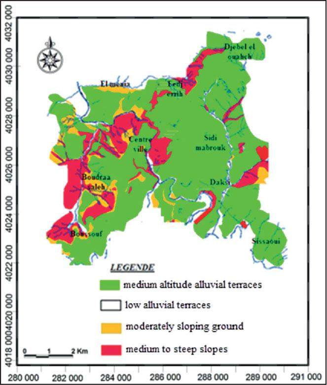
The city of Constantine is in the high eastern plains of the Tellian Atlas, at an average altitude of between 500 m and 800 m. Its topography is undulating, with flat areas bordered by steep slopes and marked differences in level. Its varied and contrasting topography includes deep gorges, plateaux, valleys, and hills surrounding the rocky outcrop, which forms the central core of the town (Mezhoud & Benazzouz, 2018).
According to the slope map (Fig. 2), the distribution of slopes shows that:
- –
More than half of the area studied has slopes between 10 and 30%.
- –
The steepest slopes, over 30%, are mainly found in the vicinity of rivers, forming their banks.
- –
The lowest slopes (0‒10%), which account for a large part of the PDAU, are found on the alluvial terraces of the Rhumel and Boumerzoug wadis and, to the north-west, on the rocky outcrop, and the Mansourah, Coudiat, and Salah Bey plateaux.
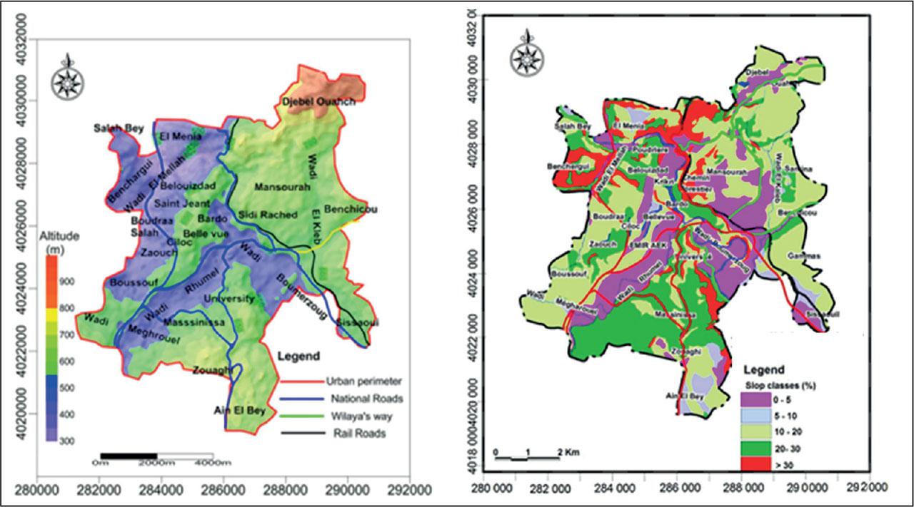
Altimetry and slope maps of the city of Constantine
Source: Bourenane et al. (2015).
The region of Constantine is characterized by a relatively dense hydrographic network (Fig. 3), with the city itself situated at the confluence of two main watercourses:
The Oued Boumerzoug, which flows north-south upstream and then north-west-south-east downstream, and the Oued Rhumel, whose direction varies throughout its course, crossing the Constantine gorges.
Intense erosion in the region has created numerous tributaries to these two ouadis. These include the Oued Athmania, Oued Seguen, Oued Ziad, and Oued Smendou, which flow into the Oued Rhumel, while the Oued El Klab, Oued Melah, Oued Berda, and Oued Hamimime flow into the Oued Boumerzoug.
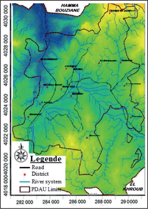
Constantine hydrographic network
Source: own work based on Mezhoud and Benazzouz (2018), Samy et al. (2019).
It is important to note that these watercourses generally have low flow rates and can even dry up completely during periods of intense heat. On the other hand, during the rainy season, intense rainfall often leads to flash floods that reach record levels and cause landslides along their banks.
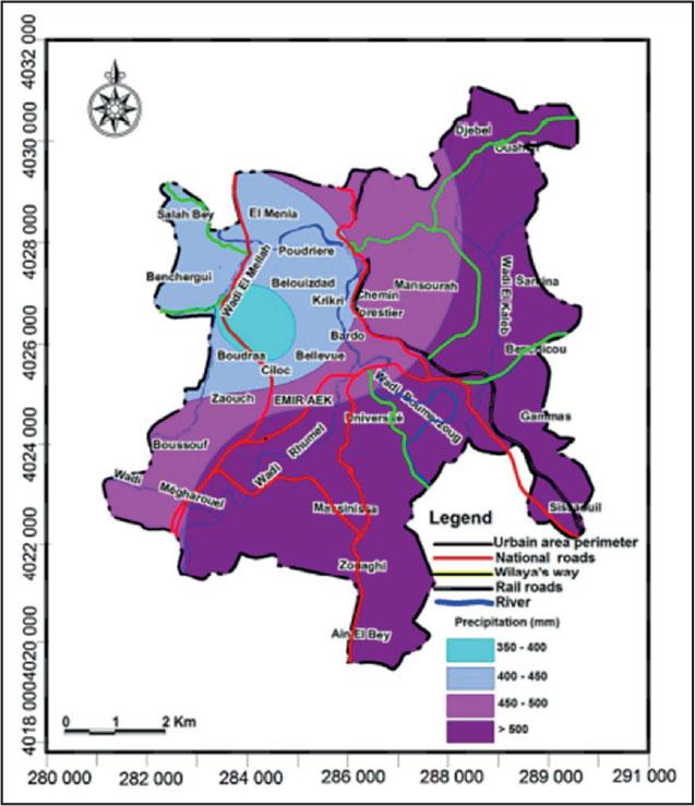
In the study, a recent rainfall series covering the period from 1 January 1975 to 31 December 2017, provided by the National Meteorological Office (ONM) in Aï n El Bey, was used for precipitation determination. The city of Constantine is in an area where annual rainfall varies between 400 mm and 800 mm (Fig. 4).
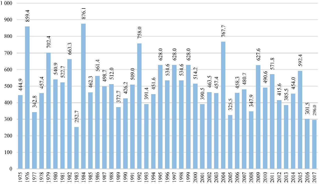
Precipitation in Constantine in 1975‒2017
Source: ONM (2024).
The geological framework of Constantine plays a critical role in assessing landslide risk, with lithological and structural characteristics serving as primary indicators. Based on the work of Coiffait (2012), the study area lacks Pliocene formations; instead, the lacustrine limestones of Ain El Bey and Mansourah have been reclassified as early Quaternary. These are distinguished by a sandy-conglomeratic base and thinner profiles compared to true Pliocene deposits.
The Quaternary formations are primarily composed of lacustrine limestones from the Mansourah, Ain El Bey, and Salah Bey plateaus, along with alluvial terraces from the Rhumel and Boumerzoug rivers (Fig. 5). These formations exhibit varied lithological sequences, including conglomerates, micritic and travertine-like limestones, and cemented sands, each contributing to slope stability characteristics.
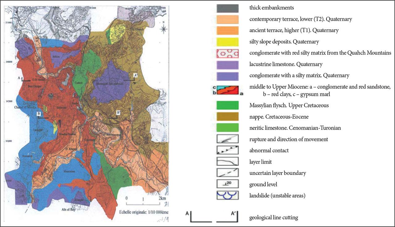
Constantine geomorphology
Source: Geological survey; Bougdal-Belhai; USTHB-FST-GAT-DUC Constantine (2002).
Three distinct alluvial terraces are identified:
The younger terrace, adjacent to rivers, is flood-prone due to its sandy-silt composition.
The intermediate terrace, used increasingly for development, shows moderate flood exposure.
The ancient terrace, elevated and composed of conglomerates, is less exposed but reflects tectonic uplift.
The stepped configuration of these terraces suggests significant Neogene tectonic activity, where differential uplift – not river incision – has shaped the landscape and influenced current geomorphological instability (Bouragba et al., 2023).
The seismic history of the Constantine region is essential for understanding local seismic hazards. Historical seismic data help identify potential earthquake sources and active fault zones. Key reference catalogs used in the analysis include works by Harbi (2001, 2003, 2007), Benouar (1994), Mokrane et al. (1994), and international databases such as those from the International Commission on Stratigraphy, as well as studies by Bezzeghoud et al. (1996).
The historical seismicity map was developed through a rigorous methodology involving the compilation and homogenization of various seismic catalogs using standardized magnitude and intensity scales. Major earthquakes, such as those of 1908, 1947, and 1985, serve as benchmarks in the regional seismic record.
Spatial analysis of epicenters reveals concentrated seismic activity along the Constantine–Guelma axis in the Tellian region, the Tébessa area of the Atlas Mountains, and the coastal corridor between Jijel and Skikda – highlighting these as zones of heightened seismic risk in northeastern Algeria.
Constantine has undergone significant demographic changes marked by rapid population growth and shifting urban dynamics. Between 1954 and 1966, the city experienced a peak annual growth rate of 9.6%, largely driven by rural migration and natural population increase following Algeria’s independence. Subsequent decades saw continued growth: from 240,000 inhabitants in 1966 to over 450,000 by 1987, fueled by industrial and service sector expansion.
However, from 1987 to 1998, the growth rate slowed to 0.6%, with urban sprawl shifting toward surrounding municipalities due to land shortages within the city. Between 1998 and 2008, Constantine saw a slight population decline, primarily due to outmigration from the urban core, degradation of old housing, and land scarcity.
Since 2008, the population trend has reversed, with growth reaching an estimated 475,510 by 2024, attributed to peripheral urbanization and new housing developments. Over the 1998–2024 period, the population increased by 7.2%.
Housing density remains uneven across the city’s districts, with high density in areas like Sidi Rached and significantly lower values in Kitouni, El Gammas, Les Mûriers, and the 5 July 1962 sector, reflecting variations in housing typology and urban planning.
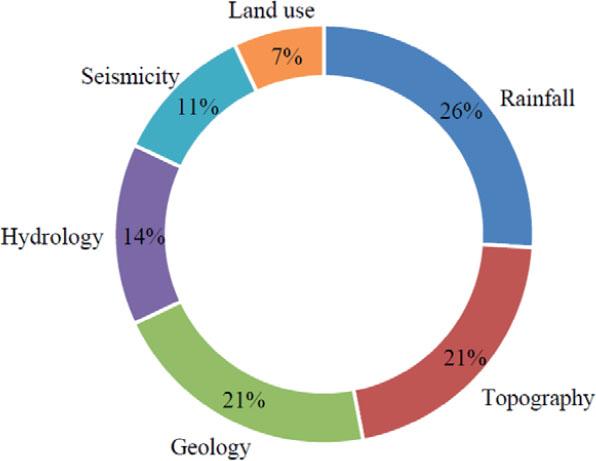
To identify the most critical factors influencing the vulnerability of the city of Constantine to landslides, a structured survey was conducted among members of the scientific community, including researchers, academics, and experts in geosciences and natural hazards. The objective of the survey was to prioritize six key parameters: topography, hydrology, rainfall, geology, seismicity, and land use (Ladjel et al., 2025).
The data collected from the survey were systematically analyzed to determine the relative importance given to each parameter by the respondents. The analysis provides valuable insights into experts’ perceptions of the key factors contributing to landslide vulnerability in Constantine. The results not only highlight the most influential parameters but also provide a basis for the development of targeted risk reduction strategies. The breakdown of the results is shown in Figure 6.
Hierarchy of the different factors influencing landslide vulnerability
Source: own work.
The results indicate that rainfall is perceived as the most significant factor in triggering landslides, accounting for 26% of responses. This outcome aligns with the understanding that precipitation, particularly when intense or prolonged, plays a critical triggering role by saturating the soil with water, thereby reducing its cohesion and increasing its instability.
The results indicate that rainfall is perceived as the most significant factor in triggering landslides, accounting for 26% of responses. This outcome aligns with the understanding that precipitation, particularly when intense or prolonged, plays a critical triggering role by saturating the soil with water, thereby reducing its cohesion and increasing its instability.
Topography and geology follow closely, each contributing 21%. Topography, through the slope of the land, directly impacts the severity of mass movements, while the geological composition of soils and rock formations dictates their mechanical strength. As such, these two parameters are structural in nature and determine the terrain’s susceptibility to movement. Hydrology, with 14%, occupies an intermediate position. It is concerned with the presence and behavior of both surface and groundwater, which can weaken the soil at various depths. While its influence is often indirect, it plays a pivotal role, especially in areas with high infiltration rates. Seismicity (11%) and land use (7%) are considered less influential by the respondents. While seismic activity can indeed trigger landslides under specific geological conditions, its effect is typically localized, linked to particular events. Land use, although seen as a secondary factor, can exacerbate vulnerability through soil overload or changes in vegetation cover.
In this approach, we will produce a predictive map of landslide risk in the city of Constantine, highlighting the main thoroughfares and the most vulnerable areas. This study will be refined by using the vulnerability index method.
The methodology consists of separately mapping the natural and anthropogenic factors that serve as indicators of vulnerability. For each map, we have assigned a critical index on a numerical scale based on its importance, as determined in advance by our survey. By summing these indices, we obtain the map of the total index, which provides a minimum and maximum range of risks that are likely to cause harm or damage to the area studied.
The topography of the site is represented by the slope index (SLI). This index allows the creation of a slope factor map (Fig. 7), which is made using the topographic map of the city of Constantine. The slope classes of the terrain slope parameter are shown in Table 1.
Slopes in Constantine
Source: own work.
Classification according to the slope of the land parameter
| Index (SLI1) = 1 | Index (SLI2) = 2 | Index (SLI3) = 3 |
|---|---|---|
| slope <15% | slope between 15% and 45% | slope >45% |
| low risk | medium risk | high risk |
| green | orange | red |
Source: own work.
The hydrology of the site is represented by the hydrology index (HI). This index allows the creation of a hydrology factor map, which is made using the topographic map and the map of watercourses of the city of Constantine. This index is based on the proximity or distance of the wadis and watercourses, as areas near watercourses are more vulnerable to landslides and erosion effects. The classes of this “terrain hydrology” index are shown in Table 2. Distance from the river indicates the influence of the river on slope stability (Fig. 8).
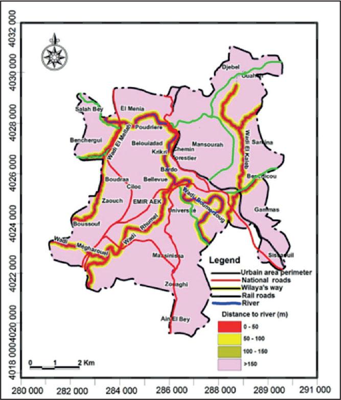
River influence on slope stability
Source: Bourenane et al. (2015).
Classification according to the distance from watercourses parameter
| Index (HI1) = 1 | Index (HI2) = 2 | Index (HI3) = 3 |
|---|---|---|
| distance from watercourses more than 100 m | distance from watercourses between 50‒100 m | distance from watercourses less than 50 m |
| low risk | medium risk | high risk |
| green | orange | red |
Source: own work.
The climatic behavior of the studied region and the meteorological determinism show intense, time-concentrated rainfall, but in variable quantities and occurrences (Table 3). A commonly accepted danger and alert threshold by the international community is 50 mm per 24 hours (Guzzetti et al., 2007). The most at-risk rainy periods always require particular monitoring. Figure 9 shows the spatial distribution of the average annual rainfall over a 32-year period in the city of Constantine.
Spatial distribution of the average annual rainfall in 1980–2012 in the city of Constantine
Source: Bourenane et al. (2014).
Classification according to the rainfall parameter
| Index (RI1) = 1 | Index (RI2) = 2 | Index (RI3) = 3 |
|---|---|---|
| rainfall intensity < 50 mm | rainfall intensity between 50 and 100 mm / 24 hours | rainfall intensity > 100 mm / 24 hours |
| low risk | medium risk | high risk |
| green | orange | red |
Source: own work.
Moderate but persistent rainfall proves to be more dangerous for the stability of a slope than short-duration heavy showers. The former promotes increased infiltration and deep soil saturation, leading to changes in soil properties and encouraging landslides, while the latter is mostly evacuated through surface runoff, having little effect on the water content of deep soil layers but causing significant erosion along the banks of the ouadis.
According to data obtained from the National Meteorological Office, two seasons dominate:
From January to March, it corresponds to winter and early spring.
From October to December, coinciding with autumn and early winter. However, two exceptional years show a concentration of rainfall in spring and early summer, specifically between April and June.
The soil type is represented by the soil index (SI) (Table 4). This index enables the development of a soil factor map (Fig. 10), as soil quality plays a crucial role in slope stability. Consequently, bedrock is preferred over artificial fill or loose, unconsolidated soil.
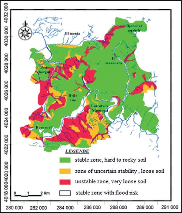
Types of soil in Constantine
Source: own work.
Classification according to soil type
| Degree of risk of indices (SI) | SI1 = 1 | SI2 = 2 | SI3 = 3 |
|---|---|---|---|
| Ground instability | low | medium | high |
| Soil quality for construction | good | medium | bad |
| Color | green | orange | red |
Source: own work.
Considering habitat density as a factor influencing the frequency of risk, the construction density index (CDI) has been assigned by category, as shown in Table 5 and Figure 11.
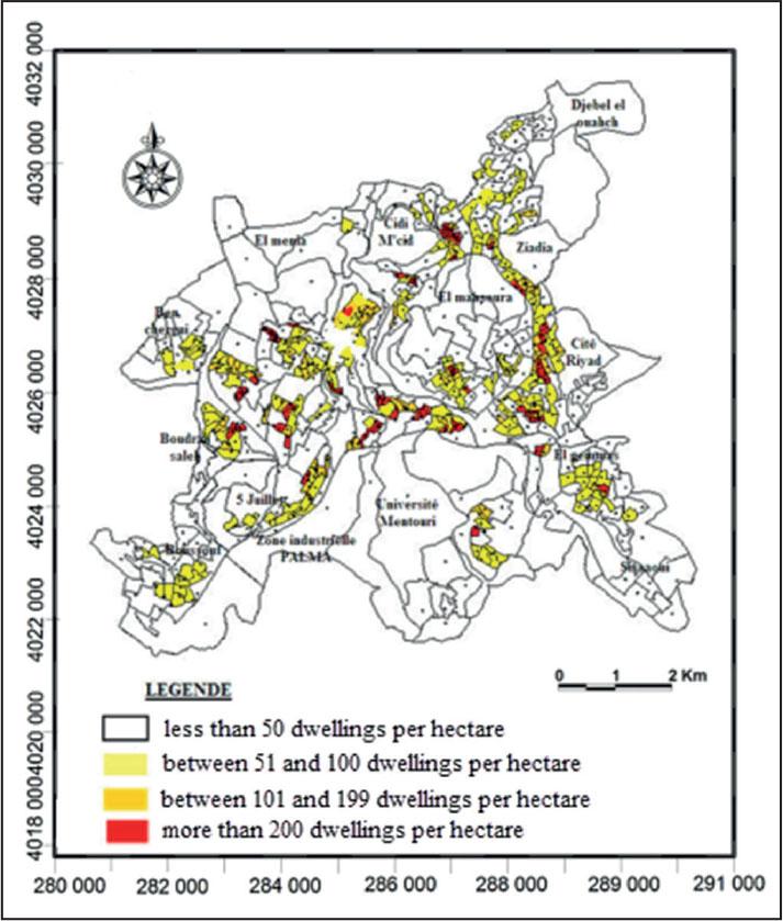
Density of dwellings in the municipality of Constantine
Source: own work.
Classification of the housing density index in the city of Constantine
| Index (CDI) dwelling | (CDI1) = 1 | (CDI2) = 2 | (CDI3) = 3 |
|---|---|---|---|
| Number of homes per 1 ha | 50‒100 | 100‒200 | >200 |
| Degree of risk | medium | high | very high |
| Color of risk | yellow | orange | red |
Source: own work.
The degree of vulnerability is determined through a calculation in which we assessed the importance of each index for the maps. The overlay of these maps, all at the same scale, allows us to classify vulnerability into three descending levels as follows:
- –
Degree III: high vulnerability area (red),
- –
Degree II: medium vulnerability area (orange),
- –
Degree I: low vulnerability area (green).
Figure 12 can serve as an important tool to identify areas where urban improvement is necessary, as well as to optimize rescue operations in the event of a landslide.
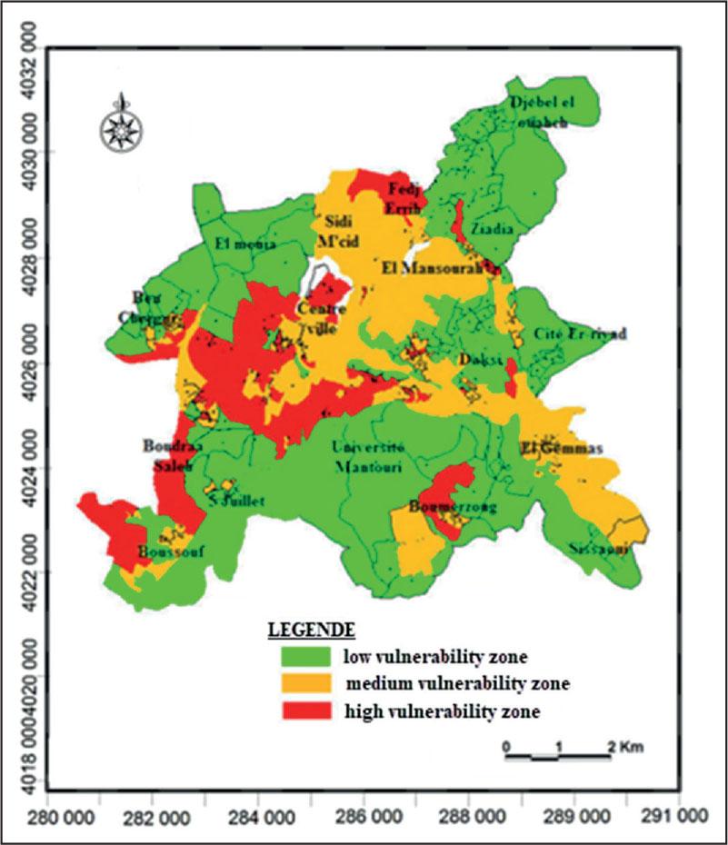
Landslide vulnerability of the city of Constantine
Source: own work.
Model validation is a crucial step in assessing its reliability and robustness. In the context of the study on the vulnerability of the city of Constantine to landslides, a comparative approach was adopted to compare the results of the developed model (Bui et al., 2020; Merghadi et al., 2020) with those from a previous reference study conducted by the consulting firm ARCADIS-Simecsol through its subsidiary EEG (Engineering Studies Company), and the Department of Urban Planning and Construction (DUC), in collaboration with the National Technical Control and Construction Agency (CTC) between 2001 and 2004.
The model developed in the context of this study is based on a multi-parametric approach that integrates six key factors influencing vulnerability to landslides, namely: rainfall, topography, geology, hydrology, seismicity, and land use.
These parameters were prioritized through a survey conducted among the scientific community, which allowed for weighting each factor according to its perceived importance. The weighting derived from this survey was then used to generate a vulnerability map at the municipal scale.
To validate the obtained map, a spatial overlay was performed with the one derived from the ARCADIS-Simecsol study, which serves as a reference for natural risk analysis in Constantine. This overlay allowed for a comparison of the areas identified as at risk in both studies. The results of this comparison revealed a similarity of approximately 97% between the two maps, indicating a strong alignment between the methods used. This proximity can be explained by the consideration of the same major terrain parameters, although the methodological approaches differ (multi-criteria modeling versus more in-depth geotechnical and historical analysis in the ARCADIS-Simecsol study).
The high similarity rate obtained (97%) demonstrates that the developed model is robust and relevant, particularly for urban-scale applications. This cross-validation also confirms the spatial consistency of the identified risk areas, whether they are regions known for their instability (such as the slopes of Bardo, Sidi M’Cid, or Djebel Ouahch) or new areas revealed through modeling.
The comparison with the results of the ARCADIS-Simecsol study provides evidence of the validity of the model used in our study. It confirms that, despite the use of distinct methods, both approaches lead to nearly identical conclusions. This validation grants the model scientific credibility and operational utility for urban planning, risk prevention, and natural disaster management in the city of Constantine.
The results show that areas with high slope gradients, weak geological formations, and intense or poorly managed urban development – particularly near drainage networks – correspond to zones of high vulnerability. Rainfall emerged as the most significant factor according to experts’ opinions, reflecting the triggering role of water saturation in slope failure. This is consistent with global and regional literature (Guzzetti et al., 2007; Papathoma-Köhle et al., 2017), which emphasizes precipitation as the primary external driver of landslides.
The model also revealed areas of medium and low vulnerability, often corresponding to regions with gentle topography, stable lithology, and lower anthropogenic pressure. These spatial variations underline the importance of using a weighted multi-parametric approach rather than treating vulnerability as a uniform condition across the urban landscape.
The assessment of landslide vulnerability in an urban context, such as that of the city of Constantine, represents a major challenge for natural risk management. The systemic and multi-criteria approach adopted in this study allowed the prioritization of influencing factors and the generation of a precise map of risk areas. The results obtained, validated by a rigorous comparison with a reference study, confirm the relevance of the model used. This approach thus provides a solid scientific basis for guiding urban planning decisions, improving the area’s resilience to natural disasters, and optimizing prevention strategies. By highlighting the importance of integrating physical, climatic, and human data, this study demonstrates the need for interdisciplinary approaches to address the challenges posed by environmental risks in urbanized areas.
This study addresses a scientific gap in the application of structured, expert-informed vulnerability modeling to complex urban environments in North Africa. The integration of physical, climatic, and human factors offers a holistic perspective on landslide risk that can guide both academic research and policy interventions.
From a practical standpoint, the model can support municipal authorities in prioritizing areas for risk mitigation, infrastructure reinforcement, and emergency planning. Furthermore, its adaptability makes it suitable for replication in other urban contexts with similar geological and climatic profiles.
While the model provides reliable results, it is based primarily on static spatial data and expert judgment. Future work could enhance accuracy by incorporating dynamic environmental data (e.g., real-time rainfall or soil moisture) and machine learning techniques to refine weightings. Moreover, including socio-economic vulnerability indicators would offer a more comprehensive risk assessment.