
Introduction
Contemporary technology profoundly impacts people’s lives, evolving from a mere tool to a vital force in fields such as health, education, sports, and the military. Augmented reality (AR) is one of the most sophisticated technologies that brings great convenience to human life. When the studies in the literature are examined, AR technology has been popular in recent years and used in many fields (Pinandita et al., 2023).
According to Milgram and Kishino (1994), AR has various definitions and involves situations where the real world is enhanced by adding virtual elements such as video, graphics, text, and sound (Harley et al., 2016). As stated by Azuma (1997), it refers to the technique of combining virtual items with the physical world. AR is used in various fields, including but not limited to tourism, education, medical technologies, and entertainment (Laor et al., 2022; Zaifri et al., 2023; Zhu et al., 2014). Essentially, AR can be explored under two categories: image-based AR and location-based AR (LBAR). Image-based AR uses visual markers (triggers) to augment the physical world with virtual information. Conversely, LBAR or markerless AR is not entirely dependent on visual marker triggers. LBAR uses geospatial data via GPS and wireless networks to determine the user’s location. It enables the system to overlay digital content based on the user’s actual physical position in the real world (Cheng & Tsai, 2013). Its popularity increased with the rise of Wi-Fi and GPS-enabled mobile devices, especially due to the success of LBAR games such as Pokémon Go (Alha et al., 2023).
Location-based augmented reality (AR) possesses significant opportunities for educational experiences in different areas, including the exploration of historical landmarks, museums, and urban environments. However, the volume of research on this topic is comparatively limited compared to marker-based AR. This lack of extensive research may be attributed to GPS signal problems, which can sometimes be unreliable or nonexistent, resulting in inaccurate location tracking (Akçayır & Akçayır, 2017; Kleftodimos, Moustaka, et al., 2023). Therefore, the literature can still benefit from further studies on location-based AR to enhance the knowledge in this domain (Kleftodimos, Evagelou, et al., 2023; Kleftodimos, Moustaka, et al., 2023). Furthermore, location-based AR might align well with contemporary constructivist learning approaches such as situated and authentic learning (Tzortzoglou et al., 2023). In this study, we employed the LBAR technology and tested its effectiveness in the orientation sessions of newly enrolled university students, who benefited from learning about the university’s core departments.
New Student Orientation Programs
Ensuring the integration and adaptation of students to education is a critical problem. University life is not like high school. In university, students live in shared accommodations or dormitories with classmates from various cultural backgrounds. Many students struggle to adapt to their new environment because they lack sufficient knowledge about the opportunities and resources that their institutions offer. Universities hold orientations to help students navigate their massive campuses, find their intended academic units, and identify locations that accommodate their specific needs (Chou & ChanLin, 2012; Dılekmen, 2007; Kutlu, 2005; Nguyen et al., 2018).
“Orientation is a unique and relatively short-term training program prepared by authorities in a workplace or school environment to help individuals adapt to their surroundings, job, or school” (Ceyhan, 1995, p. 14). Orientation programs play an essential role in helping students transition from high school to university. Such programs introduce students to campus, facilities, and other social networks, thereby improving their sense of university belonging (Fitz-Walter et al., 2012). However, organizing, implementing, and assessing orientation programs can be challenging. First, orientation programs are sometimes integrated into the official program and sometimes conducted at other times than the official program, which creates confusion for students. Hence, it is essential to have a well-prepared and carefully planned orientation program before the start of school to ensure the effectiveness of the orientation service (Tüzün & Özdinç, 2016). Sometimes, orientation programs might be too brief and limited because universities not located in metropolitan cities might not handle this process effectively since they do not have effective counseling and guiding services (Kutlu, 2005). Moreover, newcomer students may be unaware of the existence of orientation programs, possibly because of problems related to announcements or campaigns. In sum, despite the efforts of institutions to execute orientation programs effectively, their effectiveness is questioned. This might be due to some students being unable to participate because of some external factors, or the program is conducted in a limited time, and the university does not have a mandatory attendance policy (Özdinç 2010; Tüzün ve Özdinç 2016).
Approaches in the Orientation Program
Various strategies have been implemented to enhance the efficacy of orientation programs to meet the different requirements of students and the changing dynamics of educational environments. Traditional face-to-face orientation programs may include campus tours, a presentation of university resources, and policies. These programs may also involve practical tasks, such as obtaining IDs, enrolling in classes, and finding key university locations (Korstange et al., 2020).
Recent studies on new student orientation programs have also incorporated sophisticated methodologies to complement more traditional ones. For example, integrating creative drama activities has helped students become more engaged, build better social networks, and improve skills across different educational levels (Selçuk & Oğuz, 2015; Tosun & Demir, 2024). Miller and Pope (2003) studied the most effective orientation approaches based on the views of senior student affairs officers. They demonstrated that the most efficient way to incorporate technology into orientation sessions is to provide new students with email accounts upon arrival. In the study, professionals voted positively on highlighting the importance of technology, utilizing virtual school tours online, and having a college web treasure hunt (Miller & Pope, 2003). Another study showed that a properly organized self-directed online orientation may increase students’ motivation and readiness (Mshayisa & Ivala, 2022). Considering the limitations of face-to-face orientations, which are generally adopted by most institutions, Golubski (2011) suggested an alternative orientation method, enabling virtual onboarding and supporting students with the help of Web 2.0 technologies. Social bookmarking, Twitter, Instant Messaging, Skype, wikis, weblogs, podcasts, social bookmarking, Google Groups, and Facebook can be adopted. Tüzün and Özdinç (2016) tested the effectiveness of 3D multi-user virtual environments (MUVEs) in the departmental orientation of first-year students. It was demonstrated that 3D MUVEs can be efficiently employed for first-year orientation, producing comparable or superior results in terms of spatial and conceptual knowledge compared to traditional face-to-face methods (Tüzün & Özdinç, 2016).
Using Augmented Reality (AR) For Navigation and Orientation
Location-based augmented reality (LBAR) applications have gained popularity in the context of orientation and navigation. For example, Chou and ChanLin (2012) tested the effectiveness of a smartphone-based AR campus touring system. The system offered real-time navigation assistance, uncovering the hidden contextual information in the real environment. Harley et al. (2016) combined AR technology with multimedia resources to test its effectiveness in the context of a guided historical tour. They demonstrated that the AR system increased the engagement of students in the historical content, promoting independent learning and historical reasoning by understanding the historical differences. Efstathiou et al. (2018) examined the role of an LBAR inquiry-learning environment in promoting historical reasoning. The program was effective in facilitating empathy and historical reasoning, especially in informal learning settings. Kyza and Georgiou (2019) developed a location-based TraceReaders app to enhance historical reasoning and environmental science inquiry in students. The results demonstrated that LBAR enhances learning through interaction with the environment.
From these studies, it can be argued that LBAR can enhance user experiences by developing immersive and interactive experiences. It can provide contextual real-time data pertinent to the location of users, enabling step-by-step guidance in unfamiliar places. In this sense, LBAR can be a valuable tool for facilitating orientation and navigation for new students, who can engage with the orientation program at their convenience, allowing them to address their needs independently at any time.
One potential of LBAR might be its capacity to foster students’ spatial ability, which is the knowledge and skill necessary to encode, recall, or retrieve visual information as well as mentally visualize and manipulate objects (Colom et al., 2002; Postma et al., 2004). Spatial knowledge is essential for several daily activities that affect how humans navigate their environments, execute tasks, and engage with spatial information. These tasks include navigating unfamiliar places, assessing distances between different locations, deciding the direction of places, and effectively reading maps (Thorndyke & Goldin, 1983).
Considering the use of technology for orienting or navigating, it has been demonstrated that multi-user immersive virtual environments may potentially enhance spatial learning. For example, Tüzün and Özdinç (2016) found that multi-user virtual environments enhance spatial route learning, although no significant differences were obtained in terms of spatial landmark learning. Other research showed that automated navigation systems might facilitate spatial knowledge acquisition and navigation performance despite the disadvantage of distracting users from their surroundings. Therefore, active participation strategies have been suggested for deeper spatial knowledge acquisition (Brügger et al., 2019). The limitations of the passive characteristics and potential distractions of existing navigation systems can be mitigated by incorporating location-based augmented reality (LBAR) technology. Empirical studies indicate that LBAR glasses enhance path remembering relative to smartphones. User experience studies indicate a preference for LBAR glasses over smartphones, as they allow users to maintain awareness of their environment without splitting their attention between the device and their surroundings, thus enhancing situational awareness and spatial engagement (Lakehal et al., 2023).
Problem Statement and Research Questions
Considering their previous high school experience, first-year students are adjusting to a novel and somewhat different academic environment. If students lack assistance throughout their school years and do not experience a sense of belonging within the university community, they may experience withdrawal, and dissatisfaction may occur (Dılekmen, 2007; Tosun & Demir, 2024). Consequently, orientation sessions are crucial for university students. Universities implement several orientation programs to aid students’ adaptation. While most universities meticulously implement this program, its efficacy is diminished by the presence of students who cannot participate due to various external factors or because the university does not mandate participation, and the program is scheduled for a limited time. These barriers engender skepticism over their overall effect on students’ integration and achievement (Kutlu, 2005; Tüzün & Özdinç, 2016). An application based on location-based augmented reality (LBAR) technology, which is compatible with most smartphones or other GPS and Wi-Fi-enabled mobile devices, is projected to address the orientation requirements of students who cannot participate in orientation training or those who cannot benefit from face-to-face orientation sessions. The relatively limited availability of studies examining the application of LBAR technology in the context of first-year students’ adaptation or orientation signifies a notable opportunity to test the effectiveness of this technology. Incorporating LBAR into the orientation program may enhance students’ spatial abilities, reduce confusion stemming from a lack of awareness about the process, mitigate adaptation issues resulting from missed sessions, and address confusion caused by conducting the orientation program at times other than the official schedule. The information obtained from this research will shed light on the preparation of an LBAR-supported orientation program. This study examines the effectiveness of a location-based augmented reality (LBAR) application in the new students’ orientation process. To achieve the stated objective and evaluate the software’s effectiveness, students’ retention of institutional information presented during the orientation was compared between the face-to-face and LBAR orientation groups. Additionally, the groups were compared based on their spatial knowledge, and students’ opinions on the LBAR software were gathered. The following research questions were explored in this study:
RQ1. Is there a significant difference between the pre- and post-test knowledge scores of the groups receiving orientation according to different approaches (LBAR and physical human-guided orientation)?
RQ2. Is there a significant difference between the post-test knowledge scores of the groups receiving orientation according to different approaches (LBAR and physical human-guided orientation)?
RQ3. Is there a significant difference between the spatial knowledge scores of the groups receiving orientation according to different approaches (LBAR and physical human-guided orientation)?
RQ4. What are the opinions of students on the LBAR software?
Method
Participants and Design of the Study
This study employed a pre- and post-test design with one control and one experimental group. The study’s dependent variables are knowledge tests and spatial knowledge scores. The treatment condition was the independent variable. After the experiment, data regarding the experimental group’s opinions on the LBAR software were collected. Table 1 presents demographic characteristics of the students.
Table 1
Demographic characteristics of the students.
| VARIABLE | GROUP | N | % |
|---|---|---|---|
| Gender | Female | 26 | 59.1 |
| Male | 18 | 40.9 | |
| Years of mobile phone use | 1–5 | 13 | 29.6 |
| 6–9 | 25 | 56.9 | |
| 10+ | 6 | 13.6 | |
| Regular use of a mobile phone (Yes/No) | Yes | 44 | 100 |
| No | 0 | 0 | |
| Mobile literacy level | Low | 5 | 11.4 |
| Medium | 35 | 79.5 | |
| High | 4 | 9.1 | |
| Map literacy level | Low | 16 | 36.4 |
| Medium | 23 | 52.3 | |
| High | 5 | 11.4 | |
| Years of Internet use | 0 | 0 | 0 |
| 1–5 | 7 | 15.9 | |
| 6–9 | 21 | 47.8 | |
| 10+ | 16 | 36.3 |
As presented in Table 1, 26 (59.1%) and 18 (40.9%) students were female and male, respectively. The participants’ average age was 19.07 years, with an average of 6.77 years of mobile phone use and 8.36 years of internet use. All participants reported regular mobile phone use. Mobile literacy levels analysis revealed that 11.4% of students exhibited low-level mobile literacy, 79.5% displayed medium-level mobile literacy, and 9.1% demonstrated high-level mobile literacy. In terms of map literacy, 36.4% of participants were classified as having low literacy, 52.3% had medium literacy, and 11.4% possessed high literacy.
Design and Development of the LBAR Software
The Location-Based Augmented Reality (LBAR) software was developed as a part of this study to assist new students in orienting the campus environment. LBAR software aims to enhance the user experience by visualizing on-campus navigation with AR. The application serves a dual purpose: (a) delivering institutional information (e.g., faculties, departments, and other departmental points) and (b) providing spatial orientation support through location-based AR navigation. Several software development models were evaluated before development. The reuse-oriented model was chosen (Sommerville, 2016) because it focuses on integrating pre-existing software components to enable rapid and cost-effective development. This approach was well-suited to the project’s requirements, as the LBAR application utilized existing platforms and tools, including Unity 3D for core application development, the ARCore SDK for AR functionality, and the AR+GPS Location Unity Package for combining AR with GPS-based routing. The software features were determined through consultations with two faculty members. The architecture consists of three main screens: the login screen, the list screen, and the routing screen. (1) The Login Screen shows a tutorial for first-time users on how to use the app, including the institution logo, a background image relevant to the app’s purpose, a start button to navigate to the list screen, the version number, an “About” button, a “How to Use” button, and an exit button to close the app. Clicking the Start button opens the List Screen. (2) The List Screen displays a list of the institution units and faculties. The user is directed to a detailed information screen that includes administrative staff, departments, history, faculty members, and room numbers upon selecting a unit or faculty. After reviewing the information, the user can access the routing screen by clicking the “Get Directions” button. (3) The routing screen uses augmented reality (AR) for navigation by utilizing the device’s global positioning system (GPS) and compass functions. Here, the app asks permission to access the user’s location and camera. Location access helps identify the user’s position for navigation, while camera access activates AR features. Once permissions are granted, the Routing Screen displays directions to the selected unit or faculty using both the AR+GPS Location and ARCore plugins. The user’s location is detected and compared with the GPS data of the selected unit or faculty, and a route is calculated. The user is then shown a virtual signboard and route line using AR technology. The signboard displays the routing command, the selected unit or faculty name, the remaining distance, and a refresh button. The refresh button helps resolve issues, such as stuttering or freezing, that may occur due to device hardware limitations encountered during the preliminary testing phase. The flow diagram of the application is shown in Figure 1.
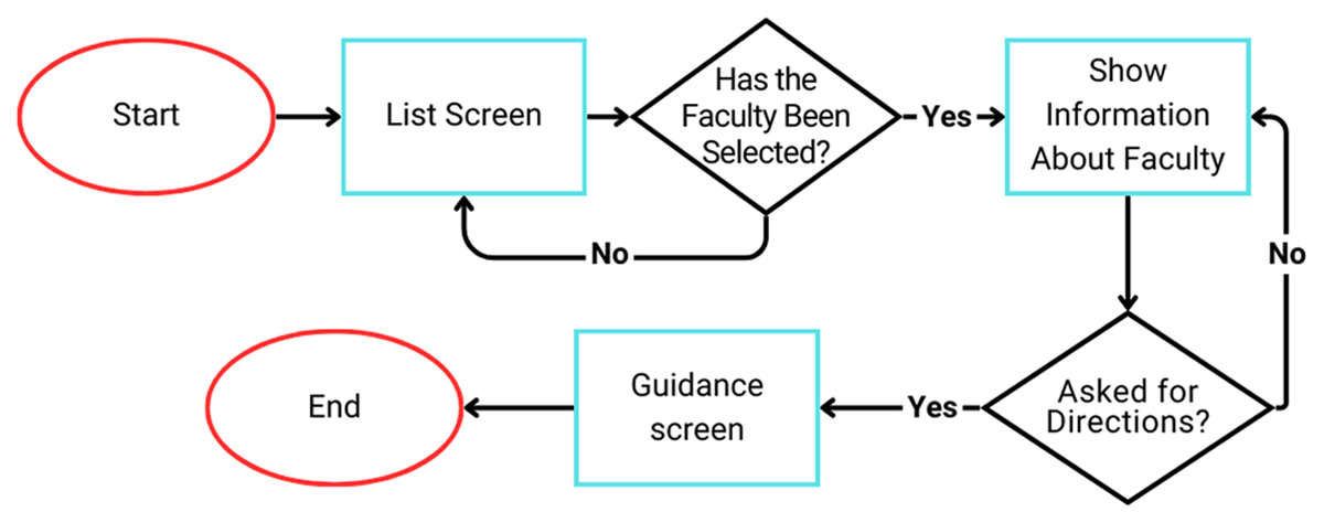
Figure 1
Flow diagram of the proposed LBAR application.
Figure 2 also provides a screenshot from the LBAR software.
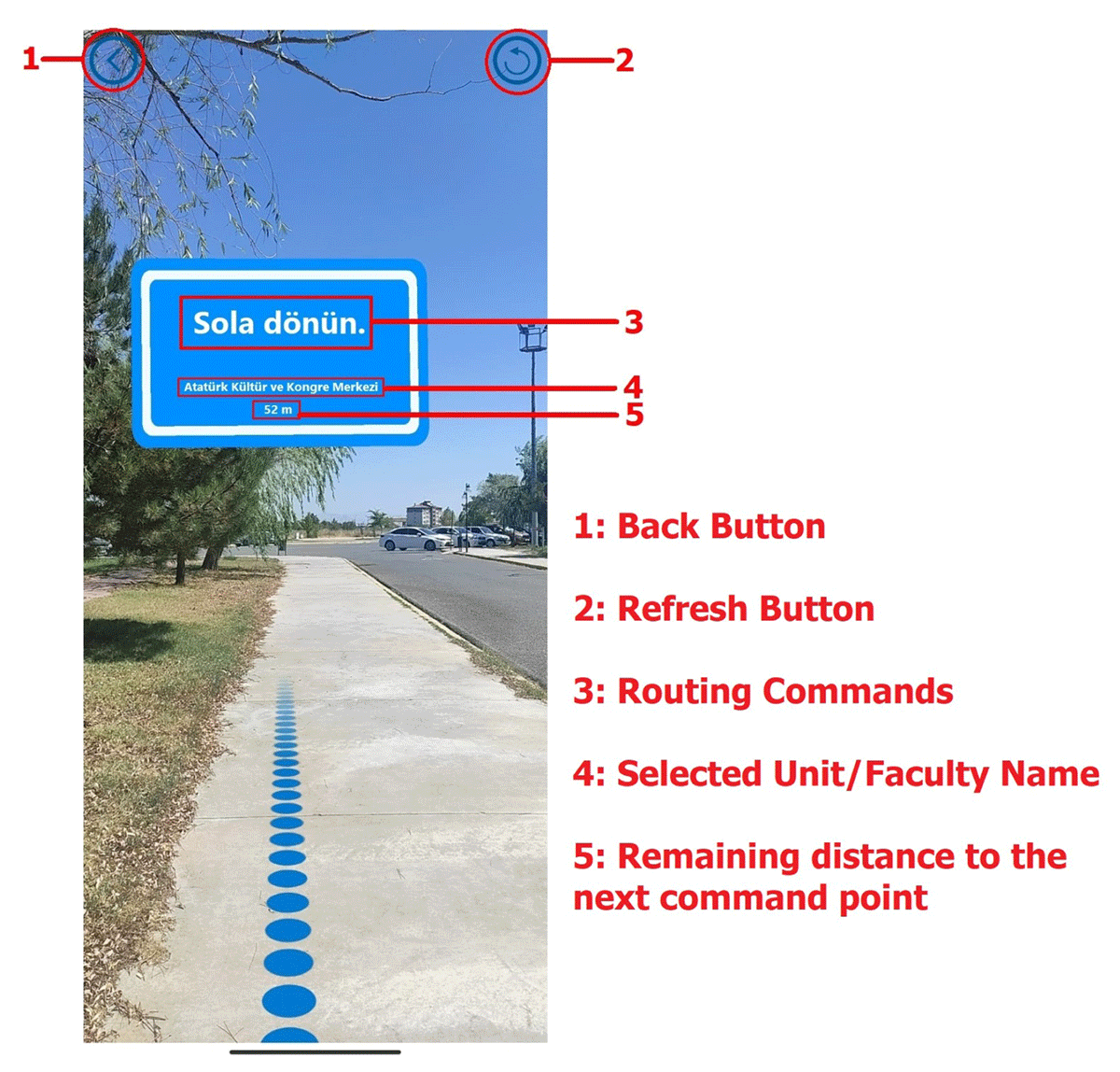
Figure 2
Screenshot of the LBAR application.
The AR+GPS location package was selected for software implementation because it uniquely integrates AR technology and has routing functionality. This add-on, designed explicitly for LBAR applications, uses GPS coordinates to facilitate the real-time positioning of objects in physical environments and includes capabilities for user location detection and routing operations. A notable feature of this study is the capacity of the add-on to detect the user’s location and orientation, guiding for navigational purposes. The package that provides the core functionalities of the application was purchased through the Unity library. Figure 3 depicts the operational flow of the package.
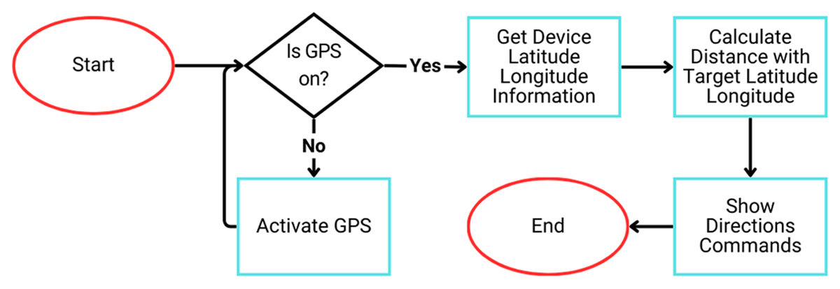
Figure 3
AR + GPS location package flow diagram.
As illustrated in Figure 3, the package retrieves the user’s GPS data (latitude and longitude), compares it with the target’s GPS data, calculates the distance and route, and guides the user to the destination using AR technology. In summary, the main functionalities of the software are real-time navigation using GPS + AR Core integration, virtual markers, voice notifications, and user location stabilization. After the application design and coding processes were completed, the application file was uploaded to the Play Store, the Android application store, with the researcher’s profile.
Data Collection Tools
The data collection tools included demographic forms, knowledge tests regarding the faculties, units, and other institutions, a spatial knowledge test, and a mobile orientation evaluation questionnaire.
Knowledge Test
In this study, a 20-item short answer knowledge test was developed to be administered before and after the study. The test questions were created by utilizing the institutional knowledge covered by the LBAR software. Two faculty members working at the institution reviewed the items. Following the feedback of the faculty members, the questions were revised, and the number of questions was reduced to 10. The final version of the test was administered as a pre-test and a post-test. Each correct answer received 2 points, 1 point for partially correct answers, and 0 points for incorrect answers. The post-test knowledge scores of the groups were scored by two researchers, and the agreement index between the raters was calculated using the intraclass correlation coefficient (ICC). This value was 0.98, indicating a high level of agreement between the raters.
The Spatial Knowledge Test
The researcher created the spatial knowledge test to ascertain the degree of spatial knowledge of the students regarding the university campus. The test was adopted by referring to a previous study (Tüzün & Özdinç, 2016). The test included only one question, asking participants to sketch the campus. In other words, the students were required to sketch an overview of the locations they had visited during the orientation.
The Spatial Knowledge Questionnaire Assessment Form
The spatial knowledge test assessment form was developed to evaluate the students’ spatial knowledge, in which the sketches they drew were assessed. The form was created by benefiting from a similar study (Tüzün & Özdinç, 2016). “Example questions are: “The main entrance with the security gate is drawn,” “Rectorate building is drawn.” Each correct answer is awarded 2 points, 1 point for partially correct answers, and 0 points for incorrect answers.
Mobile orientation evaluation questionnaire
A 20-item Orientation Evaluation Questionnaire was utilized to obtain students’ beliefs regarding the LBAR mobile software. The Internet/WWW questionnaire developed by Cheung and Huang (2005) and adapted by Tüzün and Özdinç (2016) was reviewed by two faculty members working at the institution with the permission of the researcher. The 27-item 5-point Likert-type questionnaire was adapted, and the number of items was reduced to 20 based on the recommendation. The final version of the mobile orientation evaluation questionnaire, consisting of 20 items in a 5-point Likert-type form, was used in the study, with 1 point indicating complete disagreement and 5 points indicating complete agreement.
Implementation Process
A preliminary study was conducted to determine the initial effectiveness. The effectiveness of the LBAR application was tested with 15 second-year students. In the preliminary research, the students were asked to install the application, and three students who could not install the app were excluded from the study. The application could not be installed because some phones did not support the ARCore technology used in the development of the application, and some students used phones with operating systems other than Android. The students who installed the application were asked to visit different faculty or unit locations. The participants were then asked to complete the interview forms. The forms were analyzed in collaboration with a faculty member, identifying deficiencies and suggestions.
The application displayed certain deficiencies, such as freezing on certain devices, requiring precise interaction with virtual direction signs for navigation, miscalculating location leading to routing inaccuracies, inability to function with all versions of operating systems, and lack of support for devices not equipped with ARCore. To address these issues, the software was updated to improve location tracking stability and reduce the need for precise interaction with routing signs. A refresh button was added to address the freezing issue. However, compatibility with non-Android and ARCore-dependent devices remains unresolved due to technical limitations, although future ARCore updates may offer a solution. The students involved in the test study also proposed suggestions for enhancing the app’s functionality. These recommendations included incorporating the local language instead of the English interface, alerts when going wrong, a map on the orientation screen, and performance improvements. The feasible suggestions were implemented, leading to improved app performance.
Before the actual implementation, students were informed and consented to participate. Ethical approval was obtained from the Research Ethics Committee of the institution where the study was conducted (06.09.2023/206115). Both groups were informed of the orientation plans. All students took the pre-knowledge test and completed the demographic information form. The students were then asked to install the developed application from the Play Store on their phones. Those who installed and ran the application on their smartphones were assigned to the experimental group. Students whose phones were not compatible with the app or lacked an Android OS were assigned to the traditional, guided, face-to-face orientation group (control group).
Students in the experimental group were introduced to the application interface and taught how it works. Students were sent on campus tours to complete tasks assigned using the LBAR software. The participants required 30 minutes to complete the tasks, and after task completion, they were requested to return to the designated departure point, which was also the meeting point. Students in the control group were guided on a campus tour, adhering to the physical orientation flow. During the tour, relevant information was provided, and the students’ questions were addressed. For the students in the control group, institutional knowledge was provided verbally. The students returned to the designated meeting point after the tour ended. All students completed the post-tests after completing the tasks. The experimental group also provided data on their opinions about the LBAR software.
Data Analysis
The dataset comprised quantitative measures from 44 participants with different questionnaires and tests, including 23 students in the experimental group and 21 students in the control group. Data were collected during the fall period of the 2023–2024 academic year. Descriptive and inferential statistical methods were used for data analysis. Demographic and orientation evaluation questionnaire responses were analyzed using the descriptive statistics method. To determine whether the groups showed significant differences in the pre- and post-test knowledge test, a paired sample t-test was used separately for both groups. An independent sample t-test was used to determine whether the groups had similar characteristics before the experiment. Similarly, an independent sample t-test was used to compare the groups’ post-test knowledge scores. Finally, an independent sample t-test was used to determine whether the groups’ spatial knowledge scores differed. The IBM SPSS 27 statistical package was used for the statistical analyses.
Results
This study used paired and independent-sample t-tests to analyze the data. The dependent variables were scores of pre- and post-test institutional and spatial knowledge tests. The treatment condition was the independent variable. Shapiro-Wilk tests, skewness, and kurtosis values were used to assess for normality. Pre-and post-test differences showed normal distribution (Shapiro-Wilk p > .05, skewness/kurtosis within -2 to +2; George & Mallery, 2010). Spatial knowledge data also met normality assumptions (p > .05, skewness/kurtosis -2 to +2). The normality assumptions for both tests were satisfied.
The similarity of the control and experimental groups was determined before analyzing the data. The pre-test knowledge scores, which were used to assess the familiarity of the participants with the campus, were compared to determine any significant differences between the groups. To this end, an independent samples t-test was employed, and Table 2 displays the results.
Table 2
Pretest knowledge scores.
| GROUPS | N | PRE TEST | ||||
|---|---|---|---|---|---|---|
| M | S | Sd | t | p | ||
| Experimental | 23 | 5.13 | 2.865 | 42 | 1.949 | .058 |
| Control | 21 | 7.10 | 3.793 | |||
Table 2 shows no significant difference in pre-test scores between the experimental (M = 5.13) and control groups (M = 7.10) (t(42) = 1.949, p >.05), indicating similar prior knowledge scores about the campus. From this point of view, the groups participating in the study had similar characteristics. Next, research questions were analyzed.
RQ1: Is there a significant difference between the pre- and post-test knowledge scores of the groups receiving orientation according to different approaches (LBAR and physical human-guided orientation)?
We used paired sample t-tests for each group separately to compare their pre- and post-test knowledge scores and determine whether the orientation process had a different effect on students’ learning of campus faculties and units. This test determines whether their knowledge before and after the orientation differed significantly.
First, the experimental group data were analyzed. The mean post-test score of the students (experimental group) who participated in location-based augmented reality (LBAR) orientation was calculated. A statistically significant enhancement was observed between the pre- and post-test knowledge scores for students who participated in the LBAR orientation. The mean post-test (M = 8.04) score of the experimental group increased compared to the mean pre-test (M = 5.13) score. This increase was statistically significant t(22) = 4.502, p < .05). In other words, students’ knowledge about the campus units and faculties increased because of the exposure to the LBAR mobile orientation session (Figure 4).
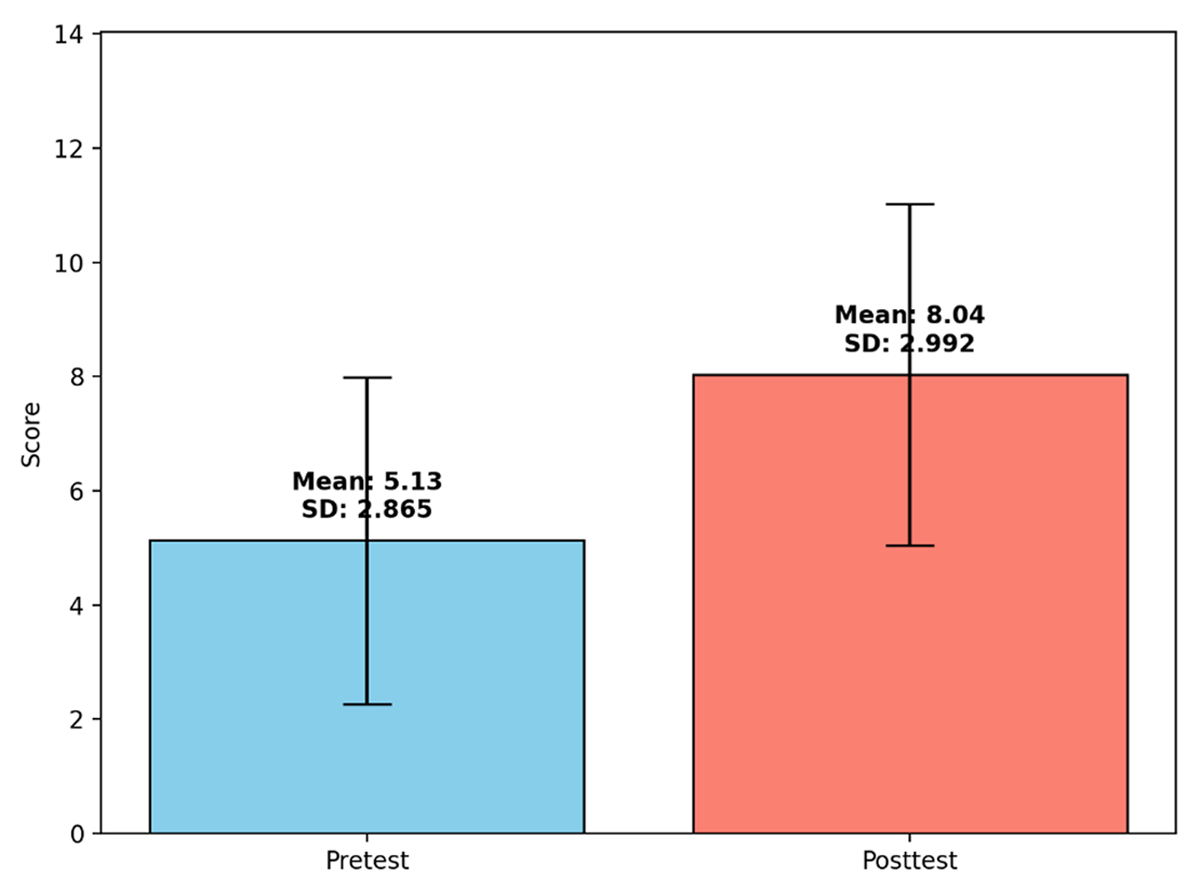
Figure 4
Comparison of the pre- and post-test scores of the knowledge test for the experimental group.
Next, we assessed whether the control group (face-to-face, guided physical orientation program) exhibited a statistically significant difference in their knowledge about campus units and faculties before and after the orientation. The average post-test score (M = 13) was higher than that of the pretest (M = 7.10). This increase was significant (t(20) = 8.018, p < .05), suggesting that the face-to-face orientation program improved students’ knowledge about campus units and faculties (Figure 5).
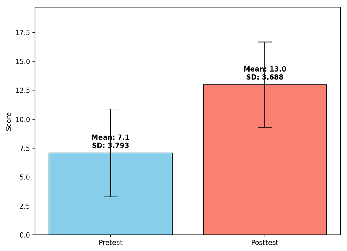
Figure 5
Comparison of the pre- and post-test scores of the knowledge test for the control group.
The findings suggest that students’ knowledge scores concerning campus units increased with LBAR and physical human-guided orientations, indicating that both methodologies enhanced retention of institutional knowledge about different units or departments.
RQ2. Is there a significant difference between the post-test knowledge scores of the groups receiving orientation according to different approaches (LBAR and physical human-guided orientation)?
The independent sample t-test method was used to determine whether there was a significant difference between the experimental and control groups’ post-test knowledge test scores. The results are shown in Figure 6.
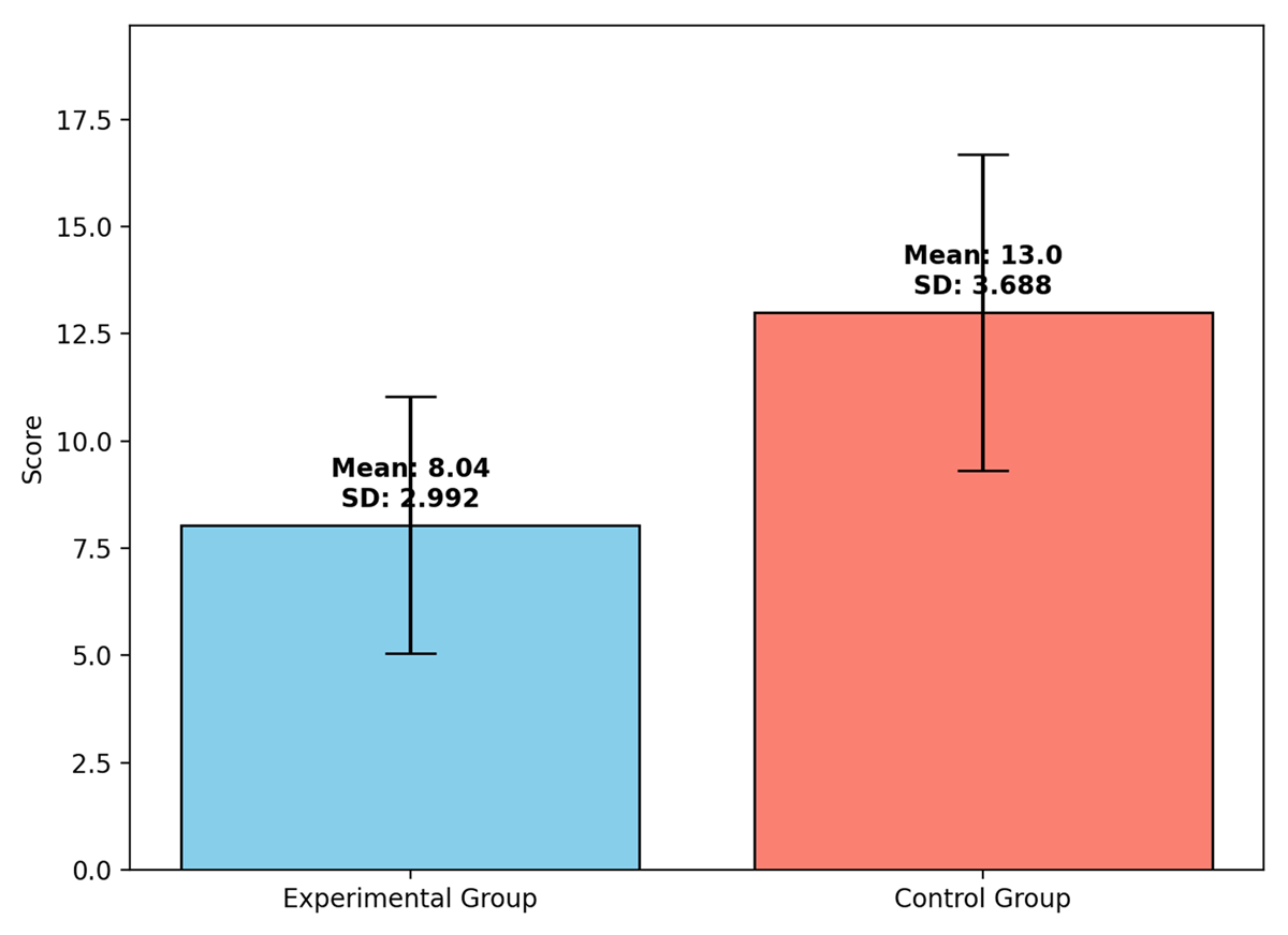
Figure 6
Comparison of the post-test knowledge scores.
As demonstrated in Figure 6, the mean post-test score for the experimental group (LBAR-based orientation) was 8.04, whereas that for the control group (guided physical orientation) was 13. The analysis revealed a statistically significant difference in post-test knowledge scores between the two groups (t(42) = 4.915, p < .05). Notably, students who participated in the guided physical orientation exhibited significantly higher performance in acquiring knowledge about campus units and faculties than those who used the LBAR-based orientation.
RQ3. Is there a significant difference between the spatial knowledge scores of the groups receiving orientation according to different approaches (LBAR and physical human-guided orientation)?
The spatial knowledge of students in the experimental (LBAR application) and control groups (guided physical orientation) was compared using an independent samples t-test. Table 3 indicates that the experimental group’s mean score for spatial knowledge was 11.22, whereas the control group’s score was 11.57. The two groups did not differ statistically significantly (t(42) = .374, p > .05). This suggests that both orientation techniques enhanced the spatial knowledge of students in a comparable manner (Figure 7).
RQ4. What are the opinions of students on the LBAR software?
Table 3
Student opinions regarding the LBAR-based orientation.
| ITEMS | STRONGLY DISAGREE | DISAGREE | NEUTRAL | AGREE | STRONGLY AGREE | MEAN (sd) |
|---|---|---|---|---|---|---|
| 1. The LBAR-supported orientation made the campus exploration process more interesting. | 8.7% | 4.3% | 34.8% | 43.5% | 8.7% | 3.39 (1.03) |
| 2. I was able to get help with the difficulties I encountered using the LBAR-supported orientation environment. | 4.3% | 13% | 21.7% | 34.8% | 26.1% | 3.65 (1.15) |
| 3. The LBAR-supported orientation was complex, and it was difficult to understand what was happening. | 8.7% | 43.5% | 13% | 26.1% | 8.7% | 2.83 (1.19) |
| 4. LBAR-supported orientation had no effect on my campus-related experiences. | 21.7% | 30.4% | 26.1% | 21.7% | 0% | 2.48 (1.08) |
| 5. The LBAR-supported orientation motivated me to explore topics that I might not have known. | 4.3% | 13% | 8.7% | 52.2% | 21.7% | 3.74 (1.09) |
| 6. The LBAR-supported orientation built a useful bridge between my current novice period and my future student life. | 4.3% | 8.7% | 17.4% | 52.2% | 17.4% | 3.70 (1.02) |
| 7. The LBAR-supported orientation helped me get to know the campus in a shorter time. | 4.3% | 21.7% | 21.7% | 43.5% | 8.7% | 3.30 (1.06) |
| 8. LBAR-supported orientation is an effective way to learn while exploring the university campus. | 4.3% | 13% | 17.4% | 47.8% | 17.4% | 3.61 (1.07) |
| 9. Participating in the LBAR-supported orientation was fun. | 4.3% | 13% | 4.3% | 56.5% | 21.7% | 3.78 (1.08) |
| 10. LBAR-supported orientation was conducted at a time when I needed to get acquainted with the campus. | 4.3% | 8.7% | 17.4% | 43.5% | 26.1% | 3.78 (1.08) |
| 11. Necessary information about LBAR-supported orientation was provided. | 4.3% | 17.4% | 0% | 56.5% | 21.7% | 3.74 (1.13) |
| 12. Learning the LBAR-supported orientation process took a lot of time. | 17.4% | 30.4% | 30.4% | 17.4% | 4.3% | 2.61 (1.11) |
| 13. LBAR-supported orientation significantly improved the quality of my experiences. | 4.3% | 13% | 34.8% | 34.8% | 13% | 3.39 (1.03) |
| 14. Exploring the campus through LBAR-supported orientation is a time-saving method. | 4.3% | 17.4% | 21.7% | 43.5% | 13% | 3.43 (1.08) |
| 15. LBAR-supported orientation allowed me to experience situations that I might encounter in my student life. | 4.3% | 8.7% | 26.1% | 39.1% | 21.7% | 3.65 (1.07) |
| 16. LBAR-supported orientation improved my performance in the campus exploration process. | 8.7% | 8.7% | 17.4% | 52.2% | 13% | 3.52 (1.12) |
| 17. The LBAR-supported orientation generally caught my interest. | 4.3% | 8.7% | 4.3% | 65.2% | 17.4% | 3.83 (0.98) |
| 18. The LBAR-supported orientation was generally very complex. | 21.7% | 17.4% | 39.1% | 17.4% | 4.3% | 2.65 (1.15) |
| 19. LBAR-supported orientation allowed me to better know the campus with less effort. | 4.3% | 17.4% | 30.4% | 34.8% | 13% | 3.35 (1.07) |
| 20. Overall, the LBAR-supported orientation application was helpful in the campus exploration process. | 4.3% | 13% | 21.7% | 52.2% | 8.7% | 3.48 (0.99) |
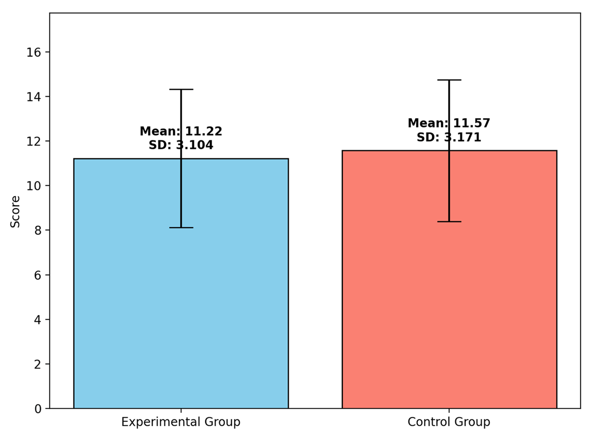
Figure 7
Comparison of spatial knowledge between the groups.
Upon completing the implementation phase, the students participating in the Location-Based AR Supported Orientation Program were requested to respond to a 20-item questionnaire comprising 16 positive and 4 negative statements, enabling them to articulate their perceptions regarding the orientation program. The collected data were then interpreted for each item through frequency analysis.
Discussion
This section discusses the results in relation to the existing literature. In this study, a mobile location-based augmented reality (LBAR) application was developed to be used in the adaptation process of new students to the university campus, and the application’s effectiveness was evaluated in terms of different variables. After the application was developed, it was uploaded to the Google Play Store. The application was tested in a pilot study with university students, and changes were made in response to their feedback. The students were invited to participate in the primary study on specified days. The collected data were analyzed, and the results were interpreted.
When the results were analyzed, a significant difference was found between the pre- and post-test achievement scores of learning campus units or faculties of both groups participating in the study. In other words, both orientation programs were successful. The results of this investigation are consistent with and support those of earlier studies on orientation programs, whether conducted using traditional or alternative approaches (Akhan & Karamık, 2019; Kyza & Georgiou, 2019; Tüzün & Özdinç, 2016). From this perspective, it could be argued that traditional orientation programs are beneficial in adapting students to new university environments (Dılekmen, 2007). In addition, supporting traditional orientation programs with different approaches can also produce helpful results. In this study, the improved learning outcomes from the AR-enhanced orientation program align with previous research, reinforcing the advantages of both traditional and technology-supported orientation initiatives.
Another research question examined whether a significant difference existed between the post-test knowledge scores of the experimental and control groups participating in different orientation programs. Contrary to expectations, the post-test knowledge scores of the students who participated in the physical orientation program with a guide were higher than those who participated in the orientation program with a location-based augmented reality (LBAR) mobile application. The results of the present study are consistent with those of Brata and Liang (2020), who found that although LBAR applications were rated in higher hedonic qualities (enjoyment and engagement), they did not improve navigation performance compared to more conventional methods, such as a two-dimensional digital map. On the other hand, the results of the current study contradict some other studies, showing the superior effects of orientation programs supported with innovative approaches compared to more standard programs (Harley et al., 2016; Kyza & Georgiou, 2019; Tüzün & Özdinç, 2016). The current study’s findings indicate that students who engaged in the physical orientation activity may have benefited more. This could be because those in the experimental group focused primarily on the orientation screen, potentially missing key institutional details about units, faculties, or buildings within the app. Additionally, the application content might not have been sufficiently interesting or compelling to keep students’ attention, which could have reduced its impact on learning and retention of facts about the institution. Furthermore, students in the experimental group used the application autonomously, with no human guidance provided, while those in the physical orientation program received verbal information about campus faculties and units from a human guide. This exposure may have contributed to their enhanced knowledge acquisition. Although innovative navigation and orientation approaches are often perceived as enjoyable, interactive, and engaging, conventional methods tend to offer more structured and practical experiences. This phenomenon may be attributed to usability challenges associated with location-based augmented reality (LBAR) environments (Brata & Liang, 2020; Esengun & İnce, 2016).
When the spatial knowledge scores of the students participating in the study were examined, no significant difference was observed between the spatial knowledge scores of the experimental and control groups. The literature provided similar results, showing that AR-based navigation systems did not generate superior spatial knowledge results compared with other navigation methods (Huang et al., 2012; Qiu et al., 2024). Even technology-supported maps may impede spatial knowledge acquisition. These technologies frequently require users to divide their attention between navigation and environmental comprehension. Consequently, users may experience difficulties in acquiring spatial knowledge effectively (Willis et al., 2009). Conversely, our study produced findings inconsistent with those of Lakehal (2023), who showed the beneficial effects of AR in terms of spatial knowledge acquisition. The insignificant outcomes related to spatial ability can be ascribed to numerous variables. Primarily, the participants in both groups engaged in analogous tasks, which involved navigating a predetermined, structured campus route with comparable environmental layouts. This likely induced similar levels of mental exertion in spatial representation across both groups. Moreover, spatial knowledge was evaluated by administering sketching tasks depicting the university campus. This assessment method posed challenges in accurately comparing the spatial knowledge of the groups. Finally, the virtual cues provided in the location-based augmented reality (LBAR) environment may have posed challenges for the experimental group, hindering their ability to form accurate spatial representations, which could be attributed to the cognitive load imposed by the application, potentially impeding effective spatial knowledge acquisition. Further empirical studies are necessary to draw solid conclusions about the impact of such technologies on spatial learning. The current findings suggest that while these technologies appear to be effective for navigation, they do not significantly improve spatial knowledge acquisition.
As a final process, the feedback from those who used the LBAR application was analyzed. The results revealed that the students were satisfied with the entire process. They expressed satisfaction with the application’s functionality. Furthermore, they found the LBAR-based orientation process to be engaging and innovative, emphasizing that it facilitated the process and contributed to significant time savings, thereby improving the overall experience. These findings indicate that the use of mobile-oriented solutions was both practical and well-received by the participants. These results are consistent with many studies showing the beneficial effects of AR technology in navigating people for various purposes (Chou & ChanLin, 2012; Harley et al., 2016; Zhang et al., 2019). As stated in the article by Tüzün and Özdinç (2016), the cost and time savings of traditional orientation programs are responsible for students’ satisfaction with the process. In line with this argument, the current study offers an alternative approach to the conventional orientation that reduces both costs and time. As opposed to the conventional approach, the integration of an innovative system (LBAR) into the process can help people gain the ability to manage the process with mobile devices and to complete the process independently, without reliance on units or individuals.
Conclusion
This study aimed to design and develop a location-based AR application and test its effectiveness in supporting the adaptation process of new students with the LBAR-based orientation approach. A literature review reveals research on AR and orientation services, but the combination of these services has been addressed to a lesser extent (Kleftodimos, Moustaka, et al., 2023). This study aims to understand the effect of the mixed use of AR and orientation services to provide a more inclusive understanding of these fields.
Results revealed that both groups increased their institutional knowledge after the orientation program. However, surprisingly, when the post-institutional knowledge scores were compared, the guided physical orientation group outperformed the LBAR application group. Additionally, no significant difference was found in the spatial knowledge scores between the groups. Students who used the LBAR application generally expressed positive feedback, highlighting its potential as a complementary tool after the necessary improvements were made. We conclude that LBAR has the potential to serve a significant function in orientation education, offering a valuable tool that can enhance the efficiency of the learning process. Its incorporation into orientation education can be beneficial in terms of time and resource allocation. The application’s efficacy is comparable to that of traditional physical orientation programs, making it a viable and innovative option for improving the overall orientation experience.
The current study has some limitations. First of all, an important limitation of the study was the assignment of participants to groups based on device compatibility rather than random assignment. This limitation, along with the small sample size, limits the generalizability of the findings. Furthermore, the present study did not analyze the usability of the developed application; future studies are needed to evaluate the program’s usability and usefulness, thereby informing potential improvements. Different theoretical frameworks, such as the Technology Acceptance Model and the Theory of Planned Behavior, can be used to evaluate the effectiveness of an application and identify factors that influence future usage intention. A questionnaire was used to collect data on users’ views of the LBAR app. Later studies could use in-depth interviews to reveal detailed user experiences.
Orientation includes information covering various educational needs that students face throughout their careers. As a result, the current study cannot address all of these needs, and a comprehensive orientation program is not feasible due to the requirement for a guide for various activities. Several challenges arose during the research, including limited internet access, compatibility issues with specific devices with lower hardware specifications, and application instability on such devices. The app does not work on devices without ARCore support.
Addressing some potential issues to enhance the application functionality is imperative when developing location-based AR applications. First, the stability of Internet access and GPS data reliability should be considered. Gamification elements, including points, levels, badges, and leaderboards, can enhance user engagement in institutional knowledge and improve information retention. The current restriction of the application to Android devices that support ARCore limits its use. Additional operating systems (e.g., iOS and Windows Mobile) and technologies (e.g., Vuforia) could alleviate this restriction. Additionally, the accessibility of the software would be increased by adapting it for wearable technology (such as smartwatches) and offering multilingual support. Audio-visual alerts and a mini-map on the routing screen could help users stay on track and increase spatial awareness to improve navigation. The application’s utility could be enhanced by adding more units and faculties and incorporating a forum for user interaction. The developed software can be made available by the universities and can support the students at any time with orientation services.
Data Accessibility Statement
The datasets used and/or analyzed during the current study are available from the corresponding author on reasonable request.
Sustainable Development Goals (SDGs)
This study is linked to the following SDG(s): Quality education (SDG 4) and Partnerships for the goals (SDG 17).
Ethics and Consent
Ethics approval was obtained from Afyon Kocatepe University (06.09.2023/206115). Informed written consent was also obtained from participants before the data collection.
Competing Interests
The authors have no competing interests to declare.
Author Contributions (CRediT)
S.T.: Conceptualization, Methodology, Formal Analysis, Investigation, Writing – Original Draft, Resources, Writing – Original Draft, Writing – Review & Editing; A.M.U.: Validation, Writing – Review & Editing, Supervision.
Author Notes
This study was produced from the master’s thesis prepared by the first author under the supervision of the second author. The authors have read and agreed to the published version of the manuscript.