
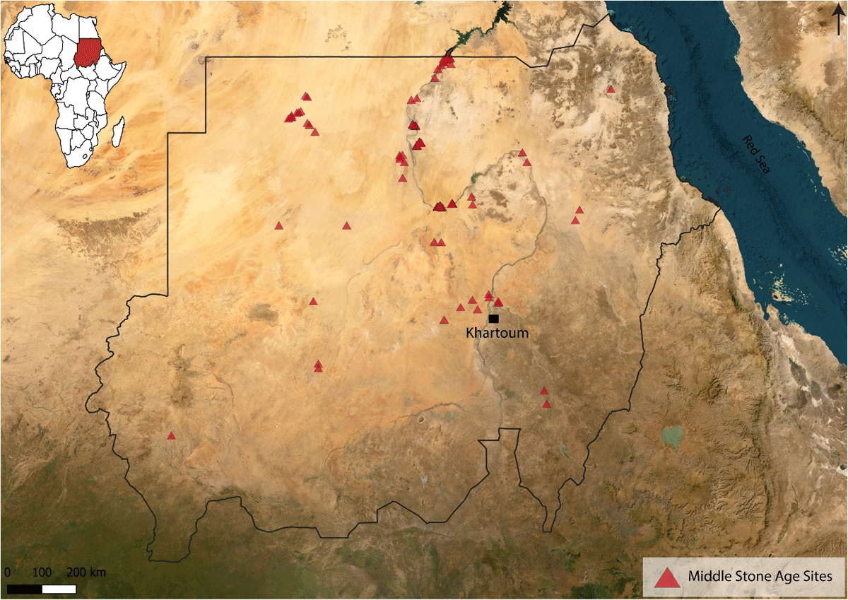
Figure 1
Map showing the location of Middle Stone Age sites in Sudan. Samawi, O.
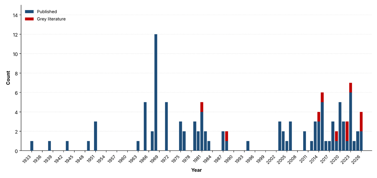
Figure 2
Annual distribution of publications contributing to the Sudanese MSA database.
Table 1
Absolute dates available for Sudanese MSA sites in the SUM database (n = 17), In Sheets SH1 and SH2.
| REGION | TOTAL SITES | DATED |
|---|---|---|
| Abu Hamed Reach | 2 | 0 |
| Bayuda Desert | 3 | 2 |
| Between the Second and Third Cataracts | 16 | 1 |
| Blue Nile Region | 5 | 0 |
| Butana/Eastern Sudan | 3 | 0 |
| Eastern Desert Atbara River Region | 4 | 3 |
| Eastern Kerma Reach | 91 | 2 |
| El-Ga’ab Depression, Western Dongola Reach | 7 | 0 |
| Fourth Cataract Region | 5 | 1 |
| Khartoum Reach | 3 | 1 |
| Northwestern Sudan | 13 | 0 |
| Red Sea Region | 3 | 0 |
| Southern Dongola Reach | 64 | 1 |
| Third Cataract Region | 14 | 0 |
| Wadi Halfa Reach and NE Sahara | 43 | 6 |
| Western Sudan | 7 | 0 |
| Total | 283 | 17 |
Table 2
Inclusion criteria and decision rules applied to site records in SUM.
| CRITERION | CONDITION | DECISION |
|---|---|---|
| MSA attribution | Author(s) identify site as MSA/Middle Palaeolithic/Late Pleistocene | Included |
| Attribution absent, disputed, or site pre-/post-dates this range | Excluded | |
| Location | Coordinates reported by source | Included, flagged High accuracy |
| No coordinates, but site locatable via published/unpublished map | Included, flagged Moderate accuracy | |
| No coordinates and not locatable by any means. | Excluded (not georeferenced) | |
| Technological description | Present | Recorded in full |
| Partial or absent | Retained; field coded NA | |
| Raw material data | Present | Recorded in full |
| Explicitly absent (source states none observed) | Retained; field coded 0 | |
| Not reported (source silent) | Retained; field coded NA |
Table 3
Data structure and format in sheets SH1–SH5.
| COLUMN/FIELD | DATA TYPE | DESCRIPTION |
|---|---|---|
| SHEET OVERVIEW | ||
| SH1 | Raw data | Original technological terminology as recorded in the source publications, 1 = present, 0 = absent, NA = not reported |
| SH2 | Clean data | Core database of standardised site, spatial, chronological, environmental, raw material, and technological variables |
| SH3 | Vocabulary | Definitions of database columns and controlled vocabulary used throughout |
| SH4 | Reference | References used to build the vocabulary, see SH3 |
| SH5 | Reference | References used to build the Sudanese MSA information, see. SH1 and SH2 |
| SITE IDENTIFICATION | ||
| Site name | Text | Official or commonly used designation for a recorded archaeological site in Sudan (geographic location, local place name, or excavation reference number) |
| Period | Text | Chronological attribution as used in the source publication (e.g., “MSA”, “Middle Palaeolithic”, “Late Pleistocene”, “Terminal Pleistocene”). |
| GEOGRAPHIC INFORMATION | ||
| Latitude | Spatial | North–south geographic coordinate in decimal degrees. |
| Longitude | Spatial | East–west geographic coordinate in decimal degrees. |
| Site location accuracy | Categorical | coordinates directly reported by the source. Moderate: derived by georeferencing a published or unpublished site map. |
| Region | Categorical | Broader geographic area within Sudan (e.g., Wadi Halfa Reach, Southern Dongola Reach, Khartoum Reach, etc.) |
| CHRONOLOGICAL DATA | ||
| Age | Numeric range | Radiometric age range (ka) as provided in the literature, or NA if not available. |
| Dating method | Categorical | The dating method(s) from which the radiometric date was obtained (e.g., OSL, U-series, U-Th, C14), or NA. |
| Reliability of Age Estimates | Categorical | Reliable: strong multi-method/stratigraphic support; Partially Reliable: limited by preservation or method; NA: no dating conducted |
| Age Estimate Reliability Criteria | Text | Rationale for reliability classification, based on stratigraphy, context, dating methods, and potential error sources |
| Year of dating | Numerical | Calendar year in which the dating analysis was conducted or published. NA when not reported. |
| SITE CONTEXT | ||
| Collecting Method (CD) | Categorical | Survey/systematic survey/excavation/survey and excavation. |
| Context of discovery (CD) | Categorical | Topographic/geomorphological setting (elevated, low-lying, or water-related landforms); NA if not reported |
| Sedimentary context (CD) | Categorical | Standardised depositional environment (e.g., fluvial, aeolian, colluvial, or mixed combinations); NA if not reported |
| Context integrity (CD) | Categorical | Primary: original depositional position; Secondary: displaced by natural processes; Mixed: both present; NA: not reported |
| Distance to water sources (CD) | Categorical | Proximity to relict (ancient wadi/river/lake features) or modern (current wadi/river/floodplain features) water sources; Undetermined if unclear |
| RAW MATERIALS | ||
| Raw material | Binary (1/0/NA) | Presence/absence of a particular raw materials at the site. |
| Distance to raw material source | Categorical | The proximity of the raw material source to the site, classified as on site, local (c. 1–10 km), imported/exogenous (>10 km), or NA. |
| Preferred raw material | Text | Raw material most consistently selected at a site (e.g., quartzite, chert, flint, sandstone); NA if not reported |
| TECHNOLOGICAL ATTRIBUTES (SH2) — Binary: 1 = present, 0 = absent, NA = not reported | ||
| Modified Pieces | Binary (1/0/NA) | Retouched and modified stone tools (e.g. side scrapers, end scrapers). |
| Levallois related products | Binary (1/0/NA) | Elements produced through the Levallois prepared-core method (e.g. Levallois flakes, Levallois points). |
| Nubian I | Binary (1/0/NA) | Nubian Type I cores and associated products: guiding ridge prepared from the distal end directing removal of a pointed flake. |
| Nubian II | Binary (1/0/NA) | Nubian Type II cores and associated products: preparation removals struck from lateral margins creating a central guiding ridge. |
| Aterian point | Binary (1/0/NA) | Tanged/pedunculated Aterian points: stem produced by hard-hammer percussion at the proximal end; characteristic of the Aterian industry (~145,000–30,000 BP). |
| Non-Levallois related products | Binary (1/0/NA) | Non-Levallois core reduction strategies and their products (e.g. discoidal cores, unipolar cores). |
| Blade related products | Binary (1/0/NA) | Elongated blank production and related elements (e.g. prismatic/tabular cores, volumetric blade cores). |
| Large Cutting Tools (LCTs) | Binary (1/0/NA) | Bifacial and heavy-duty implements (e.g. handaxes, core axes). |
| Points and Projectiles | Binary (1/0/NA) | Pointed tools shaped by retouch (e.g. foliated points, lanceolate tip points, bifacial points). |
| Sangoan technology | Binary (1/0/NA) | MSA industry (~250,000–300,000 BP) named after Sango Bay, Uganda; characterized by thick bifaces, choppers, core scrapers, and picks [40] |
| Lupemban technology | Binary (1/0/NA) | Central African MSA industry adapted to rainforest environment. It comprises elongated lanceolate bifaces, core-axes, and blades. |
| Ambiguous or Unclassifiable Items | Binary (1/0/NA) | Lithic pieces that cannot be confidently classified (e.g. 90-degree cores, struck pieces). |
Table 4
Site location accuracy classifications applied in the Sudanese MSA database, with definitions and analytical suitability. In Sheets SH1 and SH2.
| CATEGORY | DEFINITION | SUITABLE FOR | N (THIS DATASET) |
|---|---|---|---|
| High | Coordinates plot at the documented locality, verified against published maps and Google Earth | Landscape- and local-scale analyses | 263 |
| Moderate | Digitized from georeferenced maps lacking an exact location; coordinates are the nearest reasonable approximation, not a full precise position. | Regional-scale analyses | 20 |
Table 5
Site’s detail per region. In Sheets SH1 and SH2.
| REGION | OPEN-AIR | ROCKSHELTER | DATED |
|---|---|---|---|
| Abu Hamed Reach | 2 | 0 | 0 |
| Bayuda Desert | 3 | 0 | 2 |
| Between the Second and Third Cataracts | 16 | 0 | 1 |
| Blue Nile Region | 5 | 0 | 0 |
| Butana/Eastern Sudan | 3 | 0 | 0 |
| Eastern Desert Atbara River Region | 4 | 0 | 3 |
| Eastern Kerma Reach | 85 | 6 | 2 |
| El-Ga’ab Depression, Western Dongola Reach | 7 | 0 | 0 |
| Fourth Cataract Region | 5 | 0 | 1 |
| Khartoum Reach | 3 | 0 | 1 |
| Northwestern Sudan | 12 | 1 | 0 |
| Red Sea Region | 3 | 0 | 0 |
| Southern Dongola Reach | 64 | 0 | 1 |
| Third Cataract Region | 14 | 0 | 0 |
| Wadi Halfa Reach and NE Sahara | 43 | 0 | 6 |
| Western Sudan | 7 | 0 | 0 |
| Total | 276 | 7 | 17 |