
(1) Overview
Context
Sudan occupies a strategic position in northeastern Africa, linking sub-Saharan Africa, Northern Africa, and the Red Sea regions, while also offering a potential route for expansion through the Nile Valley and Red Sea corridors toward the Levant and Arabia [1, 2, 3, 4, 5]. This location has long been recognized, in many studies, as central to understanding population movements, the transmission of technological traditions, and interactions with different ecological niches [2, 5, 6]. Consequently, the Sudanese MSA provides a crucial comparative framework for examining broader questions of modern human dispersal, cultural innovation, and adaptive strategies in arid, riverine, and coastal environments [2, 4, 7, 8, 9, 10, 11, 12, 20, 21, 22, 23, 25]. Despite this importance, the Sudanese archaeological record remains fragmented: known MSA sites are widely but unevenly scattered across the country (Figure 1), and many are documented only in preliminary reports or gray literature, with limited stratigraphic detail, inconsistent or nonstandard terminology, and variable technological descriptions. Chronological control is particularly weak, as only 17 of the 283 known sites are absolutely dated. Moreover, the use of different dating methods and their uneven distribution across regions make cross-regional comparison difficult. Site integrity is also often compromised by the dominance of surface collections, with relatively few sites benefiting from systematic excavation or geoarchaeological investigation [12, 13, 14, 15, 16].
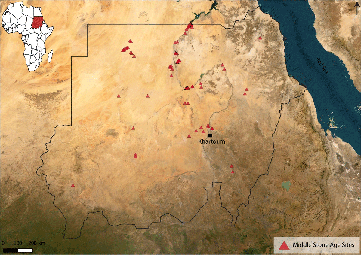
Figure 1
Map showing the location of Middle Stone Age sites in Sudan. Samawi, O.
Against this background, this study aims to make the Sudanese MSA record systematically accessible for future research on population movement and technological transmission. To this end, SUM has been developed as a clean, standardized dataset that integrates geographical, chronological, environmental, and technological information from 283 sites, including regional lithic technological diversity – such as the Nubian Levallois reduction method, raw material procurement strategies, and blade production – together with the environmental and chronological contexts in which these technologies occur. Importantly, SUM includes data from both published studies and the grey literature (see Figure 2), making a substantial portion of the Pleistocene archaeological record of Sudan accessible for the first time. Through a critical assessment of available data and the application of controlled terminology, the database ensures the comparability of different cases and allows for a transparent evaluation of technological diversity and contextual integrity. While recent synthetic contributions have advanced our understanding of the Sudanese and northeastern African MSA record – notably Usai [7], Masojć [17], Leplongeon [9], and Garcea [10]—these works necessarily rely on the published literature and are not structured around systematic primary data. SUM complements and extends these syntheses by providing the first openly accessible, standardized raw dataset for the Sudanese MSA, enabling future researchers to interrogate the primary evidence directly. In doing so, it lays the groundwork for situating Sudan within current debates on Nubian Levallois technology, blade production, raw material strategies, and their implications for models of human dispersal and ecological adaptation.
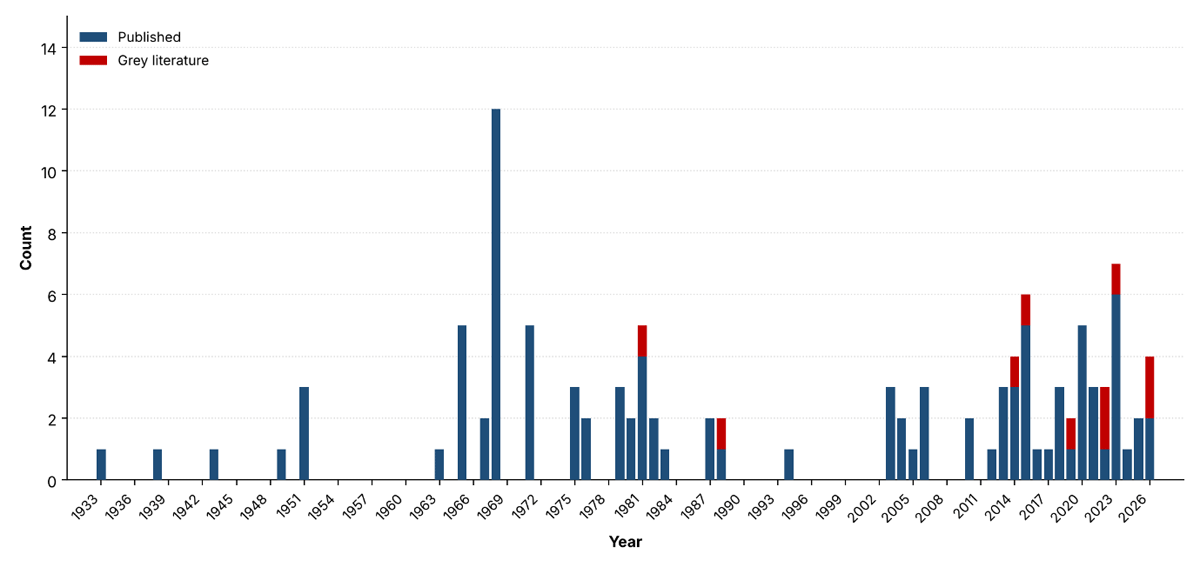
Figure 2
Annual distribution of publications contributing to the Sudanese MSA database.
Dataset Aims
The main aim of this database is to make information on Sudanese MSA sites freely accessible in a structured and reusable format. By integrating spatial, chronological, raw material, and technological data, the dataset provides a comprehensive basis for comparative research at local, regional, and inter-regional scales. A key goal is to ensure transparency by preserving original raw data alongside standardised categories, allowing users to consult primary descriptors and independently verify analytical decisions. The database is designed to support a wide range of applications, including spatial modelling, technological synthesis, chronological frameworks, and assemblage comparisons. By making this resource openly available, it is intended that future research will provide robust evidence for understanding Sudan’s role in debates on human dispersal, technological diversity, and ecological adaptation during the Middle and Late Pleistocene.
Spatial coverage
This dataset presents the distribution of Middle Stone Age sites in Sudan recorded across published and unpublished sources, including peer-reviewed literature, grey literature, and ongoing fieldwork data.
Northern boundary: +22.053775 (Wadi Halfa 34A)
Southern boundary: +12.000000 (Nyertete)
Eastern boundary: +38.040000 (Grar-South 02, Red Sea Region)
Western boundary: +24.100000 (Nyertete)
Nyertete marks both the southern and western limits of the database. Of the 283 entries, 263 have high-accuracy coordinates, while 20 – concentrated among the Sai Island cluster (Between the Second and Third Cataracts), Grar-South 01 and 02 Red Sea Region [26, 42], BP424 and BP1316 Bayuda Desert [41], 3-Q-34, Wadi Umm Rahau HP732, and Hagar Sail HP15 (Fourth Cataract Region) [39, 43].
Temporal coverage
Many of the Sudanese MSA sites are surface occurrences and therefore lack absolute chronology. Only 17 radiometric ages are currently associated with sites in the database, obtained using OSL, U-series, U-Th, and radiocarbon methods. These ages range from a possible MIS 7 context at Sai 8-B-11 (c. 223 ± 19 ka; [12]) to a MSA occupation at HP766 (~21,450 ± 140 uncal BP; [18]). Several of these dates derive from unpublished or forthcoming data, including two sites in the Eastern Kerma Reach (SK7, SK87; ~50 ka [44]), one in the Wadi Halfa area (ANW-3; ~65–62.5 ka [22, 23]; [6, 19]), one in the Southern Dongola Reach (Affad 23; ~58–50 ka [15, 25]), and two in the Bayuda Desert (BP177; 62–17 ka [24], BP424; 59.4 ± 7.3 ka [41]), with further chronological work ongoing at additional Bayuda sites (e.g., BP1316 [41]); as these analyses are formally published, the dataset’s chronological resolution is expected to improve further (see Table 1 for details).
Table 1
Absolute dates available for Sudanese MSA sites in the SUM database (n = 17), In Sheets SH1 and SH2.
| REGION | TOTAL SITES | DATED |
|---|---|---|
| Abu Hamed Reach | 2 | 0 |
| Bayuda Desert | 3 | 2 |
| Between the Second and Third Cataracts | 16 | 1 |
| Blue Nile Region | 5 | 0 |
| Butana/Eastern Sudan | 3 | 0 |
| Eastern Desert Atbara River Region | 4 | 3 |
| Eastern Kerma Reach | 91 | 2 |
| El-Ga’ab Depression, Western Dongola Reach | 7 | 0 |
| Fourth Cataract Region | 5 | 1 |
| Khartoum Reach | 3 | 1 |
| Northwestern Sudan | 13 | 0 |
| Red Sea Region | 3 | 0 |
| Southern Dongola Reach | 64 | 1 |
| Third Cataract Region | 14 | 0 |
| Wadi Halfa Reach and NE Sahara | 43 | 6 |
| Western Sudan | 7 | 0 |
| Total | 283 | 17 |
(2) Methods
Sampling strategy
The sampling strategy for SUM was intentionally inclusive: all Sudanese sites attributed in the bibliography to the MSA, Middle Palaeolithic, or Late Pleistocene were included, with the only condition that a location could be obtained, either from reported coordinates (flagged as high accuracy) or by georeferencing a published or unpublished site map (flagged as moderate accuracy). Full technological descriptions and raw material data were not required; sites with partial, uncertain, or absent information were retained, coded 0 for explicit absence and NA for unreported attributes, to preserve a transparent record of the evidence and its limitations. Table 2 summarizes the inclusion/exclusion logic applied to each record.
Table 2
Inclusion criteria and decision rules applied to site records in SUM.
| CRITERION | CONDITION | DECISION |
|---|---|---|
| MSA attribution | Author(s) identify site as MSA/Middle Palaeolithic/Late Pleistocene | Included |
| Attribution absent, disputed, or site pre-/post-dates this range | Excluded | |
| Location | Coordinates reported by source | Included, flagged High accuracy |
| No coordinates, but site locatable via published/unpublished map | Included, flagged Moderate accuracy | |
| No coordinates and not locatable by any means. | Excluded (not georeferenced) | |
| Technological description | Present | Recorded in full |
| Partial or absent | Retained; field coded NA | |
| Raw material data | Present | Recorded in full |
| Explicitly absent (source states none observed) | Retained; field coded 0 | |
| Not reported (source silent) | Retained; field coded NA |
Steps
The SUM Database was developed in four stages: literature collection, data extraction, data organization and data cleaning.
1. Literature collection
In the first stage, published and grey literature on MSA/Middle Palaeolithic sites in Sudan was identified through Google Scholar keyword searches, citation tracking of known publications, already available databases referencing Middle Stone Age sites such as Hallinan’s database [36], and unpublished material from colleagues who had conducted fieldwork on the topic. Each source was classified by publication status as published or grey literature (see database SH5). This includes unpublished theses, reports and manuscripts. Despite the limitations derived from building an open database from grey literature, information from unpublished sources was retained because it represents most of the information available on Sudanese MSA research.
2. Data extraction
In the second stage, targeted information related to site location, dating method, depositional context and recovery method of the assemblage as well as raw material and techno-typological information was extracted into a raw database (SH1). The main goal was to document technological behavior of MSA groups as well as assessing the reliability of the available data. Unreported fields were recorded as NA, and duplicates were merged, with all sources preserved. This includes conflicting values that were retained with their references to allow independent verification (see data cleaning and quality control).
3. Data organization
In the third stage, raw entries were reorganised into a structured database using key categories: site identification, location, context of discovery, sedimentary context, distance to water sources, chronology, lithic techno-typology and raw material. Lithic terms were kept as reported and matched to their most widely accepted definitions (see SH2) using reference lexicons (Bordes, 1961; Inizan et al., 1999; Shea, 2013), while contextual descriptions were slightly standardised using key words, with full standardisation in SH2.
4. Data cleaning and quality control
The last step consisted in the homogenization of the data to facilitate reuse by grouping synonymous terms into unified categories (SH2,SH3). Where sources conflicted (e.g. dating, coordinates), later revisions, often by the original authors, superseded earlier values; otherwise, the best documented source prevailed or the entry was marked as not reliable.
For lithics, reported terms were grouped into broader classes emphasizing the presence or absence of key elements, such as Levallois and Nubian products, following Bordes and Inizan [37, 38]. Ambiguous cases were discussed jointly and kept as unclassifiable rather than forced into existing types. Coordinates were standardized to decimal degrees, and geological terms describing depositional contexts were discussed with specialists to ensure only equivalent contexts were grouped.
Moreover, dedicated reliability columns recorded the quality of chronological and contextual data and the criteria applied. For chronology, age estimates were rated for reliability; for context, assemblage integrity was rated using explicit criteria defined in the controlled glossary (see SH3).
Limitations
As a database, SUM has several limitations that users should consider when interpreting its contents, especially when drawing regional or temporal conclusions. These limitations are summarized below, together with explicit guidance on how each should inform interpretation of the dataset.
Chronological coverage. Only 17 of 283 sites are absolutely dated, and dating resolution varies; most dated sites are rated Reliable, though 4 are Partially Reliable and 1 is Not Reliable. Guidance: consult the Reliability of Age Estimates field before treating any date as secure, and avoid building regional or temporal narratives on undated or Partially Reliable entries – apparent chronological gaps or clusters may reflect research coverage rather than past occupation patterns.
Grey literature. A substantial share of records derives from unpublished theses, project reports, and archival sources that have not undergone peer review. Guidance: these entries are flagged; users should treat uneven data density across regions as a potential artifact of research and publication intensity rather than genuine settlement variation.
Collection method. Many sites are represented only by surface collections, which lack secure stratigraphic and chronological context and may mix multiple occupation phases. Guidance: users conducting spatial or technological analyses should filter by collection method and treat surface-derived patterns with caution, as they may reflect preservation or collection bias rather than past behaviour.
Data structure
The main database includes various data types, such as spatial coordinates, age ranges, chronological data, raw material records, categorical classifications, and technological attributes (Table 2). It is organized across five sheets: SH1 preserves the original raw data as recorded in the source publications; SH2 contains the standardized, clean data for all variable categories; SH3 provides column definitions and controlled vocabulary; SH4 and SH5 contains the full bibliography. Technological data are organized into two sheets (SH1 and SH2). SH1 records the original terminology used by the authors, while SH2 presents standardized categories, allowing direct comparison between the two. Nubian I, Nubian II, and Aterian points are retained as independent categories in both sheets because of their significance as cultural and dispersal markers. Where data is not available or relevant for a site record, the field is left blank or recorded as NA.
Site location and spatial accuracy
Site coordinates (latitude and longitude) were taken directly from published literature where available and converted to decimal degrees. When coordinate data were not provided, published or unpublished maps and figures were georeferenced against Google Earth satellite imagery to determine site locations [27, 28]. The quality of location data was classified into two categories (Table 4): High, where coordinates were directly reported by the original authors and correspond to the documented site location, suitable for local- and landscape-scale analyses; and Moderate, where coordinates were derived by georeferencing a published or unpublished site map rather than taken from directly reported values, and are therefore best suited to broader regional summaries [26, 42]. When coordinates were identified as erroneous – for example, transposed or clearly misplaced values – the record was corrected where possible or flagged accordingly, with a note documenting the nature of the discrepancy. For each entry, the source used to verify the location and a brief justification for the assigned category are recorded in the database.
Table 3
Data structure and format in sheets SH1–SH5.
| COLUMN/FIELD | DATA TYPE | DESCRIPTION |
|---|---|---|
| SHEET OVERVIEW | ||
| SH1 | Raw data | Original technological terminology as recorded in the source publications, 1 = present, 0 = absent, NA = not reported |
| SH2 | Clean data | Core database of standardised site, spatial, chronological, environmental, raw material, and technological variables |
| SH3 | Vocabulary | Definitions of database columns and controlled vocabulary used throughout |
| SH4 | Reference | References used to build the vocabulary, see SH3 |
| SH5 | Reference | References used to build the Sudanese MSA information, see. SH1 and SH2 |
| SITE IDENTIFICATION | ||
| Site name | Text | Official or commonly used designation for a recorded archaeological site in Sudan (geographic location, local place name, or excavation reference number) |
| Period | Text | Chronological attribution as used in the source publication (e.g., “MSA”, “Middle Palaeolithic”, “Late Pleistocene”, “Terminal Pleistocene”). |
| GEOGRAPHIC INFORMATION | ||
| Latitude | Spatial | North–south geographic coordinate in decimal degrees. |
| Longitude | Spatial | East–west geographic coordinate in decimal degrees. |
| Site location accuracy | Categorical | coordinates directly reported by the source. Moderate: derived by georeferencing a published or unpublished site map. |
| Region | Categorical | Broader geographic area within Sudan (e.g., Wadi Halfa Reach, Southern Dongola Reach, Khartoum Reach, etc.) |
| CHRONOLOGICAL DATA | ||
| Age | Numeric range | Radiometric age range (ka) as provided in the literature, or NA if not available. |
| Dating method | Categorical | The dating method(s) from which the radiometric date was obtained (e.g., OSL, U-series, U-Th, C14), or NA. |
| Reliability of Age Estimates | Categorical | Reliable: strong multi-method/stratigraphic support; Partially Reliable: limited by preservation or method; NA: no dating conducted |
| Age Estimate Reliability Criteria | Text | Rationale for reliability classification, based on stratigraphy, context, dating methods, and potential error sources |
| Year of dating | Numerical | Calendar year in which the dating analysis was conducted or published. NA when not reported. |
| SITE CONTEXT | ||
| Collecting Method (CD) | Categorical | Survey/systematic survey/excavation/survey and excavation. |
| Context of discovery (CD) | Categorical | Topographic/geomorphological setting (elevated, low-lying, or water-related landforms); NA if not reported |
| Sedimentary context (CD) | Categorical | Standardised depositional environment (e.g., fluvial, aeolian, colluvial, or mixed combinations); NA if not reported |
| Context integrity (CD) | Categorical | Primary: original depositional position; Secondary: displaced by natural processes; Mixed: both present; NA: not reported |
| Distance to water sources (CD) | Categorical | Proximity to relict (ancient wadi/river/lake features) or modern (current wadi/river/floodplain features) water sources; Undetermined if unclear |
| RAW MATERIALS | ||
| Raw material | Binary (1/0/NA) | Presence/absence of a particular raw materials at the site. |
| Distance to raw material source | Categorical | The proximity of the raw material source to the site, classified as on site, local (c. 1–10 km), imported/exogenous (>10 km), or NA. |
| Preferred raw material | Text | Raw material most consistently selected at a site (e.g., quartzite, chert, flint, sandstone); NA if not reported |
| TECHNOLOGICAL ATTRIBUTES (SH2) — Binary: 1 = present, 0 = absent, NA = not reported | ||
| Modified Pieces | Binary (1/0/NA) | Retouched and modified stone tools (e.g. side scrapers, end scrapers). |
| Levallois related products | Binary (1/0/NA) | Elements produced through the Levallois prepared-core method (e.g. Levallois flakes, Levallois points). |
| Nubian I | Binary (1/0/NA) | Nubian Type I cores and associated products: guiding ridge prepared from the distal end directing removal of a pointed flake. |
| Nubian II | Binary (1/0/NA) | Nubian Type II cores and associated products: preparation removals struck from lateral margins creating a central guiding ridge. |
| Aterian point | Binary (1/0/NA) | Tanged/pedunculated Aterian points: stem produced by hard-hammer percussion at the proximal end; characteristic of the Aterian industry (~145,000–30,000 BP). |
| Non-Levallois related products | Binary (1/0/NA) | Non-Levallois core reduction strategies and their products (e.g. discoidal cores, unipolar cores). |
| Blade related products | Binary (1/0/NA) | Elongated blank production and related elements (e.g. prismatic/tabular cores, volumetric blade cores). |
| Large Cutting Tools (LCTs) | Binary (1/0/NA) | Bifacial and heavy-duty implements (e.g. handaxes, core axes). |
| Points and Projectiles | Binary (1/0/NA) | Pointed tools shaped by retouch (e.g. foliated points, lanceolate tip points, bifacial points). |
| Sangoan technology | Binary (1/0/NA) | MSA industry (~250,000–300,000 BP) named after Sango Bay, Uganda; characterized by thick bifaces, choppers, core scrapers, and picks [40] |
| Lupemban technology | Binary (1/0/NA) | Central African MSA industry adapted to rainforest environment. It comprises elongated lanceolate bifaces, core-axes, and blades. |
| Ambiguous or Unclassifiable Items | Binary (1/0/NA) | Lithic pieces that cannot be confidently classified (e.g. 90-degree cores, struck pieces). |
Table 4
Site location accuracy classifications applied in the Sudanese MSA database, with definitions and analytical suitability. In Sheets SH1 and SH2.
| CATEGORY | DEFINITION | SUITABLE FOR | N (THIS DATASET) |
|---|---|---|---|
| High | Coordinates plot at the documented locality, verified against published maps and Google Earth | Landscape- and local-scale analyses | 263 |
| Moderate | Digitized from georeferenced maps lacking an exact location; coordinates are the nearest reasonable approximation, not a full precise position. | Regional-scale analyses | 20 |
Site’s details
The database records 276 open-air sites and 7 rockshelters, most represented exclusively by surface material (Table 5). The best-represented regions are the Eastern Kerma Reach (n = 91) and Southern Dongola Reach (n = 64), followed by the Wadi Halfa Reach and Northeastern Sahara (n = 43), Between the Second and Third Cataracts (n = 16), Third Cataract Region (n = 14), and Northwestern Sudan (n = 13). Other regions are represented by only one to seven sites each. This distribution reflects the historical concentration of archaeological research across Sudan rather than the actual density of MSA occupation.
Table 5
Site’s detail per region. In Sheets SH1 and SH2.
| REGION | OPEN-AIR | ROCKSHELTER | DATED |
|---|---|---|---|
| Abu Hamed Reach | 2 | 0 | 0 |
| Bayuda Desert | 3 | 0 | 2 |
| Between the Second and Third Cataracts | 16 | 0 | 1 |
| Blue Nile Region | 5 | 0 | 0 |
| Butana/Eastern Sudan | 3 | 0 | 0 |
| Eastern Desert Atbara River Region | 4 | 0 | 3 |
| Eastern Kerma Reach | 85 | 6 | 2 |
| El-Ga’ab Depression, Western Dongola Reach | 7 | 0 | 0 |
| Fourth Cataract Region | 5 | 0 | 1 |
| Khartoum Reach | 3 | 0 | 1 |
| Northwestern Sudan | 12 | 1 | 0 |
| Red Sea Region | 3 | 0 | 0 |
| Southern Dongola Reach | 64 | 0 | 1 |
| Third Cataract Region | 14 | 0 | 0 |
| Wadi Halfa Reach and NE Sahara | 43 | 0 | 6 |
| Western Sudan | 7 | 0 | 0 |
| Total | 276 | 7 | 17 |
Data sources
The main database includes various data types, such as spatial coordinates, age ranges, chronological data, raw material records, categorical classifications, and technological attributes (Table 3). The database is organized into five sheets. SH1 preserves the original raw data exactly as recorded in the source publications. SH2 contains standardized, cleaned data for all variable categories, used for comparative analysis. SH3 provides the column definitions and controlled vocabulary underlying the standardized categories in SH2. SH4 and SH5 contain the full bibliography, covering the literature used to build the controlled vocabulary and the literature used to compile the site-level data, respectively. Technological data specifically are organized across two sheets (SH1 and SH2), allowing direct comparison between original and standardized terminology. All published sources are listed in full across these sheets, and each site record is individually linked to its primary reference field in SH1 and SH2, so that entries can be traced to their source without cross-referencing SH5. The authors welcome corrections or additions for future versions of the database.
Data Availability
The Sudanese MSA database is deposited on OSF (https://osf.io/z3t62/overview), available in Excel and CSV formats, and licensed under CC BY 4.0. It includes a standardized dataset component for comparative use, accompanied by a terminology and definitions sheet that serves as a codebook/README explaining categories and coding rules. The dataset supports a range of concrete applications. It enables spatial analyses of site distribution, such as mapping the density and clustering of MSA occupations across regions or testing associations between site locations and landscape features (e.g., proximity to relict water sources). It supports technological comparisons between regions, such as contrasting the frequency of Nubian Levallois reduction or Sangoan large cutting tools across the Nile Valley, Bayuda Desert, and Red Sea regions. The dedicated reliability fields allow users to assess or model chronological confidence, for example by weighting or filtering absolute dates according to their assigned reliability rating before constructing regional chronological frameworks. Finally, the standardized spatial and chronological data can be integrated with palaeoclimatic and dispersal-corridor datasets to examine the timing and environmental context of proposed Nile Valley and Red Sea dispersal routes. The dataset is openly licensed for reuse and integration into other resources, provided appropriate acknowledgment is given.
(3) Dataset description
Object name
SUM. Sudan Middle Stone Age Lithic and Contextual Database
SH1. Raw data
SH2. Main database (clean data)
SH3. Column definitions and controlled vocabulary
SH4. Bibliography used to build the vocabulary, see SH3
SH5. Bibliography used to build the Sudanese MSA information, see SH1 and SH2.
Data type
Secondary data compiled from previously published and unpublished (grey) literature, including peer-reviewed publications, unpublished theses, project reports, archival records, and personal communication with active researchers.
Format names and versions
.xlsx and csv
Creation dates
Systematic compilation of the dataset commenced in 2023, with updates throughout 2024 and 2025, culminating in its current version in 2026.
Dataset Creators
Osman Khaleel, Sol Sánchez-Dehesa and Nuno Bicho. All published literature and references consulted in the compilation are provided in full in SH4 and SH5.
Language
English
License
CC-By Attribution 4.0 International
Repository location
The SUM database is permanently archived on the Open Science Framework (OSF) at https://osf.io/z3t62/overview under the title “The Sudan Middle Stone Age Lithic and Contextual Database (SUM): Structure, Research Potential, and Future Directions,” registered under Universidade do Algarve, Portugal (UALG). The dataset is distributed under a CC BY 4.0 Attribution International license in .xlsx and .csv formats, and is accompanied by a README file and a codebook (SH3: Column definitions and controlled vocabulary) documenting all fields, coding conventions, and controlled terminology.
(4) Reuse potential
This dataset represents a step forward in the systematic documentation of Sudanese MSA sites and is intended as a reusable resource for archaeological research. Geolocated sites support spatial analyses of settlement patterns, mobility, and raw-material catchments [29, 30]. Chronological data enable modelling of temporal trends, assessment of chronological confidence across regions, and testing of hypotheses about cultural succession and environmental adaptation [31, 32]. Standardized technological and raw-material categories permit comparative analyses within Sudan and across northeastern Africa, such as mapping the distribution of Nubian Levallois technology to inform debates on human dispersals out of Africa or comparing blade-production strategies between regions to examine technological variability and change [33, 34, 35, 36]. Chronological and environmental fields further support integration with palaeoclimatic records and dispersal-corridor models. By making this resource openly available, the project encourages collaborative reuse and new syntheses of Sudanese prehistory.
Acknowledgements
We are grateful to Universidade do Algarve (UALG); ICArEHB – The Interdisciplinary Center for Archaeology and Evolution of Human Behaviour; the University of Salamanca, Spain; the Department of Archaeology and Folklore, University of Gadarif, Sudan; and the Sudanese National Corporation for Antiquities and Museums (NCAM) for institutional support. The database benefited directly from the publications and raw data of archaeological projects in Sudan, particularly those led by Dr Ahmed Nassr and Prof. Mirosław Masojć (EDAR); Prof. Mirosław Masojć and Michalec (Khor Shambat, EDAR, and Bayuda Desert); Dr Hammad M. Hamdeen (North Elmahas); Dr Yahia Tahir (Al-Ga’ab Depression); Dr Osypińska and Dr Osypiński (Affad in the Latti Basin); Prof. Donatella Usai and Prof. Spinapolice (IsIAO); Philip Van Peer and the French-Belgian mission on Sai Island; Idris (B.O.N.); Amanuel Beyin (Red Sea); Fernández (Blue Nile); Prof. Elena Garcea (Amara West and El-Multaga); Prof. Donatella Usai, Prof. Brigitte Gratien, and colleagues (Zankor and Abou Sofyan); the late J. and G. Guichard; and the late Anthony Marks and colleagues (CPE). Their work provided site-level and contextual information that significantly enriched our dataset.
We warmly acknowledge Dr Emily Hallinan for her generous support and her Nubian Technology “Joad database,” which directly inspired this resource. We thank Mr Osama Samawi for illustrating the MSA sites map, Mr Guillermo Alzate for his input on sedimentological uncertainty, and Dr Vincent Francigny of Sorbonne-Paris and the Sai Island archaeological mission for his generosity and unwavering support. We also thank Sébastien Poudroux (Kheper 3D SFDAS), who relocated missing sites using georeferenced maps; our thanks extend to the SFDAS (Section Française de la Direction des Antiquités du Soudan) for its support; and Dr Shadia Abdrabo and Ms Niama Sabel for their tireless support. We further thank Dr Alice Leplongeon for her valuable comments and the broader community of scholars whose publications form the backbone of this synthesis. This database is conceived as a living resource: it will continue to expand as new fieldwork, publications and unpublished records on the Sudanese MSA become available.
The Open Access fees for this publication were funded by the ERC project DISPERSALS, “Dispersals, Resilience, and Innovation in Late Pleistocene SE Africa” (ERC-2021-ADG, grant agreement No. 101052761), directed by Prof. Nuno Bicho of the Universidade do Algarve.
Author Contributions
Osman Khaleel contributed with the conception of the work, acquisition, analysis and interpretation of data. Sol Sánchez-Dehesa Galán contributed with the conception of the work and reviewing for intellectual content. Nuno Bicho contributed to the reviewing and final approval of the version to be published.