
1. Introduction
Over the past two decades, remote sensing technologies (RST) and the use of lidar-derived (here we use “lidar” as opposed to various other acronyms for “light detection and ranging” (see Deering and Stoker 2014)) products have become widespread on archaeological projects around the world, and yet limited attention has been paid to the ethical concerns of collecting and maintaining these datasets (Fernandez-Diaz et al. 2018). Scholars who work with Big Data in fields such as geography, the digital humanities, and science and technology studies have reflected on many of the issues involved (e.g., Markham, Tiidenberg, and Herman 2018; Pels et al. 2018; Richards and King 2014), but archaeologists must more fully contribute to the conversation (for related scholarship on digital issues, see Bevan 2015; Huggett 2012; Kansa and Kansa 2018; McCoy 2017; Richardson 2018). It is important to point out that the degree of scale and detail, the comprehensive coverage, and the interdisciplinary importance of RST data — and lidar data in particular — make them fundamentally different from other kinds of data conventionally used by archaeologists, and raise a series of quite specific ethical concerns. Since guidelines for ‘best practice’ can offer a useful framework for conducting ethical scientific research, we argue that archaeologists should, therefore, develop a series of best practices and ultimately a code of ethics for collecting, maintaining, and reproducing RST datasets in our work.
In recent years there has been growing concern about the ways in which archaeologists use RST data, and a series of questions have been raised about the ethics of lidar specifically (Begley 2016; Fernandez-Diaz et al. 2018). These issues frame our discussion here and inform other papers in this Special Collection. For example, scientists routinely obtain permits from government officials before collecting remotely sensed data — but when or how do we consult with local communities and stakeholders on the ground? How can RST datasets be integrated into collaborative, community-based archaeological and interdisciplinary research programs? After the data are collected, who has access to the datasets, and where are they housed? How can we use legacy remote datasets to document the rate of cultural heritage destruction and earth systems change? There are very compelling reasons to move towards open access models in our research, but what if these are inconsistent with the desires or interests of certain communities and stakeholders? Given the diversity of the cultural and regulatory contexts in which we routinely work, how can ethical principles be applied globally? Are concerns about sharing location information and looting the same cross-culturally, and to what extent can these concerns be substantiated?
In this paper, we set out to explore these themes, and we suggest a checklist that archaeologists may do well to consider before acquiring remote sensing data, and lidar data specifically. We aim to move towards a code of ethics for archaeological remote sensing, and to encourage careful consideration of research ethics at every stage of the research process. We offer case studies from our work collecting and analyzing airborne laser scanning (ALS) data in Latin America and Southeast Asia (Figure 1), drawing on diverse cultural and environmental contexts to make a case for lidar ethics. Our focus is on airborne lidar, but we anticipate that our discussion should be broadly relevant to other types of RST, including data derived from satellite platforms, UAVs, ground-penetrating radar, photogrammetry, terrestrial laser scanning, and other kinds of geospatial imagery and data.
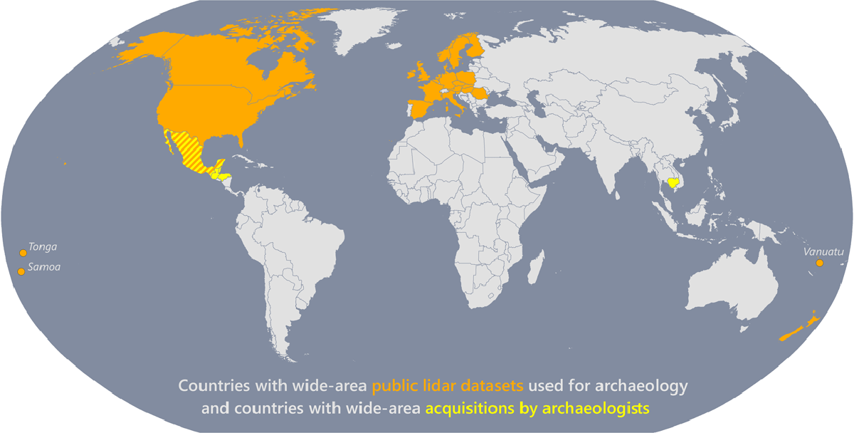
Figure 1
Map of countries for which there are wide-area public lidar datasets used for archaeology and countries with wide-area acquisitions by archaeologists in the peer-reviewed literature (https://angkorlidar.org/bibliography/). We define “wide-area” as >100 km2.
First, we offer a brief overview of ethical codes and guidelines in archaeological research, and how these codes are a relatively recent and Eurocentric development in the discipline. This survey of ethical frameworks in archaeology will be useful for locating our discussion within a broader disciplinary context. We then examine the increasingly widespread use of archaeological lidar and consider how we can learn from recent experiences to improve future work. We highlight three factors that archaeologists should consider before collecting lidar data for archaeological purposes: 1) future access to and dissemination of data; 2) how to engage stakeholders; and 3) how to promote public education. We draw on examples from our own work to illustrate why these kinds of issues should be recognized and considered before embarking on programs of archaeological lidar. Our introductory discussion aims to set the stage for the papers in this Special Collection, all of which, to some degree or another, touch on the issues that we present here. Indeed, what we see is that common questions and concerns emerge from archaeological lidar research worldwide — from contributors working in very different cultural and environmental contexts in Europe, the Americas, Southeast Asia, and beyond — which underscores the need to develop guiding principles to ensure that our research is robust, reliable, ethical, and reproducible.
2. Ethics, Sovereignty, and Airspace
As Smith and Burke (2003) have pointed out, all ethical codes in archaeology were developed within a Eurocentric disciplinary context (see also Lynott and Wylie 1995; Wylie 2002: 229–234, 2003). Apart from the Society for Professional Archaeologists (SOPA, now the U.S. Register for Public Archaeologists) code, which was created in the 1970s, most codes were developed in the 1990s. These developments built on earlier discussion of archaeological ethics, catalyzed in particular by the passage of the United Nations Act of 1985 and the indigenous and Native rights movements around the world in the 1960s–1980s (for historical context, see Davis 1984; Lynott and Wylie 1995; Watkins 2000: Ch. 2). In the U.S., the Native American Graves Protection and Repatriation Act (NAGPRA) in 1990 resulted in substantial debate among archaeologists, Native peoples, and other stakeholders (Atalay 2006, 2012; Trope and Echo-Hawk 1992; Zimmerman 1992) while reburial concerns among Aboriginal Australians have long been an important part of early human archaeology in Australia (Morell 1995; Smith and Jackson 2006). Archaeological ethics codes emphasize some overlapping but also distinctive concerns: the Archaeological Institute of America emphasizes greater understanding of the archaeological record; the Society for American Archaeology emphasizes cultural stewardship; the earlier SOPA code in the U.S., the Canadian Anthropological Association, the World Archaeological Congress, and the Australian Archaeological Association (and the Australian Association for Contract Archaeologists) all emphasize indigenous cultural heritage. Since RST has only been widespread in archaeological fieldwork for a decade or two, there is limited or no explicit mention of using RST in any of these codes.
While this is not the place to provide an exhaustive review of ethical codes, it is worth briefly noting developments in indigenous and community-based archaeology and digital ethics for the purposes of this paper. First, increasing calls for stakeholder and community collaboration in archaeological research have stressed the question of who ‘controls’ the past, or who controls the presentation of the past (e.g., Colwell 2016; Colwell-Chanthaphonh and Ferguson 2010; Morell 1995; Trouillot 1995; Watkins 2000). This can refer to how different communities should be integrated into the broader archaeological research process and/or to the kinds of interpretations about cultural heritage that scholars should consider (Atalay 2006, 2012; Colwell-Chanthaphonh and Ferguson 2010; McNiven 2016; Nicholas 2006; Nicholas and Hollowell 2007; Silliman and Amerind Foundation 2008). Among the many important questions that have been investigated, scholars have examined the extent to which different stakeholders — who may include landowners, government officials, squatters, indigenous peoples, and displaced descendant communities — should share the ability to create authoritative representations of the past. This set of general concerns is directly relevant to our more focused discussion of RST data: who gets to collect, retain, and use the data? These issues arise within many of the archaeological projects that are covered in this Special Collection. Indigenous voices have long been muted or remain neglected or peripheral to archaeological research (Atalay 2006; Watkins 2000), and while there has been some progress on incorporating these voices, there is substantial room for improvement, especially in remote sensing research. We make the case here that engaging diverse stakeholders in our programs, and incorporating the perspectives of indigenous communities, are important pre-requisites for an ethical research agenda involving archaeological lidar.
Also relevant to any discussion of diverse perspectives is the growing dialogue about digital ethics in archaeology. For example, in their study of academic literature about remote sensing, Agapiou and Lysandrou (2015) find that publications and research are clustered at European, North American, and some Asian institutions; meanwhile, other parts of the world like South America and Africa are barely represented (see also Figure 1). This coincides with Bevan’s (2015) point that one outcome of the current growth in digital archaeological information is that existing wealthy, computer-savvy parts of the world are best positioned to generate and exploit digital datasets. Access to the tools and benefits of the geospatial and the lidar “revolutions” are widely uneven, and there is a need to work with local partners in a collaborative effort (Opitz and Herrmann 2018; Rayne et al. 2017; Richardson 2018). In archaeological lidar, uneven access to tools and funding sources has led to a “lidar elite” in some parts of the world, or certain individuals or groups who have the necessary resources to collect, process, and store enormous lidar datasets (Fernandez-Diaz et al. 2018). One potential solution to combat this form of digital colonialism is for fully open access of datasets to ensure data accessibility, sustainability, and longevity (Huggett 2012, 2018; McCoy 2017). As we discuss below, we agree with the idea of open access and appreciate that many archaeological datasets will inevitably be open access soon (if not already), but it is important to recognize that open policies may not be compatible with the wishes of certain countries or communities. Though beyond the scope of this paper, it is worth pointing out that accessibility and privilege, in general, are broader problems within institutional (i.e., academic, government) archaeology and the discipline itself.
2.1. Airspace and Regulations
One set of issues that has a slightly deeper historical context than archaeological ethics revolves around airspace and sovereignty. Some of the earliest concern with regulating access to airspace was in eighteenth-century France, where authorities in Paris responded to the advent of scenic balloon flights by outlawing it except with special permission from the police department (Haney 2015: 7). With the rapid development of aircraft technology in the first decades of the twentieth century, European and North American countries agreed that nation-states held sovereign rights to airspace above national lands and territorial waters (Haanappel 2003; Reynolds and Merges 2019: Ch. 2). In the years that followed, countries worldwide developed legal frameworks for regulating airspace; the United States, for example, passed the Air Commerce Act in 1926 and the Federal Aviation Act in 1958 for safety, and even states and local governments have the power to enact aviation regulations that do not conflict with federal aviation laws. In the United States, indigenous sovereignty over airspace is a complex issue. Native American nations are under Congressional power, which means that state laws are inapplicable against tribes unless authorized by Congress. However, some Native American constitutions state that all waters and airspace within Indian nations fall within the jurisdiction of tribe (Haney 2015:19). These overlapping and sometimes ambiguous claims are of relevance as scientists and archaeologists increasingly use airborne data throughout the U.S. and elsewhere.
A related issue arises with urbanization, agricultural expansion, illegal logging and clearing, and the use of public lands for resource exploitation in the U.S., Central America, and parts of Southeast Asia. One of the main applications of airborne lidar is for geological mapping for oil, gas, and mineral exploration, frequently in protected or relatively pristine wilderness areas, which raises obvious ethical questions about the participation of archaeologists in the industry. On the other hand, we recognize that the surface of the landscape is an irreplaceable archive of past human activity, and that increasing destruction — driven in part by events such as flooding, fires, and tsunamis whose frequency and intensity is increased by climate change — provides one of many powerful incentives to document these landscapes before they are lost (see Fernandez-Diaz and Cohen, in press).
In the years since archaeological codes of ethics and guidelines were developed between the 1970s and 1990s, the scale and detail of remote sensing data has increased dramatically, alongside the degree of connectedness between individuals and communities over vast scales of space. In 1991, the World Wide Web was two years old, and in 1995, just 0.4% of the global population accessed the internet (Bing 2009; Ryan 2010). The Multispectral Scanner (MSS) sensor onboard of Landsat 5 satellite was producing publicly accessible images with a resolution of 60 m per pixel. Prototype airborne lidar sensors have existed since at least 1985, but they did not have the capability to penetrate thick vegetation canopies, and they produced low-resolution data that was of limited use to archaeologists (Sheets 1991). Today, on the other hand, up to 54% of the global population has access to the internet, and the public has free access to worldwide imagery at 30 m resolution or higher in urban areas (ITU, United Nations 2019). Lidar data enables researchers to visualize archaeological features that are concealed under forest canopies, and to map hundreds or thousands of square kilometers in a short time with sub-meter spatial resolution. Embedded in these Big Data — which are increasingly publicly available — are elements of the archaeological record, which can be used for both the preservation and destruction of cultural resources. This compels us to think carefully about ethical issues and the potential abuse of data and their accessibility. Unforeseen misuse and unintended consequences are part of the potential of information in the public domain. For now, because of concerns over looting, there are significant barriers to accessing high–resolution archaeological lidar data. Nevertheless, as Chase and Chase (2017) have observed, there is an urgency to develop a systematic and coordinated approach to dealing with the consequences of open lidar data, since technological developments point towards the increasing, easy availability of ever-more high-resolution lidar datasets in the future.
2.2. Lidar and Archaeology
The use of very detailed, wide-area topographic datasets has a long history in some regions, such as parts of Europe, the Andes, and Mesoamerica, and for some archaeological projects today they are a key, foundational resource (Alcock and Cherry 2016; Balkansky 2006; Billman and Feinman 1999; Leisz 2013; Sanders, Parsons and Santley 1979). At the landscape scale, lidar has transformed how we collect topographic information in terms of speed, accuracy, and resolution. Topographic relief models made from lidar have been used to great effect in forested or heavily-vegetated areas where ground survey, and other forms of RST, are slower or less effective (Brady, Barton and Seaver 2013; Canuto et al. 2018; Chase et al. 2012; Evans et al. 2013; Rosenswig et al. 2013). Importantly, lidar products can be used alongside traditional ground-based approaches, including pedestrian survey, to facilitate refined research questions regarding heritage management and settlement patterns.
The degree to which lidar data have been a part of the archaeological toolkit varies according to region. Over two decades ago, European archaeologists began to incorporate ALS acquisitions into projects of landscape archaeology and heritage management, coinciding with growing policy interest in landscapes and sustainability at national and European Union scales (e.g., Bewley, Crutchley, and Shell 2005; Campana 2017; Opitz 2016; Opitz and Limp 2015; Turner 2006). Institutional drivers from the European Union and the Malta Convention (European Council 1992) played a key role in bringing ALS into heritage management realms within European archaeology (for recent examples in this collection, see Cowley et al., in prep; Doneus et al. in press; Nuninger et al., in press). Approximately ten years ago, other parts of the world began to catch up with their European colleagues. In Mexico and Central America, lidar scans are changing the way that we think about urbanism, population sizes, and settlement patterns (Canuto et al. 2018; Chase et al. 2011, 2016; Fernandez-Diaz et al. 2018; Fisher et al. 2016, 2017; Garrison, Houston and Alcover Firpi 2019; Hare, Masson and Russell 2014; Inomata et al. 2018). In South America, lidar data have the potential to transform the way that we think about and preserve vast areas of the Amazon Basin (Iriarte et al., in prep; Khan, Aragão and Iriarte 2017; Stenborg, Schaan and Figueiredo 2018). Ongoing work at early urban centers in Cambodia, notably in the Angkor region, is also contributing to new insights into urban planning, water management, and landscape engineering in heavily forested settings (Chevance et al. 2019; Evans et al. 2013; Evans and Fletcher 2015; Klassen, Weed and Evans 2018). In sum, archaeological lidar has moved well beyond making beautiful image products and improving survey techniques, and we argue that the time has, therefore, come to systematically confront the ethical concerns that have been raised.
3. Ethics in Archaeological Lidar
Here we identify three issues that scholars wishing to collect lidar data should consider. We do not list these issues in any order, and some may be more relevant to certain situations than others. Ultimately, however, we hope that this will serve as a foundation for a code of conduct or series of research ethics in archaeological lidar that may be extended to other applications of RST in archaeological research.
3.1. Accessibility and Dissemination
Archaeological lidar projects differ in their data access policies, with many groups opting to erect significant barriers to access, and yet there is an increasing trend worldwide towards open access for geospatial data (Bevan 2015; Huggett 2012; McCoy 2017). In this context, from the earliest stages of project design, researchers should develop an access strategy that identifies who will be working with the information and where it will be stored. Because existing archaeological guidelines and ethical codes derive from experiences with traditional field archaeology, they often refer to contexts that are at the scale of the site, architectural feature, or artifact. Yet, remote sensing enables us to study ancient phenomenon at the scale of the landscape or region. This brings a unique set of challenges, particularly with respect to curation and data management. Who curates these Big Data? Who can access them? Who decides who disseminates the research? What, if any, are the limitations or boundaries for collecting data?
Remotely sensed datasets ensure the preservation of the archeological record, and yet the datasets can be enormous — which in turn creates different kinds of preservation problems. In the case of the Mosquitia region in Honduras, our inventory of high-density, three-dimensional point cloud data includes 144 km2 of ALS data, terrestrial lidar scans from before and during excavation, and 3D models of groundstone artifacts (Cruz-Castillo 2015; Fernandez-Diaz et al. 2018; Fisher et al. 2016). These storage issues are in addition to conventional archaeological data such as artifacts, photographs, field notes, and so on. Other projects have larger collections still: the Cambodian lidar programs have accumulated more than 2000 km2 of high-density point coverage, consisting of around forty billion individual measurements (Evans 2016) — and this project, in turn, is dwarfed by recent acquisitions in Guatemala, which seek to cover 15,000 km2 (Canuto et al. 2018; Estrada-Belli pers comm.). That archaeologists would be commissioning three-dimensional datasets of such scale and detail was practically unimaginable only a decade ago. To cope with such developments, scholars have called for more sustainable database management (Chase and Chase 2017; Huggett 2018; Kansa and Kansa 2018; McCoy 2017; Richards-Rissetto and von Schwerin 2017), and there are now numerous repositories that we can use, such as the Digital Archaeological Record (tDAR), Open Science Framework (OSF), Box, and GitHub. At some institutions, such as in Europe, there are ‘in-house’ university-managed networked and backed-up servers: in the UK, there is the project-funded Archaeological Data Service, and in the Netherlands, there is the DANS (Data Archiving and Networked Services)-Easy archiving system for large dataset storage. For the time being, however, there remains only one dedicated global repository for high-resolution topographic data, OpenTopography. Depending on the project, some of these services may be too expensive or grant dependent (e.g., tDAR; Box), and others may eventually start charging fees (e.g., OSF). GitHub has a relatively steep technical cost of entry, but it is free and open access — one useful outcome is that everyone who works on a GitHub project ends up with a copy of code on his or her own computers. Even in the spirit of open access, this may not be appropriate for all projects and it may not adhere to the wishes of host countries with specific access policies (see discussions in Bevan 2015; Opitz and Herrmann 2018).
While there may be no catchall solution for data storage, questions of sustainable access to datasets should be a central concern at the planning stage for archaeological lidar programs — well before data collection — and applications for grants and permits should have appropriate budgets to facilitate this, in addition to laying out comprehensive data management plans. A major concern in these plans should be keeping datasets up to date with current software, and the recognition that future storage systems may be incompatible with our contemporary instruments. Storing data is not a one-time process; rather, as case studies from Croatia (Doneus et al., in press) and Honduras (Fernandez-Diaz and Cohen, in press) show, the raw data must be preserved and then updated and integrated as technology changes.
Questions about openness and accessibility are closely related to and profoundly complicated by concerns about safeguarding the cultural features revealed by lidar technology. On the one hand, awareness of the existence and location of heritage resources is crucial for their effective conservation, and increased accessibility to lidar data sets the stage for a broader range of stakeholders to become involved in that effort. On the other hand, do higher resolution maps promote looting? The longstanding assumption for many areas is that they do, or at least that they might, but there have been few systematic studies that evaluate the idea (Frank et al. 2015; Krieger 2014). This is something that needs to be a focus of study, perhaps beginning by looking at whether the availability of free, high-resolution imagery in Google Earth and Google Maps has had a net positive or negative impact on heritage conservation (see Myers 2010; Ur 2006). Recognizing that withholding geospatial data from communities of end-users is also a source of potential harm to heritage resources, we should better involve local partners in projects (see below) and begin to carefully weigh the risks in specific locations instead of defaulting to locking away datasets.
There is an urgency to make lidar data more widely available for planning and decision-making. In some areas — such as the ancient city of Angamuco (250–1530 CE) in Western Mexico, and the Honduran Mosquitia — our archaeological lidar scans may be the last records of ancient landscapes that will soon succumb to development, their archives of past activity erased forever. Soon after our 2011 and 2015 lidar scans of Angamuco (Fisher et al. 2017; Fisher and Leisz 2013), a new toll road was built on the southern side of the site (Figure 2). While the road does not go directly through Angamuco, the construction project has irreversibly changed areas around the site, adversely affecting our ability to study past environmental conditions and resource exchange between the ancient city and its hinterlands. Parts of our acquisition area in the Honduran Mosquitia were clearcut for development in the years between our planning phase in 2009 and our airborne acquisition in 2012, and a section of the surface archaeological record was thus permanently erased. In that case, we were too late, but since we have scanned the other 144 km2, we at least have a permanent record of archaeological sites and the broader ecological landscape (Figure 3).
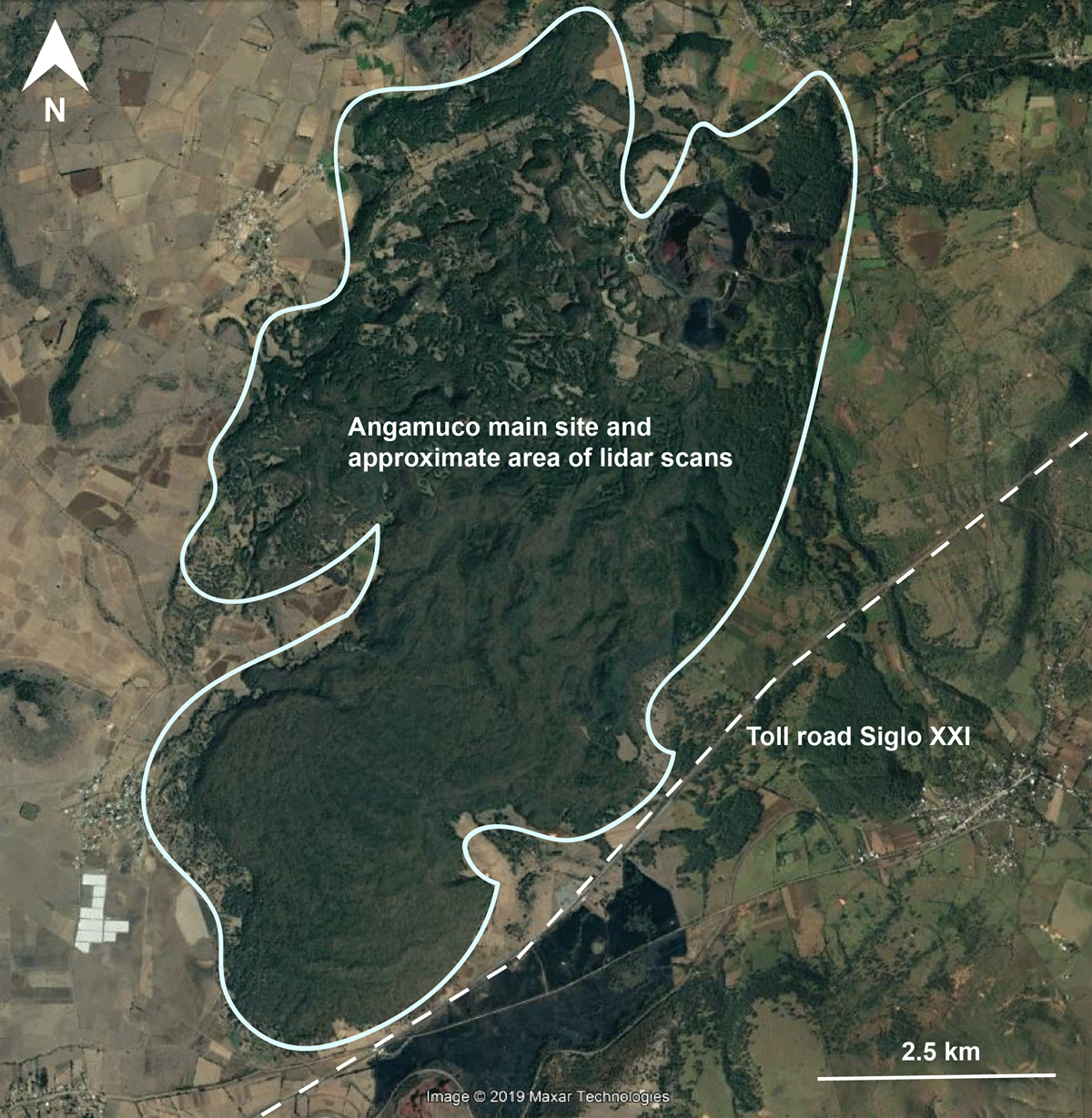
Figure 2
Map showing the location of the toll road (Auto Siglo XII) that was constructed after we had completed lidar scans of the ancient city of Angamuco, Mexico. While the toll road does not go through the heart of the site and architecture, the construction activities and modified landscape impact archaeologists’ abilities to interpret the hinterlands around the site.
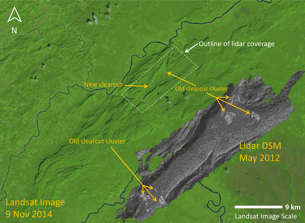
Figure 3
Image of clearcut in the Mosquitia region of Honduras that is visible in a lidar-derived Digital Surface Model (DSM). Arrows point to clearcut that had occurred prior to the lidar scans, and another example of deforestation that occurred after our scans. Lidar data were collected in May 2012. Base map is a Landsat 8 image collected 9 Nov 2014. Modified from image by Juan Carlos Fernández-Diaz.
Our first scans in Cambodia were in 2012, at a time when many of the archaeological zones were remote, inaccessible, and poorly-served by infrastructure. In the years since then, archaeological authorities have used lidar-derived maps to intervene in several cases where road-building work threatened the integrity of the archaeological features revealed by lidar. At the tenth-century CE Angkorian capital of Koh Ker, for example, a project by the concession-holder to widen and pave the dirt road that facilitates access to the site’s temples was dramatically scaled back in 2013 after a last-minute intervention by authorities newly in possession of the lidar data. The planned works would have destroyed several features of archaeological interest, including remnants of occupation areas associated with the temples, which had not yet been documented (Figure 4). To this day, the paved highway to Koh Ker stops several kilometers from the main complexes, and access to the temples remains by way of the original, narrow dirt road. Similar interventions against road works in sensitive archaeological zones have also taken place recently in Phnom Kulen, in the north of the Angkor region, where another early capital remains substantially hidden beneath the forest (Chevance et al. 2019; Jean-Baptiste Chevance pers. comm.). In all these cases, adverse outcomes were prevented by last-minute, ad hoc interventions by government archaeologists who happened to have privileged access to tightly controlled, closed archives of lidar data. Efforts are now underway to open those archives, improve access to the lidar data for all stakeholders, and engage communities in planning processes informed by the imagery, with a view to improving conservation outcomes.
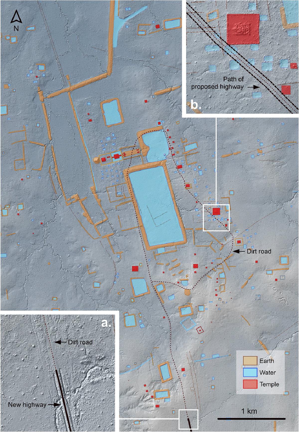
Figure 4
Archaeological map of Koh Ker, in Cambodia, including a lidar hillshade/elevation composite and showing (a) where work was halted on the highway system; and (b) features that were under threat of destruction from the road works. Map data by Sarah Klassen and Damian Evans.
There is no denying that looting remains a legitimate concern in many regions where archaeologists work (e.g., Casana and Panahipour 2014; Matsuda 1998; Stone 2008) and that lidar data may conceivably be used for inappropriate or even illegal purposes. It may well be that looters will obtain and use high-resolution lidar maps because of our research programs, and perhaps the maps will encourage casual visitors who will negatively impact archaeological sites in other ways. Nonetheless, it is perhaps time to consider whether the tangible and immediate risks of losing cultural heritage due to natural and human-made disasters outweigh the theoretical risks associated with data accessibility. Paradoxically, our experience in places like Cambodia suggests that our efforts to protect sites from harm by closing data off to looters may increase the harm caused to them from other kinds of processes and have a net negative impact overall. It is important to acknowledge that we cannot possibly protect all archaeological sites and that our current efforts to prevent looting and destruction appear to be substantially ineffective in many areas (see discussion in Chase et al., in press). A way forward may be to encourage archaeological projects to re-assess their views on data availability, and to make certain maps accessible so that we can engage a broader range of stakeholders and communities as allies in our efforts to identify and preserve cultural heritage.
To what extent should corporate interests be involved in this process? We have already noted that one of the main drivers behind wide-area lidar acquisitions is exploration geology for extractive industries, and engagement with that sector raises a series of obvious ethical concerns, particularly in countries with weak rule of law and poor environmental protections. Notably, funding of archaeological lidar acquisitions by private concerns may be presented as a rationale for decreased accessibility to the data. This is an issue in the Americas, which have a much stronger tradition of private philanthropy than other parts of the world, and where the largest archaeological lidar acquisitions have all been funded by private foundations. This contrasts with publicly-funded acquisitions, which may be subject to mandates for public accessibility — in other words, making the data available to the taxpayers who funded the acquisition. Nevertheless, even with public funding, there are various regulations about whether government entities retain or control access to lidar data, which makes it difficult to establish a universal protocol for data sharing. There are numerous technical, financial, political, cultural, religious, privacy, and safety reasons why it may only be possible to complete an aerial laser scanning campaign over important cultural heritage sites once and once only. Furthermore, and as we have noted, this may eventually form the only remaining archive of landscape elements that are subsequently erased. Ultimately, this provides a compelling rationale for managing access to privately funded acquisitions on the same terms as publicly-funded datasets, which is to say, for making them as open and accessible as we possibly can.
3.2. Integrating the Concerns of Stakeholders
Closely related to questions of accessibility are questions of who benefits from lidar, and who does not. Remote sensing techniques, even active systems such as like airborne lidar, are non-destructive and non-invasive (at least in the way that archaeologists typically understand those terms): no ground is broken, no material is disturbed, there is no destruction of the vegetation, and there is no immediate or measurable harm to local inhabitants. The data are typically used to help local or national authorities to refine or expand their heritage inventories and to improve research and management plans. Archaeologists and heritage managers are the immediate beneficiaries, but there are wide ranges of very significant social and economic benefits that can flow from the increased spatial awareness. As we have noted above, there are also a range of potentially adverse outcomes; meanwhile, the benefits of lidar may be spread unevenly. That being the case, how should we as researchers engage with all the groups who are potentially impacted, ranging from local stakeholders (including local landowners, indigenous groups, and marginalized groups such as squatters) to powerful national interests such as government authorities? Recognizing that lidar data might encode the only permanent record of threatened cultural and natural heritage in each area, how might descendant communities be given a voice in the acquisition and stewardship of that information? It is important to note that there may be divergent perspectives on how to promote the protection of cultural heritage, even within individual ‘communities’ (e.g. Cohen and Solinis-Casparius 2017; González-Ruibal 2009; Leighton 2016; McClanahan 2007; Meskell 2005; Pyburn 2011; Richardson and Almansa-Sánchez 2015). Meanwhile, government authorities will naturally seek to establish and impose a specific regulatory framework, and archaeologists must, of course, respect and operate within those constraints. Some regulations indicate that cultural patrimony belongs to the entire nation rather than a specific community, and difficulties will arise where certain groups of people — including those that are vulnerable or disadvantaged, such as indigenous groups — do not consider programs of wide-area scanning to be in their best interests. How can we respect and promote these rights while following regulations? What are the implications of working with authoritarian regimes as we deploy the tools of the modern surveillance state to scan citizens and their homes, in incredible detail, and in three dimensions? There are no easy answers to any of these questions, and we do not propose any solutions here. It will be sufficient to point out, for the time being, that our archaeological understanding of techniques like lidar as being ‘non-destructive’ and ‘non-invasive’ is deeply problematic on a number of other levels, which must be taken into account as we develop programs of archaeological lidar (or, indeed, decline to do so).
There is also a range of complex issues surrounding ownership of the results of lidar programs, and to whom we should attribute knowledge or insights about elements of cultural or natural heritage, especially where there are shared or even competing claims to patrimony. Our experience in Honduras highlights how there is a need to balance the respect for identities and oral history with scientific remote sensing data and interpretations. As discussed below, oral histories and other forms of “unofficial” knowledge in Honduras like rituals and community are sometimes considered differently from more “official” scientific data or written historical accounts (compare with Scott 1990; Trouillot 1995). Elsewhere, scholars have demonstrated that balancing traditional local knowledge with various kinds of scientific data can enrich both empirical observations and subsequent interpretations (e.g., Chapin, Lamb and Threlkeld 2005; Colwell-Chanthaphonh and Ferguson 2010; Green, Green and Neves 2003; Hayes 2010). Importantly, the geographical distribution of sites in eastern Honduras is much larger than the current distribution of indigenous groups in what are now very specific regions, which means that descendant communities may live far away from the places that their ancestors inhabited (Stone 1957; Tauli-Corpuz 2016). This is largely due to European colonial policies that led to forced relocation and environmental factors during and after European contact (Davidson 1991; Lanza et al. 1992). How do we navigate these oftentimes-fragile connections between descendant communities, modern residents, and contemporary and historic landscapes, and whom should we integrate into our discussions?
As Begley (2016) points out, overlapping or differing connections to cultural heritage and landscapes may be irrelevant for archaeologists, because archaeologists and non-indigenous peoples are obscured by their own expectations of sites, significance, and meaning. For example, in Honduras, indigenous Pech and Tawakha groups have specific links to the cultural heritage of the Mosquitia region that can be unique from one another. This includes an oral tradition about a lost city called Wahia-Patatahua or Kao Kamasa (which roughly means “Place of the Ancestors” or “White House” in Pech; or La Ciudad Blanca in Spanish) (Begley 2016; Herlihy 1997; Lara-Pinto and Hasemann 1991). Versions of the lost city narrative sometimes include depictions of white buildings deep in the Mosquitia jungle, a place hidden from Spanish colonizers where deities and indigenous peoples could live safely (Lara-Pinto and Hasemann 1991). Other Spanish versions persist in modern Honduran society — that of a hidden wealthy society in Honduras that may date to Friar Pedraza, a priest who wrote about large settlements in the Mosquitia soon after arrival in the region (Pedraza 1892). These views may be marginalized by archaeologists, however, because we often lack diverse perspectives and understanding of local, indigenous knowledge (see Atalay 2012; Begley 2016; Colwell-Chanthaphonh and Ferguson 2010; Leighton 2016; Meskell 2005; Sheehan and Lilley 2008; Watkins 2000).
Yet, when versions of this “lost city” narrative were recently popularized in U.S. and Honduran press accounts, there was a backlash by some archaeologists who are critical of the idea of “lost” cities. In some ways, this was understandable because professional archaeologists dislike the implication that sites are to be “discovered” by modern-day explorers. Most unfortunately, indigenous voices were peripheral in the popular “lost city” accounts, which meant that indigenous perspectives on local oral traditions were largely ignored. Given this multiplicity of sometimes conflicting narratives, and acknowledging that archaeologists might find “lost city” tropes problematic, would it be neglectful to omit the narrative from discussions of cultural heritage in eastern Honduras? At the very least, the lesson from the Honduras case is that multiple stakeholders should have worked together to promote both the scientific and cultural narratives, that indigenous voices in particular should have been prioritized.
We have had to navigate similar issues in our work in Cambodia, in which sensational narratives about “lost cities” have come to dominate media coverage of findings from archaeological lidar, despite considerable efforts by project members to counter them and add nuance to the public discussion (Evans 2013). Particularly troubling in the Cambodian context are the racist and colonialist implications of these “lost city” narratives, which ignore the fact that the temple-cities of the Angkor period have never been abandoned by the Khmer people who built them, and in fact, show evidence of continuous habitation from prehistory to the present day (Coe and Evans 2018). It has been widely acknowledged for at least a century that the monuments of Angkor were civic-ceremonial buildings at the epicenter of urban complexes, even if the exact form of those cities has been a subject of debate. The temple-cities of greater Angkor are also immensely important national icons, and the sense of shared history that they underpin lies at the very heart of Cambodian nationhood. These settlements were never “lost” or “abandoned” by Cambodians, and were thus never “discovered” by anyone, much less by teams led by foreign archaeologists. Nonetheless, the “lost city” trope is remarkably resilient in public discourse on lidar work in Cambodia and has overwhelmed alternative narratives of the past presented by archaeologists and local communities alike. It also speaks to a wider problem of public perception of our lidar work, which lies at the intersection of fantasies about exploration and discovery, and excitement about high-tech applications of lasers in the jungle. All of this is profoundly at odds with our desire to come to terms with legacies of colonialism in our discipline and suggests that we have a long and difficult road ahead in amplifying marginalized voices promoting alternatives to these kinds of narratives.
3.3. Public Education
As the public is educated about scientific methods and becomes increasingly interested in the outcome of archaeological lidar work, it is clear that we must be more responsible about modes of dissemination and the clarity of what is learned (Klein et al. 2018). We advocate for democratizing archaeological science, and the datasets it produces, as an important part of achieving responsible and proportional representation in the media. Additionally, as scientists, we need to do a better job of communicating our work to the public. This is not only because the public often funds our projects and consumes our data and interpretations in various ways, but because non-scientists in media, political, or religious contexts may promote pseudo-scientific claims (Feder 2014; Holly 2015). How can we promote our research and findings? Certainly, blogs, public talks, documentaries, and teaching are important; what else can we do to democratize science in an ethical manner that reaches people in diverse environments? We have already mentioned our difficulties in shaping the public narrative in the context of our work in Cambodia. Throughout the course of our Mosquitia projects in Honduras, some of the news article headlines created by journalists were equally hyperbolic. While we may not like all phrases used by journalists, phrases such as “lost city” ensure that many non-archaeologists and scientists read about the Mosquitia region. We may not approve of all the ways that academic archaeologists interact with the public, but decreased engagement with science journalism will be counter-productive in any number of ways.
In the rapidly-changing media environment, it can be difficult or even impossible to control the ethical dissemination of archaeological remote sensing data, and yet we can identify a few points for consideration. It is critical that the initial release of results in the media coincides with the release of a peer-reviewed publication, in order to promote informed points of view and balance hype and sensationalism. We can accompany media releases with lists of experts who have been given advance copies of the material, with a view to promoting knowledgeable discussion and highlighting underrepresented voices. Before agreeing to work with certain journalists, it can be useful to ask whether researchers will be able to review articles before dissemination; this may not be possible due to editorial policies, but it is worth checking since it provides an avenue for proactively correcting errors and misinterpretations. Careful consideration should be given to how research teams want the research portrayed, and the role of various stakeholders in this portrayal. Depending on the context, researchers should work with local stakeholders and invite them to participate in the media portrayal (if interested); alternatively, journalists could be encouraged to reach out to local collaborators. Ultimately, though, we must recognize that documentaries, including “scientific programming” in venues like National Geographic and the BBC, and even science journalism is for a broader, non-archaeological public. We can be careful about what we say or do while on the record, but we should acknowledge that words may be taken out of context and/or used to tell a story.
While there may be little we can do to prevent inappropriate phrases, we still believe that we should collaborate with well-meaning journalists. We should develop media strategies on all archaeology projects that go beyond a webpage or an official Twitter handle. Academic institutions and private companies may have their own public relations offices, but each archaeological project should have a designated person to speak with the media as well. This person should discuss interpretations with the larger research team and develop a strategy for how lidar projects are promoted (for an example, see http://dissertationreviews.org/archives/6672). This is especially important for those of us who work with foreign governments so that we can respect their own promotional policies.
An encouraging outcome of public interest and lidar archaeology is the potential for a democratizing effect in the collection and dissemination of spatial data such as lidar products. Technical decision-making can incorporate multiple levels of expertise (Collins and Evans 2002). For example, crowd-sourcing efforts and so-called “citizen science” have long been used in fields such as Astronomy and Biology, and even in community-engaged archaeology, but this kind of approach is a more recent development in remote sensing archaeology. The definition of citizen science is broad, but it essentially refers to volunteer (non-professional) citizen researchers helping with a scientific project. Large-scale citizen science remote sensing projects include the Global Xplorer program, which has harnessed over 66,000 volunteers to interact with satellite images and identify instances of looting (Yates 2018), and the crowdsourced search for Genghis Khan’s tomb by National Geographic in Mongolia (Lin et al. 2014). While there are questions about the reproducibility and quality of these data points, these kinds of projects show the potential for directly involving citizens in the collection and/or interpretations of large datasets. Recent examples of a citizen science approach in archaeological lidar are encouraging, including the use of lidar hillshades in the undergraduate classroom in France (Forest et al. 2020) and a machine-learning and citizen researcher fieldwork campaign in The Netherlands (Lambers, Verschoof-van der Vaart and Bourgeois 2019). These studies demonstrate that there is unexplored pedagogical potential in lidar data. In the future, participatory archaeology – which incorporates community perspectives, including potential research questions about approaching wide-area spatial data – may play a future role in democratizing archaeological lidar.
4. Conclusions
In this paper, we maintain that there are several ethical issues that archaeological lidar project must address and that we should create an ethical code to navigate such projects. We argue that, in one way or another, archaeological lidar projects must address issues of data access, the role of stakeholders, and public education. Our case studies in the Americas and Southeast Asia show that these issues are best addressed well before data acquisition. The purpose of this article is to illustrate how the different themes that we discuss are transversal, crosscutting a geographic range of projects, with differing scales and objectives. We are encouraged by papers that touch upon some of the issues that we discuss here (Chase and Chase 2017; Corsi, Slapšak and Vermeulen 2013; Fernandez-Diaz et al. 2018; McCoy 2017; Opitz 2016; Opitz and Herrmann 2018; Richardson 2018), and yet we believe that specialists in archaeological lidar can more fully contribute to and develop the conversation about research ethics.
As the evolving considerations about database management, stakeholder collaboration, and archaeological ethics show, aspects of some of these ethical quandaries in archaeological lidar may vary according to context and they will likely change over time as this subfield matures. Our experiences and those of our colleagues underscore that archaeological lidar and RST projects encompass far too much diversity in aims and methods to consider rigid protocols. Nonetheless, we believe that archaeologists who want to collect these types of data must engage in a reflexive, holistic process of preparation that weighs the opportunities and challenges of integrating such kinds of data. Ethical guidelines, found in most scientific communities, are an important step for considering such reflexive conversations. As a professional community that will continue to use large remote datasets, we should establish specific ethical guidelines to ensure reproducible scientific data that are collected, stored, and interpreted in a manner that aligns with professional practice. We hope to encourage our colleagues to be mindful about the issues highlighted here, and to start incorporating these and related questions into archaeological lidar research moving forward.
Acknowledgements
This article stems from conversations in recent years while in the field and with our colleagues at conferences, invited talks, and via email. The papers in this Special Collection derive in part from conversations at the Paris Dialogue on Archaeological Lidar, a workshop held at the École française d’Extrême-Orient in December 2018 and funded by the European Research Council (ERC) under the European Union’s Horizon 2020 research and innovation programme (grant agreement No 639828), and co-organized by the authors and Christophe Pottier. All workshop participants provided important insight into our discussions concerning archaeological lidar and best practices. The first author has been developing some of these ideas with input from Juan Carlos Fernández-Diaz, and she additionally acknowledges the help of Alicia González. We would like to thank the many colleagues and stakeholders who we have met during our respective research projects in Latin America and Southeast Asia. In Mexico, we acknowledge the Fontezuelas ejido community, the Tzintzuntzan heritage community council, INAH Michoacán, and the LORE-LPB research team. In Honduras, we thank IHAH, Under the Lidar, the Honduran Special Forces, National Geographic, and the MAP research team. In Cambodia, we acknowledge the partners of the Khmer Archaeology Lidar Consortium and the Cambodian Archaeological Lidar Initiative, and are especially grateful to our Cambodian colleagues and local communities on the ground for their ongoing collaboration in our research programs. We acknowledge the useful comments of two reviewers for improving the quality of this paper.
Competing Interests
The authors have no competing interests to declare.