
Introduction
The global adoption of agricultural commercialization has historically been lauded for its enhancement of production efficiency. However, concerns have also been raised regarding its detrimental impact on diverse landscapes, which can be attributed primarily to the intensive land management practices (Abson et al., 2013; Rusch et al., 2016). Over recent decades, landscape simplification – described as the loss of multifunctional, cultural agroecosystems and the expansion of monofunctional, intensive croplands (Riechers et al., 2021) – has become a widespread phenomenon. This trend has profoundly disrupted the intricate interplay between ecosystems and society inherent in cultural landscapes. While existing studies predominantly emphasize the biophysical dimensions of these interactions, such as threats to biodiversity from habitat loss and to soil and water quality due to the overuse of chemicals (Green et al., 2005; Riechers et al., 2020; Tscharntke et al., 2005), they have paid little attention to the pivotal social dimension, which is the main force shaping landscapes. Institutions and governance systems formed in societies are considered to be a direct driver of transformation in natural systems, and stand as a pertinent yet understudied aspect that is crucial for comprehending global sustainability challenges (Mastrángelo et al., 2019).
The conceptualization of landscapes as “landscape commons” offers a lens through which to comprehend the intricate interplay between institutional dynamics and landscape simplification (Menatti, 2017). Landscapes, as composite entities, embody diverse spatial characteristics and land uses shaped by competing claims and requirements (Görg, 2007). Through interactions among multiple actors and natural or socio-economic processes (Graaf et al., 2017; Menatti, 2017), landscapes acquire the nature of commons, thereby becoming subjects of collective management and institutionalization. These institutions, consisting of both formal and informal rules, represent cultural frameworks for interpreting landscapes (Quinn et al., 2007). The institutions involved in governing landscape commons emphasize the preservation and transformation of the multi-function and biophysical characteristics of landscapes, and are closely related to the customs, equity, and values of the local people (Gerber & Hess, 2017; Plieninger et al., 2023; Vialatte et al., 2019). However, amidst the process of landscape change, institutions are also influenced by external socioeconomic shifts, and conflicts can arise among stakeholders involved in managing landscape commons, in which specific values and functions are stressed while others are ignored, consequently exerting pressure on landscapes (Bürgi et al., 2017; Evans et al., 2008; Ford et al., 2020).
While studies have acknowledged the role of institutions in driving landscape change (Evans et al., 2008; Ford et al., 2020), there remains a notable gap regarding comprehensive institutional analyses within specific types of landscape commons, as the way in which the system works–and thus how it should be analyzed–depends on its unique socioeconomic context and resource attributes (Ostrom, 2007a). To address this gap, exploring cases of landscape simplification in holistic and multifunctional social-ecological system contexts can enrich the realm of commons research by providing higher-resolution insights and contributing localized knowledge which is crucial for understanding landscape sustainability from an institutional standpoint.
The current investigation zooms in on a distinct category of landscape commons that is understudied and often marginalized in social-ecological studies – pond landscapes– which are undergoing rapid expansion and concurrent simplification due to commercialization. Pond landscapes are characterized by small freshwater bodies distributed in an area that, while also providing a broad suite of ecosystem services such as water retention, outdoor recreation, and religious values (Bekefi & Varadi, 2007; Blayac et al., 2014; Botlíková, 2021), is primarily exploited for fish farming (Sarrazin et al., 2022; Francová et al., 2019). The commercialization of aquaculture within these landscapes is marked by the utilization of advanced technologies, increased reliance on external inputs such as feed and chemicals, and alterations of the landscape’s natural hydrology to meet commercial demands (Aubin et al., 2019; Palash et al., 2018). This process has challenged the efficacy of local institutions in managing these landscapes, in aspects including the maintenance of physical structures, distribution of resources, and monitoring of the inputs and outputs of fish farming (Chowdhury & Behera, 2022; Joffre et al., 2018). Exploring the intricate relationship between institutional dynamics, alterations in aquaculture practices, and the subsequent changes in biophysical dimensions within these contexts remains a critical yet largely unexplored avenue of research.
This study examines the institutional arrangements surrounding pond landscapes, with an emphasis on their linkages with landscape simplification. The Pearl River Delta is situated in South China, one of the most rapidly urbanizing areas in the world, and represents a unique case for the study of pond landscapes, wherein the “dike-pond system” is faced with ecological and social challenges brought about by landscape simplification. The objectives of the study are as follows:
To elucidate the institutional arrangements concerning the dike-pond system in the context of commercialization;
To explore the landscape simplification process occurring in the dike-pond system;
To reveal the linkages between landscape simplification and institutional arrangements in the dike-pond system.
This study endeavors to offer a comprehensive case study examining the governance of holistic and multi-functional landscape commons, expanding the scope of the previous commons research. The insights derived from this case study hold the potential to offer valuable guidance for policymaking and the establishment of organizational structures for handling landscape simplification challenges across diverse landscape commons worldwide.
The management of the dike-pond system: A conceptual framework
Ostrom’s Institutional Analysis and Development (IAD) framework is applied to study the local management of the dike-pond system (cf. Figure 1). The IAD framework serves as a guiding tool, bridging the operational level, where actors engage in resource-management decisions, and the collective choice level, where decisions are shaped by established rules (Ostrom, 2007a; Cole et al., 2019). In this framework, the “action arena” is the core arena, which is composed of an action situation and actors. The action situation represents a social space where actors interact to solve common problems and make choices that determine the outcomes of resource management, and actors are those who are involved in the situation (Nigussie et al., 2018; Ostrom, 2007b).
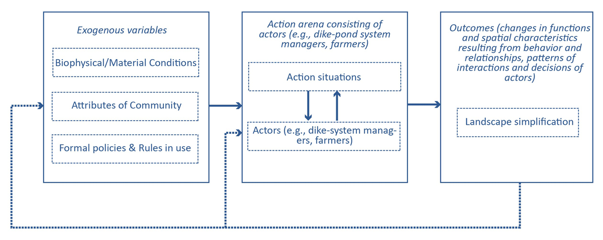
Figure 1
Theoretical framework for assessing the dike-pond system management (Adapted from Ostrom, 2007a; Brodrechtova et al., 2018; Chowdhury & Behera, 2022).
This study operates on the premise that the action situation, which in this case is the physical space of the dike-pond system, plays a pivotal role in shaping management practices, and uses the IAD framework as a lens to analyze and understand the dynamics at play. Regarding pond landscape management, actors refer to all people who have a direct or indirect influence on the management outcomes (Brodrechtova et al., 2018), such as dike-pond system managers and farmers engaged in fish farming. The interactions and collective actions of the actors are determined by their values, interests, and customs, as well as exogenous factors (Ostrom, 2005).
A range of exogenous components in the dike-pond system structure the action situation (cf. Figure 1): biophysical conditions; community attributes, like the socio-economic structure of the users and managers; as well as rules (i.e., social institutions), which define how an action situation works in a landscape system (Polski and Ostrom 2017). In the Pearl River Delta, the most influential factor in the management of the dike-pond system has been changes in community attributes, namely the commercialization of agriculture driven by the Chinese economic reform (“reform and opening-up”), which transformed the collective economy that was strictly controlled by the government into a market economy (Liu, 2020). The process stemmed from alterations in the land system, empowering farmers with greater autonomy in production decisions and allowing them to select agricultural products based on market demands, and shifts in agricultural product policies, which saw the government relinquishing its stringent control over product types and prices (Lin, 1992; Lele & Goswami 2020). As a result, the community livelihood mode changed from a small-scale, limited community economy to a market economy.
Further, there are several types of rules for how the actors in the action situation interact with the landscape, which can be formal (e.g., laws) or informal (e.g., shared beliefs). Actors in the dike-pond system interact among themselves and produce outcomes, which loop back into the system to exert an effect. For instance, farmers cultivate fish, which narrows the dike’s width—an outcome of biophysical conditions. Other exogenous components of the biophysical characteristics of the pond landscape are their multifunctionality and their contributions to water and soil quality (Gongfu, 1990). The biophysical conditions affect the action arena due to the strong livelihood dependence of the local people on the dike-pond system, as diverse farming choices are offered through the different biophysical elements, for example crop cultivation or poultry farming on the dikes and aquaculture in the ponds.
The action arena, which is influenced by exogenous variables, ultimately determines outcomes, most notably landscape simplification. Changes in the landscapes in turn influence peoples’ connectedness with nature and the management practices (Riechers et al., 2021), thus highlighting landscape simplification as both an outcome and a driver of landscape management. This study seeks to analyze the collective processes and outcomes within the dike-pond system management regime, examining the intricate dynamics that shape landscape changes.
Ostrom’s Design Principles were applied as the conceptual framework to make qualitative assessments on each design principle appeared to operate in the management of the dike-pond system. Design Principles (DPs) are “an essential element or condition that helps to account for the success of these institutions in sustaining the [common-pool resource] and gaining the compliance of generation after generation of appropriators to the rules in use” (Ostrom 1990, p90). Detailed descriptions of the DPs are listed in Table 1. Ostrom’s DPs have been recognized as a standard for evaluating the robustness of community management institutions, after having been verified in hundreds of cases (Cox et al., 2010; Quinn et al., 2007; Dell’Angelo et al., 2016). They have proven useful in analyzing the connection between the collective action/choice and operational levels, as well as the dynamics of social and biophysical variables. It has been pointed out that the congruence of local institutions with Ostrom’s DPs is positively correlated with the ability of the system to achieve its goals in the long term (Cox et al., 2010).
Table 1
Descriptions of Ostrom’s Design Principles (DPs) (Ostrom 1990).
| DESIGN PRINCIPLES (DPs) | DESCRIPTION |
|---|---|
| 1. Clearly defined boundaries | Individuals or households who have rights to withdraw resource units from the common pool resource (CPR) must be clearly defined, as must the boundaries of the CPR itself. |
| 2. Congruence between appropriation and provision rules and local conditions | Appropriation rules restricting time, place, technology, and/or quantity of resource units are related to local conditions and to provision rules requiring labor, material, and/or money. |
| 3. Collective-choice arrangements | Most individuals affected by the operational rules can participate in modifying the operational rules. |
| 4. Monitoring | Monitors who actively audit CPR conditions and appropriator behavior are accountable to the appropriators or are the appropriators. |
| 5. Graduated sanctions | Appropriators who violate operational rules are likely to be subjected to graduated sanctions (depending on the seriousness and context of the offense) by other appropriators, by officials accountable to the appropriators, or by both. |
| 6. Conflict-resolution mechanisms | Appropriators and their officials have rapid access to low-cost local arenas to resolve conflicts among appropriators or between appropriators and officials. |
| 7. Minimal recognition of rights to organize | The rights of appropriators to devise their own institutions are not challenged by external governmental authorities. |
| 8. Nested enterprises | Appropriation, provision, monitoring, enforcement, conflict resolution, and governance activities are organized in multiple layers of nested enterprises. |
Methods
Study area
The dike-pond systems studied are situated in the alluvial plains of the Pearl River Delta (PRD) in China, where there is a dense river network (cf. Figure 2). Characterized by a subtropical monsoon climate, this area is warm and rainy, with annual temperatures ranging from 14 °C and 29 °C and annual precipitation of around 1700 mm. The monsoon season spans from April to September. The dike-pond system in the Pearl River Delta has a history of more than 600 years (Wong et al., 2004). The landscape was sustained in an integrated way in the past, wherein the ponds were used for fishing and the dike was used for growing grass as a feed source or for cultivating crops, thus giving rise to the name “dike-pond system” (Lo, 1996).
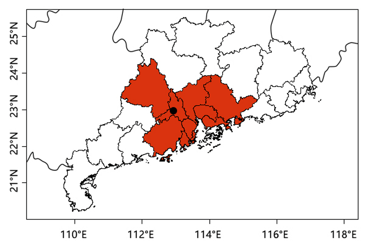
Figure 2
Location of the study area in the Pearl River Delta (The red color indicates the Pearl River Delta area and the black dot indicates the location of the study area).
Ruxi village, an administrative village located at the core of the collectively managed dike-pond system in the region was selected as our case study area. Twenty-one (21) joint-equity economic cooperatives (hereafter referred to simply as “cooperatives”) involved in this village are the basic resource management organizations. Cooperatives served as the production units before the reform and opening-up, assigning production tasks to farmers and monitoring production activities directly. However, with the gradual transformation of the land system, wherein production autonomy was gradually allocated to farmers, the cooperative became an economic organization primarily tasked with managing collective assets and distributing income among cooperative members.
In 2020, there were 7,289 inhabitants in Ruxi village. The whole area spans approximately 960 ha, of which more than one-third are the dike-pond system, and the rest is mainly settlements, arable land, rural factories, and forests. The majority of this area is part of a national-level “Important Agricultural Heritage System” (Ministry of Agriculture and Rural Affairs, PRC, 2019), a recognition of its unique landscape features and the related culture. The 21 cooperatives have similar social-ecological conditions and the same governance structure in resource management. The management portfolio created by these cooperatives is thus representative of the collectively-managed dike-pond system in the wider area.
Data collection
Data was collected using a semi-structured interview guideline. The guideline comprised sections on the presence of certain institutional arrangements in the community regarding the management of the dike-pond system, involving boundaries set inside the system, requirements of appropriation, monitoring and punishment, conflicts and solutions existing in the current management, as well as the decision-making process for the system’s rules. Additionally, we asked respondents about their perceptions of landscape changes in the last 40 years (since the reform) to extract the landscape simplification process through qualitative interviews. The interview concluded with questions about the respondent’s personal vision of a ‘good’ landscape and the potential for institutional improvements (See Appendix).
For the selection of the interviewees, we identified cooperative members from three groups: 1) farmers managing at least one pond; 2) cooperative managers who are active in pond management; 3) staff from the administrative village. It was possible for a single interviewee to correspond to more than one group. We first chose cooperatives with a high degree of dependence on the dike-pond system. Snowball sampling was used to identify other cooperatives, and this approach eventually resulted in 17 interviews in eight cooperatives. We examined the saturation of the interviews to make sure they generated sufficient information for providing an in-depth overall understanding of the management regime of the dike-pond system. Before each interview, verbal informed consent was obtained from each interviewee. The interviews lasted between 40 and 90 minutes, and were conducted either in-person or by phone.
Data analysis
Data was transcribed literally and analyzed with the qualitative data analysis software MaxQDA (2020). The coding step sought to capture the interlinkages between institutions, the dike-pond system and landscape simplification processes. In the first step, a deductive coding process was applied according to the existence of a clear relation to the DPs, which helped to focus on the topics involved in the management regimes. In the subsequent inductive approach, new codes were successively grouped together to form categories and provide a systematic interpretation of Ostrom’s Design Principles in the context of the dike-pond system.
To assess the linkages between landscape simplification and institutional arrangements, the interview transcripts were first coded through an inductive approach to catch all aspects of landscape simplification, and then subsequently developed into themes. Next, underpinning codes were linked with each other. For example, we may have coded “high input of artificial feed” as one aspect of landscape simplification, and this aspect is related to “insufficient monitoring of productivity”. During the review and coding of the transcripts, the interlinkages between institutions were also examined. All individual linkages were then collated together to form a linkage network, which identified linkages between different institutions as well as between institutions and landscape simplification processes.
Results
Overview
The cooperatives are decentralized, financially autonomous associations that self-govern the dike-pond system, with guidance of the government at the town level and Ruxi village at the administrative village level, particularly in administrative affairs, finance management, and policy enforcement (cf. Figure 3). The fish farming rights in the dike-pond system are leased to farmers (including cooperative members and external members). All cooperative members are entitled to receive dividends from collective income and to participate in decision-making processes relating to collective affairs.
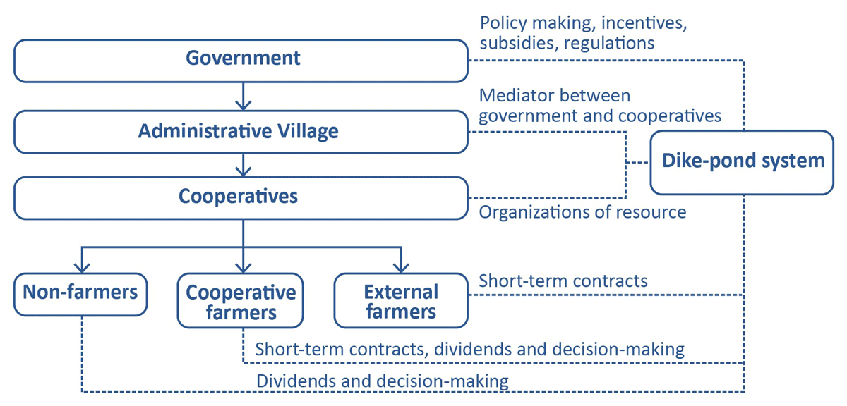
Figure 3
Overview of the governance setting of the dike-pond system.
Each cooperative consists of around 200 to 650 members, corresponding to 60 to 200 families with 3–4 members in each family. Approximately 10%–25% of the families engage in fish farming by renting ponds from the cooperatives during periodic pond leasehold meetings held every five years. Some cooperatives also allow non-cooperative members to access the ponds; these farmers are not involved in decision-making processes. The main motivation of the cooperatives for pond leasing is to achieve monetary benefits. The cooperatives are responsible for maintaining the collective infrastructure (cf. Table 2). Fish farming is a significant investment for farmers, offering high profits but also high economic risk. This situation creates a strong financial dependence on ponds for farmers. Typically, each family manages two to three fish ponds, with one to two laborers being involved in fish farming practices.
Table 2
Characterization of the cooperatives in Ruxi village, 2020.
| VARIABLE | SITUATION IN THE COOPERATIVES |
|---|---|
| Average pond area of a single cooperative (excluding the dike area, which is not counted) | 19.5 ha |
| Average area of a single pond | 0.3 ha |
| Average rent (per ha/year) | 7180 € |
| Average number of members | 342 (ranging from 200 to 650) |
| Members’ link to fish farming | Members are strongly dependent on intensive fish farming |
| Motivation of management | Monetary benefits; maintaining resource conditions |
| Attributes of fish species | High-value species: catfish, eel, largemouth bass |
| Ownership of farming equipment | Machinery, fish, and facility built by farmers are private property; infrastructure built by cooperatives and government (such as channels, electric facilities, sheds) are common property |
| Use of collective profits | Most gains are divided among cooperative members; joint investments are made for maintaining resources |
| Legal form | Cooperatives |
Analysis of institutional arrangements according to Ostrom’s Design Principles
DP1: Clearly defined boundaries
The definition of physical boundaries operates at two distinct levels, namely the cooperative level and the farmer level. At the cooperative level, physical demarcations are meticulously established, primarily concerning cooperative-owned assets like ponds, lands encompassing dikes, and infrastructure erected by the cooperatives, such as ditches serving specific ponds. Ponds and lands are the core important components of the cooperative assets, and the spatial boundaries between one another are clearly defined with the help of government, ensuring clarity and management efficiency. However, distinctions are less clear for elements like rivers and roads, which are utilized by multiple cooperatives. All cooperatives can use the roads and rivers freely, depending on their needs in relation to fish farming, and without the need to set boundaries. There are two main reasons for this. First, the ponds and related infrastructure belonging to the different cooperatives are scattered and intermixed. Further, the roads were built through cooperation between cooperatives after commercialization, on land belonging to different cooperatives.
At the individual level, physical boundaries are established in the middle of the dikes by the cooperatives; these can be adjusted through verbal negotiations between farmers. The flexibility of dike boundary reflects a trend where the significance of the dikes diminishes amid a context increasingly inclined towards commercial aquaculture. Notably, individual farmers are allowed to make modifications to pond areas as long as they don’t affect neighboring users, allowing a degree of flexibility within the individual domain.
User boundaries are delineated at two hierarchical tiers within cooperatives, namely contracted farmers and all cooperative members. Contracted farmers secure fish farming rights under term agreements, currently set at five years, but which are subject to adjustments based on production demands. Meanwhile, all cooperative members, who benefit from annual dividends tied to collective income, indirectly partake in the monetary benefits generated from these resources.
From the above analysis, the existence of clear physical boundaries is evidenced only in relation to the resources with clear ownership that have a direct influence on collective income. Besides, boundaries on resource withdrawal rights are also established in relation to the magnitude of monetary benefits, aiming to ensure their equitable distribution is met as it pertains to the magnitude of monetary benefits and their equitable distribution.
DP2: Congruence between appropriation and provision rules and local conditions
In the study area, provision and appropriation activities as well as local conditions include monetary transactions related to ponds, infrastructure maintenance, fish farming, ecological conditions, and the dependence of local people on fish farming. This DP is thus observed concerning pond use but not in the case of dikes and rivers.
Regarding pond utilization and facilities, congruence operates at both the farmer and cooperative member levels. Monetary payments made by farmers serve as provisions to appropriate fish farming rights. However, the traditional provision through collective labor has ceased due to land system reforms in the Pearl River Delta and the reinforcement of social division attributable to agricultural commercialization. Notably, varying payments, ranging from 2,525 €/ha to 15,930 €/ha, correspond to better ecological conditions, such as water source quality and soil conditions. Social conditions also factor into the congruence, influencing decisions like permitting outsiders to rent ponds based on the livelihood dependency of cooperative members on fish farming.
Congruence extends to cooperative members (both farmers and non-farmers), as they all act as appropriators of the dike-pond system by sharing the collective income from leasing the ponds out and also by contributing to maintenance fees for infrastructure such as electricity facilities and ditches and roads close to the cooperative’s ponds.
However, the situation is different concerning dikes and rivers. In the context of commercialization, ponds hold a comparative advantage over other resources, leading to the determination of rent based solely on pond area, excluding dikes. Dikes, which are assigned to contracted farmers for free, serve purposes of transportation and vegetable cultivation. Contrarily, the responsibility for river maintenance, including water regulation and waste cleanup, is rarely assumed by cooperatives, despite rivers being the primary source of freshwater for fish farming.
DP3: Collective choice arrangement
This principle is exhibited in the dike-pond system as cooperative members, including both farmers and non-farmers, are allowed to participate in decision-making processes. In the Pearl River Delta, the collective-choice institutions – cooperatives – are clearly defined in statutes. The cooperative committee, elected by community members, holds executive power and proposes important issues concerning the dike-pond system, such as resource redistribution plans and land-use suggestions according to economic development. Decision-making occurs at different levels according to the scale. First, decisions concerning smaller or localized areas in the dike-pond system, such as day-to-day maintenance of infrastructure, happen at the cooperative committee level. Second, decisions concerning medium-sized areas are made at the cooperative representative level (ten non-committee members). Last, decisions concerning large areas (such as periodical pond re-leasing or land-use layout plans) are made through cooperative meetings involving all cooperative members. Once decisions are made, they are documented in the contract, with some informal rules publicly acknowledged; for example, in certain cooperatives, farmers are allowed to transfer ponds to others.
Based on the information collected, the conditions for collective choice generally exist in the dike-pond system.
DP4: Monitoring
The data revealed partial adherence to monitoring, notably concerning the use of aquaculture drugs in fish farming and changes in land use, while the dike-pond system generally lacked formal monitoring of appropriation behaviors and resource conditions.
Government agencies are responsible for monitoring the use of aquaculture drugs and land use change, but these strategies began in the 2000s. The monitoring activities include regular spot-checks of water quality, documentation of aquaculture drug use by individual farmers, and fish quality inspections before they are sold. Administrative village staff assist in monitoring compliance with government regulations.
However, formal monitoring is lacking for appropriation behaviors and resource conditions, with the system relying instead on voluntary efforts by cooperative managers and reports from members. This approach has limitations. For instance, amidst increasing virus outbreaks due to intensive management, some farmers dispose of dead fish into rivers without adequate scrutiny or monitoring, highlighting the absence of effective oversight mechanisms.
DP5: Graduated sanctions
Institutionalized graduated sanctions exhibited alignment with monitoring rules, particularly concerning the use of aquaculture drugs, yet diverged when it came to appropriation behaviors. Government-imposed sanctions govern aquaculture drug usage, with administrative villages holding minimal authority in this domain. These regulations were established concurrently with monitoring protocols. During spot-checks, farmers initially receive warnings regarding water quality issues, which can escalate to severe sanctions, including penalties or administrative measures, for persistent poor water quality. In extreme cases, individuals caught using illicit aquaculture drugs have faced imprisonment for extended periods.
However, concerning appropriation behaviors and resource conditions, most violations prompted only verbal warnings. Cooperative managers cite difficulties in sanctioning cooperative members due to robust social relations, with many improper behaviors not warranting punitive actions. For instance, despite widespread mention of issues regarding the disposal of dead fish, no punitive measures have been enforced, reflecting a reluctance to impose sanctions for such behaviors within the cooperative setting.
DP6: Conflict-resolution mechanisms
Conflict-resolution mechanisms are present informally among the farmers, but not between farmers and cooperatives or government. At the individual farmer level within the commercialization context, conflicts are infrequent as farmers operate independently without significant interference in each other’s activities. Occasional disputes, primarily regarding dike boundaries or road usage, typically find resolution through internal cooperation among members. For example, if one farmer transgresses the boundary of the ponds, or destroys another’s vegetables unintentionally, other cooperative members or the cooperative managers will act as mediators to seek mutual understanding between the two sides, either privately or by informal meetings. In cases where conflicts escalate beyond internal resolution, involving administrative village staff as external mediators becomes the next course of action.
Conflicts also arise between farmers and cooperatives or government when the cooperatives or government want to occupy part of the dikes for resource maintenance or construction. Despite the dike areas not being considered in rental calculations, most farmers are opposed to occupation of the dikes by cooperatives or government unless they obtain some financial compensation. Usually, the conflicts end with the cooperatives or the government giving up on the plan. For example, the rivers are not well maintained as the cooperatives are not allowed to use the dikes for silt storage or biodiversity maintenance, resulting in river degradation and dike abandonment. This discord often persists without resolution, leading to sustained tensions, such as distrust between farmers and cooperatives, difficulties in policy implementation, and impasses among the parties involved.
DP7: Minimal recognition of rights to organize
Cooperatives retain their rights to self-organize, for example concerning when and to whom to lease the dike-pond system and the price and rules for paying the rent. However, the level of autonomy is constrained by the administrative village and government authorities, which impose environmental regulations and official procedures. Cooperatives enjoyed a high degree of autonomy in the dike-pond system management from the 1980s to the 1990s, as the there was no strict monitoring of agricultural lands. Since the 2000s, cooperative resource management plans have been required to align with government guidelines and receive government approval. For instance, the cooperatives’ plans for leasing the dike-pond system are formulated based on an outline provided by the government, and the plan needs to be approved by the government. This affects management by the cooperatives to some extent, but the ultimate decision-making rights over resource management remains at the cooperative level.
For example, in one instance the government wished to install a wastewater purification system in the ponds of one cooperative, but it was voted against by most cooperative members due to its potential negative effects on short-term livelihoods and collective benefits. As a result, the final plan was not executed, highlighting the cooperative’s ability to make decisions concerning resource management based on their specific circumstances and priorities.
DP8: Nested enterprises
The management of the dike-pond system is divided into three levels: cooperatives, administrative village, and the government. This organizational structure was only put in place in the 2000s. The cooperatives play a central role in resource operation and maintenance. The administrative village acts as a mediator, assisting with financial audits for cooperatives, document archiving, and policy enforcement between cooperatives and government.
In the 1980s to 1990s, government-level management was lacking. For example, there was an absence of agricultural land-use control after the cancellation of the mandatory rice cultivation policy in the 1980s. Since the 2000s, multiple government sectors have gradually become involved in the dike-pond system management. At present, the agricultural and rural departments of the local government take the lead in formulating management policies, for aspects such as the building of infrastructure or regulation of the use of aquaculture drugs. The financial sector provides funds for policy enforcement, with amounts varying per policy. For example, an incentive of 1,005 €/ha was provided to encourage farmers to maintain the ponds in 2018. However, most incentives have been short-term. Currently, the government is planning to transform all ponds into regularized shapes, and 4,020 €/ha is set as the standard funding amount. Further, the power, water conservancy, and natural resources departments of the local government are respectively responsible for power infrastructure, dredging the river, and auditing land use. Conflicts may arise between different departments. For example, strict land-use controls from the natural resources department would hinder the agricultural and rural departments from developing other industries like tourism due to restrictions on infrastructure construction.
Process of landscape simplification of the dike-pond system
Two main aspects of landscape simplification were observed in the study area: simplification of land cover and monoculture.
Historically, the landscape was characterized by a mix of ponds and croplands, as shown in the 1980’s aerial photography (cf. Figure 4, left). According to Zhong (1987), only 52.4% of the agricultural land at the town level, where Ruxi village is located, corresponded to pond landscapes at that time. However, following the reform and opening-up, significant changes occurred in the internal components of the dike-pond system in the study area (cf. Figure 4). This is primarily manifested in the gradual degradation of integrated land use. During the commercialization process, croplands that were integrated with fish farming were gradually transformed into ponds in pursuit of higher income. At the same time, the water bodies expanded and arable dikes, which used to be 20 meters wide, were eroded to less than 4 meters. Due to the growing demand for fish transportation, water transport was abandoned and replaced by ground transport. As a result, the small rivers that were previously interconnected have gradually disappeared. This land-use transformation was the result of bottom-up action taken by the cooperatives and farmers, who bore the original associated costs in pursuit of higher profits from aquaculture.
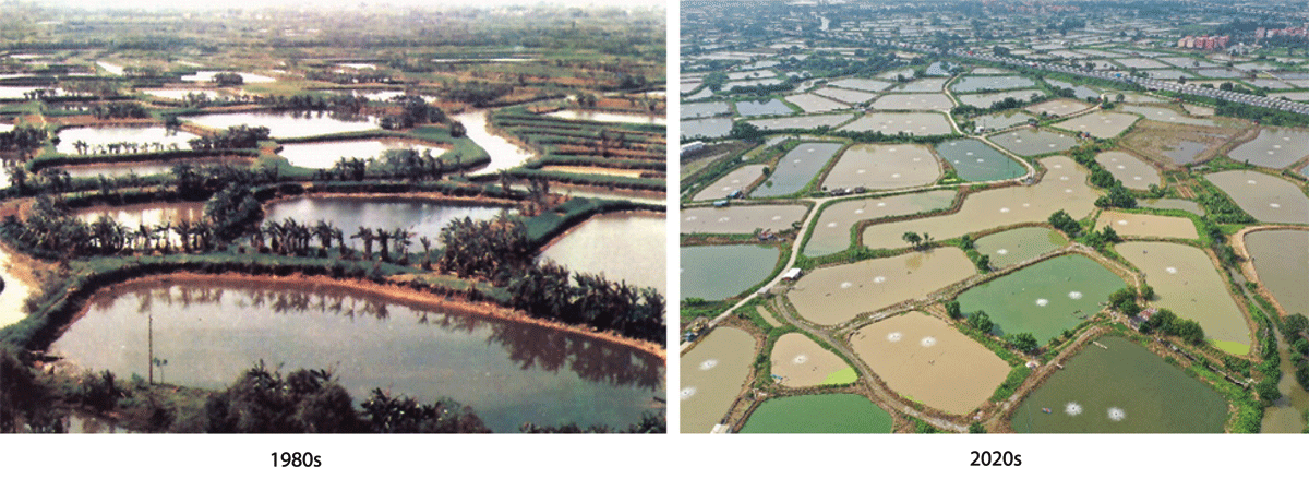
Figure 4
Comparison of the dike-pond system in the Pearl River Delta between the 1980s and 2020s. Left: Photo obtained from the Southern Silk Capital Museum in Shunde. Right: Photo taken by the first author.
(In the 1980s, the ponds were managed under low intensity and integrated with crops on the dikes. Since the start of the 2020s, the dike-pond system has been intensively managed, and many dikes have been abandoned).
Another noteworthy aspect pertains to the loss of multifunctionality within the system, corresponding to the emergence of monoculture practices. The intensified focus on fish farming has rendered previously diverse integrated farming practices (which included vegetation and livestock) economically unviable for farmers, leading to the establishment of a monocultural fish farming system. This transition is marked by amplified inputs and outputs. The shift involved the replacement of carp with higher-value fish species, substitution of grass feed with artificial alternatives, and advances in fish farming techniques. Consequently, breeding density surged drastically, from 7,500 fish/ha to 600,000 fish/ha. While heightened inputs yield increased fish production, it also leads to the generation of more waste, contributing to environmental concerns such as water and soil pollution.
Linkage between institutional arrangements and landscape simplification
Linkages between institutional arrangements and landscape simplification were reflected in multiple aspects, and interlinkages between different institutions were also found (cf. Figure 5). These findings imply that landscape simplification is the direct or indirect outcome of a combination of institutional arrangements. In return, landscape changes also exert feedback on specific institutions.
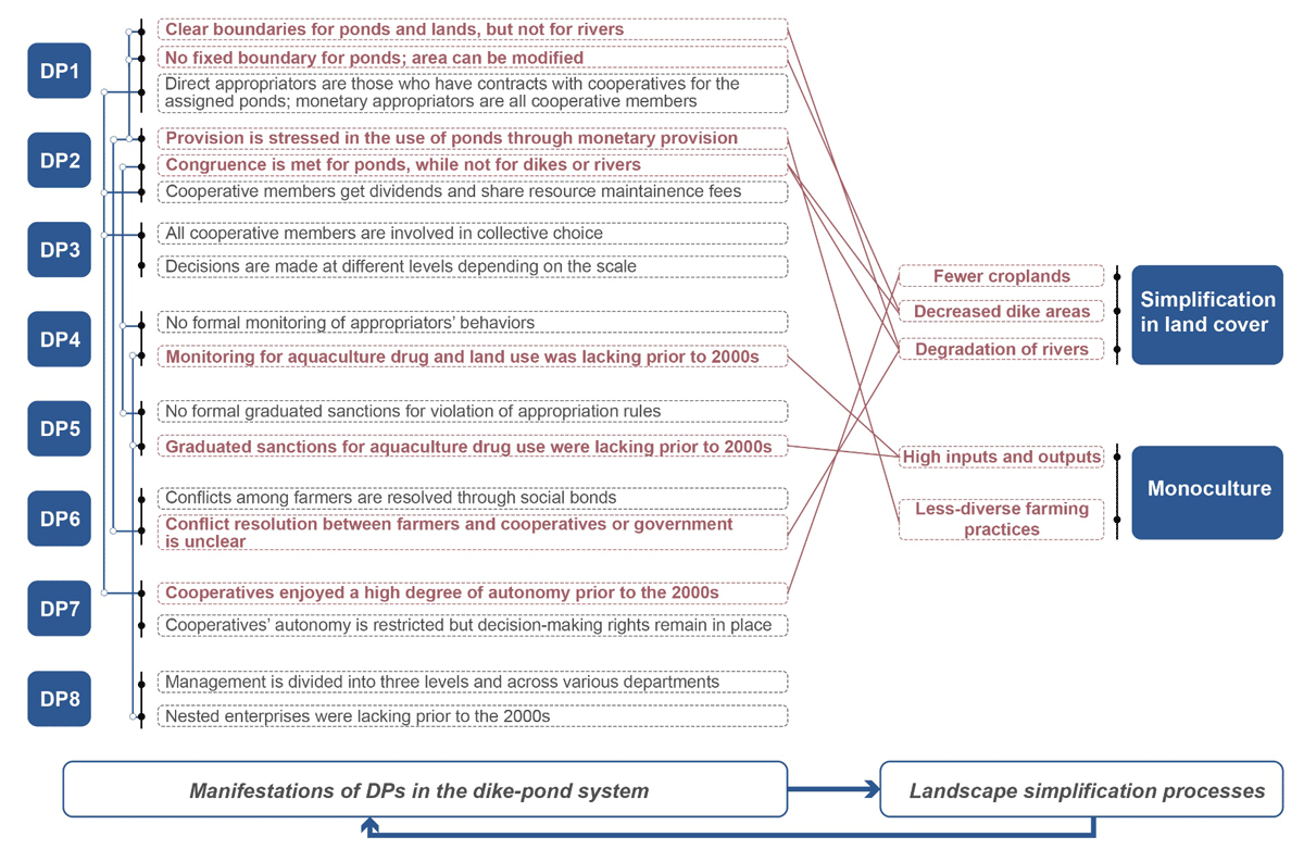
Figure 5
Linkages between institutional arrangements and landscape simplification of the dike-pond system, and interlinkages among institutional arrangements.
In regard to DP1, the lack of boundaries for rivers and roads in the dike-pond system, particularly for rivers, stands as the primary catalyst for the degradation of the natural infrastructure. Fish farming depends heavily on water sourced from the rivers, yet no explicit physical boundaries are established for managing the rivers. Furthermore, the absence of defined boundaries for the ponds indicates a lack of control over the dike areas. As a result, farmers have significantly expanded the water bodies, causing substantial declines in the croplands, sugar cane plantations, and mulberry trees that originally occupied the dikes. The absence of physical boundary rules also relates with a lack of rules in DP2, as the shared resources are not considered.
Regarding DP2, the emphasis on the monetary aspect of provision is evidently related to the simplification of land cover and the transition to monoculture in the dike-pond system. First, the focus primarily revolves around monetary provision and neglects other aspects of provision and appropriation, which is further compounded by the absence of formal rules for the monitoring of (DP4) and graduated sanctions (DP5) on appropriation behaviors, such as water-quality and vegetation maintenance. The absence of standardized implementation protocols within these institutions is conspicuous. For instance, verbal warnings may lack efficacy in addressing violations related to resource use, contributing significantly to the inadequate management of the dikes. Further, the heightened emphasis on economic relationships weakens farmers’ inclination toward burden-sharing in resource management, fostering intractable conflicts between farmers and cooperatives (DP6). This predicament has adverse implications for river maintenance, significantly contributing to the degradation of river systems within the landscape.
Institutions governing collective choice (DP3) are intricately intertwined with user boundaries (DP1) and provision and appropriation rules (DP2). The involvement of all cooperative members entitled to dividends from collective income as decision-making participants aligns with the user boundary regulations in that all the members reserve the right to benefit from the dike-pond system. This convergence has led to collective decisions prioritizing more lucrative land uses under the context of commercialization, consequently culminating in the decline of diversified land uses. These evolutions took place with governmental consent (DP7) before the 2000s.
Another pertinent link arises concerning nested enterprises (DP8). During the process of commercialization, nested enterprises experienced a lag in development between the 1980s and 1990s, which is notably evident in the inadequate monitoring and graduated sanctions pertaining to aquaculture drug use (DP4, DP5). Consequently, this gap led to a reliance on intensive management practices involving high inputs and outputs, thereby posing a threat to the functional integrity of the system.
Discussion
Design Principles (DPs) as a framework for diagnosing the governance of landscape simplification
A substantial volume of literature has supported the validity of Ostrom’s Design Principles (DPs) in the analysis of commons (e.g., Brossette et al., 2022; Chowdhury & Behera, 2022; Cox et al., 2010; Gautam & Shivakoti, 2005). However, these predominantly focus on single-resource systems, leaving a gap in understanding the applicability of DPs in holistic, multifunctional systems. In this study, we broaden the scope of commons research by exploring a landscape system that encompasses diverse biophysical dimensions and human factors. The concept of landscape commons assumes significance in unraveling the values, conflicts, and the pivotal role of local institutions involved in conserving and reshaping the functions and spatial characteristics of landscapes (Gerber & Hess, 2017; Menatti, 2017). Our study delves into the dike-pond system of the Pearl River Delta within the context of agricultural commercialization, presenting an exemplar showcasing the application of DPs in a multifunctional landscape system. This case study offers insights into how these principles can be applied within the intricate dynamics of a multifaceted landscape setting.
The case study from the Pearl River Delta underscores the critical importance of considering multiple biophysical elements and functions in landscape commons management. The reform and opening up has brought about agricultural commercialization in China. Consequently, the market played a leading role in agricultural land use, encouraging farmers to focus on high-value commodities of higher monetary value and to rely on resources that have more comparative advantages, notably emphasizing fish farming in the dike-pond system (Chen et al., 2022; Lai et al., 2020; Wong et al., 2004). Within the dike-pond system, elements such as ponds, dikes, rivers, and associated facilities traditionally played pivotal roles in facilitating diverse functions in an integrated agricultural system. However, the impact of commercialization has seen local communities prioritize fish farming and concentrate on pond management in collective decision-making, inadvertently neglecting elements like rivers, which are also crucial to successful fish farming. This prioritization has led to landscape simplification, consequently impacting the efficacy of fish farming practices.
The Design Principles framework provides a systematic elucidation of the interconnections between institutions and landscape simplification. Primarily, the stress on elements offering comparative monetary advantage is steered by the setting of physical boundaries (DP1), the prioritization of monetary provision for the pond area (DP2), and collective choice (DP3), culminating in homogenous landscapes with higher economical value. According to Brossette (2022), provision rules are important for maintaining multiple values of resources. In the dike-pond system, the absence of provisions for aspects such as rivers and dikes is an important reason for landscape simplification, as it erodes the cooperative members’ commitment and sense of responsibility for the entire system. Furthermore, institutional factors, such as a deficiency in maintaining multiple functions, notably reflected by the inadequate monitoring and graduated sanctions (DP4, DP5) originating at the governmental level, also played a role in the degradation of different landscape values and the loss of diverse landscapes. Finally, poor management of the landscape commons also stems from the imbalance between external forces and autonomy at the individual level (DP6, DP7). For example, the lack of equilibrium between the farmers’ high degree of autonomy in management and government intervention in maintaining spatial elements and functions exacerbates the landscape management challenges.
Strengthening the governance of landscape simplification in light of Ostrom’s Design Principles (DPs)
Our study unequivocally demonstrates the utility of Ostrom’s Design Principles (DPs) as an analytical framework for diagnosing landscape commons management practices, pinpointing specific elements which are pivotal in fortifying the governance of landscape simplification. Through the identification of institutional gaps, we underscore crucial aspects that warrant emphasis to enhance the management of landscape simplification processes. Although there is a high degree of variance in governance contexts among different social-ecological systems, this research significantly expands the application of the DPs within landscape commons confronted with landscape simplification, thereby fostering critical reflections on local institutional frameworks.
Primarily, a critical facet is the incorporation of multiple spatial elements into the establishment of physical boundaries and the provision and appropriation rules of landscape commons, which is directly linked to both DP1 and DP2 and is essential for maintaining natural and ecological resources. Physical boundaries are sometimes fuzzy, as landscapes are coherent geographical areas in which different actors, areas, and other processes are linked through natural and/or social processes (Graaf et al., 2017). For instance, in the dike-pond system, it is hard to identify the boundaries of rivers due to their mobility. However, the establishment of clear physical boundaries for maintenance purposes should be considered in order to prevent the tragedy of the commons as a result of inadequate management. In instances where direct community responsibility might be challenging, alternative strategies for provision could be explored. For instance, distributing expenses based on the resource scale and engaging an external agency for maintenance could be viable solutions. Moreover, provision should encompass considerations beyond mere monetary aspects, delving into resource conditions, social and environmental functions, and the intricate interplay between diverse variables (Brossette et al., 2022; Morrow & Hull 1996). This implies that the approach to provision may vary, contingent upon the specific functions of each element. In the context of the dike-pond system, while monetary provision is prioritized, equitable burden-sharing strategies could potentially sustain elements that have lower economic value yet which are crucial for biodiversity, water, and soil quality maintenance, such as dike upkeep.
Second, despite the existence of social norms, formal rules should be set regarding appropriation behaviors and resource conditions in the high-intensity management context. Previous studies have highlighted the potential of social attributes such as trust, transparency, and legitimacy to complement formal institutions and strengthen grassroots management (Cox et al., 2010; Dell’Angelo et al., 2016; Quynh et al., 2020; Sarker & Itoh 2001). However, our study illustrates that relying solely on social relations may not always prove effective amidst intensive management and evolving social division of labor. To address this challenge, a possible approach could involve the training of specialized monitors equipped with the necessary knowledge and skills for daily management monitoring.
Lastly, external governance emerges as a pivotal factor in steering sustainable management of landscape commons by offering critical support, including information dissemination, strategy formulation, and fostering of an enabling environment, thereby harmonizing local autonomy with top-down guidance (Bieling &, 2017; Morrow & Hull 1996). Given the multi-functionality and complexity of landscape systems, reliance solely on local institutions might prove inadequate, necessitating the integration of external governance structures. Tailoring policy tools to encompass the myriad functions and ecosystem services within these systems becomes paramount, thereby fostering favorable outcomes amidst commercialization and fortifying community-based governance in landscape commons management. For example, in the context of agricultural commercialization, integrating market-driven approaches—such as nurturing cultural and ecological tourism—offers a means to alleviate the pressures arising from intensive fish farming practices. This integration not only eases the strain placed on, but also amplifies the societal benefits derived from national agricultural heritage systems. Additionally, subsidy policies should focus more on incentivizing the cooperatives overseeing dike-pond systems to deliver a range of social and ecological services, such as the PES mechanism. For instance, providing subsidies to farmers for cultivating semi-natural plantations on dikes specifically aimed at biodiversity preservation emerges as a highly effective strategy within this framework.
Conclusion
In this study, we applied Ostrom’s Design Principles (DPs) to analyze the challenges confronting a specific type of landscape commons – pond landscapes – within a context of commercialization, focusing on the dike-pond system in the Pearl River Delta, China. Our research explained landscape simplification from an institutional view, extending the applicability of the DPs to encompass holistic, multifunctional systems and providing a rich case study in the context of China’s rapid commercialization. Our findings reveal that the unbalanced emphasis on ponds and fish production in collective-choice arrangements served as the primary driver behind the simplification of land cover and loss of functions in the dike-pond system. To enhance sustainable management capabilities within local institutions, we propose the following aspects: consider multiple spatial elements when setting physical boundaries and provision and appropriation rules; establish rules for formal monitoring and graduated sanctions suited to the demands of high-intensity management scenarios; and integrate external governance mechanisms to address the deficiencies observed within community-based institutions.
This study offers crucial insights into the role of institutions in landscape simplification, particularly pond landscapes. While the focus is locally specialized, we highlight the relevance of considering the biophysical characteristics and multi-functionality of the system, offering insights that may support other landscape commons studies in the context of rapid commercialization. Future research endeavors should strive to integrate local institutions into broader decision-making frameworks. For instance, exploring the interactions between local institutions, values, and knowledge would enrich our understanding of how institutions govern landscape commons. Such deeper explorations could unravel the intricate mechanisms underlying the functioning of institutions in managing diverse landscape systems.
Additional File
The additional file for this article can be found as follows:
Acknowledgements
We are especially indebted to Dr. Claudia Heindorf for the valuable suggestions on the study methodology and PhD candidate Shuang Liu for help with the diagram of the study area. Their prompt assistance was invaluable in improving the study.
Funding Information
This research is funded by the China Scholarship Council for one year of study at the University of Göttingen.
Competing Interests
The authors have no competing interests to declare.