
1. Introduction
Non-communicable diseases (NCDs) are a global health challenge and are responsible for more than 70% of deaths worldwide (WHO 2017). Research on the social determinants of health (SDH) establishes that the built environment influences health outcomes (Friel et al. 2011; Northridge et al. 2003). Urban planning, which shapes the built environment, can therefore contribute to improved urban health. Active transport and urban forestry are two examples of built-environment interventions with evidence-based benefits for human health, including encouraging physical activity and reducing urban heat. The complex relationships between NCDs and urbanisation necessitate integrated solutions, yet disciplinary silos restrict coordination across governments to respond holistically to these multifaceted challenges (Nieuwenhuijsen 2016).
This study examines this global problem from a local perspective. Specifically, the City of Melbourne (CoM), Australia, is used as a case study of alignment across three key policy domains – health and wellbeing, active transport and urban forestry – to achieve common public health goals. Australian cities are some of the most car-dependent in the world (Saeidizand et al. 2022), which is a contributing factor to NCDs (Stevenson et al. 2016; Sugiyama et al. 2020). The policy analysis finds that the CoM adopts a holistic approach towards addressing the SDH in municipal planning. However, there are gaps in addressing indirect health risks that are ancillary to achieving overarching health and wellbeing goals. Further spatial analysis supports this finding by demonstrating that, while the cycling network and urban forest are comprehensive, they are often misaligned. This diminishes the potential for transport and urban forest strategies to achieve health-promoting co-benefits. These findings raise key considerations for cities looking to increase their active transport mode share: transport and urban forestry policies, and their associated cycling infrastructure and tree canopy outcomes, should be better aligned and integrated to achieve common public health goals.
This paper is arranged as follows: Sections 1.1 and 1.2 review research on the SDH, their links to active transport and urban forestry, and the role of urban planning policy alignment. Section 2 presents the methods adopted in this study, and the results of the policy and spatial analyses. The paper concludes with discussion of these findings, and key policy recommendations.
1.1 Social determinants of health
The SDH are the social and environmental conditions in which people are born, grow, live and age (Dahlgren & Whitehead 2021). There is growing evidence of the importance of the form and function of the built environment in tackling NCDs such as cardiovascular disease, respiratory disease and cancer (Northridge et al. 2003; Vlahov et al. 2007). Specific aspects that are closely linked to health outcomes include transport mode choice (Giles-Corti et al. 2016) and access to green spaces (Rigolon et al. 2021; van den Bosch & Ode Sang 2017).
Transport systems are a determinant of health for several reasons. Efficient transport connections facilitate access to essential services and influence their quality of life. Walking and cycling as modes of transport are forms of incidental physical activity with health benefits for individuals and populations (Lee et al. 2012; Kelly et al. 2014; Mizdrak et al. 2019). Globally, around one in three women and one in four men do not meet the recommended levels of physical activity (WHO 2022). In response, many countries are using active transport (walking and cycling) to increase physical activity within urban populations (Heath et al. 2012). This paper focuses on cycling as it requires greater physical exertion, can cover trips of a greater distance, and improves physical and mental health (Oja et al. 2011).
1.2 Active transport and urban forestry planning
Giles-Corti et al. (2016) identify infrastructure design and desirability as two of eight integrated land use and transport planning interventions that are linked to improved health and wellbeing. This is supported by research on functional design factors, such as safety features, which impact individuals’ decisions to cycle for transport (Ek et al. 2021; Fraser & Lock 2010; Pearson et al. 2022). Other built-environment factors that encourage cycling include proximity to services and amenities, and aesthetic features such as greenery (Wendel-Vos et al. 2004; Zlot & Schmid 2005).
The rise in global temperatures over the next century poses a significant threat to active transport goals since extreme heat is a deterrent to outdoor physical activity (Ferguson et al. 2023). This is exacerbated in urbanised areas because of the urban heat island effect, whereby urban areas are hotter than surrounding rural areas owing to increased absorption and retention of heat (Li et al. 2019). Furthermore, higher temperatures are linked to increased mortality and morbidity (IPCC 2023). Transport policy alone is therefore insufficient to address physical inactivity due to its interaction with other NCD risk factors such as urban heat.
In the context of rising global temperatures and exposure to heat-related illnesses, urban forestry is one solution to mitigate heat vulnerability (Konijnendijk & Randrup 2004; Sadeghi et al. 2022). Urban forestry and tree canopy have been linked to reduction in surface temperatures (Lungman et al. 2023). While air temperature (the thermal comfort factor perceived by humans) and surface temperature are often not well correlated (Du et al. 2024), with surface temperatures more variable than air temperatures over the course of a day, the relationship is city-dependent (Gartland 2008). Recent research has found that there is a stronger correlation in some Australian cities, particularly in summer, between air and surface temperature during both day and night; urban development patterns as well as geographic characteristics may have influence (Naserikia et al. 2024). Beyond heat reduction, street trees and urban forests also have other co-benefits for human health (Ulmer et al. 2016; Wolf et al. 2020).
Since more than 68% of the world’s population will live in urban areas by 2050 (United Nations 2019), there is a need for urban planning to address health determinants within cities. Urban planning has the potential to contribute to public health benefits, through policies to increase both active transport and tree canopy (urban forests). Table 1 summarises the linkages between the two policy domains and key public health goals.
Table 1
Influence of active transport and urban forest strategies on achieving public health goals
| PUBLIC HEALTH GOAL | ACTIVE TRANSPORT | TREE CANOPY (URBAN FOREST) |
|---|---|---|
| Physical activity | Direct influence: promotes physical activity (Kelly et al.2014; Mizdrak et al.2019) | Indirect influence: aesthetic features that make the built environment more pleasant for walking and cycling (Wendel-Vos et al.2004; Zlot & Schmid 2005) |
| Urban heat mitigation | Direct influence: reduces anthropogenic heat from vehicles (Singh et al.2022). Indirect influence: a modal shift away from motor vehicles reduces greenhouse gas emissions, slowing warming in the long term (Rojas-Rueda et al.2011) | Direct influence: lower ambient heat through shading and evapotranspiration (Lungman et al.2023) |
Policy alignment is important because urban health challenges are complex, interdependent and cut across disciplines (Frank et al. 2020). At times, interventions to address one issue may compromise the outcomes of another. Disciplinary silos often pose a barrier to integrated urban infrastructure implementation; thus, interdisciplinary coordination is critical to addressing the interconnected challenges that affect urban health (Amri 2022).
2. Methods
The aim of this study is to examine the alignment of policy to achieve common public health goals. The study asks: how are the City of Melbourne’s Transport Strategy and Urban Forest Strategy aligned to achieve common public health goals? The CoM is used as a case study to investigate broader global trends in the alignment of active transport and urban health policy. It is one of 31 councils within Greater Melbourne, Australia, and covers 37 km2 (City of Melbourne 2023). Greater Melbourne, encompassing the entire metropolitan area, is the second most populous capital city in Australia and had the highest growth in 2022–23 (Australian Bureau of Statistics 2022–23).
The CoM has demonstrated the political will to address urban health, increase active transport mode share and increase urban tree planting through three separate strategies: the Health and Wellbeing Plan 2021–2025 (HW Plan), the Transport Strategy 2030 and the Urban Forest Strategy 2012–2023. Two separate documents, which together constitute the HW Plan, are analysed – the CoM’s overarching strategic document, the Council Plan 2021–2025 (Council Plan, which incorporates the Health and Wellbeing Plan) and the Health and Wellbeing Action Plan 2021–2025 (Action Plan). The Transport Strategy recognises the need to increase active transport mode share and the Urban Forest Strategy states a target canopy cover of 40% by 2040. However, it is not clear if the goals set out in the HW Plan are aligned with or facilitated by either of these two strategies. The case study of the CoM can therefore elucidate learnings for other cities looking to more effectively implement active transport and urban forest strategies. The design of this study combines qualitative policy analysis with spatial analysis to investigate the intersection of public health goals with active transport and urban forest planning. As such, data collection and analysis bring together qualitative and spatial analysis to triangulate results and provide in-depth insights.
The policy analysis focuses on the three policy domains of the HW Plan, the Transport Strategy and the Urban Forest Strategy. Policies are analysed using directed content analysis, to assess the extent to which health risks (SDH; risks of physical inactivity; risks of exposure to urban heat) and associated solutions are identified and addressed. Directed content analysis involves a detailed search and reading of each document to determine the inclusion and comprehensiveness of coverage of predetermined terms and themes (Hsieh & Shannon 2005). The selection of these predetermined terms and themes is informed by the reviewed research, which points to the key considerations for effective policy for each of the domains under consideration (MacCallum et al. 2019). The results of the analysis are represented using a numeric scoring scale, which differentiates between implicit and explicit consideration of public health goals, consistent with other studies (Bush 2020), with 0 indicating no coverage and higher numbers indicating implicit and ultimately explicit inclusion.
Spatial analysis is conducted with geographic information system (GIS) software to examine the alignment of active transport and urban forestry infrastructure in the CoM, using publicly available bicycle lane data and tree canopy data (see the supplemental data online for detail on the analytical approach and methods). The percentage surface area of each bicycle lane that is covered by tree canopy was calculated to determine the extent to which each segment of bicycle lane is aligned with canopy cover. This analysis also generates insights on the areas of the cycling network with the highest and lowest canopy cover. The spatial analysis triangulates findings from the policy document analysis, and provides a geographically grounded evidence base for examining the alignment of active transport and urban forestry policies.
3. Results
This section presents the results of policy analysis followed by the spatial analysis. The findings of the analysis of the policy documents (health, transport and urban forest), are summarised in Table 2 and then discussed across the themes of SDH, physical inactivity and urban heat.
Table 2
Policy analysis results
| PUBLIC HEALTH GOAL | HEALTH AND WELLBEING PLAN1 | TRANSPORT STRATEGY | URBAN FOREST STRATEGY |
|---|---|---|---|
| Social determinants of health | 3 | 1 | 1 |
| Air pollution risk | 3 | 3 | 1 |
| Air pollution measures | 0 | 1 | 1 |
| Physical inactivity risk | 3 | 3 | 3 |
| Physical inactivity measures | 2 | 3 | 1 |
| Urban heat risk | 3 | 1 | 3 |
| Urban heat measures | 3 | 2 | 3 |
[i] Note: 1The Health and Wellbeing Plan is published in two documents: the Council Plan 2021–2025 and the Health and Wellbeing Action Plan 2021–2025.
3.1 Policy analysis
3.1.1 Social determinants of health
All policy documents considered the SDH; however, this was most prominent in the HW Plan (published as the Council Plan and Action Plan) (Table 2). The Council Plan utilises a planning lens that centres around health inequity and place-based planning, with reference to the United Nations Sustainable Development Goals. The CoM’s health and wellbeing priorities are integrated into the strategic objectives and vision of the Council Plan, which uses a heart-shaped icon to visually elevate priorities and major initiatives that align with health and wellbeing focus areas. Overall, the Council Plan is effective in addressing a broad range of SDHs, including physical activity, transportation and adaptation to climate change. This flows through to the Action Plan, which contains six focus areas that are aligned with the strategic objectives of the Council Plan.
While the Transport Strategy and Urban Forest Strategy do not explicitly reference health and wellbeing, the SDH framework is implicit within both these documents, which respectively acknowledge the contribution of transport planning and urban forestry to health and wellbeing. The Transport Strategy references a state policy objective to achieve safety, health and wellbeing and broadly associates public and active transport with healthier cities. The Urban Forest Strategy acknowledges the contribution of the urban forest to health and wellbeing in its ‘Vision and Introduction’, which specifies a range of social, environmental and economic benefits of the urban forest. The Urban Forest Strategy frames the health of the urban forest and community as interrelated concepts and encourages the inclusion of wellbeing indicators to monitor the success of the urban forest.
3.1.2 Physical inactivity
Physical inactivity is the health risk most consistently mentioned across all policy documents. In its demographic profile, the Council Plan specifies physical activity as a health and wellbeing indicator and determinant of health. Similarly, the Action Plan raises physical inactivity as a key issue. Notably, it acknowledges that healthy lifestyles are determined by ‘functions of people in their employment, living environment, recreation and diet’ (City of Melbourne 2021: 32) and places responsibility on the city to provide opportunities for fostering wellbeing. The Transport Strategy explicitly mentions the association between motor vehicle use and negative health outcomes such as ‘obesity, heart disease, diabetes, depression, stress and anxiety’ (City of Melbourne 2020: 32). The Urban Forest Strategy does not seek to directly promote physical activity. However, it acknowledges outdoor physical activity as a benefit of the urban forest.
To address physical inactivity, the Council Plan contains initiatives that encourage active travel, along with non-specific goals to increase physical activity and active transport levels in the municipality. It also cross-references the Transport Strategy as a key document that supports health and wellbeing. The Action Plan contains initiatives focused on cycling, public and active transport, and promoting gender equity in recreation. The Transport Strategy seeks to increase physical activity solely through measures to increase bicycling in the CoM. This includes general support for e-bike usage, delivery of bicycle infrastructure and community programmes to encourage bicycling. The Urban Forest Strategy contains one general statement of support for the encouragement of outdoor activity and exercise, through public space design. Overall, all documents except the Urban Forest Strategy associate physical activity with walking and cycling; however, only the Transport Strategy contains specific active transport targets – namely, the number and quality of bicycle lanes.
3.1.3 Urban heat
The risk of urban heat is mentioned and linked to health and wellbeing in all documents except the Transport Strategy, which only references climate change at a high level. The Council Plan mentions urban heat risk within discussions of extreme weather events and the public health impacts of climate change, and explicitly names the urban forest as a key solution. The Action Plan goes into greater detail about specific health and wellbeing impacts, including housing stress and food security. Overall, the HW Plan takes a holistic approach to understanding and responding to the risk of urban heat within the community. Similarly, the Urban Forest Strategy is explicit in stating that one of its key aims is to reduce the urban heat island effect and reduce heat-related illnesses, particularly for vulnerable populations.
The Council Plan contains actions that contribute to heat mitigation, such as the delivery of green spaces and tree canopy, emissions reduction and preparedness for extreme weather. Several actions address the public health impacts of climate change but lack measurable targets. The Action Plan is more specific in addressing urban heat, through referencing ongoing council initiatives. Collectively, the documents forming the HW Plan contain explicit targets around emissions, tree canopy cover and tree planting in the municipality. The Transport Strategy does not contain any clear actions that directly address urban heat; however, it has actions to reduce emissions generally, with one instance that references greenhouse gas emissions. The Urban Forest Strategy supports tree canopy cover as a mitigator of urban heat and improved thermal comfort and specifies a target of 40% canopy cover by 2040, significantly greater than the 30% target identified in state-level planning (Infrastructure Victoria 2021: 211). The Urban Forest Strategy also outlines metrics to assess the urban forest’s contribution to reducing thermal discomfort and urban heat.
3.2 Spatial analysis
The spatial analysis assessed the canopy coverage of existing and planned bicycle lanes within the CoM. A multicolour scheme distinguishes the different proportions of canopy coverage:
0% tree canopy coverage
between 1% and 40% tree canopy coverage, and
more than 40% tree canopy coverage.
3.2.1 Existing bicycle lanes
Most existing bicycle lanes have less than 40% canopy coverage, with areas of highest canopy coverage located within existing parks and green spaces such as Yarra Park (7) and Fawkner Park (9) (Figure 1). Established key cycling corridors along Royal Parade (1), Swanston Street (6) and St Kilda Road (8) also have a relatively high canopy coverage. Areas that are most lacking in canopy include newer cycling routes in the south. The analysis highlights gaps in the current cycling network, although it is anticipated that many of these infrastructure gaps will be filled upon delivery of the planned cycling lanes.
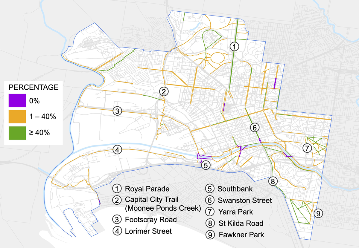
Figure 1
Tree canopy coverage (percentage) of existing bicycle lanes.
3.2.2 Future bicycle lanes
Bicycle lanes proposed for construction have lower overall canopy coverage than existing lanes, particularly in the Fishermans Bend (3) and Docklands (2), which are both urban renewal areas in post-industrial precincts (Figure 2). Along the Royal Parade (1) and St Kilda Road (4) corridors, additional bicycle lanes are proposed adjacent to existing lanes. However, in current conditions, the proposed alignments have lower canopy coverage than existing bicycle lanes along the same corridor. Therefore, while infrastructure gaps may be addressed through the delivery of future bicycle lanes, this does not guarantee that the future cycling network is resilient to heat stress. The planning and delivery of future bicycle lanes should be cognisant of heat vulnerability and measures taken to reduce cyclists’ exposure to heat. Indeed, prioritising these areas for tree planting in the short term would assist this.
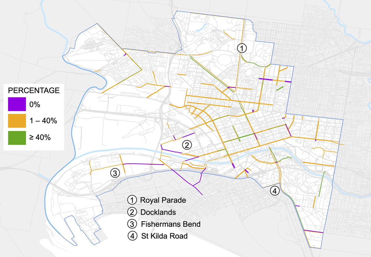
Figure 2
Tree canopy coverage (percentage) of proposed bicycle lanes.
3.2.3 Ultimate cycling network
Given current canopy coverage, most of the ultimate cycling network (i.e. combined current and future bicycle lanes) does not align with the 40% canopy cover target set out in the Urban Forest Strategy, or the 30% target set out by state guidelines (Figure 3). It is acknowledged that a range of constraints limit the extent of canopy tree provision along roads and bicycle lanes, such as overhead power lines, conflicts with pedestrian paths and underground utilities. However, given the CoM’s aspirations to increase cycling mode share and enhance the urban forest, this analysis identifies locations that would benefit from better alignment of cycling infrastructure and tree canopy.
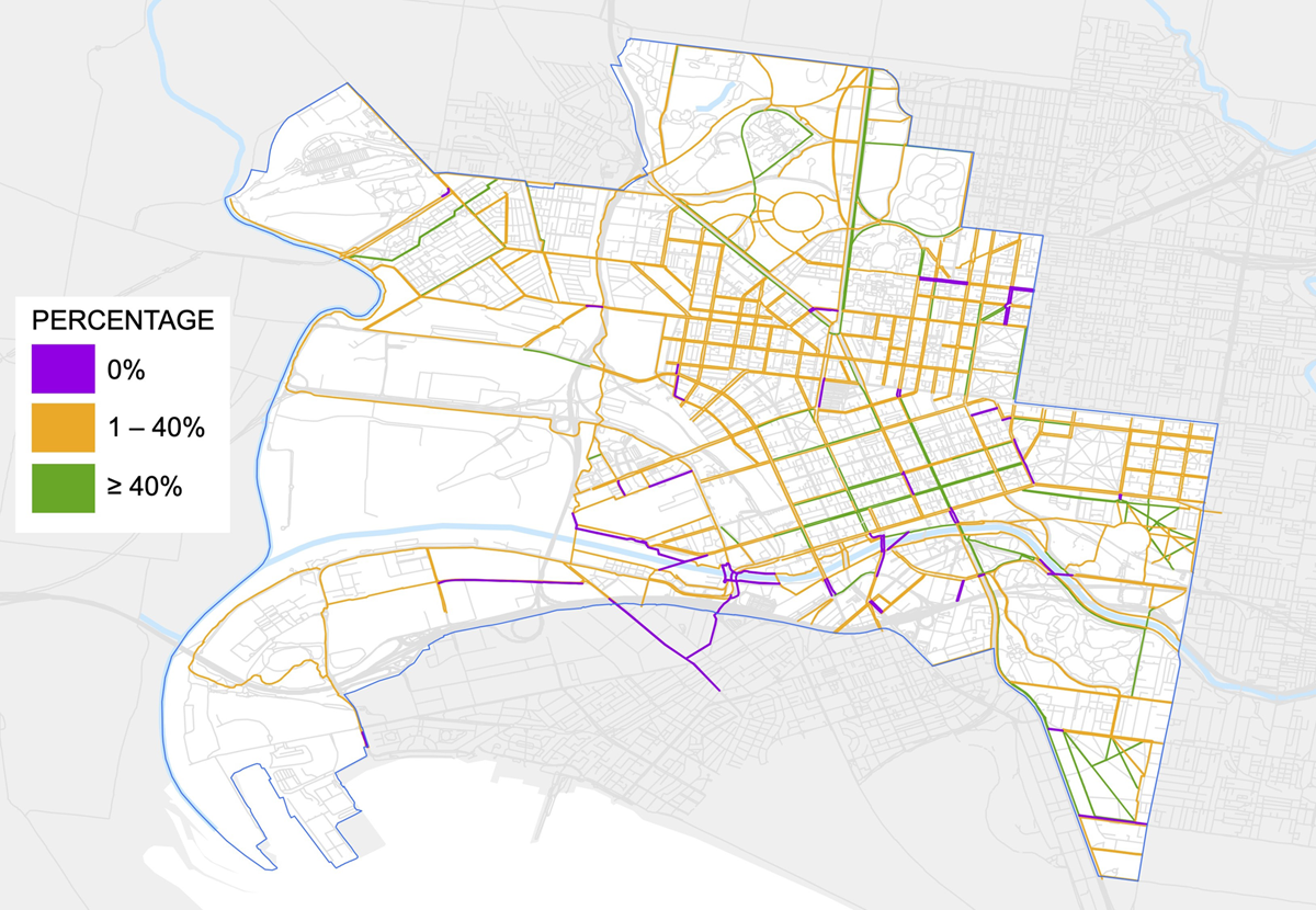
Figure 3
Tree canopy coverage (percentage) of ultimate bicycle network (current and future bicycle lanes).
4. Discussion
The objectives of this study are to identify how the CoM’s HW Plan, Transport Strategy and Urban Forest Strategy are aligned, and how they together address public health risks. The analysis triangulated findings from policy and spatial data to demonstrate that CoM embeds the SDH framework into its strategic plans and addresses health risks in isolation. However, the three policy domains – health and wellbeing, active transport and urban forestry – can be better aligned to tackle the interconnected challenges of physical inactivity and urban heat. Many of these findings are applicable to both urbanised and rapidly urbanising cities looking to strengthen policy and infrastructure outcomes in these three domains.
4.1 Policy alignment and SDH
The HW Plan aligns with the SDH framework and holistically addresses a range of health and wellbeing risks, including physical inactivity and urban heat. A key strength of the CoM’s health and wellbeing planning is the intentional and explicit integration of all health and wellbeing priorities into the Council Plan objectives, instead of being restricted to one discrete objective. The HW Plan cross-references other plans and policies, including the Transport Strategy and Urban Forest Strategy, thus emphasising the contribution of active transport and urban forestry to municipal health and wellbeing.
The Transport Strategy and Urban Forest Strategy consider the SDH framework, but to a lesser extent than the HW Plan. Given the discipline-specific nature of the Transport and Urban Forest strategies, it is unsurprising that the extent of cross-referencing to other policies is narrower than the Council Plan. The Transport Strategy makes efforts to encourage integrated transport planning, which seen most clearly through actions that encourage public and active transport and improve safety on streets. However, actions to align urban forestry with active transport are lacking. Likewise, the focus of the Urban Forest Strategy is on the contribution of the urban forest to health and wellbeing, primarily through shading and cooling. While it highlights streets as the most important public spaces for increasing canopy cover, it does not mention opportunities to align urban forestry with active transport initiatives.
The lack of intentionality in aligning active transport and urban forestry policy is reflected in the spatial analysis, which indicates significant gaps in tree canopy cover within the cycling network. While it is not feasible for all bicycle lanes to be planted with trees owing to conflicts with other road uses and infrastructure, the gaps in tree canopy within the cycling network nonetheless raise concerns about the vulnerability of cyclists and other active transport users to a warming climate. Transport planners and urban foresters should also consider whether key cycling routes can be adjusted to align with streets that already have high canopy coverage or are conducive to canopy tree planting. Trade-offs between active transport and tree canopy outcomes may arise owing to space constraints or resource competition, which is an area for future research.
4.2 Urban heat a barrier to physical activity
Physical activity is strongly tied to improved health and wellbeing within all the documents analysed. This is consistent with the evidence that NCDs are rising among high-income countries, thus action is needed to address physical inactivity as a priority risk factor for chronic disease. The CoM has prioritised the promotion of physical activity, having identified that over half the adult population in the municipality do not meet the recommended levels of physical activity (City of Melbourne 2012: 9). Physical activity is most clearly addressed within the Transport Strategy, which has direct influence on transport modes and active transport. However, while the Transport Strategy has robust measures to promote active transport, it does not consider or address the threat that urban heat poses on active transport goals. This omission is reflected in the spatial analysis, which reveals that many cycling routes in the CoM are insufficiently shaded to meet both state and CoM canopy targets. While bicycle lane gaps are expected to be filled in over time, future cycling infrastructure is not matched with strategic tree planting along key cycling routes, leaving cyclists exposed to urban heat.
4.3 Limitations and future research
The research is limited owing to reliance on publicly available data and therefore did not capture current or ongoing internal discussions or initiatives that might contribute to or detract from policy alignment with urban health goals. Nonetheless, the study provides valuable insight into the vulnerability of cyclists to urban heat. The study was limited to current tree canopy data. Detailed spatial data on the future tree canopy were not publicly available. Spatial data on anticipated tree planting would complement the analysis of the future cycling network, to facilitate a deeper understanding on the future vulnerability of active transport users to urban heat. Future research on this or other cities could also extend the spatial analysis to include, for example, calculation of number of residents and businesses affected by different scenarios of active transport network coverage and tree canopy coverage. This could have policy relevance in terms of building the business case for expanding both active transport and tree planting programmes.
The combination of policy and spatial analysis generates robust insights. Future research could replicate this methodology to investigate different cities across a wider geographic scale, to assess the alignment of urban planning policy with public health goals and identify strengths and weaknesses of different jurisdictions. Future research could incorporate other metrics of SDH, for example by combining temperature metrics (including thermal imagery, or crowdsourced air temperature or thermal comfort records (Naserikia et al. 2024)) and areas of high foot traffic to investigate the vulnerability of pedestrians to urban heat.
5. Conclusion
This study examines the alignment of active transport and urban forest policies to achieve public health goals, using the CoM as a case study. Analysis of policy documents and spatial data point towards a strong commitment by the CoM to cultivate a robust cycling network and urban forest in the long term, reflecting a growing global recognition of these two urban interventions. Active transport is recognised as a priority for addressing physical inactivity and urban forestry is recognised as a means of tackling urban heat. However, while the CoM’s Transport Strategy and Urban Forest Strategy are strong in addressing the health risk that is central to each document, there is no clear mention of other health co-benefits that could be achieved. The two policies also lack linkages with each other, which is a missed opportunity to strengthen policy alignment and to address a wider range of public health risks.
The CoM has separate targets for bicycle lane provision and tree canopy cover, with ambitions to deliver 90 km of bicycle lanes by 2030 and 40% canopy cover by 2040. Spatial analysis reveals that this 40% target is not achieved across most of the existing cycling network, and even less so along proposed future bicycle lanes. The spatial analysis identifies gaps in the network where cyclists are most vulnerable to urban heat, and thus where active transport and urban forest infrastructure could better align to address key public health risks. This research is directly relevant to many other cities globally that are seeking to strengthen their achievement of public health goals, as well as associated environmental targets and objectives. Other cities could utilise similar spatial analyses to develop and evaluate transport and urban forest strategies. Further, consideration of locating the active transport network in areas of existing canopy cover (rather than relying on planting to create future canopy cover) could encourage increased active transport in the short term.
Beyond the Melbourne context, NCDs are a rising threat to urban health globally, compounded by emerging stresses such as a warming climate. Urban planning is playing an increasingly prominent role in addressing these complex and large-scale problems, through built environment interventions. Effective responses to multifaceted challenges require coordinated action across disciplines, both within governments and between private and public sectors. This study adds to knowledge at the intersection of urban planning and urban health by raising questions of policy alignment, both within policy documents and as they translate spatially to infrastructure outcomes. Building on momentum within the urban health literature, this study reinforces the importance of urban environments to public health and urges policymakers to adopt human and planetary health as a key driver for plan-making and evaluation.
Acknowledgements
The authors thank Hannah Lewi, Coordinator of the Bachelor of Design (Hons) programme, for support and guidance throughout the first author’s research.
Competing interests
The authors have no competing interests to declare.
Data accessibility
Publicly available spatial analysis data is referenced in the supplemental data online.
Supplemental data
Supplemental data for this article can be accessed at: https://doi.org/10.5334/bc.508.s1