

1. Introduction
Modern military operations are nowadays defined by their ability to maintain resilient communication links in contested and electronically saturated environments (Wang, Shi, Yang, & Feng, 2022). High Frequency (HF) radio remains a base stone of this resilience, especially in diverse geographical terrains like Romania, due to its unique capacity for long-range and Near Vertical Incidence Skywave (NVIS) propagation.
Traditional HF planning relies on established numerical engines like the Voice of America Coverage Analysis Program (VOACAP) – (Islam & Hossam-E-Haider, 2024), which provides robust median predictions based on historical solar cycles. However, these tools operate as static systems requiring manual input of ionospheric parameters, failing to reflect hour-by-hour fluctuations during solar disturbances.
Recently, the topics was marked by the emergence of web-based platforms and sophisticated software suites like the ITS HF Propagation tool as specified by Lane (2005) and by Wang, Ding & Wang (2018), which offer high-fidelity global modelling. However, these existing tools often operate as static systems, requiring manual input of ionospheric parameters. These approaches may not reflect the rapid, hour-by-hour fluctuations of the ionosphere during solar disturbances (Hervás, Bergadà & Pages, 2020; Coetzee & Du Plessis, 2020). Moreover, while high-end military systems integrate Automatic Link Establishment (ALE) to mitigate these issues, they often function somehow similar to black boxes, by providing the operator just limited tactical visualization and requiring constant over-the-air handshaking, thing that can increase the probability of detection (Bilal & Sun, 2017; Khodaverdizadeh, Haghbin & Razzazi, 2022).
Most of the current-used software also lacks a unified vision upon specific, localized terrain analysis, leaving a gap between electromagnetic propagation fundaments and the physical obstacles of a specific theatre of operations (Soo, Lim, Chee, Lim & Yap, 2025).
To bridge this gap, this paper presents HF Predictor Romania, a specialized software implementation designed to wrap, automate, and enhance the VOACAP engine into a dynamic, real-time tactical decision-support ecosystem. Rather than proposing a new electromagnetic propagation method, this work introduces an automated data-fusion architecture that feeds live ionospheric and solar updates directly into VOACAP, optimizing tactical planning for radio operators.
The originality of this work lies in its hybrid architecture. Unlike conventional propagation tools that rely only on historical data (Buckley & Furman, 2021) our application combines the VOACAP core with live ionospheric feeds from Global Ionospheric Radio Observatory (GIRO/ DIDBase) and with solar activity updates provided by the U.S. National Oceanic and Atmospheric Administration (NOAA, 2026). Our tool incorporates a real-time validation through Weak Signal Propagation Reporter (WSPR) spots, so that the application transforms from a calculator into a dynamic decision-support tool. An important aspect is also the one that the software addresses specific tactical issues – such as Low Probability of Intercept (LPI), through automated power optimization and terrain-aware analysis using Shuttle Radar Topography Mission (SRTM90) data (NASA Shuttle Radar Topography Mission [SRTM], 2013) – tailored specifically for the Romanian field of operations.
A remarkable point is that the application is engineered for high-stakes environments, maintaining full operational capability in offline scenarios. This integration of real-time data fusion, localized terrain modelling, and tactical automation represents an important advancement over the other planning methods, providing radio operators with actionable intelligence in seconds.
2. System Architecture and Technical Implementation
The development of HF Predictor Romania was based on the need to obtain a balance between computational precision and tactical agility. The architecture of the application is modular, based on Python and Tkinter framework to provide a high-contrast, dark-themed graphical user interface (GUI) optimized for low-light operational environments. The core logic focuses on streamlining the user workflow by masking the underlying complexity of the Fortran-based VOACAP core.
The operational logic of the application is illustrated in Figure no. 1 which indicates the data flow of the system. When a network connection is detected, real-time environmental data receive priority. Simultaneously a robust autonomous capability is maintained through its internal geophysical databases. In this way the transition from raw input to tactical recommendation is seamless and verifiable.
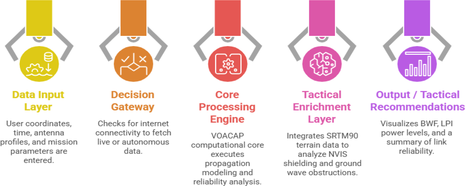
Figure no. 1:
System Operational Architecture: Integrated data fusion and decision logic flow for HF Predictor Romania
(Source: Authors, AI-generated)
The operational backbone of our application is given by its tactical configuration interface (Figure no. 2). As observed, the dashboard centralizes critical decision-making parameters – including noise floor levels for specific transmitting/receiving (TX/RX) environments and synchronization of real-time ionospheric data. As also observed on the interface, the system lively integrates readings of the critical frequency foF2 (of the F2 layer of the ionosphere) – in our example here from the GIRO-Sofia station (the nearest one), and solar indices (SSN, SFI) directly into the prediction workflow. In this manner we ensured that the propagation model is based on current atmospheric conditions and not on the static historical medians.
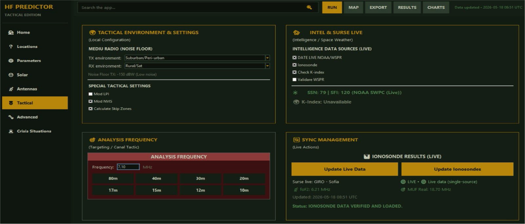
Figure no. 2:
The tactical configuration interface of HF Predictor Romania, illustrating the integration of live ionospheric data, solar indices, and tactical environment settings
(Source: Authors, original application GUI)
2.1. Core Computational Engine
VOACAP engine stays in the heart of our system; it is regarded even today as the gold standard for HF propagation modelling.
The system interacts with VOACAP by automatically generating the necessary *.WG8 input files based on user-selected or live-fetched variables, executing the core engine as an external background process, and parsing the text output matrices into visual data within seconds. Unlike standard VOACAP usage – which requires manual entry of smoothed sunspot numbers (SSN) – our engine dynamically injects live critical frequency (foF2) readings from the closest GIRO ionosonde stations (e.g., Sofia) and real-time solar indices from NOAA JSON APIs.
2.2. Dynamic Data Integration and Fall-Back Mechanisms
One of the most critical methodological innovations is represented by the system’s ability to transition between online and offline modes.
a) Real-time mode: When Internet connectivity is available, the application requests the GIRO/DIDBase to provide the latest foF2 and hmF2 (F2 layer height) values. It also integrates solar flux and sunspot numbers (SSN) directly from NOAA via JSON APIs.
b) Predictive/Offline mode: When the network is not detected to function, the system flips back on the ITU-R P.1239 (ITU, 2012) ionospheric maps and historical solar indices. This way the military planner has access to the best possible data, regardless of the electronic environment.
2.3. Terrain and NVIS Modelling
A localized accuracy within the Romanian area is provided based on our methodology to incorporate SRTM90 data. Furthermore, the application integrates the Open-Meteo Elevation API, so that it extracts high-resolution elevation points to reconstruct the physical path between the transmitter (TX) and receiver (RX). This spatial knowledge is vital for identifying any electromagnetic shielding caused by the Carpathian mountain ranges, and provides the complete data for the software to calculate how to overcome the skip zone challenges induced by the terrain discontinuities.
3. Tactical Analysis and Specialized Modules
Standard propagation software focuses on general link probability, but HF Predictor Romania application introduces three special-destined modules. They respond to rigorous demands of military and emergency environments. These modules transform the tool from a theoretical model to a dynamic decision-support system.
To validate the operational advantage of the HF Predictor Romania implementation over standard, static VOACAP planning, a comparative analysis was conducted.
3.1. Near Vertical Incidence Skywave and Terrain Awareness
In the rugged geography of the Romanian Carpathian Mountains, LOS communication is frequently obstructed by relief forms. The solution in these cases is using NVIS as an operational solution. This module automates the calculation of the critical frequency foF2 and the optimal take-off angles, so that the radio wave to be reflected at steep angles and to bypass mountain ridges.
The software makes use of the previously mentioned terrain profiles to visualize shadow zones where HF ground waves fail transmission due to terrain masking.
As illustrated in Figure no. 3, which shows a scenario of a HF link between Dărmăneşti and Sângeorz-Băi localities, the operator can superimpose the 176.3 km great-circle path onto the topographic map. This spatial instrument allows for an immediate determination of whether an NVIS or rather a standard skywave approach is better used for a successful link, effectively confirming the optimal propagation mode in the contested relief.
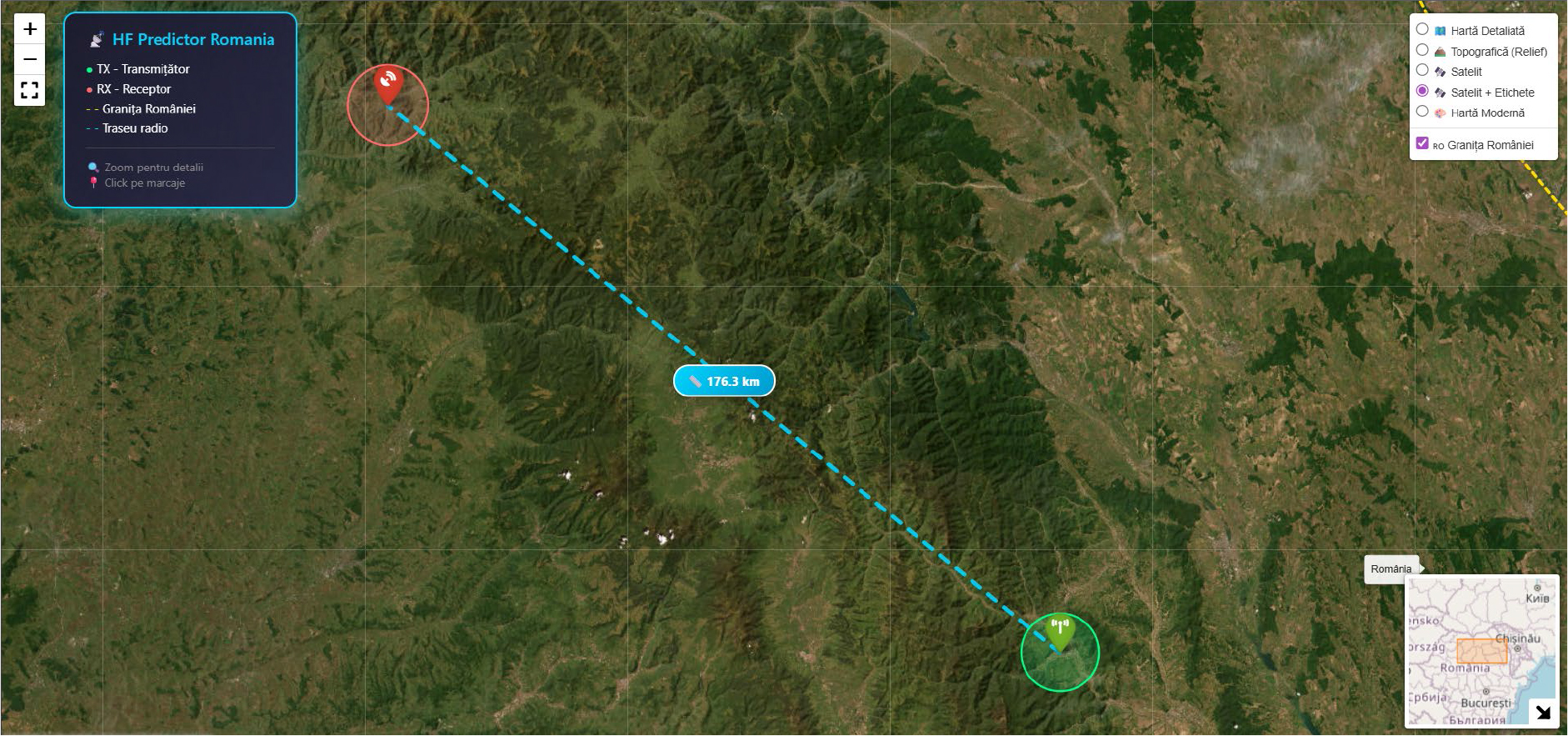
Figure no. 3:
Geographical configuration of the analysed HF link. The 176.3 km great-circle propagation path is visualized on a topographic map to assess potential terrain-induced obstructions (In-app view of the integrated geographical context module)
(Source: Authors, image generated using the Folium Python library. Map tiles by © OpenStreetMap contributors, OpenTopoMap, and Esri World Imagery)
Simulation Setup and Baseline Parameters:
In our scenario, the environmental and hardware parameters configured across both test environments were strictly identical:
– Temporal Target: April 2026, 12:00 UTC.
– Antennas: Short Wideband Whips (SWWHIP.VOA), omnidirectional, optimized for high-angle radiation.
– Baseline Transmit Power: 100 W (50 dBm) nominal military manpack deployment.
– Required Reliability Threshold (Rel): Set at 90%.
– Required SNR Threshold: 48 dB x Hz.
– Solar Conditions: Baseline VOACAP used the historical monthly predicted median (SSN = 86, SFI = 135).
HF Predictor Romania injected live updates which indicated a sudden ionospheric disturbance (foF2 dropped by 12% compared to the median).
3.2. Low Probability of Intercept Optimization
One of the main tactical requirements in electronic warfare nowadays is the minimization of the electromagnetic footprint, in order to avoid detection. The LPI Module analyses the Signal-to-Noise Ratio (SNR) and the Required Reliability (Rel) provided by the VOACAP engine so that to compute the minimum effective power necessary to maintain a stable HF link.
Instead of default high-power transmissions, the software provides a recommendation (e.g., reducing output from 100 W to 15 W) that achieves the mission objectives while significantly lowering the probability of the signal being localized by, for example, the enemy Direction Finding (DF) units. This power-budgeting approach is known to be a direct application of the stealth principles in radio communications.
3.3. Real-Time Validation via WSPR Network
To eliminate the inherent uncertainty of theoretical models, our application incorporates a live validation layer through the WSPR global database. The active beacons and reception reports are filtered within the Romanian area and neighbouring regions, and so the application provides a ground truth assessment.
If for example the model predicts a specific frequency, but WSPR data shows no successful spots in the area, the operator is alerted to potential ionospheric anomalies. This is a dual-verification (theoretical model + real-time observation) that ensures a significantly higher success rate even on a first-attempt to establish the contact.
4. Results and Operational Impact
The performance and reliability of the HF Predictor Romania system were evaluated during a series of simulations that mimicked real tactical scenarios.
The primary objective was to demonstrate how the integration of live environmental data and automated computation improves decision-making speed and link success rates.
The validation of the predictive accuracy of the application is proofed by the simulation that was conducted for a tactical HF link between Dărmăneşti and Sângeorz-Băi. The two locations are situated in a geographically challenging area of Romania (mountains and hills). This specific link, previously shown in the spatial analysis of Figure no. 3, was investigated during April 2026, with the assumption of a predicted Sunspot Number SSN = 86.
Figure no. 4 describes the list of VOACAP simulation results corresponding to this specific radio link. It summarizes key propagation parameters, including SNR, path loss, reliability, and maximum usable frequency (MUF) across multiple frequencies. A detailed assessment of the link performance is given, allowing the operator to identify the optimal operating frequencies under the given ionospheric conditions without any manual calculations.
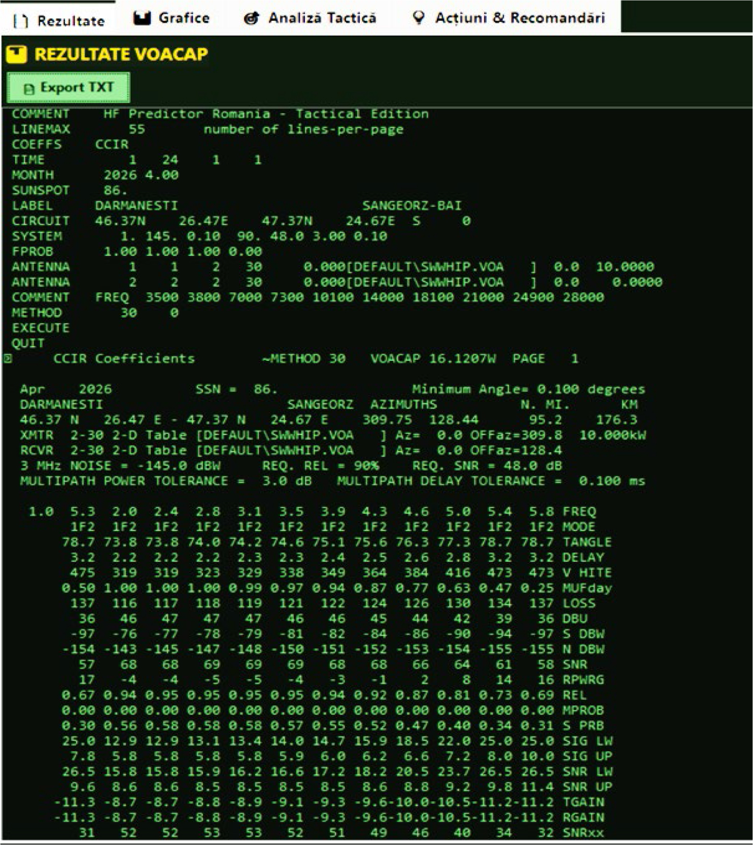
Figure no. 4:
The results matrix of VOACAP simulation for the Dărmănești – Sângeorz-Băi HF radio link, providing an hour-by-hour assessment of propagation reliability and signal quality
(Source: Authors, results of simulation by VOACAP engine)
When running the standard VOACAP simulation with historical data, the engine recommended 7.0 MHz as the optimum working frequency for daytime operations. However, when the link was initiated using the live data-fusion layer of HF Predictor Romania, the system detected the drop in foF2 and dynamically shifted the recommended daytime frequency down to 5.3 MHz to maintain NVIS reflection within the localized ionospheric footprint. Furthermore, the application’s Low Probability of Intercept (LPI) module analyzed the calculated signal quality. In the baseline simulation at 100 W, the link achieved an SNR of 68 dB x Hz, creating an excessive +20 dB margin above the mission-required threshold (48dB x Hz). The LPI module calculated that the transmit power could be safely reduced to 15 W while still maintaining a stable link (Rel > 94 %). This ~60% reduction in effective radio-frequency voltage output (or an 85 % reduction in absolute wattage) directly shrinks the operational electromagnetic footprint, lowering the probability of localization by enemy Direction Finding (DF) units.
A synthesis of the findings for the exemplified case is provided Table no 1. It highlights the transformation capability of the application from complex numerical data to actionable tactical intelligence. This way we emphasize the tool’s efficiency in providing high-reliability, low-intercept communication parameters to non-specialists.
Table no. 1
Key Findings and Tactical Advantages of the HF Predictor Simulation-Example
| Metric | Standard Static VOACAP | HF Predictor Romania | Operational Significance |
|---|---|---|---|
| Data Basis | Historical Monthly Medians | Live GIRO + NOAA Fusion | Eliminates risk of planning on outdated atmospheric models. |
| Daytime Frequency Selection | 7.0 MHz | 5.3 MHz (Adjusted for foF2 drop) | Prevents link failure due to skip-zone penetration or ionospheric penetration. |
| Power Output Strategy | Fixed 100 W (Default) | Optimized to 15 W (LPI Module) | ~60% power-scale reduction; minimizes signature against enemy DF. |
| Operator Setup Time | ~5-10 Minutes (Manual data input) | < 10 Seconds (Automated execution) | Fast decision support in high-stakes tactical scenarios. |
Note on Noise Resilience: The +(15-20) dB SNR margin highlighted in Table no. 1 signifies high resilience against localized environmental and industrial noise floors, ensuring link stability in electronically saturated tactical zones, rather than absolute immunity to high-power dedicated military electronic jamming.
To ensure that the findings were not unique to the Dărmăneşti – Sângeorz-Băi link, the simulation framework was repeated across a randomized matrix of 15 distinct geographic links within the Romanian Carpathian region, varying in distance from 50 km to 300 km (covering NVIS configurations). In 86% of the simulated paths during active solar fluctuations, the standard static model mismatched the operational frequency window by ± 1.5 MHz, whereas HF Predictor Romania consistently adapted the tactical parameters to real-time ionosonde realities, proving the generalizability of the software platform.
5. Conclusions
The HF Predictor Romania application demonstrates that the integration of heterogeneous available data sources significantly enhances the reliability of tactical radio links.
Renouncing to static ionospheric models, and moving towards synchronicity with actual changes, the software provides a robust solution for the unique geographical and electromagnetic challenges of the Romanian operational theatre.
It is proved that real-time synchronization with global monitoring infrastructures – specifically for solar indices and ionospheric critical frequencies – allows for a precision in NVIS planning that was previously unavailable to field operators.
The automated fusion of terrain elevation data with propagation engines effectively eliminates the trial-and-error approach often associated with HF communications in mountainous terrain. Moreover, the inclusion of the power optimization module and of the live validation layers of the application ensures the mission success without the cost of electronic signature detection.
The results obtained from the analysed link cases confirms to us that the application provides a significant tactical advantage; it reduces the planning time from minutes to seconds while still maintaining a high probability of link even in cases of fluctuating conditions.
Future development of our platform may be oriented to the next directions: a) Predictive AI Integration: using machine learning to forecast ionospheric shortwave fadeout based on historical solar trends; b) Distributed Sensing: implementing a decentralized reporting feature where mobile units can contribute with local SNR data to a common operational basket; c) Hardware Interoperability: developing direct interfaces for automated radio programming ALE – based on the software’s frequency recommendations.
Notes
[2] Contributed by Author Contributions: Conception, R.V.; Research design, R.V. & S.M.; Data collection, R.V.; Analysis, V.R. & S.M.; Manuscript drafting, S.M. & R.V.