
1. INTRODUCTION
Still, one of the most difficult and fundamental challenges in engineering design and research is accurately computing coordinates from Global Navigation Satellite System (GNSS) signals in both static and kinematic modes (Karpik et al., 2016; Leick, 2004; Misra & Enge, 2001; Rizos, 1999). This challenge is especially crucial for navigation and geodetic services related to geological and geophysical projects. New satellite equipment offers high-precision measurements in static and kinematic modes, and there are various software packages that focus on GNSS data post-processing. However, choosing the optimized software for a specific geodetic problem remains a key issue. The complexity increases because the data processing algorithms in these different software packages are usually proprietary, meaning they function as a “black box” close to the user, with no access to the internal computation techniques.
GNSS positioning accuracy can be influenced by factors such as satellite clock discrepancies, orbital errors, and atmospheric delays. These issues can lead to significant delays in data processing and reduce the reliability of positioning information, especially in real-time applications (Misra and Enge, 2011; Zhange and Ge, 2016). Furthermore, real-time processing of GNSS data presents challenges regarding data latency and accuracy. Processing delays can reduce the timeliness and usefulness of positioning information, especially in applications where real-time precision is essential. For example, autonomous vehicles, precision agriculture, and emergency response rely on highly accurate and timely positioning data to operate effectively (Langley, 1998).
GNSS processing software is generally classified into two categories: commercial and scientific. Scientific software usually originates from universities or research institutions and is designed for professional use, emphasizing high accuracy. In contrast, commercial GNSS post-processing software is typically developed by specialized companies with contributions from experts in geodesy, satellite positioning, and navigation sciences. Commercial software features a simple, graphical user interface and an efficient workflow, making it easier to use and more accessible than its scientific counterpart. Scientific tools, with more advanced settings and a higher level of control, tend to be complex and often require expert input (Amirkhani, 2012). Scientific software is typically defined by an advanced user interface, requires extensive technical knowledge, and is typically far more expensive than commercial ones (Trigubovich et al., 2017).
Within the past 20 years, many scholars have analyzed the efficiency of online processing data for GNSS measurements. Jamieson and Gillins (2018) performed a comparative study of five of the services: OPUS-S, AUSPOS, CSRS-PPP, GAPS, and Trimble RTX by processing 490 static GNSS files of varying lengths (2 to 10 hours) from six passive marks with minimal to moderate multipath interference, using both GPS and GLONASS systems. The coordinates generated by each servicing system were benchmarked against values derived from a high-accuracy campaign-type static GNSS survey. Their results demonstrated that GLONASS observables enhanced horizontal positioning accuracy of the GNSS receiver, on average, lowering RMS error by 17.1% in lower multipath environments and 36.7% in moderate multipath environments.
Tariq et al. (2017) compared the online GNSS processing services OPUS, AUSPOS, CSRS-PPP, and the offline software package Leica Geo Office v8.3 (LGO). They used both static and rapid static observation methods with a total of five observation session lengths: 2, 4, 6, 8, and 10 hours. The processing results across different online services showed no relation to each other when performed on the same observation point. Nevertheless, the authors argued that AUSPOS maintained accuracy and observation duration dependency, whereby longer sessions yielded better reliability. The authors concluded that online processing services achieve millimeter-level reliability at 10 hours of observation time.
Adam (2017) conducted a study examining how to enhance the accuracy of a GPS passive station by employing both online and offline processing techniques. He created 36 sub-files over 5 days of observation from approximately 121 hours of GPS raw data used in the study. Each sub-file contained complete data for 24 hours, 12 hours, and 6 hours, recorded at 1-second intervals. The results indicated that as the observation duration increases, both the horizontal and vertical RMSE decrease. For all sessions and processing services, RMSE for the horizontal and vertical components was lower than 6 mm and 10 mm, respectively.
El-Mowafy (2013) made a comparison of two online post-processing systems (AUSPOS and CSRS-PPP) with four data sets of 1.5, 2-, and 3-hour duration in three different stations. It was found that AUSPOS is accurate to a few millimeters to 2 centimeters for horizontal coordinates and centimeters for vertical coordinates in the static mode, while CSRS-PPP also achieved an accuracy of a few millimeters to 2 centimeters for planimetric positions, but the error in the vertical component was up to a decimeter.
Abd-Elazeem et al. (2011) employed CSRS-PPP to process and estimate single-frequency GPS data differences in the static mode at three independent locations with one hour, one and a half-hour, and two hours at various base lines of 1.6, 7, and 10 km, respectively. As per the study, single-frequency PPP can fix horizontal coordinates with a precision of a few decimeters.
Tsakiri (2008) evaluated the four online GPS processing services available worldwide using data from eight International GNSS Service (IGS) stations. The results showed that, when 24-hour observations were generally repeatable within 1–2 cm, achieved an accuracy of 3–4 cm in recovering International Terrestrial Reference Frame (ITRF) coordinates and when the same dataset was processed by different services, the solutions obtained fates.
Bilgen et al. (2022) investigated the accuracy of the coordinates obtained from online PPP services using the Automatic Precise Positioning Service (APPS), Canadian Spatial Reference System Precise Point Positioning (CSRS-PPP), and magic Global Navigation Satellite System (magic GNSS) PPP services. The results showed that as the session duration increases, the 3D RMSE decreases, and therefore, the position accuracy increases. In terms of 3D RMSE, CSRS-PPP yielded the best results in all scenarios. The recent development of multiple GNSS constellations and PPP techniques has greatly increased positioning accuracy and reduced convergence times. For example, Hou and Zhou (2023) and Li et al. (2022) found that using GPS, Galileo, and BeiDou results in higher reliability and centimeter accuracy.
While there have been many researches done on processing approaches in GNSS and performances of software in these operations, little effort has been devoted toward comparing various software for commercial GNSS post-processing using similar criteria. As GNSS techniques rapidly evolve and many companies start producing GNSS receivers, numerous software tools have been developed to assist data processing. These tools enable users to process and analyze GNSS navigation signals with greater precision and efficiency, becoming essential in various fields such as surveying, logistics, and vehicle navigation for autonomous vehicles.
With the increased number of available software solutions, there is a need to determine the ones with the best accuracy and reliability (Hamidi and Javadi, 2017). The objective of this investigation is to assess the relative performance of various post-processing programs for GNSS data under standard processing conditions. The intent of this research is not to supplant traditional geodetic adjustment techniques but to offer a basis for comparison. In particular, the research concerns testing the performance of the tools and establishing whether they are viable for high-precision applications. It also aims to demonstrate that software program solutions can provide accurate and timely corrections (Teunissen and Montenbruck, 2017). In addition, the research presents the advantages and disadvantages of each software package, providing knowledge about their everyday usefulness for various geodetic and engineering applications.
A systematic comparative study was conducted to evaluate the software programs' positioning capability against the static Precise Point Positioning (PPP) post-processing technique. PPP-derived coordinates were used as a consistent reference framework rather than a substitute for network adjustment. This ensures uniform comparison across all software solutions. The static PPP processing coordinates at 15 IGS sites were converted into local East-North-Height (ENH) coordinates. The transformation accounted for the local system origin and reference coordinate values to allow detailed assessment of positioning accuracy across 2-hour observation periods. The selected IGS stations were randomly assigned to give as balanced international coverage as possible. Experimental results were computed with six off-the-shelf software packages from different manufacturers, each with different release dates, to ensure a representative and realistic comparison.
2. GNSS PROCESSING SOFTWARE PACKAGES
Several computer software packages for GNSS processing were employed in this study. These software were selected because they are both multi-GNSS observation processing and real-time processing capable. The central software packages offer precise point positioning, real-time kinematic processing, and corrective data integration (Kaplan and Hegarty, 2006). The technical characteristics of the evaluated software packages, highlighting key processing capabilities such as ambiguity resolution, atmospheric modeling, and PPP support, which are essential factors influencing positioning performance, were summarized in Table 1 and include the following user guides: GrafNav/GrafNet, Justin, Magnet Tools, Topcon Tools, and Trimble Business Center (El-Rabbany, 2020).
Table 1.
Technical specifications and processing capabilities of the GNSS post-processing software used in this study
| Characteristics | Software | |||||
|---|---|---|---|---|---|---|
| GNSS solution | WayPoint GrafNav | Magnet Office Tools | Leica Geo-Office | Justin | Trimble B C | |
| Developer | Spectra Precession | NovAtel, Inc | Topcon | Leica Geosystems | Javad | Trimble |
| Versions | v3.x | v8.x | v6.x | v8.x | v3.x | v5.x |
| Processing mode | Relative (static) | Relative + PPP | Relative (static) | Relative (static/kinematic) | Relative + PPP | Relative + ppp |
| Supported GNSS | GPS, GLONNAS | GPS, GLONASS, Galileo | GPS, GLONASS, Galileo, BeiDou | GPS, GLONASS | GPS, GLONASS, Galileo, BeiDou | GPS, GLONASS, Galileo, BeiDou |
| Ambiguity resolution | Yes (L1, L2) | Advanced (AR) | Yes | Yes | Advanced | Advanced |
| Atmospheric modeling | Standard (default) | Advanced models | Standard | Standard | Advanced models | Advanced models |
| Network adjustment | Yes | Limited | Yes | Yes | Yes | Yes |
| References | International GNSS Service (2023) | NovAtel (2023) | Topcon (2022) | Leica Geosystems (2022) | Javad GNSS (2023) | Trimble (2023) |
3. STUDY AREA
This study uses GNSS data from several MGEX sites that are found in various geographical locations. The diverse data offer a comprehensive analysis of the position accuracy at different satellite geometries and environmental conditions. The selection of a suitable study area is crucial in GNSS research since it can influence the availability as well as the quality of GNSS signals. The study setting consists of various environments from urban to suburban and rural settings. This variety confirms that the performance of the GNSS solutions can be tested under different conditions, reproducing real-world situations (Elrewiny MF et al., 2024). The information used in this study is derived from different GNSS constellations, for example, GPS, GLONASS, Galileo, and BeiDou.
These sources of data provide a good distribution of coverage and enhance the reliability of the positioning results. Satellite measurements (Raw GNSS data in RINEX format from a subset of MGEX stations), correction information (Precise satellite orbit and clock corrections from the International GNSS Service (IGS)), and atmospheric data for inclusion in the consideration of tropospheric and ionospheric delays are the primary sources of data. Fifteen IGS network stations were selected in this study. The stations have been distributed in different parts of the globe (Figure 1), and their information has been provided in Table 2 (data obtained from IGS MGEX database).
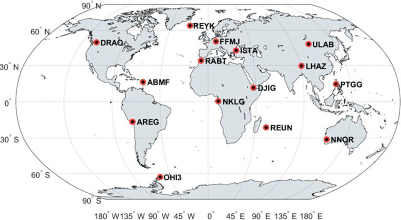
Figure 1.
Geographical distribution of IGS stations used in this study (Bahadur, 2021)
Table 2.
Characteristics of selected IGS/MGEX stations used in the study (Elrewiny MF et al., 2024)
| Station | Country | Receiver | Antenna | Satellite systems | Latitude (°) Longitude (°) | Ellipsoidal Height (m) |
|---|---|---|---|---|---|---|
| DRAO | Canada | SEPT POLARX5 | TWIVC6050 SCIS | GPS+GLO+GAL | 49.323 −119.625 | 542.00 |
| ABMF | Guadeloupe | SEPT POLARX5 | TRM57971.00 NONE | GPS+GLO+GAL+BDS+ SBAS | 16.262 −61.528 | −25.00 |
| AREG | Peru | SEPT POLARX5 | TRM59800.00 NONE | GPS+GLO+GAL+BDS+SBAS | −16.465 −71.493 | 2489.337 |
| OHI3 | Antarctica | LEICA GR50 | LEIR25.R4 LEIT | GPS+GLO+BDS+SBAS | −63.3215 −57.901 | 32.15 |
| REYK | Iceland | LEICA GR50 | LEIR25.R4 LEIT | GPS+GLO+GAL+BDS+IRNSS+SBAS | 64.139 −21.955 | 93.00 |
| FFMJ | Germany | JAVAD TRE_3DEI.TA | LEIAR25.R3 LEIT | GPS+GLO+GAL+BDS+SBAS | 50.091 8.664 | 112.00 |
| ISTA | Turkey | LEICA GR25 | LEIAR25.R4 LEIT | GPS+GLO+GAL+BDS+SBAS | 41.104 29.019 | 147.20 |
| RABT | Morocco | JAVAD TRE_3DELTA | TRM29659.00-SCIS | GPS+GLO+GAL+BDS+IRNSS | 33.998 −6.850 | 90.100 |
| NKLG | Gabon | SEPT POLARX5 | TRM59800.00-SCIS | GPS+GLO+GAL+BDS+IRNSS+SBAS | 0.354 9.672 | 31.496 |
| DJIG | Djibouti | SEPT POLARX5 | TRM59800.00-NONE | GPS+GLO+GAL+BDS+IRNSS+SBAS | 11.526 42.847 | 711.409 |
| REUN | France | SEPT POLARX5 | TRM 559710 | GPS+GLO+GAL+BDS+SBAS | −21.208 55.572 | 1558.40 |
| ULAB | Mongolia | JAVAD TREI3 | JAVRINGANT. GST_NONE | GPS+GLO+GAL+BDS+QZSS+IRNSS+SBAS | 47.865 107.052 | 1575.70 |
| LHAZ | China | LEICA GR25 | LEIAR25.R4_LEIT | GPS+GLO+GAL+BDS+SBAS | 29.657 91.104 | 3622.00 |
| PTGG | Philippines | SEPT POLARX5 | TRM 59800.00-SCIS | GPS+GLO+GAL+BDS+QZSS+IRNSS+SBAS | 14.535 121.041 | 84.900 |
| NNOR | Australia | SEPT POLARX5TR | SEPCHOKE_B3E6-NONE | GPS+GLO+GAL+ BDS+QZSS+IRNSS+SBAS | −31.049 116.193 | 234.984 |
All station coordinates are expressed in decimal degrees, and heights represent ellipsoidal heights referenced to the WGS84 ellipsoid (https://igs.org/mgex/data-products/).
4. METHODOLOGICAL FRAMEWORK
The methodological framework presented in this study consists of four main stages: data acquisition, data preparation, GNSS data processing, and statistical analysis. Data collection involves setting up GNSS receivers at selected locations within the study area to collect satellite observations. GNSS observation data were collected from 15 MGEX stations over 12 days, with 24-hour continuous observations at 30-second intervals. The raw observation data included signals from different satellite systems. For detailed analysis, the 24-hour RINEX files were divided into 2-hour segments using RINEX file splitting techniques, which ensure manageable data sets for processing and analysis. The steps are as in Figure 2.
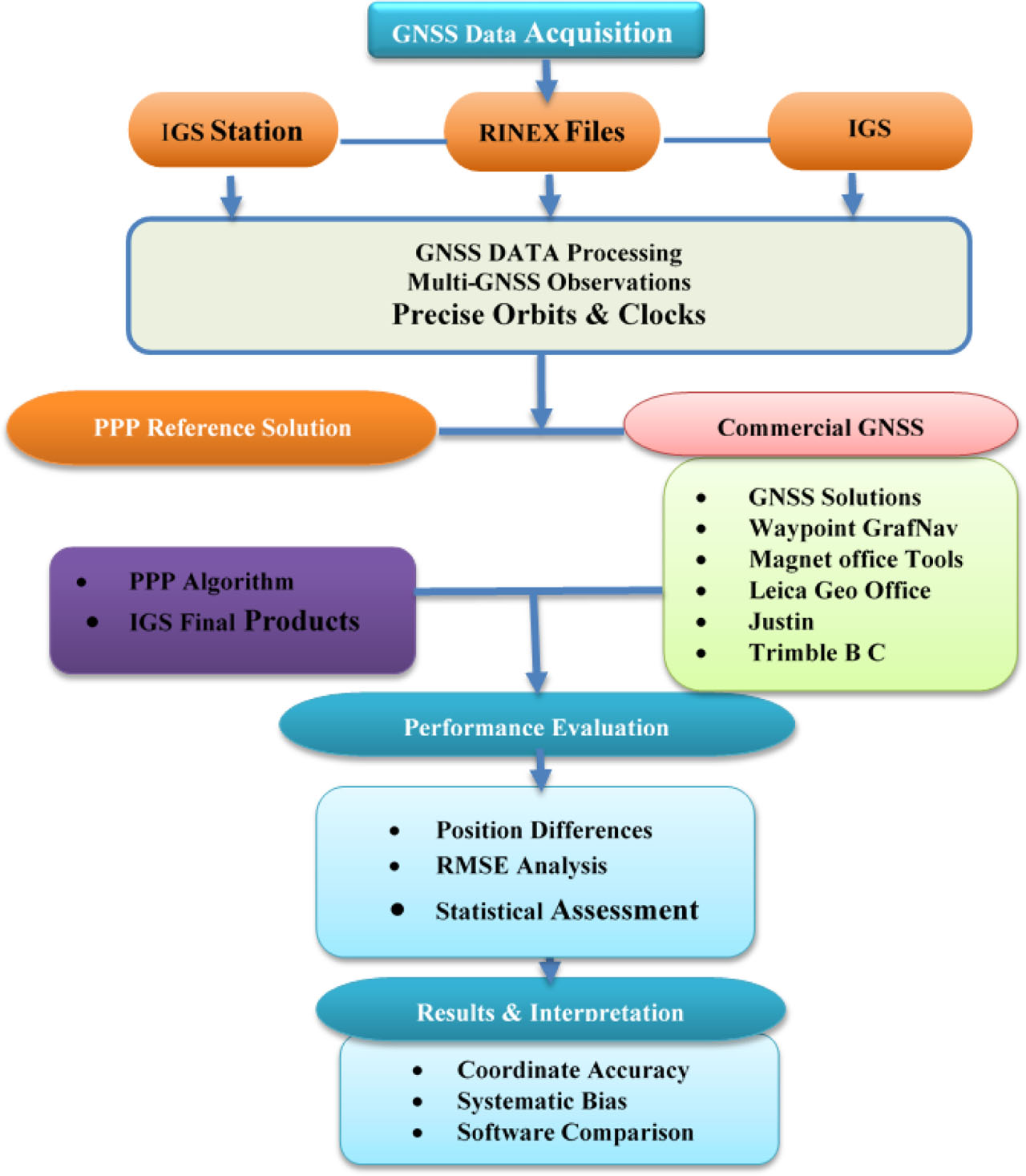
Figure 2.
GNSS data processing workflow
Processing strategy
GNSS data were processed through six different commercial software packages, all under uniform processing conditions, as far as possible. The following processing options were used:
satellite constellations: GPS and GLONASS;
elevation mask angle: 10°;
type of observations: Dual-frequency carrier phase observations;
orbital and clock products: IGS precise orbit and clocks (final products);
reference system: ITRF (define epoch, e.g., ITRF2014 epoch 2010.0);
phase center correction models: IGS standard antenna models (ANTEX);
ionospheric model: First-order ionospheric delay removed using dual-frequency combination;
tropospheric model: Default atmospheric model used in each software package (i.e., Saastamoinen or Hopfield models based on software implementation);
ambiguity resolution: Depends on software (automatic ambiguity resolution, if applicable);
elevation weights: Default elevation weights used in each software package.
It is to be mentioned that the application of default atmospheric models and processing techniques represents a typical user procedure. Although software implementation details might introduce some differences into processing outcomes, the use of precise orbit and clock products from IGS is consistent with modern PPP processing strategies as reported in recent studies (Wang et al., 2024; Nagib et al., 2024).
It should be noted that some software versions used in this study are not the latest releases; however, they were selected to ensure consistency and compatibility across all processing scenarios.
Reference solution
The calculated coordinates of the stations were compared with reference coordinates computed through the Post-Processed Precise Point Positioning technique. It should be emphasized that PPP served as the common reference basis for all calculations and not as the alternative method of network adjustment. Such an approach guarantees a unified reference basis for assessing the relative quality of different software solutions.
Accuracy estimation
The accuracy of positioning was assessed by converting the computed coordinates into the local ellipsoidal coordinate system. The E, N, and H components represent the differences between the coordinates obtained from each software solution and the reference coordinates derived from the PPP solution. The mean values correspond to the average of these coordinate differences over all observation sessions. The following accuracy measures were computed:
mean error;
standard deviation;
root mean square error (RMSE).
The differences between the coordinates were calculated according to the following formulas:
Histogram analysis was conducted to determine the distribution of positioning errors. The interval was defined based on a statistical principle “Sturges” rule, which is a standardized procedure for defining intervals regardless of the data set size. The proportion of observations within each interval was calculated in percentages.
4. RESULTS AND DISCUSSION
A comparative analysis of the coordinates was performed to evaluate the positioning performance of different software programs using the real-time PPP approach in the static mode. The resulting coordinates from static PPP processing of 15 IGS stations were transformed into ENH coordinates. The transformation considered the origin of the local system and reference values to study the accuracy in 2-hour observation intervals for online service, respectively. The 15 IGS sites covered in this study are shown in Table 1. For every site, 2-hour observation files were reviewed on a 30-second interval for 12 days from the IGS web server. Using the real-time PPP technique in the static mode for RINEX 2, we conducted an extensive study to compare coordinates and assess the positioning performance of each software.
The obtained results are consistent with recent findings in multi-GNSS PPP research, where centimeter-level horizontal accuracy and slightly degraded vertical performance were observed (Hou and Zhou, 2023; Li et al., 2022). Moreover, differences between software packages can be attributed to variations in internal modeling strategies, as highlighted in recent comparative studies (Nagib et al., 2024). The differences between the reference coordinates of IGS stations and the ones obtained by GNSS observation post-processing method using different GNSS programs have been calculated, as well as the mean value and the root mean square error (RMSE) of post-processed defined coordinates (Herbert, 2020).
To evaluate the accuracy of the WayPoint GrafNav software, the standard deviation (STDev) values in the horizontal and vertical planes for each epoch were provided. In other software, each epoch of the processed data was characterized by the internal RMSE in the horizontal and vertical planes. It is important to note that the mathematical algorithms used to assess the accuracy of point coordinate determination in the studied software products are concealed from the user. Therefore, the nature of these evaluations (and the trust placed in them) remains uncertain. The statistics of the differences in coordinates (East, North, and Height) between IGS network stations and various software services for RINEX 2 formats of all IGS stations across all days are presented in Table 3, and in Figures 3 and 4.
Table 3.
The statistics of differences between IGS station coordinates and those obtained by various software programs
| Program | East (m) | North (m) | Height (m) | |||||||||
|---|---|---|---|---|---|---|---|---|---|---|---|---|
| Min. | Max. | Mean | RMSE | Min. | Max. | Mean | RMSE | Min. | Max. | Mean | RMSE | |
| GNSS solution | −0.021 | 0.026 | 0.020 | 0.016 | −0.013 | 0.025 | 0.018 | 0.014 | −0.013 | 0.025 | 0.017 | 0.018 |
| WayPoint GrafNav | −0.002 | 0.015 | 0.010 | 0.008 | −0.006 | 0.012 | 0.008 | 0.007 | −0.009 | 0.031 | 0.025 | 0.024 |
| Magnet Office Tools | −0.003 | 0.018 | 0.012 | 0.010 | −0.002 | 0.016 | 0.010 | 0.009 | −0.005 | 0.028 | 0.022 | 0.025 |
| Leica Geo-Office | −0.026 | 0.034 | 0.022 | 0.025 | −0.030 | 0.028 | 0.020 | 0.023 | −0.035 | 0.028 | 0.021 | 0.027 |
| Justin | −0.016 | 0.024 | 0.018 | 0.012 | −0.012 | 0.022 | 0.016 | 0.016 | −0.010 | 0.0300 | 0.018 | 0.020 |
| Trimble B C | −0.043 | 0.042 | 0.027 | 0.034 | −0.400 | 0.049 | 0.031 | 0.037 | −0.071 | 0.039 | 0.035 | 0.041 |
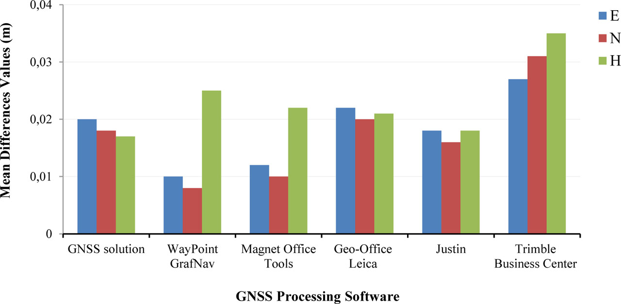
Figure 3.
Mean difference values in coordinates (East, North, and Height) for different GNSS software programs processing used at IGS stations on all days in (m)
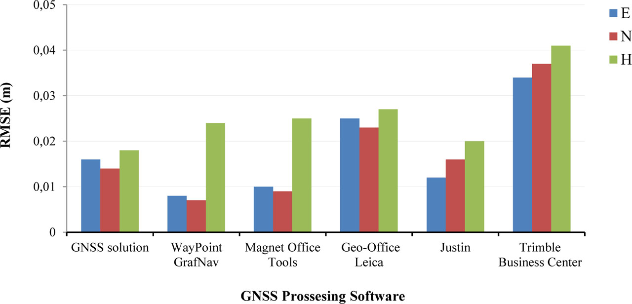
Figure 4.
RMSE in coordinates (East, North, and Height) for different GNSS software programs processing used at IGS stations on all days in (m)
An analysis of the data in Table 3 and Figures 3 and 4 shows that the best GNSS processing software program for determining horizontal coordinates is the Waypoint GrafNav program and Magnet Office Tools. The Waypoint GrafNav program has mean differences of 0.01 m in the East direction and 0.008 m in the North direction, with RMSE values of 0.008 m and 0.007 m, respectively. The Magnet Office Tools program is close in calculating the plan coordinates of points, with mean differences of 0.012 m in the East and 0.01 m in the North and RMSE values of 0.01 and 0.009 m in the same directions. Nevertheless, it is apparent that the vertical positioning has relatively lower accuracy than the horizontal positioning, which can be seen from the differences between the means and the maximum RMSEs, ranging around 3 centimeters and up to 2.5 centimeters, respectively. The GNSS solution program is considered the best for determining the heights of points, as the average differences when calculating the height using the GNSS solution program were approximately 0.017 m with RMSE 0.018 m.
The worst cases of height calculation occur using the Trimble Business Center program, where the average differences in height calculation using the Trimble Business Center program reach 0.035 m with an RMSE of no less than 0.04 m. It is not recommended to use the Leica Geo-Office program in plan coordinates, as it produced a mean error of up to 0.022 m and 0.02 m in the East and North directions, respectively, with RMSE of 0.025 m and 0.023 m in the same order.
These variations that were noticed among the different software tools can also be attributed to the use of default settings in processing, which cause variation due to different implementations of tropospheric modeling, such as the Saastamoinen and Hopfield tropospheric models, the mapping function algorithm, and the technique used for resolving ambiguity.
Analysis of coordinate differences showed that almost all software packages produced positive mean differences. It suggests that systematic errors could be introduced into the GNSS processing chain due to reference frame realization, antenna phase center model, or even orbit/clock products. Such systematic errors were described in the literature recently (Nagib et al., 2024).
With respect to Leica Geo Office, the deviations seen in the outputs have been looked into more deeply. The deviations may be attributed to differences in their processing techniques and how they handle the RINEX file (rather than the manufacturer’s recommended Leica.mdb file). Rather than ignoring the results, they have been kept for analysis to provide a more complete comparison between the software packages.
The coordinates of points obtained by the other software showed differences that were significantly smaller, often matching within millimeters or differing by one wavelength (∼0.02 m). Table 4 presents the RMS values of the coordinate differences of corresponding points from processing in the other software, both in the horizontal plane (mXY) and in height (mH). In this case, the corresponding epoch refers to the same moment in UTC. For further analysis, the results obtained using four software versions that provided the best solutions were selected.
Table 4.
Results of comparing the coordinates of corresponding points obtained through processing in different software
| Software | GNSS solution | Waypoint GrafNav | Magnet Office Tools | Justin | ||||
|---|---|---|---|---|---|---|---|---|
| mXY (m) | mH (m) | mXY (m) | mH (m) | mXY (m) | mH (m) | mXY (m) | mH (m) | |
| GNSS solution | 0.020 | 0.040 | 0.018 | 0.045 | 0.017 | 0.032 | ||
| Waypoint GrafNav | 0.020 | 0.040 | 0.015 | 0.040 | 0.018 | 0.045 | ||
| Magnet Office Tools | 0.018 | 0.045 | 0.015 | 0.040 | 0.019 | 0.055 | ||
| Justin | 0.017 | 0.032 | 0.018 | 0.045 | 0.019 | 0.055 | ||
For all the obtained epochs, the presence of both systematic mutual deviations from each other in the horizontal plane and random errors in the solutions is characteristic. The total deviations of the coordinates of the points from each other in 95% of the cases do not exceed 0.02 m in the horizontal plane and 0.055 m in height. The magnitudes of these deviations were within 0.02 m in the horizontal plane and 0.055 m in height for 97%–99% of the epochs, which is clearly illustrated in the histograms of deviation distributions shown in Figures 5 and 6.
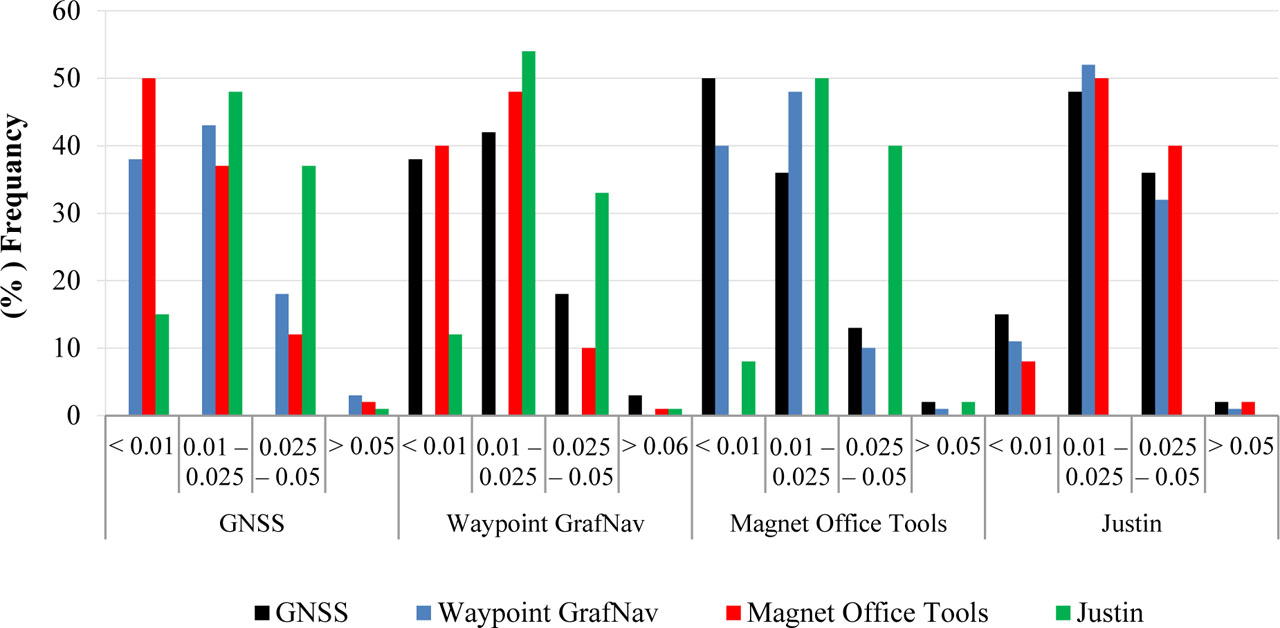
Figure 5.
Statistical distribution of the mean difference values of the station’s coordinates in the horizontal plane of the points processed using different software
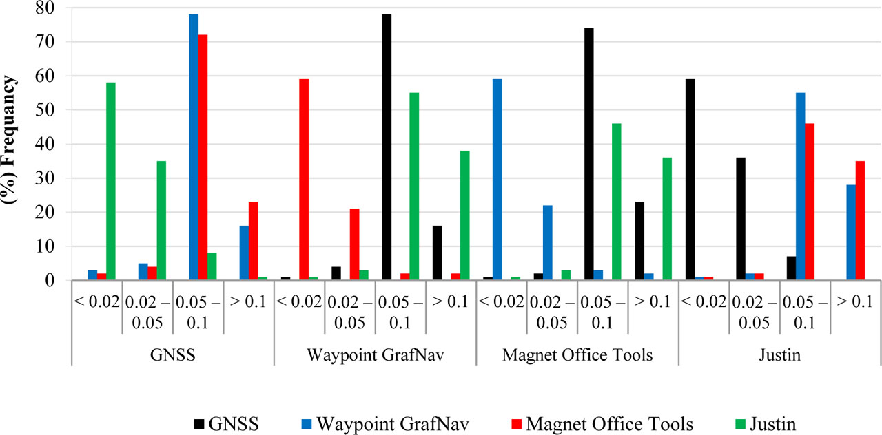
Figure 6.
Histogram of the mean difference values of the station’s coordinates in the heights of the points processed using different software
Based on previous data analysis, histograms of mean difference values of station’s coordinates in plane coordinates and heights of stations processed by different software were obtained (see Figure 7). Thus, it can be stated that the solutions obtained by various software program products for the same session of static measurements can differ from each other by a few centimeters in plan and less than one decimeter in height (in 97%–99% of cases).
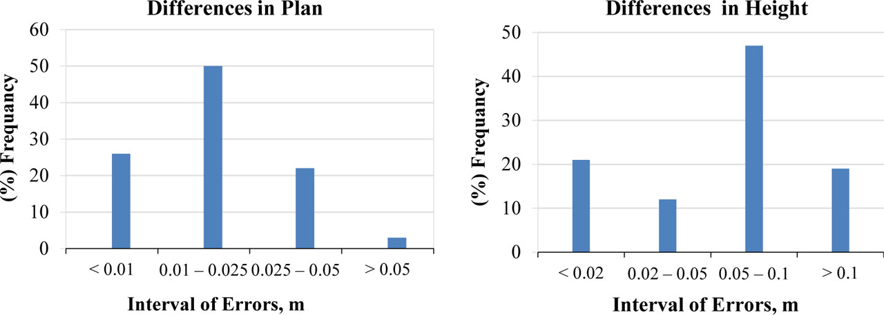
Figure 7.
Summary histograms of the mean difference values in horizontal coordinates and heights of the points processed in the tested software
Therefore, Waypoint GrafNav and Magnet Office Tools show comparable performance, achieving the highest positioning accuracy in plan (RMS = 0.015 m) among the evaluated software packages, but differ significantly in height (0.04 m). The smallest deviations in the obtained heights were observed between the results processed by GNSS solution—Justin; however, the heights of these pairs differed by up to 0.032 m or more.
Although the above information is of high significance, the usage of non-latest software versions can affect the output since modern software offers better algorithms and models than previous versions. Moreover, the test did not take into account the performance of kinematics but focused solely on static positioning. Lastly, the utilization of scientific GNSS software like Bernese or GAMIT/GLOBK would provide an excellent benchmarking platform for the results.
For future work, emphasis should be placed on:
the inclusion of scientific GNSS software for benchmarking,
the performance of kinematic positioning,
time series analysis of positioning errors, and
the effects of different processing techniques in a controlled environment.
In summary, the outcome shows that commercial GNSS software can produce sub-centimeter positioning accuracy in static operations. Nevertheless, the choice of software and processing technique remains significant when it comes to producing accurate positioning measurements.
6. CONCLUSIONS
This study aimed to compare the accuracy of six software programs used for GNSS post-processing. These programs include GNSS Solutions, WayPoint GrafNav, Magnet Office Tools, Leica Geo-Office, Justin, and Trimble Business Center. The comparison was conducted using various Global Navigation Satellite System (GNSS) techniques, such as static and precise point positioning, across different surveying applications. The coordinates obtained through post-processing were averaged to determine the most probable values for each point in the X, Y, and Z directions, corresponding to Easting, Northing, and ellipsoidal height. A total of 15 IGS stations were utilized for this study. The accuracy of each software was assessed using the root mean square error (RMSE) method for data analysis. A series of field observations was conducted to evaluate the performance of various GNSS processing software under different observation modes. The results indicate that this software can provide final coordinates with an accuracy ranging from a few millimeters to centimeters, making them suitable for geodetic applications and analyses.
In the study of the PPP solution for 15 IGS stations, we found that the errors in both East and North directions reached up to 15 mm, with a mean value of 10 mm and an RMSE of approximately 8 mm when using WayPoint GravNav software. The Magnet Office Tools program was the closest software to calculating the plan coordinates of points. In the height direction, the PPP solution errors were up to 25 mm, with a mean value of approximately 17 mm and an RMSE of 18 mm when utilizing GNSS solution software. The results indicate that the standard deviation (SD95%) values were less than 1 cm in the plan and less than 2.5 cm in the height. Based on the results of this paper, it can be stated that the solutions obtained by these software products for the same session of static measurements can differ from each other by a few centimeters in plan and less than one decimeter in height (in 97%–99% of cases).
Based on the research conducted, the following conclusions have been reached:
− The GNSS software solutions, WayPoint GrafNav, Justin, Magnet Office Tools, and Leica Geo Office enabled the collection of data from each station recorded at a measurement frequency of 5 Hz.
− The solution in the Trimble Business Center software was not received. A possible reason is the limited application of the RINEX format in this program.
− In Magnet Office Tools, data processing can take several hours and may result in program crashes, such as freezing or unauthorized terminations that do not provide detailed reports. However, it is possible to proceed without additional issues.
− The Leica Geo Office software successfully provided a coded solution in 87.9% of cases. However, some of these solutions had substantial errors, sometimes exceeding hundreds of meters. It is important to note that this version of the program has limitations when handling non-proprietary measurement formats, as seen with Trimble Business Center.
− The software product WayPoint GrafNav exhibited the fastest processing speed, completing tasks in under 10 minutes. In terms of solution quality, both Justin and WayPoint GrafNav performed exceptionally well, achieving 100% and 94% fixed solutions, respectively. This indicates the high efficiency of these programs in addressing the specified task.
In summary, the research proves that post-processing GNSS commercial software provides centimeter-level precision for static multiple GNSS data, but the choice of software and correct knowledge about its internal processes are necessary to achieve precise results. The results of the research will be useful to surveyors and engineers working on precise positioning using GNSS post-processing software.
Acknowledgements
The authors express their gratitude to the members of the Civil Engineering Department at the Higher Future Institute for Engineering and Technology in Mansoura for their assistance in collecting and analyzing the data.