
1. Introduction
Building complexes in city centres based on urban grids have been subject to processes of architectural transformation over the centuries, while maintaining individual buildings within the framework of the overall structure. The durability of these early urban layouts has conditioned the shape of individual elements [1]. Corner buildings, located at street intersections, hold particular significance in perimeter block development. As Zuzanna Borcz observed, “The very form of the [corner – author’s note] building allowed its significance to be highlighted, which is why many public utility structures (...) were located on corner plots. Similarly, in residential developments, corner buildings often held a higher rank in function by accommodating shops or other services, as well as more expensive apartments.” [author’s translation] [2]. Examples of such projects include Kraków’s buildings like the former Main Post Office and the Press Palace at the intersection of Westerplatte, Wielopole, and Starowiślna streets, the residential building for Jagiellonian University professors at the corner of Słowackiego avenue and Łobzowska street, or the Jubilat department store at the intersection of Krasińskiego avenue and Zwierzyniecka street (Figure 1). All of these buildings are distinguished by both their particular function and architectural form.
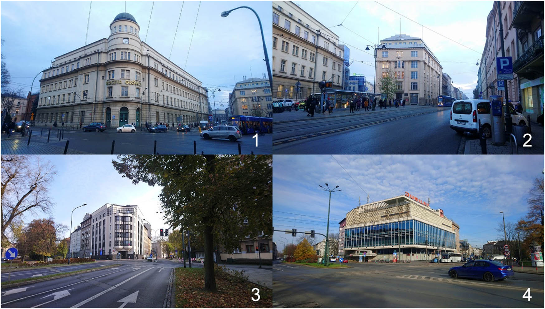
Figure 1
Examples of the corner buildings. (1) The Main Post Office at the intersection of Westerplatte, Wielopole, and Starowiślna streets. (2) The Press Palace at the intersection of Westerplatte, Wielopole, and Starowiślna streets. (3) The residential building for Jagiellonian University professors at the corner of Słowackiego avenue and Łobzowska street. (4) The Jubilat department store at the intersection of Krasińskiego avenue and Zwierzyniecka streets.
Source: Author.
The significance of corner buildings within the urban structure stems directly from their location. Unlike other buildings along neighbouring streets, corner buildings exhibit at least two façades visible from public spaces. They are also often observable from a greater distance. As Przemysław Bigaj noted, “The form of a corner house in an urban block is predestined for originality due to its unique place in the urban structure.” [3]. Street intersections, owing to their communicative function – the crossing of different traffic routes, particularly pedestrian traffic – constitute natural places for people to gather. Both of these factors enhance the attractiveness of such properties. Notably, this relationship applies not only to the most recognisable locations in large cities but can also be observed in small towns or areas distant from main streets.
A natural consequence of such conditions is the need for particular care in shaping the architectural form of these buildings, which involves the use of various solutions, both aesthetic and functional. In many cases, this is emphasised by forms resembling towers or domes, which often means that the buildings serve as dominant or subdominant elements within the urban space.
The individuals directly responsible for the form and artistic expression of buildings are, of course, architects and investors. However, they operate within constraints imposed by law and planning documents. Therefore, planners and the creators of local spatial development plans play a significant role in shaping urban development. They define the guidelines that designers must adhere to, specifying parameters such as allowable height, building coverage ratios, biologically active area ratio, floor space index, and building lines. These guidelines directly affect the possible design volume and, consequently, the architectural form of the building. They should provide architects with the necessary design freedom to construct corner buildings. Continuation of the street front should be enabled in a continuous manner without interruptions (unless dictated by local conditions), while the building itself should reach a height comparable to or even greater than the adjacent structures. At the same time, the width of the building’s plan should be similar to that of other buildings and correspond to its intended function.
In his professional practice, the author has frequently encountered the issue of how local development plans provisions limit the possibilities of shaping corner buildings. He observed guidelines that prevented the design of buildings in accordance with the aforementioned principles. These stemmed from the adoption of identical parameters for the entire development block in the local spatial development plan, without accounting for the specific nature of corner plots. The two schematic examples presented in Figure 2 serve to illustrate this issue.
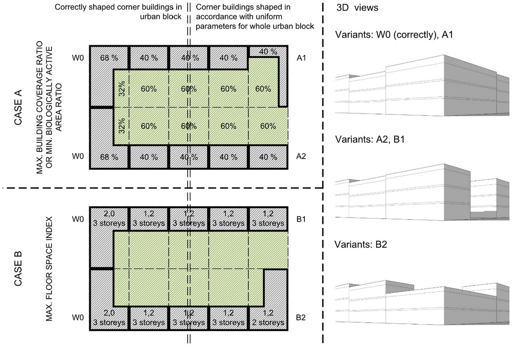
Figure 2
Diagram of the impact of the local spatial development plan on corner building shape. Case (A) shows a situation where a minimum biologically active area ratio or maximum building coverage ratio is defined. Case (B) illustrates the impact of the floor space index on design decisions.
Source: Author.
The first scenario (Figure 2 – Case A) shows a situation where a minimum biologically active area ratio or maximum building coverage ratio is defined. Parameters adopted with linear street plots in mind, when applied to corner plots (where buildings typically have an “L”-shaped footprint), excessively limit the building potential. These plots can result in one of two forms: an incomplete urban block or a narrowed building plan width.
The second instance (Figure 2 – Case B) illustrates the impact of the floor space index on design decisions. Due to the larger footprint of corner buildings (while maintaining the same plan width), their total floor area, with the same number of storeys, will be proportionally greater than that of other plots. Consequently, to comply with the provisions of the local plan, it would be necessary to either reduce the number of storeys compared to neighbouring buildings or reduce the building footprint (as in the first example), which contradicts the often-present vertical emphasis of corner buildings.
Of course, the presented schematics, developed from personal experience, do not exhaust the issue of how local plan provisions affect the architecture of corner buildings. Nonetheless, they inspired the author to undertake broader research on this topic.
The aim of this study is to determine whether the issue in question is widespread and to examine how local spatial development plan authors in Polish cities of varying sizes address this challenge. Solutions that appear to effectively tackle the problem were subjected to in-depth analysis with the intention of identifying best practices for urban planners.
2. State of research
The available literature addresses issues related to the subject of this study. Witold A. Werner [4] discussed the legislative challenges arising from the incompatibility of building regulations and spatial planning laws, particularly in relation to the feasibility of constructing buildings in city centre areas. Wojciech Korbel analysed the extent to which legal regulations influence the creation of public spaces in Polish cities [5] and examined the challenges faced by local authorities in implementing spatial planning policies under the current legislation [6]. Historical attempts to regulate urban development have been explored by Domińczak [7].
Issues concerning the architectural form of corner buildings have been examined by Borcz [2] and Bigaj [3]. Particularly noteworthy is Herriott’s study [8], which provides a detailed analysis of the morphological characteristics of corner buildings. Eminagaoglu [9] investigated the significance of building corners in the perception of urban spatial structure by its users. A similar topic, explored through the urban fabric of Buenos Aires, was discussed by Stalony-Dobrzański [10]. Jacobs, in her book [11], discussed, among other aspects, the importance of street intersections in urban structure and their role within the network of spatial interconnections.
The subject of infilling historical developments, including continuous frontage development and the significance of façades in shaping the city’s image, was examined by Pyrek [12]. A similar topic, with an additional focus on the scale and texture of new buildings within the urban fabric, is addressed by Gleń and Szostak [13]. Krajewska [14] had undertaken an analysis of contemporary infill projects within historic urban fabric, particularly in continuous frontage development, using the example of the Ołbin district in Wrocław. An interesting perspective on functional and architectural solutions in mixed-use buildings across different cultural contexts (New York, Amsterdam, and Kyoto) was presented by Davis [15]. Puła, together with Puła [16], examined the impact of newly constructed buildings in continuous frontage development on the construction of adjacent historical buildings. A broader perspective on contemporary perimeter block development was provided by Bigaj [17] and Twardowski [18].
The reviewed literature highlights the importance of façades in frontage development, repeatedly emphasising the need to carefully consider their architectural expression, particularly when integrating new buildings into existing frontages. Their form significantly influences the perception of users in relation to a given city or district. Several publications also underscore the distinctive role of corner buildings as key elements of the urban structure with exceptional significance. At the same time, some studies identify shortcomings in the Polish legal system concerning spatial planning, particularly in relation to city centre developments. However, despite searches in both Polish and international (English-language) publication databases, no studies have been found that directly examine the impact of local spatial development plans on the possibilities and constraints of shaping corner plot developments. Moreover, the research outlined below indicates that planners’ awareness of this issue is limited, further underscoring the need to address this topic.
3. Research methods
The study consisted of several stages. The first stage involved identifying examples of perimeter block development covered by local spatial development plans. Subsequently, an analysis of the planning provisions for individual blocks was conducted, focusing on regulations directly affecting the area and shape of buildings, such as biologically active area ratios, building coverage ratios, total floor area, floor space index, permissible building height, and building lines. Additionally, attention was paid to local conditions, such as existing development or plot divisions. These requirements were then compared in a tabular summary, highlighting planning solutions that stood out for potentially addressing the problem under investigation. These were subjected to critical analysis based on logical argumentation methods and the author’s professional experience.
As the discussed case pertains to a specific type of urban structure – traditional perimeter block development characterised by division into separate plots – no time frame for their creation was defined at the stage of selecting examples for study. The analysis focused on the provisions of currently applicable local spatial development plans, rather than directly examining the state of existing buildings. For this reason, the age of the structures had a limited impact on the conducted research. However, historical conditions limited their occurrence in most cities to centre areas, often of a historical character (in the analysed examples, buildings or entire complexes were frequently protected under conservation regulations). Modernist urbanism in the spirit of Le Corbusier advocated a move away from intensive street-front development towards more freely shaped layouts, consisting mostly of freestanding buildings which excludes the possibility of their analysis. The contemporary return to perimeter block development in new urban complexes is often associated with large-scale investments encompassing entire urban blocks (where one investor is responsible for the development of the entire block). In the search for examples for this study, publicly available cartographic materials and satellite images were analysed, overlaying them with the boundaries of areas covered by current spatial development plans. Each selected example represents a single block or a continuous street-front development with a corner plot (an incomplete block) bounded by public streets (only one case was analysed per local development plan). A total of 34 examples from across Poland were examined. These include examples from cities of various sizes with areas of perimeter block development.
4. Research findings
4.1. General description of the analysed examples
The analysed local spatial plans frequently employ a variety of provisions to shape development, which can have diverse effects on the development potential of corner plots. In one specific example, involving the Old Town of Kraków, no parameters were specified at all, leaving such decisions entirely in the hands of the conservator. In all other areas, maximum allowable building heights were set, along with at least one additional parameter. The most common practice was to define two indicators. These typically included a minimum biologically active area ratio and a maximum building coverage ratio, or a minimum biologically active area and permissible floor space index. Less commonly, provisions were found specifying all three parameters. In the rarest cases, only the biologically active area ratio or the building coverage ratio was specified. In seven cases, provisions determining the obligatory or non-exceedable building line within a city block were noted.
When examining the provisions of local spatial plans in terms of their impact on development potential, difficulties arose in providing a clear assessment of their effect on corner buildings. Nevertheless, in 16 cases (47%), the described issue was identified. In another eight cases (23%), this issue was also observed, although its scale was mitigated either by the parameters permitting intensive development in the local spatial plan or by other conditions. In nine instances (27%), provisions that solved or came close to solving this issue were noted. In one case (3%), the problem did not arise due to a prohibition on construction work, preventing any new development or the extension or addition of existing buildings. Below are particularly interesting examples of planning solutions that aim to resolve this issue or significantly limit its effects.
4.2. Example from Kraków’s Old Town (No. 18 in Table 1)
Table 1
Summary of all the examples studied
| No. | City | Location (GPS coordinates) | Defined parameters | Other | Problem | |||||
|---|---|---|---|---|---|---|---|---|---|---|
| PZ | PB | I | LZ | Wk | Wm | |||||
| 1 | Brzeg | 50.8587, 17.4583 | 50% | 20% | 1.0–2.5 | — | 5 | 23 | — | Yes |
| 2 | Chełmno | 53.3477, 18.4244 | 80% | 0% | 0.0–45 | — | — | 8 | — | y/n |
| 3 | Gdańsk | 54.4000, 18.6687 | — | 30% | — | — | — | 18 | — | y/n |
| 4 | Gdynia | 54.5169, 18.5421 | 60%/72%n | 20%/0%n | — | Yes | 5/6n | 18/21n | — | No |
| 5 | Gdynia | 54.5103, 18.5391 | 60%/72%n | 20%/0%n | — | Yes | 5/6n | 18/21n | Yes | No |
| 6 | Gliwice | 50.2925, 18.6576 | 70% | 20% | min. 1.3 | — | 5 | — | — | y/n |
| 7 | Jaworzno | 50.2051, 19.2779 | 70% | 10% | — | — | 3 | — | — | y/n |
| 8 | Kalisz | 51.7593, 18.0786 | 40% | 25% | 0.1–0.4 | — | 3 | — | — | Yes |
| 9 | Katowice | 50.2536, 19.0221 | 60% | 5% | 2.4–3.0 | Yes | 4–5 | 23.2 | — | Yes |
| 10 | Kraków | 50.0527, 19.9207 | 80% | 5% | — | — | — | 19 | — | y/n |
| 11 | Kraków | 50.0513, 19.9281 | 60% | 40% | — | — | — | 16 | — | Yes |
| 12 | Kraków | 50.0483, 19.9462 | — | 24% | 0.1–3.7 | — | — | 20 | — | Yes |
| 13 | Kraków | 50.0729, 19.9343 | — | 16% | 2.5–3.5 | — | — | 20 | Yes | No |
| — | 16% | 3.0–5.6 | — | — | 22 | |||||
| — | 16% | 2.5–3.5 | — | — | 20 | |||||
| — | 16% | 4.0–5.0 | — | — | 23 | |||||
| 14 | Kraków | 50.0708, 19.9598 | 40% | 50% | — | — | — | 15 | — | Yes |
| 15 | Kraków | 50.0443, 19.9193 | — | 40% | — | — | — | — | Yes | Other |
| 16 | Kraków | 50.0631, 19.9312 | — | 20% | 1.0–3.5 | — | — | 20 | — | Yes |
| 17 | Kraków | 50.0727, 19.9190 | — | 24% | 1.5–5.0 | Yes | — | 21 | Yes | y/n |
| 18 | Kraków | 50.0623, 19.9340 | — | — | — | — | — | — | Yes | No |
| 19 | Kraków | 50.0437, 19.9483 | — | 20% | 1.0–4.5 | Yes | — | 25 | Yes | Yes |
| 20 | Kraków | 50.0384, 19.9419 | — | 20% | 1.2–4.0 | — | — | 21 | — | Yes |
| 21 | Kraków | 50.0562, 19.9414 | — | 16% | 0.1–4.6 | — | — | 20 | — | Yes |
| 22 | Kraków | 50.0337, 19.9438 | 60% | 15% | — | — | — | 15 | Yes | No |
| 23 | Kraków | 50.0595, 19.9497 | — | 30% | 0.1–3.5 | — | — | 20/25 | — | Yes |
| 24 | Kraków | 50.0631, 19.9459 | — | 16% | 0.1–3.7 | — | — | 22 | — | Yes |
| 25 | Kraków | 50.0473, 19.9532 | — | 30% | 1.35–5.0 | Yes | — | 17 | — | Yes |
| 26 | Łomża | 53.1783, 22.0809 | 50% | 10% | — | — | 2 | — | — | Yes |
| 27 | Łódź | 51.7734, 19.4466 | 85% | 5% | 1.0–4.5 | — | — | 23 | — | No |
| 28 | Mysłowice | 50.2436, 19.1406 | 75% | 10% | 1.1–4.5 | Yes | 6 | 20 | — | y/n |
| 29 | Nowy Targ | 49.4803, 20.0230 | 80% | 20% | — | — | — | 4 | — | No |
| 30 | Opole | 50.6703, 17.9287 | — | 30% | — | — | 5 | — | Yes | y/n |
| 31 | Szczecin | 53.4300, 14.5457 | 60% | 14% | — | — | — | 18.5 | — | Yes |
| 32 | Warszawa | 52.2042, 21.0210 | 60% | 20% | 0.0–2.5 | — | — | 24 | — | Yes |
| 33 | Wrocław | 51.1019, 17.0508 | — | 30%* | — | — | — | 22 | Yes | No |
| 34 | Wrocław | 51.1188, 17.0295 | 80%/85% | — | — | — | — | 25 | Yes | No |
Defined parameters: PZ – maximum building coverage ratio; PB – minimum biologically active area ratio; I – permissible floor space index; LZ – obligatory or non-exceedable building line within the interior of an urban block; Wk – maximum building height in number of storeys; Wm – maximum building height in meters; Other – other parameters or local conditions influencing the development of corner plots; Problem – problem with the possibility of shaping corner buildings; n – applies to corner plots.
Problem: Yes – the problem occurs; y/n – the problem occurs, but scale was mitigated by the parameters permitting intensive development in the local spatial plan or by other conditions; No – the problem does not occur.
* at a distance of 25 m from the boundary lines.
Source: Author’s contribution.
The first example described is unique. It involves a city block located between the Planty Park and Św. Anny, Jagiellońska, and Szewska streets in Kraków’s Old Town. This is the only case (among those analysed) where the local spatial plan does not specify any parameters directly limiting development potential, leaving such decisions to the discretion of the heritage conservator. This provision allows for an individualised approach to each building and plot, taking into account a detailed analysis of its specific conditions. While this approach would be impossible to implement in most cases, it is feasible here due to the exceptional nature of this urban ensemble, which holds unique historical value on a national scale.
4.3. Example from Kraków: Wadowicka-Tischnera Area (No. 22 in Table 1)
Another highlighted example is a corner plot located at the intersection of Łagiewnicka and Grzybki Streets (on the northern side) in Kraków (Figure 3). The local spatial plan stipulates a maximum building coverage ratio of 60% and a minimum biologically active area ratio of 15% for the entire zone, including the corner plot. Additionally, non-exceedable building lines have been established, requiring buildings to be set back approximately 5 m from the boundary of the road plot. This enables the creation of the required green space in front of the building, which is proportionally larger than the courtyard area. This approach helps mitigate the negative impact of unfavourable local spatial plan provisions for corner plots. However, this solution is based on local conditions and does not represent a common urban planning practice – it is the only such case among the examples analysed.
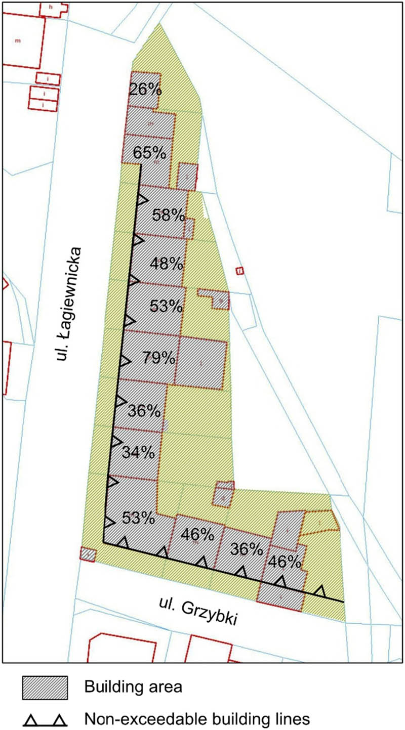
Figure 3
Example from Kraków: Wadowicka-Tischnera Area.
Source: Author, Basemap: https://www.geoportal.gov.pl/.
4.4. Example from Łódź (No. 27 in Table 1)
The next example is from Łódź, located between A. Próchnika, Gdańska, S. Żeromskiego Streets, and 1 Maja Avenue. The city is renowned, among other things, for its tenement houses and accompanying courtyards and gateways. The development of this block, like many others in Łódź, is characterised by very high building density. Front buildings are accompanied by tall outbuildings extending the entire depth of the plot. These structures often form a “U”-shaped layout (with buildings on three sides enclosing an inner courtyard), though some blocks feature buildings on all four sides or form an “L” shape. The local spatial plan for the analysed block allows for a maximum building coverage ratio of 85%, a minimum biologically active area ratio of 5%, and a floor space index ranging from 1.0 to 4.5.
This example demonstrates that adopting very high development intensity or building coverage ratios, combined with a low share of biologically active area ratio, does not restrict the development of corner plots. Although the plan does not specify provisions for corner plots, it allows the continuation of development in its current form (layouts resembling “U” or “L” shapes), enabling flexible architectural design for corner buildings.
4.5. Example from Nowy Targ (No. 29 in Table 1)
Similar solutions were observed in Nowy Targ, between Kolejowa, J. Kilińskiego, A. Mickiewicza and Krakowska Streets. Unlike in Łódź, the development here consists of single-family residential buildings, two to three storeys high, in a continuous frontage arrangement. Satellite imagery analysis shows that the interior of the block is mostly occupied by green spaces. However, the division of plots into narrow, elongated parcels (with front widths ranging from approximately 6.5–15 m) limits the possibility of building outbuildings. Nonetheless, the creators of the local spatial plan adopted similarly high parameters as in the previous example: a maximum building coverage ratio of 80% and a minimum biologically active area ratio of 20%. These guidelines allow for the proper shaping of corner buildings according to their location. However, concerns arise regarding the approval of such intensive development and the potential negative impacts of implementing projects in accordance with these provisions.
4.6. Examples from Wrocław (Nos 33 and 34 in Table 1)
Two examples from Wrocław are particularly noteworthy: the block bounded by the streets gen. R. Traugutta, gen. I. Prądzyńskiego, W. Łukasiewicza, and Miernicza, and the block formed by S. Dubois, Pomorska, Otwarta, and Kurkowa streets. These examples stand out due to their unusual property division compared to other analysed cases. The boundaries of the front plots roughly align with the building outlines, sometimes extending only a few metres beyond the building itself (though exceptions to this rule exist). Inside the blocks, there are separate large plots occupying almost the entire interior.
This property division has a significant impact on the ability to shape corner buildings. All plots, including the corner ones, have nearly 100% building coverage. This allows for the application of identical parameters to all parcels. However, the provisions of the local spatial development plans introduce additional restrictions. In the first location, there is a requirement to maintain a minimum of 30% biologically active area within 25 m from the boundary lines, while in the second location, a maximum of 80% or 85% (depending on the street frontage) building coverage is permitted.
Although this solution is very interesting, it is practically impossible to implement in other locations, as it would require the purchase of often expensive plots, particularly in city centres.
4.7. Examples from Gdynia (Nos 4 and 5 in Table 1)
Further examples come from Gdynia, presented by two blocks: the first situated between the streets Świętojańska, J. Wybickiego, Armii Krajowej, and Grunwaldzki Square (Figure 4), and the second defined by the streets Świętojańska, Żołnierzy I Armii Wojska Polskiego, gen. J. Bema, and Marszałka J. Piłsudskiego avenue. These cases clearly demonstrate the deliberate actions of planners in shaping the permissible development of corner plots. Both local spatial development plans specify parameters for building coverage and biologically active area. In the first plan, the maximum building coverage is set at 60%, while the minimum biologically active area is set at 20%. However, an additional provision states that on corner plots, the building coverage may reach 72%, while no minimum biologically active area is required.
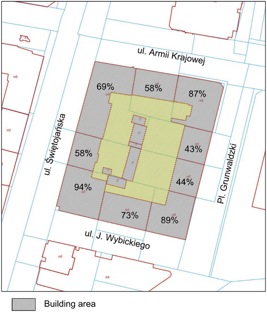
Figure 4
Example from Gdynia.
Source: Author, Basemap: https://www.geoportal.gov.pl/.
At first glance, these parameters appear to be a repetitive and arbitrarily imposed solution, as identical indices are adopted in two different local plans. Moreover, as demonstrated by the analysis of the first block, these parameters are exceeded by the existing buildings. One structure along the street frontage reaches 73% building coverage ratio, while the value for corner plots ranges from 69% to as much as 94%.
Although initially considered by the author as the simplest and most effective solution to the problem of corner plot development, this approach has several significant drawbacks. First, all corner plots must have similar surface areas and proportions (width and depth). Furthermore, separate parameters for corner plots should be calculated individually for each block, rather than uniformly applied across the entire area. A significant challenge also arises from the permissible adjustment of property boundaries. In particular, in the case of land consolidations, it is possible to achieve higher building coverage ratio (across the entire block) than initially allowed by the plan. Theoretically, one cannot rule out the merging of two, three, or even all the plots within a block into a single one. In such a scenario, the interpretation of provisions regarding increased allowable building coverage would become problematic – would a plot encompassing the entire block be considered a corner plot? Since such a plot would have multiple corners, such an interpretation cannot be excluded.
Figure 5 simulates the effects of this approach. The maximum allowable building coverage was assumed to be no more than 40%, and for corner plots, 68%. The first plan presents the expected outcome of such a regulation, maintaining the division into identical parcels. The next two examples illustrate possible development scenarios following the consolidation of all properties. It is possible to create a single building, aligned with contemporary trends, that forms a complete block but with increased building coverage. The following variant shows the potential for constructing a single building (e.g. a shopping centre) with an external car park.
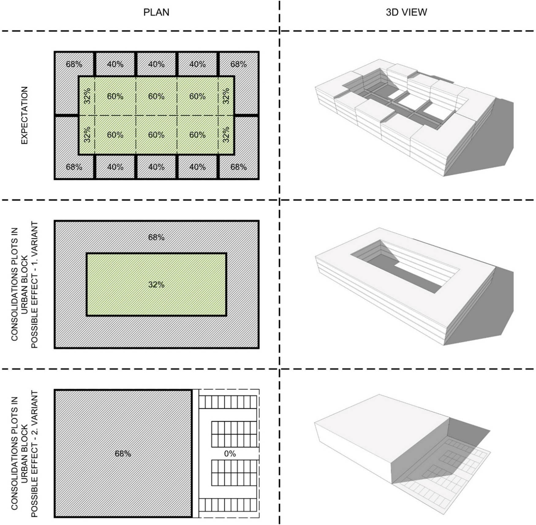
Figure 5
The simulation of the effects of individual parameters for corner plots in a local spatial development plan and the consolidation of all plots in an urban block.
Source: Author.
A similar, purely theoretical calculation was made for the analysed example from Gdynia, located near pl. Grunwaldzki (Figure 4). The surface area of this block is approximately 4,673 m², divided into nine plots. Since the division suggests a probable original subdivision into ten parcels, this layout was used in the calculations. The local plan permits a building coverage ratio not exceeding 60%, while for corner plots, the coverage may reach 72%. A biologically active surface area of no less than 20% is required, except for corner plots, where 0% is permissible. Given this property division, the total allowable building coverage for the entire block (considering the separate parameters for corner plots) is approximately 3,012 m², representing 64.5% of the total area. Simultaneously, the biologically active area should cover at least 588 m² (12.6%). If all plots were consolidated into one and subsequently treated as a corner plot, the building coverage could reach 3,364 m² (72%) – approximately 350 m² more. At the same time, there would be no requirement for a minimum biologically active area.
4.8. Example of Kraków’s Nowy Kleparz (No. 13 in Table 1)
The final case presented here is a block defined by the streets J. Żuławskiego, Długa, and J. Słowackiego avenue in Kraków (Figure 6). This block is characterised by its subdivision into five distinct functional areas within the local spatial development plan. Four of these areas are designated for residential or commercial use, covering the front buildings along with small sections of adjacent courtyards. For all, a minimum biologically active area of 16% has been specified. However, the building intensity indices vary across the different areas and show no tendency for special treatment of corner plots. The interior of the block is designated as green space, where the placement of buildings is prohibited, and the biologically active area must not be less than 80%.
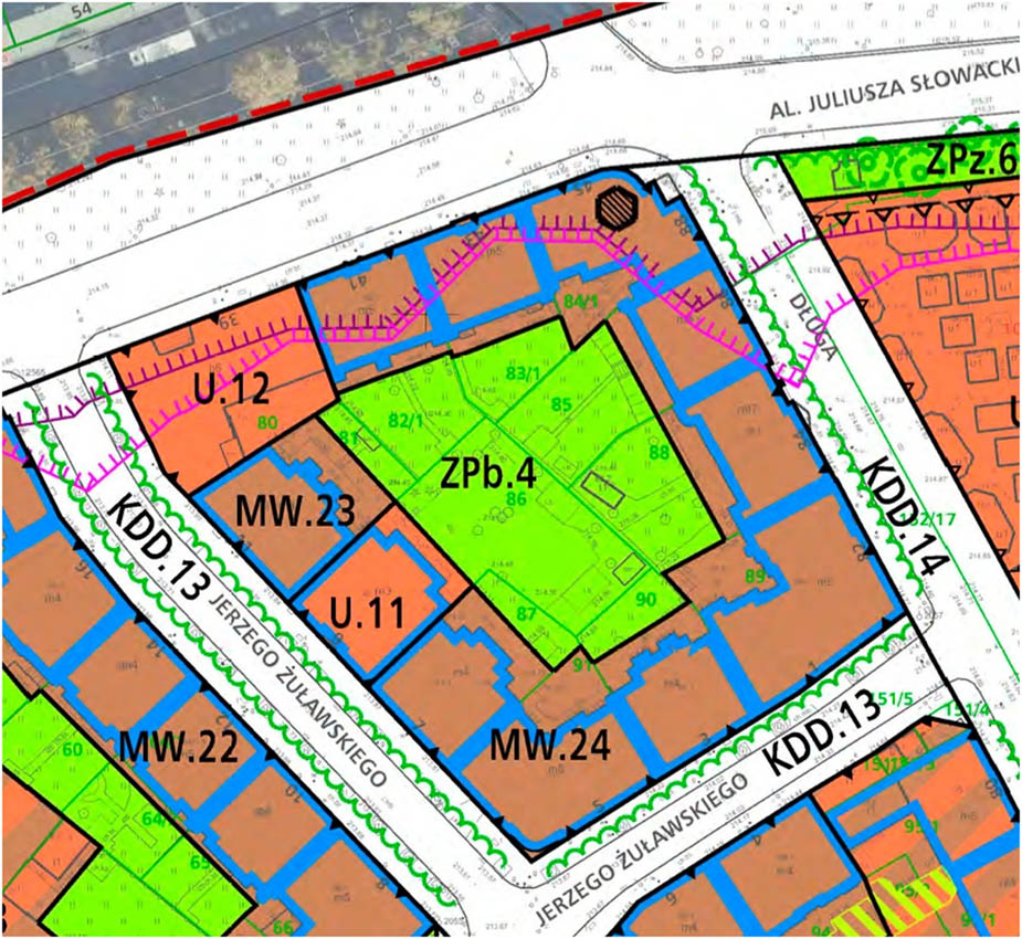
Figure 6
Fragment of the local spatial development plan for Kraków’s Nowy Kleparz.
Source: Miejscowy plan zagospodarowania przestrzennego obszaru „Kleparz”, https://www.bip.krakow.pl/?dok_id=137657 [20.09.2024].
This arrangement does not seem to negatively impact the development potential of corner plots (Figure 7). It requires at least two separate functional areas within a single block. One of these areas, comprising the front building strip with a width similar to the depth of the buildings, could allow for a maximum building coverage of up to 100%, while imposing height restrictions on the buildings. Meanwhile, the block’s interior, depending on the planner’s decision, could either prohibit development entirely or permit it under separate parameters.
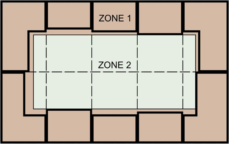
Figure 7
Diagram of the recommended solution for local spatial development plans.
Source: Author.
This planning regulation appears to be universal and applicable to various spatial conditions. Its greatest advantage is its flexibility, enabling the creation of either intensive backlot development (as seen in cities like Łódź) or open, green inner courtyards. It also allows for further subdivision into additional areas – for example, within the front building strip, plots with differing building heights or functional designations could be distinguished. At the same time, it achieves the goal of drafting local spatial development plan provisions that do not excessively restrict the development potential of corner plots.
5. Conclusion
The conducted research confirmed that in Poland, regardless of region or city size, local spatial plans commonly do not account for the specific characteristics of corner plots, leading to excessive limitations on development possibilities. However, some examples were identified where, either intentionally or coincidentally, the provisions helped to minimise or entirely eliminate this issue. The research highlighted the significant impact of local conditions on the effectiveness and quality of various approaches. Solutions such as those from Kraków’s Old Town or Łagiewniki resulted from specific local circumstances and are only applicable in highly particular cases.
The implementation of separate parameters for corner plots, as demonstrated in the examples from Gdynia, appears to be a simple and replicable solution. However, issues like plot consolidation, which can significantly enlarge the area of a corner plot and increase development intensity, raise concerns. The example from Łódź demonstrated that allowing very high building intensity ratios provides flexibility in designing corner buildings. On the other hand, a similar approach implemented in Nowy Targ raises doubts about the potential negative effects of such high-intensity development, particularly in smaller cities.
Finally, the solution implemented in Kraków’s Nowy Kleparz seems to be the most promising and feasible for broader application. In the author’s view, designating separate zones within the local spatial plan for the front building line and the interior of the block does not restrict development opportunities on corner plots, while also preventing excessive development intensity beyond the planners’ intentions. This approach provides planners with greater flexibility and allows for better alignment of plan provisions with local conditions. Based on the conducted study, it is recommended that such solutions be considered when preparing local spatial development plans.
Although the method of developing local land use plans presented above appears effective and universally applicable, further in-depth research is required to find the most efficient solutions to the issue in question. Despite the extensive literature on the role of corner buildings in urban areas, there is a notable lack of publications addressing the legal regulations and planning solutions needed to shape such structures appropriately. In this context, analysing foreign planning systems, particularly in countries with substantial experience in this area, may be especially valuable. Examples from Germany, Austria, Denmark, and the Netherlands may be particularly interesting in this regard and can give an additional perspective, useful in finding appropriate solution on that matter.
Funding information
Author states no funding involved.
Author contributions
The author confirms the sole responsibility for the conception of the study, presented results and manuscript preparation.
Conflict of interest statement
Author states no conflict of interest.
Data availability statement
All data included in this paper.