
Introduction
Lake basins formed in periglacial climates are widely studied due to their cognitive and practical significance. In international literature, the majority of publications focus on the development of thermokarst lakes and their catchments, which form in areas with permafrost, such as Canada (e.g., Bouchard et al. 2020, Coulombe et al. 2022), Siberia (Boike et al. 2015, Séjourné et al. 2015) and Alaska (e.g., Lara, Chipman 2021). These studies present paleoenvironmental reconstructions that document the formation and development of lakes using a variety of methods. Periglacial lakes and their catchments are also studied in other permafrost regions, such as Greenland (Johansson et al. 2015), Spitsbergen (Chernov, Romanshova 2023, Dobrowolski et al. 2025) and Tibet (Niu et al. 2011). Issues related to permafrost waters are also being examined, such as the dynamics of groundwater in permafrost (e.g., Hamm 2023), as well as the hydrological impacts on permafrost thawing and the melting of buried ice blocks and the development of lakes (Błaszkiewicz 2011, Kurylyk et al. 2014, Walvoord, Kurylyk 2016, Szumińska et al. 2017, Brisebois et al. 2025).
The origin of the lake basins in the Łęczna-Włodawa Lakeland has intrigued researchers for the past 100 years, but there is still no definitive explanation for this phenomenon. The first to address the origin of these lakes were Sawicki (1918) and Wołosowicz (1922), who believed that they were remnants of a Pleistocene water body. Wilgat (1954, 1994, 2002) proposed a karst origin for the basins, except deep lakes, whose basins were thought to have formed in subsiding Quaternary sediments lying above active karst features (reproduced karst). A similar view was expressed by Maruszczak (1966), although he attributed the formation of the basins primarily to the activity of subartesian waters.
Further studies, however, showed that some lake basins do not reach the karstified rocks and, moreover, are not located above karst landforms (Buraczyński, Wojtanowicz 1979, 1981, Liszkowski 1977, 1979). Consequently, it was assumed that the lakes were formed because of the melting of dead ice blocks during the Eemian interglacial period (Liszkowski 1979). Buraczyński and Wojtanowicz (1981, p. 17) believed that the lakes could have formed due to the erosive activity of subglacial waters and the melting of dead ice blocks during the Middle Polish glaciation. These authors later proposed a thermokarst origin of the basins, arguing that they formed because of the melting of ground ice and large ice lenses during the last glaciation (Buraczyński, Wojtanowicz 1983, Wojtanowicz 1994). The thermokarst origin of the lakes is also accepted by Harasimiuk (1996). This researcher argued that during the degradation of permafrost, there were significant differences in groundwater circulation conditions and hydraulic pressure. As a result, a hydraulic breakthrough occurred, and large ice lenses formed in the sediments, which later melted during the Late Glacial period. A detailed review of the above-mentioned hypotheses was presented in the monograph on the Łęczna-Włodawa lakes (Harasimiuk et al. 1998).
Issues concerning the origin and development of lake basins were also addressed in publications by Dobrowolski and his collaborators (Dobrowolski 2006, Dobrowolski et al. 2012, 2015). He mainly focused on problems related to the development of lake basins and karst forms in marls and chalk. In an earlier publication, he questioned the karst origin of the lakes in the Łęczna-Włodawa Lakeland, considering it unlikely (Dobrowolski 2006). He also referred to the hypothesis of Buraczyński and Wojtanowicz (1983), expressing the view that the thermokarst origin of lake basins formed in carbonate rocks is not supported by evidence, while mechanical erosion of chalk plays a significant role. The karst origin of the lakes was also challenged by Janiec (2014), based on detailed experimental research concerning the thermochemistry and kinetics of carbonate dissolution.
The review of hypotheses presented above concerning the origin of lake basins in the Łęczna-Włodawa Lakeland indicates a diverse and complex process of their formation. Therefore, this study aims to verify the research hypothesis stating that the basins of deep lakes – Piaseczno, Rogóźno, Krasne and zagłębocze – were formed as a result of hydraulic breakthrough (understood as the disruption of rock continuity by groundwater due to a significant hydraulic gradient) of the impermeable permafrost layer by subartesian and/or artesian waters, as well as by fluvial erosion and denudation processes during the anaglacial phase of the main stadial and the Late Glacial period. Understanding the conditions under which hydraulic breakthroughs occur in permafrost and lead to lake formation is important for future research on the remaining lakes of the Lakeland.
Materials and methods
Numerous research materials were collected using a variety of methods. In preparation for field studies, a review of the subject literature was conducted, along with an analysis of topographic maps at a scale of 1:10,000, as well as geological and geomorphological maps and sketches (Liszkowski 1977, 1979, Buraczyński, Wojtanowicz 1979, 1981, Krawczyk 2021, 2023, Kucharska 2021, 2023) of the areas surrounding the studied lakes. A digital elevation model (DEM) based on Light Detection and Ranging (LiDAR) was also acquired at a resolution of 1 × 1 m.
The field research involved verifying geomorphological sketches developed for the Detailed Geological Map of Poland at a scale of 1:50,000 (Liszkowski 1979, Buraczyński, Wojtanowicz 1981, Krawczyk 2023, Kucharska 2023) using the geomorphological mapping method. In addition, fluvial and organic deposits (peat) in the vicinity of the village of Piaseczno were thoroughly examined based on two outcrops and manual boreholes carried out by the authors using an Eijkelkamp hand auger. These deposits were described in the field in terms of lithology and sedimentology, without laboratory-based soil analysis. Based on data from the boreholes, two morpho-geological cross-sections were prepared. In developing the geomorphological sketch, older data (Liszkowski 1977, 1979, Buraczyński, Wojtanowicz 1979, 1981) were used due to their better alignment of geological units with the landforms.
For four samples of fluvial sediments, the age of deposition was determined using the optically stimulated luminescence (OSL) method at the laboratory of the Faculty of Earth Sciences and Spatial Management, Maria Curie-Skłodowska University (UMCS) in Lublin. The results of these analyses are presented in Table 1. Samples for age determination were collected from outcrops using an ebonite tube approximately 5 cm in diameter and 50 cm in length, which was horizontally driven into selected sediment layers. The samples were then protected from light exposure by wrapping them in opaque foil.
Table 1.
Results of OSL dating of river sediments adjacent to the studied lakes.
| Sample number | Sample name (depth) | Laboratory sample number LUB | 40K | 226Ra | 228Th | Annual dose rate dr | Cosmic dose rate de | Age OSL |
|---|---|---|---|---|---|---|---|---|
| [m] | [–] | [Bq kg-1 | [Gy ka-1] | [Gy] | [ka] | |||
| 1 | Piaseczno P1 (1.3) | 6340 | 117±6 | 1.26±0.21 | 6.81±0.53 | 0.68±0.09 | 16.58±0.45 | 24.75±3.75 |
| 2 | Piaseczno P2 (2.0) | 6341 | 128±5 | 8.43±0.58 | 7.10±0.67 | 0.87±0.10 | 21.88±0.53 | 25.15±2.67 |
| 3 | Piaseczno P6.1 (0.7) | 6428 | 157±6 | 3.06±0.39 | 6.84±0.60 | 0.87±0.11 | 19.44±0.64 | 22.47±2.94 |
| 4 | Piaseczno P6.2 (1.1) | 6429 | 114±6 | 4.42±0.54 | 4.33±0.36 | 0.70±0.10 | 18.37±0.64 | 26.25±3.86 |
Study area
The studied area encompasses four deep lakes (according to Wilgat’s (1954) classification): Piaseczno, Krasne, zagłębocze and Rogóźno, along with their immediate surroundings (Fig. 1). These lakes are located within the Łęczna-Włodawa Lakeland in eastern Poland. The region contains 64 lakes with a surface area exceeding 1 ha. Based on depth, they are classified into shallow and deep lakes (Wilgat 1954). Their distribution is distinctive – they are arranged in narrow zones that correspond to fossil valleys and fault zones, a pattern previously noted by Skompski (1975) as well as Buraczyński and Wojtanowicz (1981).
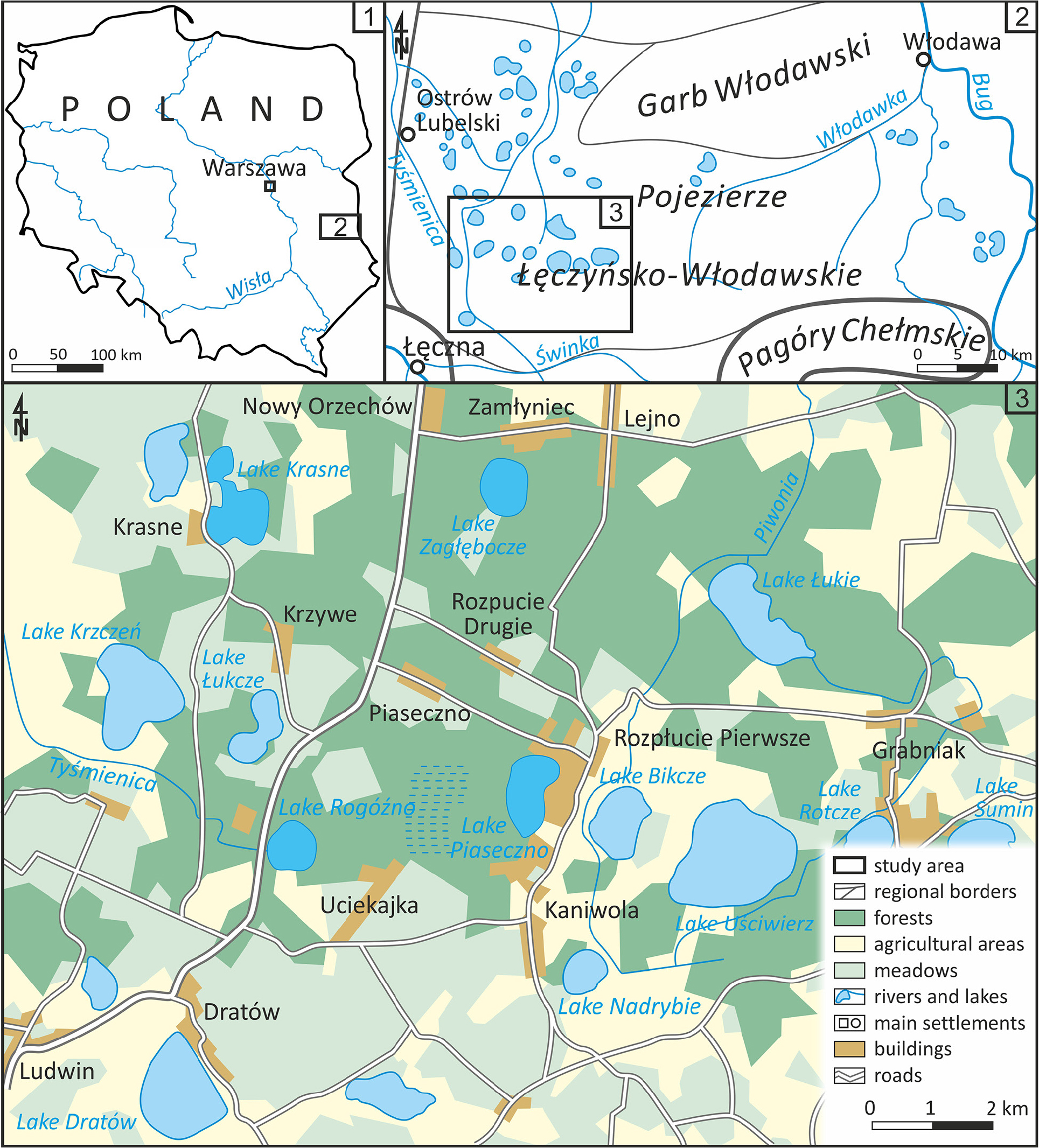
Fig. 1.
Location of the study area.
In the vicinity of the studied lakes, the following landforms are present: lakeland plains from the Odranian and Vistulian glaciations composed of silty sands and silts; a high river terrace from the main stadial of the Vistulian glaciation consisting of sands, in places shaped into dunes; and Holocene peat plains occupying former lake basins (Fig. 2). The Quaternary deposits rest on a substrate of limestones, marly limestones and marls interbedded with chalk, all originating from the Upper Maastrichtian (Krawczyk 2021, Kucharska 2021). The ceiling of these rocks is incised by narrow and deep valleys (with floors around 50 m below the present terrain), running in meridional, latitudinal and diagonal directions, likely formed along normal faults (Fig. 3).
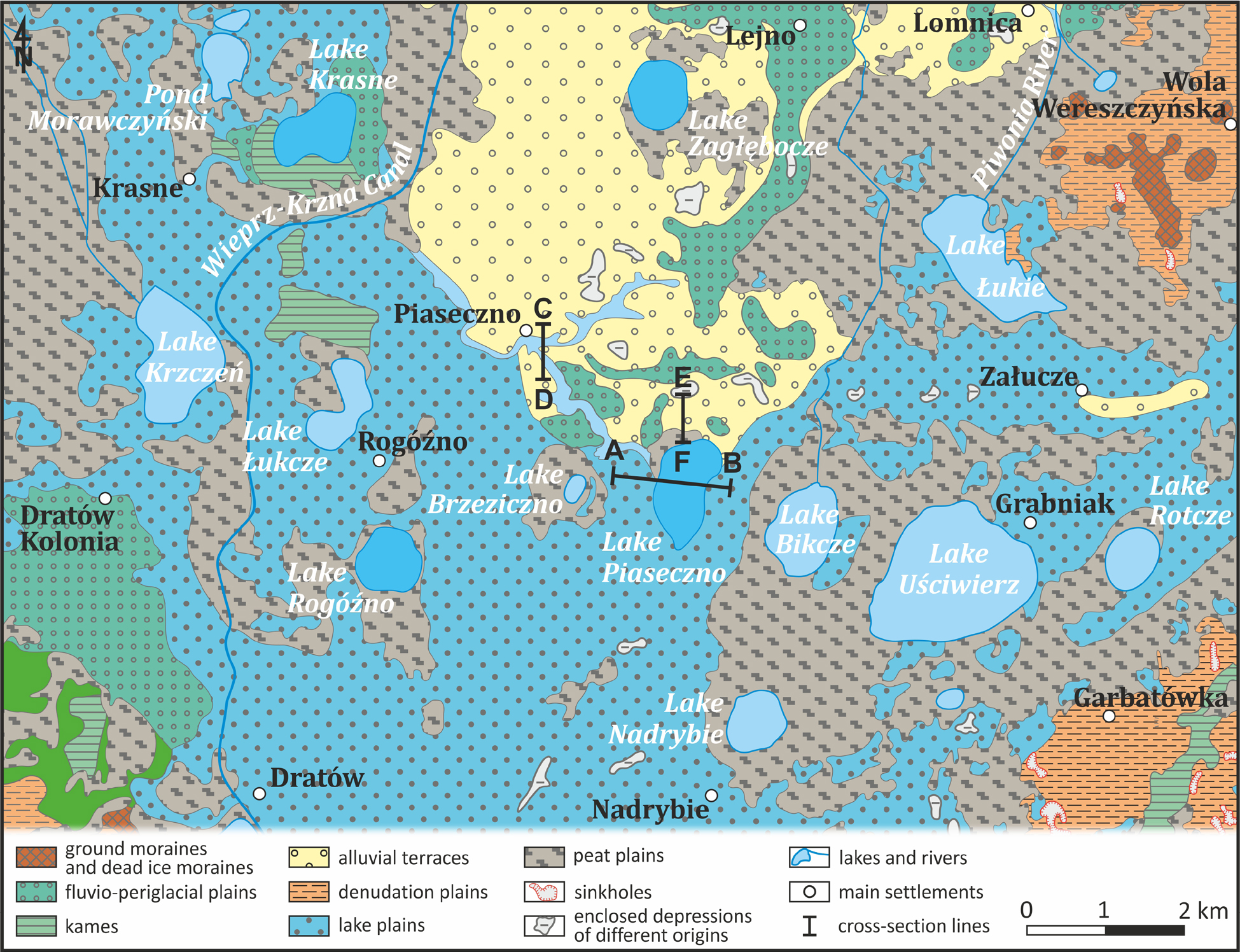
Fig. 2.
Geomorphological sketch of the areas around the studied lakes (according to Liszkowski 1977, 1979; Buraczynski, Wojtanowicz 1979, 1981; Krawczyk 2021, 2023; Kucharska 2021, 2023).
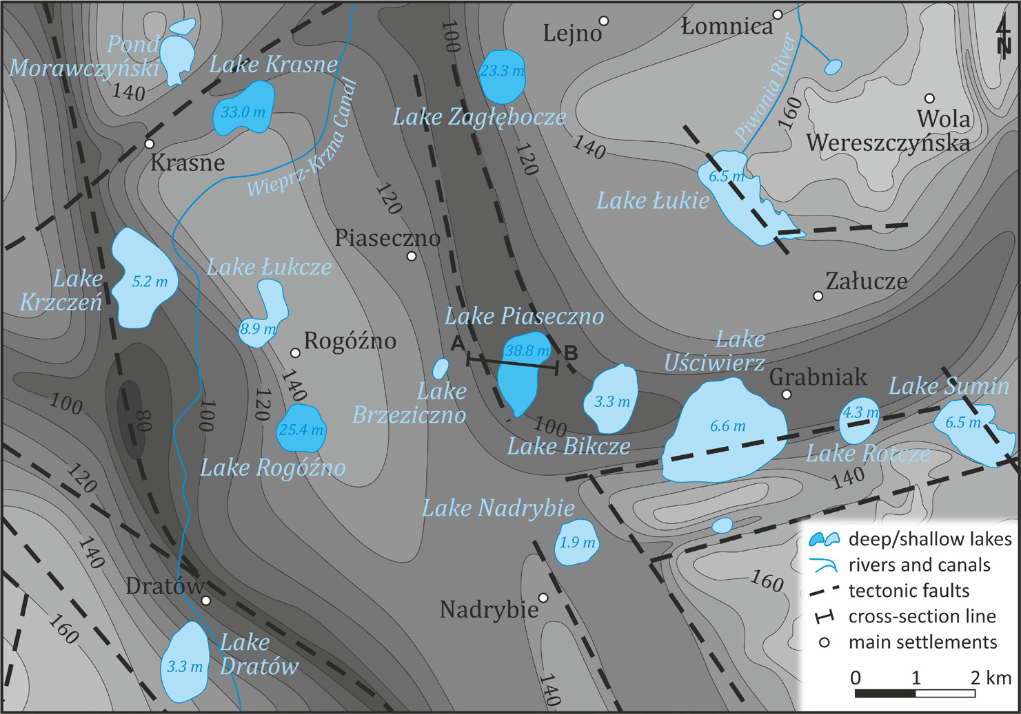
Fig. 3.
The shape of the bedrock surface of the Quaternary sediments (according to Liszkowski 1979; Buraczynski, Wojtanowicz 1981; Krawczyk 2023; Kucharska 2023).
Results
Lake Piaseczno is situated above the junction of two deep, fossil valleys – one meridional and the other latitude in orientation (Fig. 3). In this location, the Quaternary deposits reach a thickness of approximately 72 m and consist of several layers (Harasimiuk 1996, Fig. 4). At the base lies a 40-m-thick layer of sands interbedded with silts and sands containing gravels, partially eroded beneath the lake. These sands are overlain by a layer of clays and silts, which is then covered by sands with gravels. These three layers are attributed to the Sanian 1 glaciation. The ceiling of the profile consists of limnic and fluvial silts and sands from the Vistulian glaciation (Kucharska 2021, 2023).
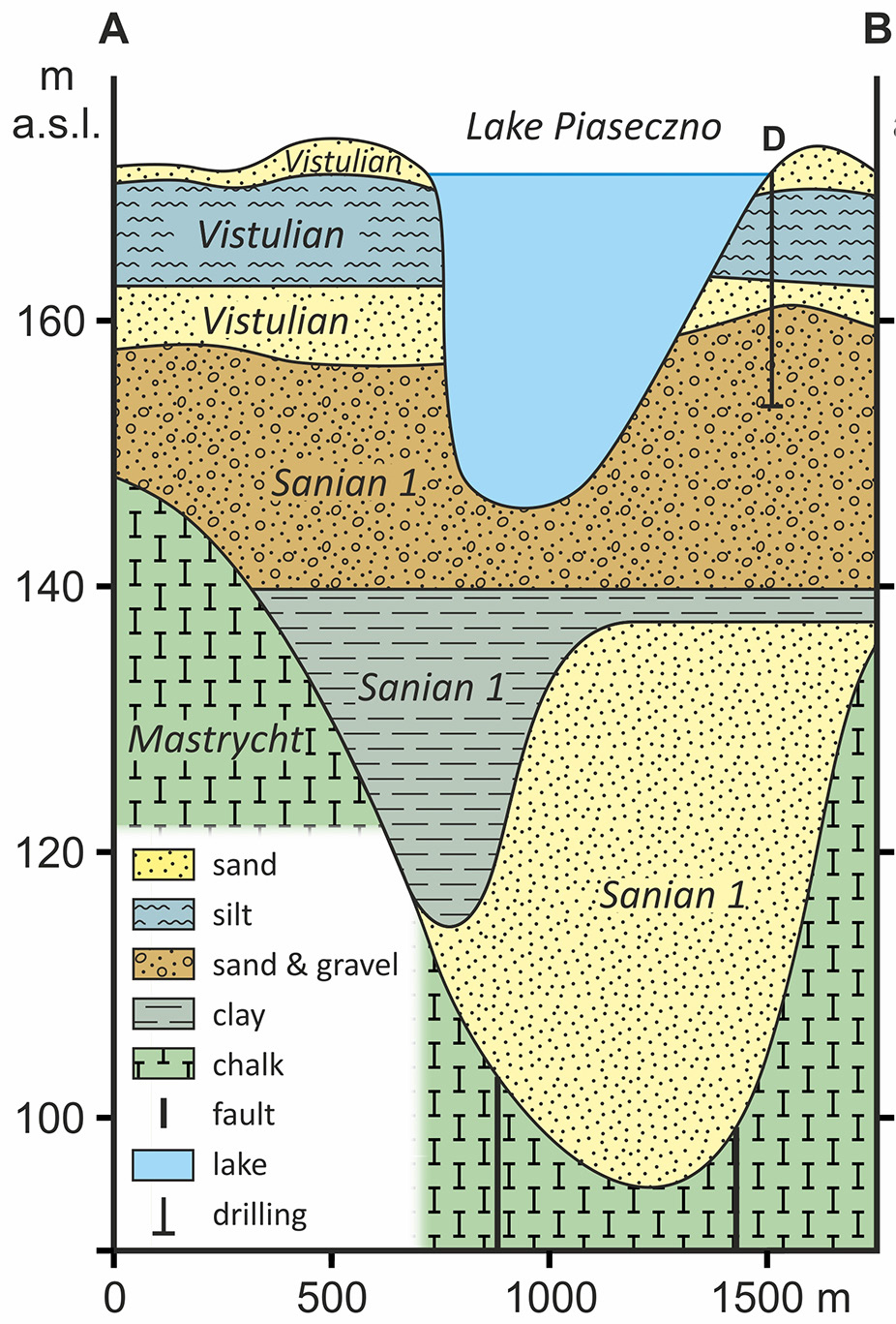
Fig. 4.
Morphological and geological cross-section A–B through the Quaternary sediments of the Piaseczno Lake area (by Harasimiuk (1996, p. 8); sediment stratigraphy according to Kucharska (2023).
The basin of Lake Piaseczno is formed within three main layers: fluvial and lacustrine sands and silts, as well as sandy-gravel deposits (Fig. 5). The northwestern edge of the basin is covered with sedge peat (Fig. 6). Beneath these organic deposits lie sandy sediments in which two incisions extending northward were identified. In the immediate vicinity of the lake, in low-lying areas, fluvial deposits composed of sandy silts are present (Figs 5 and 6). The age of these sediments was determined using the OSL method and it ranges from 22.47 ka to 26.25 ka BP (before present) (Table 1).
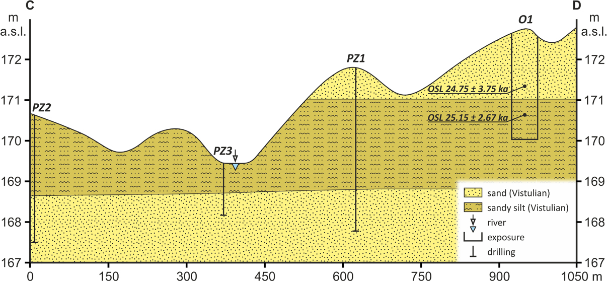
Fig. 5.
Morphological and geological cross-section C–D through the Vistulian sediments of the Piaseczno Lake area.
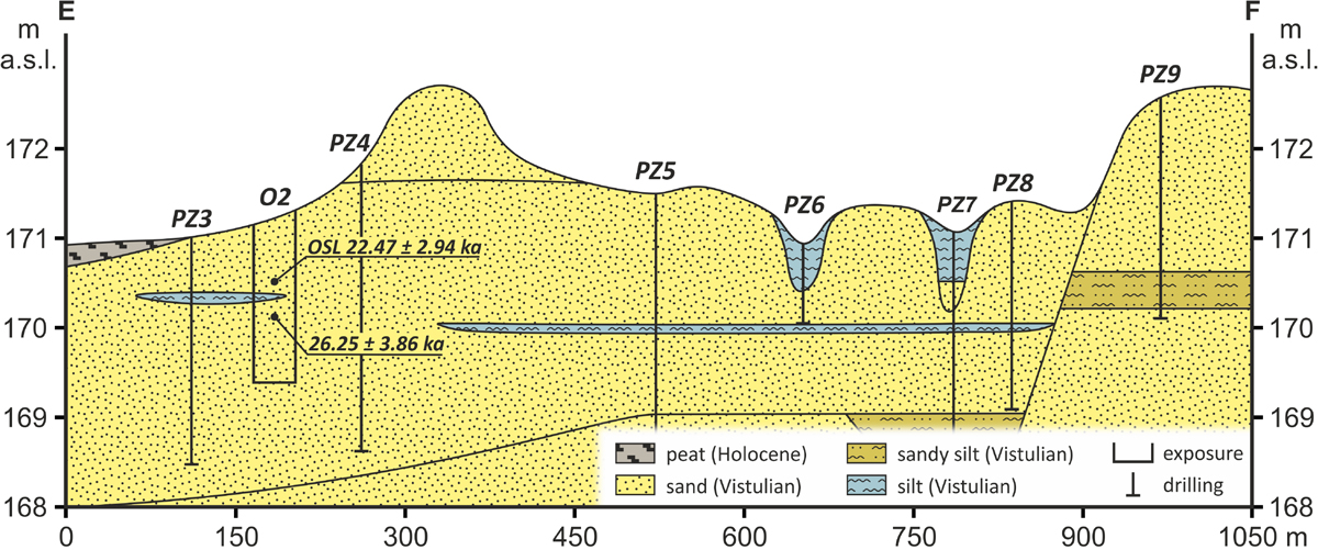
Fig. 6.
Morphological and geological cross-section E–F through the Vistulian sediments of the Piaseczno Lake area.
Lake zagłębocze is located at the upper part of the southern slope of a meridional, deep, fossil valley, several kilometers north of the Piaseczno lake basin. Meanwhile, the basins of the Rogóźno and Krasne lakes are situated near another deep meridional valley (about 40 m deep), located a few kilometers to the west of the previous one (Fig. 3). These valleys are most likely situated in tectonic graben zones or along fault zones.
The bathymetry of the studied lakes is quite distinctive (Wilgat 1954, Wilgat et al. 1991, Michalczyk, Wilgat 1998). The lake basins are shaped like deep funnels, with the Krasne Lake basin consisting of two funnels – one deeper in the east and one shallower in the west, while the Piaseczno Lake basin is elongated (Fig. 7). The lakes exceed a depth of 20 m – the shallowest being Lake zagłębocze (approximately 22.5 m at present), and the deepest being Piaseczno (approximately 38 m at present). The average depths (ratio of volume to surface area) for the two lakes (Piaseczno and Krasne) are relatively large, at 12.6 m and 10.8 m, respectively, even when compared to lakes in the Northern Polish Lakeland Belt (Wilgat 1954). The studied lakes exhibit low relative depth values (from 0.033 to 0.042). The average slopes of the lake basins are also modest, ranging from 3°15′ to 4°55′. The volumes of the studied lakes are among the largest in the Łęczna-Włodawa Lakeland (Table 2).
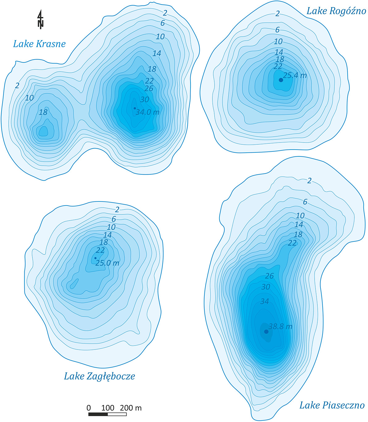
Fig. 7.
Morphometry of selected lakes Łęczna-Włodawa Lakeland by Wilgat (1954).
Table 2.
Morphometric parameters of selected lakes of the Łęczna-Włodawa Lakeland (after: Wilgat 1954, Michalczyk, Wilgat 1998).
| Lake Name | Elevation | Area | Length | Width | Lake shape index | Depth | Volume | Average gradient of slopes |
|---|---|---|---|---|---|---|---|---|
| [m a.s.l.] | [ha] | [m] | [–] | [m] | [1.000 m3] | [–] | ||
| Krasne | 164.0 | 75.9 | 1228 | 856 | 0.50 | 33.0 | 8180 | 4°55' |
| Piaseczno | 170.6 | 84.7 | 1464 | 819 | 0.40 | 38.8 | 10674 | 4°50' |
| Rogóźno | 167.7 | 57.1 | 938 | 846 | 0.65 | 25.4 | 4209 | 3°20' |
| zagłębocze | 166.8 | 59.0 | 942 | 798 | 0.66 | 25.0 | 4279 | 3°15' |
Discussion
The data presented above indicate that the development of the studied lake basins occurred in several stages. The first stage of development involved shallow depressions of unknown origin (Fig. 8A). It is possible that they were formed by fluvial or thermokarst processes during the older stadials of the Vistulian glaciation. Studies based on the sheets of the Detailed Geological Map of Poland 1:50,000 (Liszkowski 1977, 1979, Buraczyński, Wojtanowicz 1979, 1981, Krawczyk 2021, Kucharska 2021) as well as the Geological Map of Poland 1:500,000 (Marks 2022) document extensive areas of lacustrine-floodplain and fluvial deposits from the Vistulian glaciation, covering large areas around the studied lakes. Moreover, Krawczyk (2021, 2023) and Kucharska (2021, 2023) identified narrow, elongated erosional remnants composed of fluvial deposits dated to the Vistulian glaciation. These forms point to intense fluvial erosion, which may have also contributed to the formation of closed depressions. It is also possible that these depressions formed because of the melting of ground ice during older interstadials of the Vistulian glaciation.
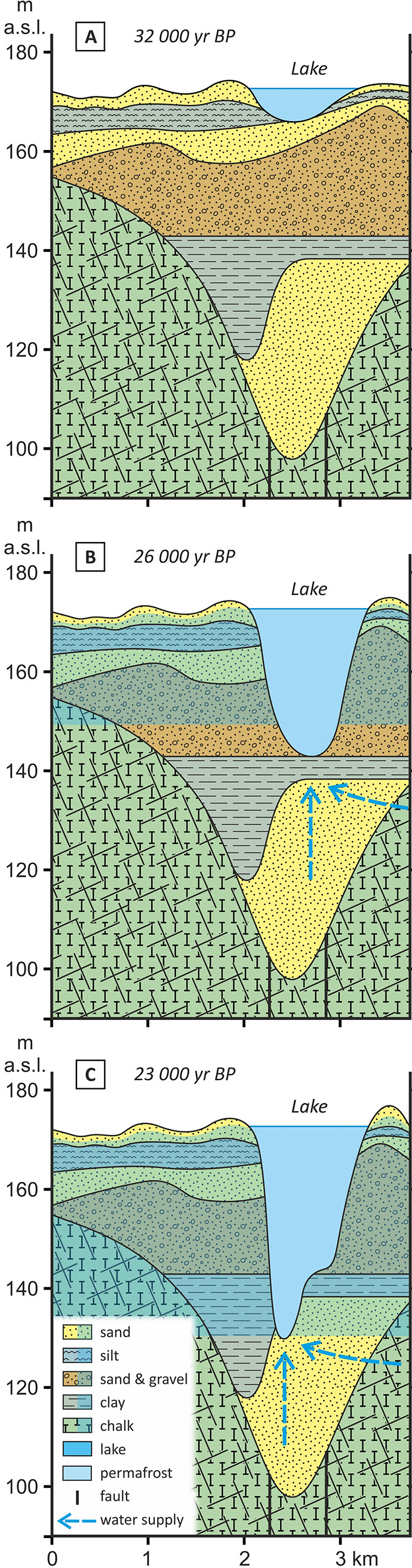
Fig. 8.
Stages of development of the Piaseczno Lake basin (stratigraphy as in Fig. 4).
The lake depressions persisted until the main stadial of the Vistulian glaciation, a condition facilitated by their location near a watershed divide. During the interstadials of this glaciation, groundwater flow in the studied area depended on the arrangement of permeable and impermeable layers, as well as the permeability of fractures in Cretaceous-aged rocks. The recharge areas for underground reservoirs in sandy-gravel deposits were located to the east (near Wola Wereszczyńska) and to the south (near Garbatówka and Ludwin) of the fossil valleys within the crests of Cretaceous rocks, where today several aquifer levels are identified (Buraczyński, Wojtanowicz 1981). Harasimiuk (1996) also suggests that during the Vistulian glaciation, underground reservoirs near the studied lakes were recharged by warm waters from the Lublin Upland. At the onset of the main stadial, the previously loose and permeable rocks became impermeable due to freezing. Permafrost likely began to form immediately after the Denekamp interstadial, remained stable at the cold maximum, and then rapidly degraded in the Late Glacial. In the main stadial, the maximum thickness of permafrost in the studied area is estimated at 90 m (Janiec 2014).
The development of the deep lake basins of the Łęczna-Włodawa Lakeland was recognised using Lake Piaseczno as an example. Before the main stadial of the Vistulian glaciation, there was a closed depression with water in the Lake Piaseczno area (Fig. 8A). This is evidenced by the lake’s catchment area in the form of depression (Fig. 2).
In the ascending phase of the main stadial of the Vistulian glaciation, permafrost began to accumulate in the sediments. The warming effect of lake water and the inflow of deep groundwater contributed to the development of taliks at the surface and within the permafrost, which resulted in its relatively shallow thickness. It is possible that the permafrost contained little ice, and the sediments remained porous. Similar processes are described by Kurylyk et al. (2014) and Walvoord and Kurylyk (2016). Over time, the decreasing thickness of the permeable layer in the sands with gravel contributed to the increasing piezometric pressure of the groundwater. Above the water reservoirs, the permafrost was porous, and additionally, in fault zones, the frozen rocks likely became fractured. In these areas, waters under high pressure, probably laterally constrained by a layer of clay, pierced the thin layer of permafrost, contributing to the formation of first spring hollows (limnocrenes), and then deepening and widening the lake basins (Fig. 8B). Harasimiuk (1996) also considered the role of hydraulic breakthrough in the formation of lakes, although he believed that the main cause of the depressions was the melting of large ice lenses. However, this hypothesis is unlikely because lakes formed in this way are shallow and surrounded by a colluvial rampart (Bobiński 1982, Błaszkiewicz, Danel 2019).
The cause of rock fracturing is difficult to identify. It is possible that neotectonic movements were involved, as Henkiel (1995) believed that such movements occurred even during the Vistulian glaciation on the Lublin Upland. These outflows were associated with significant dislocations in rocks, distinguished by relatively high discharge rates. According to Kowalczyk (2003), fault zones may facilitate vertical flow in a multi-level aquifer system and complicate or block horizontal flow in directions perpendicular to the fault (Haładus et al. 1978). Similarly, in the Podhale region, it has been observed that the closer to fault lines, the more frequent the springs and leaks are (Małecka 1973, Majewski 2013a, b), and water migration is facilitated by the density of tectonic joints (Boretti-Onyszkiewicz 1968).
As the pressure of groundwater increased, subaqueous springs hollows (limnokrenes) expanded and deepened, covering the northern part of the present-day lake (Fig. 8B). The funnel-shaped form of the lake basins and the proximity to fault zones (Figs 3 and 7) may also indicate hydraulic breakthrough. In the case of the basins of three lakes (zagłębocze, Rogóźno, and Krasne), hydraulic breakthrough occurred near faults located in the bottoms and slopes of the glacial, meridional valleys, while in the case of the Piaseczno Lake basin, the breakthrough formed in a tectonic graben at the junction of the meridional and longitudinal glacial valleys (Fig. 3). The role of artesian and subartesian waters in the formation of karst lake basins in the Volhynian and Lublin Polesie regions was also recognised by Tutkovskij (1911), Maruszczak (1966), Harasimiuk (1996) and Dobrowolski (2006). The presence of permafrost in the plenivistulian period forced an increase in hydraulic pressure in the rocks, leading to forced ascension. However, in chalk formations, hydraulic breakthroughs occurred as warming progressed, unlike loose rocks.
After the depression was filled, the outflow of large amounts of water from the lake, in the form of layered floods and concentrated streams, occurred in the northern, northeastern and southern directions (Fig. 9). Traces of these concentrated flows are still visible in the field as narrow, winding and long depressions with no outflow (Figs 2 and 9). The waters carried a significant amount of material from the deepening lake basin and eroded outwash plain deposits, which were deposited in the immediate vicinity. Initially, sandy-silty deposits from the layered floods were laid down, followed by channel sands (Fig. 6). The volume of eroded sediments (approximately 11,000 m3) was sufficient to cover about 5.5 km2 of the area. These deposits are surface bound to the studied lakes, supporting the presented morphogenetic processes. The age of the fluvial sediments was determined to be from the early phase of the main stadial (Table 1, Figs 6 and 7).
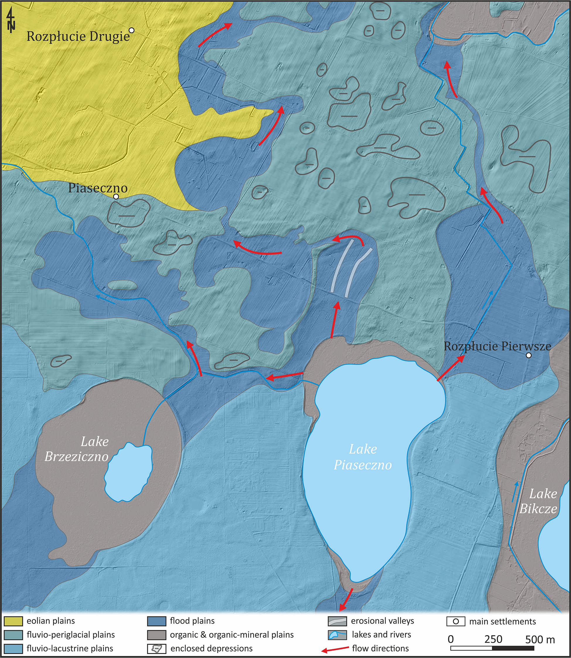
Fig. 9.
Directions of water outflow from Lake Piaseczno during the main stadial.
The development of Lake Piaseczno during the main stadial occurred in two stages, as at a depth of about 25 m, shelves are observed in the slopes of the lake basin (Fig. 7), which are remnants of the lake’s bed from the early development stage. In the second stage, the water-bearing layer in the sands was replenished with water from the slopes of the narrow trench carved in the marl and limestone. These rocks have a different thermal conductivity than the sands, which affected the higher temperature of the rocks and the later freezing of the water (Harasimiuk 1996). Additionally, water in the rock fissures quickly moved to the lower layers, where the rock temperature was above 0°C.
As the sediments were occupied by permafrost, the water was under increasing hydrostatic pressure, eventually leading to the next hydraulic breakthrough next to the existing lake basin, forming its lower, southern part, elongated in the N–S direction (Fig. 8C). Similarly, the basins of Lake Krasne and Lake Rogóźno developed in two stages, while the basin of Lake zagłębocze formed in one stage, as the basin is uniform, without a shelf on its slopes (Fig. 7). At the peak of the cold period (22,000–18,000 years ago), the permafrost likely covered the entire layer of loose Quaternary rocks, contributing to water circulation only in the active layer of the permafrost.
The next stage of development of the studied lake basins is associated with the Late Glacial period. During this time, the thawing of permafrost, progressing from the surface, caused the widening of the basins in their upper parts due to denudation and hydraulic erosion. In places where water outflows of Lake Piaseczno, fluvial processes have started to operate again, by making news deposits. In some areas, the river-floodplain sediments from the main glacial stage were dune-covered, forming aeolian plains (Fig. 9).
Conclusions
Based on the conducted studies, it was found that the deep lake basins of the Łęczna-Włodawa Lakeland were shaped in several stages by diverse processes. Consequently, a new concept for the formation and development of deep lake basins in the region was proposed, which is summarised in the following statements:
The deep lake basins are polygenetic. The oldest, shallow basins have a genesis related to fluvial processes.
In the ascending part of the main stadial, in depressions located above fault zones and fossil river valleys, ascensional springs were formed in frozen but cracked deposits because of hydraulic breakthrough. The waters from these springs filled the depressions, creating shallow lakes. The eroded material was carried out of the lake areas by sheet floods and streams, forming a cover of fluvial sediments.
In the Late Glacial period, because of the melting of permafrost, the lake basins were widened.
The origin and development periods of deep lakes differ from those of shallow lakes.
The novelty of the research on the origin of deep lakes lies in proving that the studied lake basins were formed because of hydraulic break-throughs in permafrost and erosion of sediments, without the formation of ice lenses. The issue of the origin of other deep lakes, as well as the exact extent and volume of sediments removed from the basins, requires separate studies.
Acknowledgements
To the Reviewers, the authors express their sincere gratitude for the constructive comments and suggestions. These have contributed to improving the manuscript.
Notes
[1] Contributed by Authors’ contribution
LF and JS conceived the study and designed the research; JS developed the methodology; L.F. and J.S. collected the field data and drafted the manuscript; L.F. prepared the figures; L.F. and J.S. contributed to writing and editing the manuscript, prepared the responses to the reviewers, and approved the final submission of the manuscript.