
Table 1.
Criteria used for the qualitative and semi-quantitative assessment of the geotourism potential of the study areas and selected sites of geotourism interest (acc. to Kubalíková 2019).
| Criterion | Brief explication | |
|---|---|---|
| Scientific values | integrity | current status of the site or area, degree of degradation of Earth-science features; assessed on the scale from 0 (null) to 1 (excellent); for the areas, the overall landscape quality is assessed |
| representativeness | the site’s or area’s exemplarity; assessed on the scale from 0 (null) to 1 (excellent) | |
| rareness | the existence of features that are unique on the national level; assessed on the scale from 0 (null) to 1 (excellent) | |
| palaeogeographical interest | importance of the site for the Earth or climate history; the sites were assessed on a scale from 0 (null) to 1 (excellent); this criterion was not applied for the assessment of the areas | |
| synthesis | the average of the values (applicable for site assessment) | |
| Added values | ecological | specific or rare species, important ecosystems; assessed on the scale from 0 (no ecological value) to 1 (high ecological value) |
| aesthetical | viewpoints, contrasts, space structuration; assessed on the scale from 0 (no aesthetical value) to 1 (high aesthetical value) | |
| cultural | archaeological, historical, artistic aspects of the area related to geodiversity, anthropogenic landforms; assessed on the scale from 0 (no cultural value) to 1 (high cultural value) | |
| synthesis | the average of the values (applicable for site assessment) | |
| Use characteristics | protection status | legal protection and conservation of the Earth-science features, the sites were assessed on a scale from 0 (no protection) to 1 (Earth-science feature as a subject of protection) |
| threats | risks and hazards: threats to geodiversity — both anthropogenic and natural, assessed on the scale from 0 (existing threats) to 1 (no considerable threats) | |
| accessibility | both by public and individual transport, location of the transport facilities in the proximity (in the case of sites); assessed on the scale from 0 (site with a limited accessibility) to 1 (site with a very good accessibility); for the areas, the “permeability of the landscape” is considered | |
| security | safety and limitations on specific sites, assessed on the scale from 0 (problems with safety) to 1 (no considerable limitations); this criterion was not applied to the area assessment | |
| site context | applicable only on the site assessment | |
| tourist infrastructure | catering, accommodation, shelters, tourist paths leading to the sites, proximity of these features to the specific sites; assessed on the scale from 0 (missing infrastructure) to 1 (present and diverse infrastructure) | |
| interpretive facilities | existing interpretive facilities, promotion of the sites/area, supporting products, and the common knowledge of the area, assessed on the scale from 0 (missing interpretive facilities) to 1 (present and diverse interpretive facilities) | |
| educational | the potential for interpretation, comprehensibility for the lay public; assessed on the scale from 0 (low potential for interpretation) to 1 (high potential for interpretation) | |
| synthesis | the average of the values (applicable for site assessment) | |
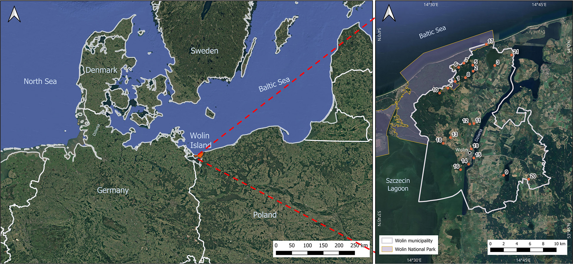
Fig. 1.
Wolin Island location in the southern part of the Baltic Sea; the numbers in the Wolin Municipality indicate the numbers of geosites (see Table 2). (Google Satellite derived from Geoportal 2).
Table 2.
Overview and general characteristics of the assessed geosites.
| Dominant origin | Geosite number | Geosite, coordinates | Brief description |
|---|---|---|---|
| water bodies | 1 | Lake Czajczea N: 53°56'15,180" E: 14°33'25,340" | A post-glacial channel lake with a cryptodepression, hydrologically connected to other lakes of the Wolin lakeland through the Lewińska Struga system. On a peninsula extending into the lake, there are remains of a Slavic stronghold dating back to the 9th–12th centuries. |
| 2 | Lake Kołczewoa N: 53°57'31,980" E: 14°36'21,960" | A post-glacial channel lake with a bottom below sea level, formed within a subglacial channel on Wolin Island. In its vicinity are peat bogs and the remains of a 12th-century Slavic stronghold, highlighting the historical significance of the area. | |
| 3 | Lake Koprowoa N: 53°58'05,700" E: 14°39'24,300" | A lake formed by the isolation of a marine bay, characterised by a muddy bottom and a rich reed belt that constitutes an important bird habitat. It is the largest lake of the Wolin Lakeland and a popular recreational site, with nearby tourist trails for kayaking, hiking, and cycling. | |
| 4 | Lake Rabiąża N: 53°55'34,080" E: 14°33'04,800" | A post-glacial ribbon lake with a cryptodepression, connected to the Lewińska Struga hydrological system. Located within the Wolin National Park, it represents a valuable natural area of tranquil character. | |
| 5 | Lake Reczea N: 53°58'00,600" E: 14°36'21,600" | The deepest lake of the Wolin Lakeland, formed by the melting of dead ice, with a possible meteoritic origin. Its geological structure and isolation emphasise the unique character of this water body. | |
| 6 | Lake wisełkaa N: 53°57'42,800" E: 14°34'20,400" | Formed within a subglacial channel during the Baltic glaciation, the lake is characterised by sandy, gently sloping shores. Surrounded by forests and fields, it is attractive for water recreation and angling. | |
| 7 | Lake zatoreka N: 53°58'07,680" E: 14°35'06,660" | A small channel lake with a bottom below sea level (cryptodepression), surrounded by glacial landforms. Due to its habitat for numerous flora and fauna species, a nature trail with educational infrastructure has been established in its vicinity. | |
| 8 | Lake Żółwińskiea N: 53°56'57,400" E: 14°35'22,500" | The lake fills a post-glacial channel formed during the Vistulian glaciation, with a characteristic meridional arrangement of subglacial troughs. Its morphology reflects the long-term glacial processes of the region. | |
| 9 | Lake Ostrowob N: 53°49'27,300" E: 14°41'58,900" | A shallow channel lake with a maximum depth of just over 6 m, situated on the Gryfice Plain and fed by the Grzybnica River, which also drains its waters into the Kamień Lagoon. Its south-eastern shore borders the Wiejkowski Las nature reserve. | |
| 10 | Łuniewo Reserve,a N: 53°55'33,900" E: 14°32'09,800" | An area comprising raised bogs and a dystrophic lake within a dead-ice depression. It is an important site for biodiversity conservation, accessible through educational paths. | |
| accumulation landforms | 11 | Kame Unińskie Hilla N: 53°53'15,500" e: 14°37'00,900" | It is a fluvioglacial kame composed of sands, silts, and gravels resting on glacial till, formed within an ice-crevasse during deglaciation. It constitutes a valuable example of a glacial landform with significant educational potential. |
| 12 | Mokrzyca Peatlandsa N: 53°53'12,240" E: 14°36'25,920" | Represent an extensive area of reed and tree-sedge peat deposits, exceeding 4 m in thickness. They provide an important habitat for wetland bird species and peatland vegetation, although the terrain is relatively inaccessible. | |
| 13 | Mokrzyca Hillsa N: 53°51'59,610" E: 14°33'53,430" | The Mokrzyca Hills form a moraine complex with diverse relief, created during several phases of glaciation. At the summit lie the ruins of the Żurawice Castle, which combine geological values with historical heritage. | |
| 14 | Wiselców Hilla N: 53°49'55,333" E: 14°36'37,598" | Wisielców Hill (eng. “wisielców" – gallows) is an archaeological reserve containing a barrow cemetery from the 9th–11th centuries, situated on an esker composed of gravel-sand deposits. The combination of geological and cultural values makes this site an important educational point. | |
| 15 | Wolińska Isletb (pl. Kępa) N: 53°50'26,900" E: 14°37'12,600" | A small river islet located on the Dziwna Strait. The proposed geosite is primarily of cultural significance due to the presence of an open-air museum of early medieval architecture and the annually organised Festival of Slavs and Vikings. Because of valuable bird habitats, the southern part of the islet has been designated for protection under the Natura 2000 network. | |
| 16 | Rów Peninsulaa N: 53°49'26,220" E: 14°35'33,900" | It is an extensive, low-lying swamp and peatland area of Holocene origin, associated with the transgressions of the Baltic Sea and the development of deltaic fluvial forms of the Szczecin Lagoon. The area is composed mainly of fen peat and fluvio-marine deposits, displaying features of deltaic accumulation and marked lithological diversity. | |
| geological exposures | 17 | Cliff in Świętouśćb N: 53°59'45,800" E: 14°38'00,600" | The cliff in Świętouść represents an example of an active abrasion coast of the southern Baltic Sea, with well-developed landslide processes and distinct exposures of glacial deposits. It is composed mainly of till, fluvioglacial sands, and gravels, reaching a height of up to approximately 15 m. The site is of high documentary and educational value, as well as possessing aesthetic and landscape significance. |
| 18 | Cliff on the Szczecin Lagoon in Sułominoa N: 53°51'29,488" E: 14°32'56,793" | The southern coast of Wolin Island, along the section between Wolin and Sułomino, is characterised by a well-developed cliff form, reaching heights between 5 and 12 m. The cliff is built predominantly of glacial deposits, including fluvioglacial sands and gravels, as well as till originating from the Pomeranian phase of the Vistulian glaciation. | |
| 19 | Srebrne Hilla and Młynówka Hilla N: 53°51'10,519" E: 14°36'52,322" | Srebrne Hill is an esker formed in a subglacial tunnel, approximately 2 km in length, composed of sand and gravel deposits. The site also holds archaeological significance as the location of a former Wolin settlement from the 9th–12th centuries. In the same area, another geosite – Młynówka Hill – is located, with primarily cultural value due to the remains of a burial ground dating from the 10th to the 12th century. | |
| others | 20 | Cretaceous outcrop in Ostromicea N: 53°48'59,580" E: 14°45'02,580" | It is an accumulation of marls and marly limestones within glacial deposits, which have been subject to exploitation. They were transported by the Scandinavian ice sheet and deposited in their present location during the Vistulian glaciation. The marls and oolitic marly limestones are interbedded with tills containing numerous pebbles and cobbles. The coexistence of deposits of different stratigraphic positions provides evidence of the dynamic nature of sedimentary processes. |
| 21 | Oil well in Zastańa N: 53°59'02,200" E: 14°41'38,700" | The oil well of the Kamień Pomorski oil field exploits the Main Dolomite reservoir, characterised by a porous-fractured structure with high permeability. The deposit is the third largest in the Polish Lowlands and contains sulfur, which affects the specificity of extraction. |
Table 3.
Perceived attractiveness of selected landscapes in the Wolin Municipality from the perspective of inhabitants (1 – very high, 2 – high, 3 – moderate, 4 – low, 5 – very low, – weighted mean, s2w – weighted variance, sw – standard deviation).
| Selected landscapes in Wolin municipality | Percentage of responses [%] | s2w | sw | |||||
|---|---|---|---|---|---|---|---|---|
| 1 | 2 | 3 | 4 | 5 | ||||
| Baltic Sea coast | 70.5 | 20.5 | 9.1 | – | – | 4.57 | 0.42 | 0.65 |
| Areas along the Szczecin Lagoon | 54.5 | 25.0 | 15.9 | 4.5 | – | 4.48 | 0.61 | 0.78 |
| Lakes | 50.0 | 22.7 | 15.9 | 11.4 | – | 4.30 | 0.80 | 0.89 |
| Area adjacent to Wolin National Park | 63.6 | 22.7 | 11.4 | 2.3 | – | 4.11 | 1.10 | 1.05 |
| Areas along the Dziwna Strait | 36.4 | 29.5 | 27.3 | 4.5 | 2.3 | 3.93 | 1.02 | 1.01 |
| The town of Wolin | 11.4 | 18.2 | 36.4 | 27.3 | 6.8 | 3.45 | 1.43 | 1.20 |
| Hills near Mokrzyca Wielka | 22.7 | 27.3 | 31.8 | 9.1 | 9.1 | 3.11 | 1.33 | 1.15 |
| Agricultural areas | 11.4 | 31.8 | 20.5 | 29.5 | 6.8 | 3.00 | 1.18 | 1.09 |
Table 4.
Attractiveness of Polish Geological Institute – national Research Institute geosites (Geostanowiska 2025) in the wolin Municipality from the perspective of inhabitants (1 – very high, 2 – high, 3 – moderate, 4 – low, 5 – very low, – weighted mean, s2w – weighted variance, sw – standard deviation).
| Geosites | Percentage of responses [%] | s2w | sw | ||||||
|---|---|---|---|---|---|---|---|---|---|
| 1 | 2 | 3 | 4 | 5 | |||||
| 6 | wisełka lake | 68.2 | 22.7 | 6.8 | 2.3 | 0.0 | 4.57 | 0.52 | 0.72 |
| 18 | cliff on the Szczecin lagoon in Sułomino | 27.3 | 40.9 | 18.2 | 4.5 | 9.1 | 4.29 | 0.89 | 0.94 |
| 2 | Kołczewo lake | 34.1 | 38.6 | 13.6 | 4.5 | 9.1 | 3.91 | 0.81 | 0.90 |
| 1 | Czajcze Lake | 15.9 | 38.6 | 27.3 | 9.1 | 9.1 | 3.84 | 1.45 | 1.21 |
| 8 | Żółwińskie lake | 20.5 | 38.6 | 18.2 | 9.1 | 13.6 | 3.73 | 1.38 | 1.18 |
| 14 | wisielców Hill | 13.6 | 38.6 | 22.7 | 11.4 | 13.6 | 3.71 | 1.57 | 1.25 |
| 11 | Kame Uniński Hill | 25.0 | 52.3 | 11.4 | 11.4 | 0.0 | 3.57 | 1.89 | 1.38 |
| 3 | Koprowo Lake | 18.2 | 43.2 | 22.7 | 4.5 | 11.4 | 3.52 | 1.39 | 1.18 |
| 16 | Rów Peninsula | 11.4 | 34.1 | 25.0 | 13.6 | 15.9 | 3.52 | 1.43 | 1.20 |
| 19 | Srebrne Hill and Młynówka Hill | 11.4 | 36.4 | 22.7 | 13.6 | 15.9 | 3.46 | 1.61 | 1.27 |
| 4 | Rabiąż lake | 11.4 | 34.1 | 22.7 | 15.9 | 15.9 | 3.43 | 1.29 | 1.14 |
| 7 | zatorek lake | 52.3 | 34.1 | 6.8 | 4.5 | 2.3 | 3.43 | 1.65 | 1.29 |
| 5 | Recze Lake | 22.7 | 34.1 | 20.5 | 11.4 | 11.4 | 3.27 | 1.52 | 1.23 |
| 10 | Łuniewo Reserve | 29.5 | 38.6 | 15.9 | 4.5 | 11.4 | 3.14 | 1.57 | 1.25 |
| 12 | Mokrzyca Peatlands | 22.7 | 34.1 | 25.0 | 9.1 | 9.1 | 3.11 | 1.56 | 1.25 |
| 13 | Mokrzyca Hills | 13.6 | 38.6 | 13.6 | 18.2 | 15.9 | 3.09 | 1.58 | 1.26 |
| 20 | Creaceous outcrop in Ostromice | 9.1 | 27.3 | 22.7 | 20.5 | 20.5 | 2.84 | 1.63 | 1.28 |
| 21 | oil well in zastań | 4.5 | 25.0 | 25.0 | 18.2 | 27.3 | 2.61 | 1.56 | 1.25 |
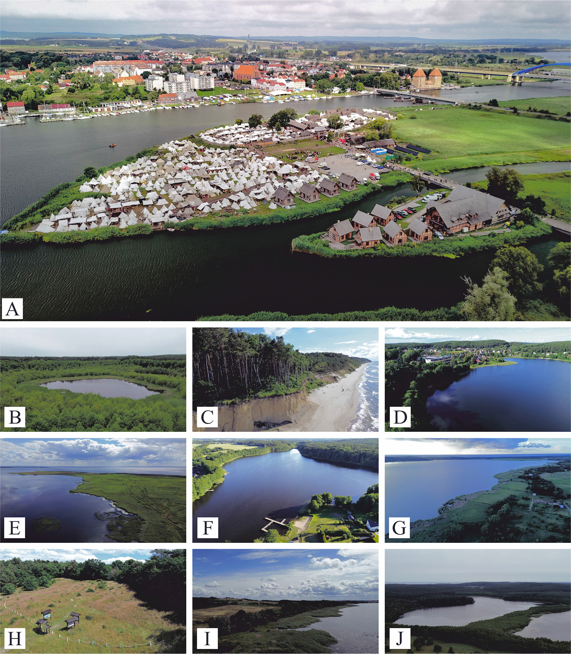
Fig. 2.
Top 10 geosites ranked by expert assessment. A – Wolińska Islet, B – Łuniewo Reserve, C – Cliff in Świętouść, D – lake Wisełka, E – Rów Peninsula, F – lake Kołczewo, G – lake Koprowo, H – Wisielców Hill, I – Cliff on the Szczecin lagoon in Sułomino, J – lake Czajcze.
Source: A: J. niewinczany – wolin City Hall. b–J: own photographs.
Table 5.
Geosites assessment (I – accumulation landforms, II – water bodies, III – geological exposures, IV – others).
| Geosite type | Geosite | Geosite number | Integrity | Representativeness | Rareness | Paleogeographical interest | Total scientific values | Ecological | Aesthetical | Cultural | Total added values | Protection status | Threats | Accessibility | Security | Site context | Tourist infrastructure | Interpretive facilities | Educational interest | Total use characteristics | Geosite score |
|---|---|---|---|---|---|---|---|---|---|---|---|---|---|---|---|---|---|---|---|---|---|
| II | Wolińska Islet | 15 | 0.5 | 1 | 1 | 1 | 0.88 | 0.75 | 0.75 | 1 | 0.83 | 1 | 0.75 | 0.75 | 1 | 1 | 1 | 1 | 1 | 0.94 | 0.88 |
| I | Łuniewo Reserve | 10 | 1 | 1 | 1 | 1 | 1.00 | 1 | 0.75 | 0.25 | 0.67 | 1 | 1 | 0.5 | 0.5 | 0.5 | 0.5 | 0.75 | 0.75 | 0.69 | 0.78 |
| III | Cliff in Świętouść | 17 | 0.75 | 1 | 1 | 1 | 0.94 | 0.75 | 1 | 0.5 | 0.75 | 1 | 0.5 | 0.5 | 1 | 0.5 | 0.5 | 0 | 1 | 0.63 | 0.77 |
| I | Lake Wisełka | 6 | 1 | 1 | 0.5 | 0.5 | 0.75 | 0.75 | 1 | 0.5 | 0.75 | 1 | 0.75 | 0.75 | 0.75 | 0.75 | 0.75 | 0.5 | 0.5 | 0.72 | 0.74 |
| II | Rów Peninsula | 16 | 1 | 1 | 1 | 0.5 | 0.88 | 1 | 1 | 0.5 | 0.83 | 1 | 0.75 | 0.25 | 0.5 | 0.25 | 0 | 0 | 0.75 | 0.44 | 0.72 |
| I | Lake Kołczewo | 2 | 1 | 1 | 1 | 0.25 | 0.81 | 0.5 | 0.75 | 0.75 | 0.67 | 0.75 | 0.5 | 0.75 | 0.75 | 0.75 | 0.5 | 0 | 0.5 | 0.56 | 0.68 |
| I | Lake Koprowo | 3 | 1 | 1 | 0.5 | 0.5 | 0.75 | 0.75 | 1 | 0.5 | 0.75 | 0.75 | 0.5 | 0.75 | 0.75 | 0.5 | 0.25 | 0 | 0.5 | 0.50 | 0.67 |
| II | Wisielców Hill | 14 | 1 | 0.75 | 0.25 | 0.5 | 0.63 | 0.75 | 0.75 | 1 | 0.83 | 0.25 | 0.5 | 0.5 | 0.75 | 0.5 | 0.75 | 0.5 | 0.5 | 0.53 | 0.66 |
| III | Cliff on the Szczecin Lagoon in Sułomino | 18 | 0.75 | 1 | 0.25 | 1 | 0.75 | 0.75 | 1 | 0.5 | 0.75 | 0.75 | 0.5 | 0.25 | 0.25 | 1 | 0.25 | 0 | 0.75 | 0.47 | 0.66 |
| I | Lake Czajcze | 1 | 1 | 1 | 0.5 | 0.25 | 0.69 | 0.5 | 0.75 | 0.75 | 0.67 | 0.75 | 0.75 | 0.5 | 0.75 | 0.75 | 0.25 | 0.25 | 0.5 | 0.56 | 0.64 |
| I | Lake Zatorek | 7 | 1 | 1 | 0.5 | 0.5 | 0.75 | 0.5 | 0.75 | 0.25 | 0.50 | 0.5 | 0.5 | 0.5 | 0.5 | 0.5 | 0.5 | 0.5 | 0.5 | 0.50 | 0.58 |
| II | Mokrzyca Peatland | 12 | 0.75 | 0.5 | 0.5 | 1 | 0.69 | 1 | 0.5 | 0.25 | 0.58 | 0.75 | 0.5 | 0.25 | 0.25 | 0.5 | 0.25 | 0 | 0.75 | 0.41 | 0.56 |
| II | Mokrzyca Hills | 13 | 1 | 0.75 | 0.25 | 0.5 | 0.63 | 0.5 | 0.5 | 0.5 | 0.50 | 0.5 | 0.5 | 0.5 | 0.75 | 0.75 | 0.25 | 0 | 0.5 | 0.47 | 0.53 |
| I | lake Rabiąż | 4 | 1 | 1 | 0.5 | 0.25 | 0.69 | 0.5 | 0.5 | 0.25 | 0.42 | 0.75 | 0.75 | 0.5 | 0.5 | 0.5 | 0.25 | 0 | 0.25 | 0.44 | 0.51 |
| I | Lake Żółwińskie | 8 | 1 | 1 | 0.5 | 0.25 | 0.69 | 0.5 | 0.5 | 0.25 | 0.42 | 0.75 | 0.75 | 0.5 | 0.5 | 0.25 | 0 | 0 | 0.25 | 0.38 | 0.49 |
| IV | Oil well in zastań | 21 | 1 | 1 | 0.5 | 0.75 | 0.81 | 0 | 0 | 0.75 | 0.25 | 0 | 0.75 | 0.5 | 0.75 | 0.25 | 0 | 0 | 0.75 | 0.38 | 0.48 |
| I | Lake Recze | 5 | 1 | 1 | 0.5 | 0.5 | 0.75 | 0.25 | 0.5 | 0.25 | 0.33 | 0.5 | 0.5 | 0.5 | 0.5 | 0.25 | 0 | 0 | 0.25 | 0.31 | 0.47 |
| I | Lake Ostrowo | 9 | 1 | 1 | 0.5 | 0.25 | 0.69 | 0.25 | 0.5 | 0 | 0.25 | 0.75 | 0.75 | 0.5 | 0.5 | 0.25 | 0.25 | 0 | 0.25 | 0.41 | 0.45 |
| III | Creaceous outcrop in Ostromice | 20 | 0.5 | 0.5 | 0.75 | 1 | 0.69 | 0.25 | 0.25 | 0.5 | 0.33 | 0 | 0.25 | 0.25 | 0.5 | 0.25 | 0 | 0 | 0.75 | 0.25 | 0.42 |
| III | Kame Uniński Hill | 11 | 0.75 | 0.5 | 0.25 | 0.75 | 0.56 | 0.25 | 0.5 | 0.25 | 0.33 | 0 | 0.25 | 0.25 | 0.5 | 0.75 | 0.25 | 0 | 0.5 | 0.31 | 0.40 |
| III | Srebrne Hill and Młynówka Hill | 19 | 0.25 | 0.5 | 0.5 | 0.25 | 0.38 | 0.25 | 0.5 | 0.5 | 0.42 | 0.25 | 0.5 | 0.25 | 0.5 | 0.75 | 0.25 | 0 | 0.25 | 0.34 | 0.38 |
| ∑ | 0.87 | 0.88 | 0.58 | 0.60 | 0.73 | 0.56 | 0.65 | 0.48 | 0.56 | 0.62 | 0.60 | 0.48 | 0.61 | 0.55 | 0.32 | 0.17 | 0.56 | 0.49 | 0.59 |