
Introduction
Geodiversity, understood as the natural diversity of geological, geomorphological, soil, and hydrological elements, is a crucial foundation for the development of tourism in many regions of the world (Tukiainen et al. 2022). Its phenomena, from mountain and volcanic landscapes, through river valleys, lakes, to geomorphological forms in urban areas, create unique spatial identities that attract visitors and generate various forms of tourism activity. In this context, geodiversity is increasingly seen not only as a scientific and educational resource, but also as a factor driving tourism development and building territorial brand (Rutherford et al. 2014).
The coastal landscapes are among the environments where geodiversity plays a particularly significant role (Drinia et al. 2021, Morante-Carballo et al. 2023). Coastal areas shaped by marine and river processes offer characteristic landforms such as cliffs, dunes, spits, and deltas, which in themselves are tourist attractions (Kocyła, Rumiński 2004). The landscape and educational potential of these forms contribute to the development of tourism in coastal areas, complementing traditional attractions such as beaches, spas, and holiday resorts. Integrating geodiversity with local tourist products allows for diversification of the offer and strengthens the competitiveness of tourist regions (Lewis 2020, Abramowicz, Tritt 2024).
The dynamic development of geotourism in recent decades illustrates the potential of geodiversity-based tourism to stimulate local economies and support sustainable use of natural resources. Although much attention has been paid to geotourism in well-known destinations and UNESCO geoparks, it is equally important to recognise the opportunities in less popular or peripheral municipalities, where geodiversity can act as a catalyst for tourism development. In such contexts, the valorisation and adaptation of geosites can significantly enrich the local geotourism product, offering educational, recreational, and cultural value to both inhabitants and visitors (Kubalíková 2019). Moreover, beyond their intrinsic geological and educational significance, geosites, particularly those functioning as viewpoints, enhance the geotourism offer through their scenic and interpretative value, enabling visitors to perceive and understand geodiversity within a broader landscape context (Kubalíková et al. 2019).
In recent years, research on geotourism has increasingly emphasised the importance of social research methods for identifying, evaluating and developing geotourism products. Survey research and structured interviews were widely used to understand the opinions of inhabitants, visitors, and stakeholders about the attractiveness and accessibility of geosites (Norrish et al. 2014, Petrović et al. 2017). These approaches allow the capture of people’s attitudes towards geodiversity and enable the identification of expectations related to its recreational, educational and cultural potential. Survey research was often used to assess preferences for various forms of geotourism infrastructure, while in-depth interviews allowed for more nuanced opinions on the challenges and opportunities in management. These methods enable the assessment of not only the scientific and aesthetic value of geosites, but also their social significance, which is the key to integrating geodiversity with local tourist products. Many works combined these approaches with expert evaluation of geodiversity, which allowed for proposing geotourism trails integrating scientific, educational and recreational values (Brilha 2016). For example, Kubalíková (2019) argues that participatory methods enabled the identification of geosites most valued by local communities in the Czech Republic, which were then included in thematic geotourism trails. A similar approach was used by Tomić and Božić (2014), who used survey research among tourists to propose interpretive trails that combine karst and fluvial geosites, enhancing their educational and touristic value. In karst areas, Sucahyanto et al. (2024) showed that the participation of society enriched the assessment of tourist development, contributed to the definition of the possibilities of developing a promotional strategy, and proposed new practices for the protection of geodiversity, which demonstrates the usefulness of taking into account public opinion at the stage of geotourism planning.
An example of such an area is the Wolin municipality, located on the Wolin Island in the southern part of the Baltic Sea, which is currently being considered in terms of its potential for the establishment of a geopark (Zwoliński et al. 2024). Although this area is less well-known on the international stage than its neighbouring seaside resorts, it has diverse geological and geomorphological forms that could be the basis for the development of innovative geotourism products (Miśkiewicz 2023). Recognition and assessment of geodiversity from a social perspective, including the involvement of local communities, the perception of visitors, and the integration of geosites with broader tourism development frameworks, is a key step towards sustainable tourism development in the region.
This research aims to indicate the need and possibility for the potential establishment of a local geotourism trail that could contribute to the development of the municipality, considering social, management, and scientific perspectives. In particular, the research aims to: (1) identify the most important geosites in the area, (2) analyse their perception and attractiveness from the perspective of stakeholders and inhabitants, and (3) assess the scientific, natural, and utility value of these geosites for the development of geotourism in the southern Baltic coastal municipality.
Materials and methods
Data collection and processing methods
Wolin geosites formally included in the list of the Polish Geological Institute – National Research Institute, as well as those identified in previous scientific studies on the geodiversity of the Wolin municipality, were selected for analysis. The combination of field inventory, literature review, cartographic analyses, and comprehensive social research provided a basis for proposing new geosites not yet included in official registers. The identification of these new geosites was substantially informed by social research. A pilot survey was conducted among inhabitants of the Wolin municipality, in which respondents were asked to evaluate the geotourism attractiveness of their residential area; ultimately, 44 respondents took part in the study. Invitations to participate in the pilot survey, conducted in March and April 2025, were distributed to all village councils and schools within the Wolin municipality and disseminated via the municipality’s social media channels. The results of the pilot studies were presented in both qualitative and quantitative form, including statistical analyses such as weighted mean , weighted variance (s2w), and standard deviation (sw). As a result of these analyses, a group of geosites was selected, which is perceived by the inhabitants in a similar way. Building upon the outcomes of this survey, an in-depth group interview was carried out with six representatives of the local government. Findings from the social research allowed for the identification of geosites that are acknowledged by both local inhabitants and stakeholders. These sites exhibit considerable potential for strengthening geotourism development within the studied area. Existing and proposed geosites located in and around the Wolin municipality were assessed using criteria for evaluating geosites in terms of geotourism development. In this approach, criteria (Table 1) relating to scientific value (integrity, representativeness, rareness, and palaeogeographical interest), added value (ecological, aesthetic, and cultural), and use characteristics (protection status, threats, accessibility, security, site context, tourist infrastructure, interpretative facilities, and educational interest) were assessed (Kubalíková 2019, Abramowicz, Tritt 2024).
Table 1.
Criteria used for the qualitative and semi-quantitative assessment of the geotourism potential of the study areas and selected sites of geotourism interest (acc. to Kubalíková 2019).
| Criterion | Brief explication | |
|---|---|---|
| Scientific values | integrity | current status of the site or area, degree of degradation of Earth-science features; assessed on the scale from 0 (null) to 1 (excellent); for the areas, the overall landscape quality is assessed |
| representativeness | the site’s or area’s exemplarity; assessed on the scale from 0 (null) to 1 (excellent) | |
| rareness | the existence of features that are unique on the national level; assessed on the scale from 0 (null) to 1 (excellent) | |
| palaeogeographical interest | importance of the site for the Earth or climate history; the sites were assessed on a scale from 0 (null) to 1 (excellent); this criterion was not applied for the assessment of the areas | |
| synthesis | the average of the values (applicable for site assessment) | |
| Added values | ecological | specific or rare species, important ecosystems; assessed on the scale from 0 (no ecological value) to 1 (high ecological value) |
| aesthetical | viewpoints, contrasts, space structuration; assessed on the scale from 0 (no aesthetical value) to 1 (high aesthetical value) | |
| cultural | archaeological, historical, artistic aspects of the area related to geodiversity, anthropogenic landforms; assessed on the scale from 0 (no cultural value) to 1 (high cultural value) | |
| synthesis | the average of the values (applicable for site assessment) | |
| Use characteristics | protection status | legal protection and conservation of the Earth-science features, the sites were assessed on a scale from 0 (no protection) to 1 (Earth-science feature as a subject of protection) |
| threats | risks and hazards: threats to geodiversity — both anthropogenic and natural, assessed on the scale from 0 (existing threats) to 1 (no considerable threats) | |
| accessibility | both by public and individual transport, location of the transport facilities in the proximity (in the case of sites); assessed on the scale from 0 (site with a limited accessibility) to 1 (site with a very good accessibility); for the areas, the “permeability of the landscape” is considered | |
| security | safety and limitations on specific sites, assessed on the scale from 0 (problems with safety) to 1 (no considerable limitations); this criterion was not applied to the area assessment | |
| site context | applicable only on the site assessment | |
| tourist infrastructure | catering, accommodation, shelters, tourist paths leading to the sites, proximity of these features to the specific sites; assessed on the scale from 0 (missing infrastructure) to 1 (present and diverse infrastructure) | |
| interpretive facilities | existing interpretive facilities, promotion of the sites/area, supporting products, and the common knowledge of the area, assessed on the scale from 0 (missing interpretive facilities) to 1 (present and diverse interpretive facilities) | |
| educational | the potential for interpretation, comprehensibility for the lay public; assessed on the scale from 0 (low potential for interpretation) to 1 (high potential for interpretation) | |
| synthesis | the average of the values (applicable for site assessment) | |
Each criterion is graded from 0 to 1 according to the intensity of the characteristic; the assessment is made subjectively but requires qualitative evidence of the characteristic in the form of a brief description. The final result for a geosite is the arithmetic mean of the individual results within the assessed criteria. Existing geosites were assessed based on generally available material compiled by the Polish Geological Institute – National Research Institute (Geostanowiska 2025), while an expert analysis based on scientific studies was carried out for the assessment of both old and proposed geosites. Consequently, ten geosites with the highest ratings were identified, incorporating both social (inhabitants and stakeholders) and expert perspectives.
Investigation objectives
Developing diverse geotourism products (Miśkiewicz 2023), including geotourism trails, is an important element of sustainable development in regions characterised by high geodiversity (Brocx, Semeniuk 2019). Incorporating such objects into broader tourism development strategies allows for strengthening the identity and competitiveness of a given region (Andereck 2009). However, implementing geotourism development strategies requires not only scientific assessment of geosites, but also their adaptation to the educational, recreational, and cultural needs of local communities and visitors (Stoffelen, Vanneste 2015). Geoeducational activities, including field trips, educational and interpretive trails, as well as field workshops, play a key role in raising awareness of geological heritage and enhancing tourists’ engagement in exploring a given area (Ferdowsi et al. 2025). Considering tourism management in the region, such initiatives contribute to the diversification of the tourist offer while supporting the protection of natural resources. Therefore, geotourism appears to be both a tool for regional development and a platform for building social understanding of the natural environment, including geodiversity.
To determine the directions of geotourism development within the Wolin municipality, the following research questions were formulated:
How do inhabitants and stakeholders of institutions perceive geosites and their tourism potential?
What are the possibilities of adapting existing and proposed geosites to the needs of local geotourism development?
Considering both social perception and the practical aspects of geosites adaptation helps to understand the complex nature of shaping a local geotourism product – a geotourism trail. This approach integrates social, natural, and management perspectives, which is a prerequisite for sustainable tourism development in regions with high geodiversity.
Study area
The research area covers the Wolin municipality with an area of 250 km2, located in north-western Poland, in the West Pomeranian Voivodeship. A significant part of the municipality is located on the island of Wolin, situated in the southern part of the Baltic Sea (Fig. 1). The northern border of the municipality is marked by the Baltic coast, while the area is limited by the waters of the Szczecin Lagoon from the south. The western border runs along the Wolin National Park, while the eastern border has no clear landscape features. The only town in the area is Wolin, with 4.607 inhabitants, and the municipality as a whole has 11.593 inhabitants (Główny Urząd Statystyczny 2025).
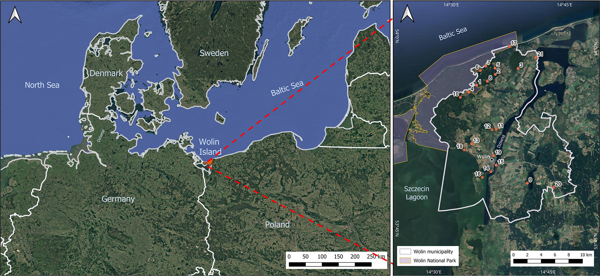
Fig. 1.
Wolin Island location in the southern part of the Baltic Sea; the numbers in the Wolin Municipality indicate the numbers of geosites (see Table 2). (Google Satellite derived from Geoportal 2).
Table 2.
Overview and general characteristics of the assessed geosites.
| Dominant origin | Geosite number | Geosite, coordinates | Brief description |
|---|---|---|---|
| water bodies | 1 | Lake Czajczea N: 53°56'15,180" E: 14°33'25,340" | A post-glacial channel lake with a cryptodepression, hydrologically connected to other lakes of the Wolin lakeland through the Lewińska Struga system. On a peninsula extending into the lake, there are remains of a Slavic stronghold dating back to the 9th–12th centuries. |
| 2 | Lake Kołczewoa N: 53°57'31,980" E: 14°36'21,960" | A post-glacial channel lake with a bottom below sea level, formed within a subglacial channel on Wolin Island. In its vicinity are peat bogs and the remains of a 12th-century Slavic stronghold, highlighting the historical significance of the area. | |
| 3 | Lake Koprowoa N: 53°58'05,700" E: 14°39'24,300" | A lake formed by the isolation of a marine bay, characterised by a muddy bottom and a rich reed belt that constitutes an important bird habitat. It is the largest lake of the Wolin Lakeland and a popular recreational site, with nearby tourist trails for kayaking, hiking, and cycling. | |
| 4 | Lake Rabiąża N: 53°55'34,080" E: 14°33'04,800" | A post-glacial ribbon lake with a cryptodepression, connected to the Lewińska Struga hydrological system. Located within the Wolin National Park, it represents a valuable natural area of tranquil character. | |
| 5 | Lake Reczea N: 53°58'00,600" E: 14°36'21,600" | The deepest lake of the Wolin Lakeland, formed by the melting of dead ice, with a possible meteoritic origin. Its geological structure and isolation emphasise the unique character of this water body. | |
| 6 | Lake wisełkaa N: 53°57'42,800" E: 14°34'20,400" | Formed within a subglacial channel during the Baltic glaciation, the lake is characterised by sandy, gently sloping shores. Surrounded by forests and fields, it is attractive for water recreation and angling. | |
| 7 | Lake zatoreka N: 53°58'07,680" E: 14°35'06,660" | A small channel lake with a bottom below sea level (cryptodepression), surrounded by glacial landforms. Due to its habitat for numerous flora and fauna species, a nature trail with educational infrastructure has been established in its vicinity. | |
| 8 | Lake Żółwińskiea N: 53°56'57,400" E: 14°35'22,500" | The lake fills a post-glacial channel formed during the Vistulian glaciation, with a characteristic meridional arrangement of subglacial troughs. Its morphology reflects the long-term glacial processes of the region. | |
| 9 | Lake Ostrowob N: 53°49'27,300" E: 14°41'58,900" | A shallow channel lake with a maximum depth of just over 6 m, situated on the Gryfice Plain and fed by the Grzybnica River, which also drains its waters into the Kamień Lagoon. Its south-eastern shore borders the Wiejkowski Las nature reserve. | |
| 10 | Łuniewo Reserve,a N: 53°55'33,900" E: 14°32'09,800" | An area comprising raised bogs and a dystrophic lake within a dead-ice depression. It is an important site for biodiversity conservation, accessible through educational paths. | |
| accumulation landforms | 11 | Kame Unińskie Hilla N: 53°53'15,500" e: 14°37'00,900" | It is a fluvioglacial kame composed of sands, silts, and gravels resting on glacial till, formed within an ice-crevasse during deglaciation. It constitutes a valuable example of a glacial landform with significant educational potential. |
| 12 | Mokrzyca Peatlandsa N: 53°53'12,240" E: 14°36'25,920" | Represent an extensive area of reed and tree-sedge peat deposits, exceeding 4 m in thickness. They provide an important habitat for wetland bird species and peatland vegetation, although the terrain is relatively inaccessible. | |
| 13 | Mokrzyca Hillsa N: 53°51'59,610" E: 14°33'53,430" | The Mokrzyca Hills form a moraine complex with diverse relief, created during several phases of glaciation. At the summit lie the ruins of the Żurawice Castle, which combine geological values with historical heritage. | |
| 14 | Wiselców Hilla N: 53°49'55,333" E: 14°36'37,598" | Wisielców Hill (eng. “wisielców" – gallows) is an archaeological reserve containing a barrow cemetery from the 9th–11th centuries, situated on an esker composed of gravel-sand deposits. The combination of geological and cultural values makes this site an important educational point. | |
| 15 | Wolińska Isletb (pl. Kępa) N: 53°50'26,900" E: 14°37'12,600" | A small river islet located on the Dziwna Strait. The proposed geosite is primarily of cultural significance due to the presence of an open-air museum of early medieval architecture and the annually organised Festival of Slavs and Vikings. Because of valuable bird habitats, the southern part of the islet has been designated for protection under the Natura 2000 network. | |
| 16 | Rów Peninsulaa N: 53°49'26,220" E: 14°35'33,900" | It is an extensive, low-lying swamp and peatland area of Holocene origin, associated with the transgressions of the Baltic Sea and the development of deltaic fluvial forms of the Szczecin Lagoon. The area is composed mainly of fen peat and fluvio-marine deposits, displaying features of deltaic accumulation and marked lithological diversity. | |
| geological exposures | 17 | Cliff in Świętouśćb N: 53°59'45,800" E: 14°38'00,600" | The cliff in Świętouść represents an example of an active abrasion coast of the southern Baltic Sea, with well-developed landslide processes and distinct exposures of glacial deposits. It is composed mainly of till, fluvioglacial sands, and gravels, reaching a height of up to approximately 15 m. The site is of high documentary and educational value, as well as possessing aesthetic and landscape significance. |
| 18 | Cliff on the Szczecin Lagoon in Sułominoa N: 53°51'29,488" E: 14°32'56,793" | The southern coast of Wolin Island, along the section between Wolin and Sułomino, is characterised by a well-developed cliff form, reaching heights between 5 and 12 m. The cliff is built predominantly of glacial deposits, including fluvioglacial sands and gravels, as well as till originating from the Pomeranian phase of the Vistulian glaciation. | |
| 19 | Srebrne Hilla and Młynówka Hilla N: 53°51'10,519" E: 14°36'52,322" | Srebrne Hill is an esker formed in a subglacial tunnel, approximately 2 km in length, composed of sand and gravel deposits. The site also holds archaeological significance as the location of a former Wolin settlement from the 9th–12th centuries. In the same area, another geosite – Młynówka Hill – is located, with primarily cultural value due to the remains of a burial ground dating from the 10th to the 12th century. | |
| others | 20 | Cretaceous outcrop in Ostromicea N: 53°48'59,580" E: 14°45'02,580" | It is an accumulation of marls and marly limestones within glacial deposits, which have been subject to exploitation. They were transported by the Scandinavian ice sheet and deposited in their present location during the Vistulian glaciation. The marls and oolitic marly limestones are interbedded with tills containing numerous pebbles and cobbles. The coexistence of deposits of different stratigraphic positions provides evidence of the dynamic nature of sedimentary processes. |
| 21 | Oil well in Zastańa N: 53°59'02,200" E: 14°41'38,700" | The oil well of the Kamień Pomorski oil field exploits the Main Dolomite reservoir, characterised by a porous-fractured structure with high permeability. The deposit is the third largest in the Polish Lowlands and contains sulfur, which affects the specificity of extraction. |
In terms of physical geography, the area under study belongs to the Polish Lowlands, within the South baltic lake District province, the Szczecin Coast macroregion, and the Uznam and Wolin, and Trzebiatowskie Coast (Richling et al. 2021) mesoregions. The north-western part of the study area comprises the most geomorphologically diverse sections of Wolin Island, including a terminal moraine plateau and the Baltic cliff coast zone. Outside this area, large parts of the municipality are characterised by morainic uplands and subglacial depressions modified by meltwater processes (Piotrowski, Schiewe 2021). From a geological perspective, the Wolin municipality is dominated by Quaternary deposits, primarily Pleistocene till, glacial sands and gravels, and glaciofluvial sediments formed during the North Polish glaciations, particularly the Vistulian Glaciation. During the Holocene, organic and marine accumulation processes played a significant role, especially within floodplain and valley zones, leading to the development of peatlands, gyttja, and deltaic deposits in the southern part of the municipality, in the vicinity of the Szczecin lagoon and the Dziwna Strait (Piotrowski, Schiewe 2021). The terrain is characterised by significant diversity and the presence of numerous glacial forms. Pleistocene morainic plateau forms dominate here, with a distinct terminal moraine ridge, the accumulative sandy shore ridges of the Świna Gate, as well as Holocene mineral-organic deposits of the Świna>s regressive delta and silts and river deposits related to the Oder’s activity (Richling et al. 2021). Modern morphogenetic processes, mainly the influence of wind and sea, lead to the formation of dunes, wide beaches, and cliffs (Kostrzewski et al. 2021). They are supplemented by the activity of watercourses, associated with the accumulation of river sediments. The diverse terrain, combined with high biodiversity, contributed to the creation of Wolin National Park, which includes the most valuable natural north-western part of the island, located between the Szczecin Lagoon and the Baltic Sea (Najwer et al. 2022). Within the municipality, 18 geosites (Geostanowiska 2025) have been identified, including lakes of the Woliński lake District, glacial moraines, a cliff coast, peat bogs, and sites of special cultural value (Table 2). The landscape and natural values of the Wolin municipality make it a particularly attractive tourist destination (Zwoliński et al. 2024). The geological structure and the main elements of the relief of Wolin Island, with particular emphasis on the Wolin National Park, are discussed in the Geological Guidebook: Wolin National Park and Adjacent Areas (Piotrowski, Schiewe 2024). Besides natural resources, cultural heritage elements are of particular importance, including the Slavs and Vikings Centre and the annual Slavs and Vikings Festival, which is one of the most important historical and cultural events in the region.
Different perspectives on geotourism development
Stakeholders’ perspective
From the perspective of the stakeholders of the Wolin municipality, the most important tourist attractions of the region include landscape values and the richness of natural and cultural resources. The area of the municipality is characterised by a great diversity of landscapes, which makes it an attractive destination for cycling and landscape tourism. Nearly 30 km of bike trails run through the municipality, including parts of the international Velobaltica and GreenVelo trails, which lead around the Szczecin Lagoon, among other places, as one local stakeholder noted, “The tourist attractions and the whole landscape, which is beautiful in the area of the Wolin municipality, can be seen very well and observed because we have almost 30 km of bike paths”. These routes not only enable active recreation but also control tourist traffic to the most interesting points on the map of the municipality. Additionally, the developed offer of mobile applications related to bike trails facilitates planning and exploration of the area. The landscape of the Wolin municipality is shaped by various water forms, which are an important element of its tourist attractiveness. The Dziwna Strait, the Szczecin Lagoon, access to the Baltic Sea, and numerous lakes and wetlands, including the protected Lake Koprowo, are noteworthy. This hydrological diversity makes it possible to observe and experience various types of aquatic environments, which is highly appreciated by visitors. The proximity of the Wolin National Park, which offers valuable natural areas and beaches in the towns of Wisełka and Świętouść, also plays an important role, attracting tourists seeking contact with nature.
In addition to its natural attractions, the Wolin municipality also has a rich offer of cultural and historical attractions. Among them are the Kikut lighthouse near wisełka, the observation tower in Wolin with access to the recreational area in the city park, as well as the seaport in Wolin. As one of the interviewees assesses, “(…) in addition to environmental attractions […], the tourist attractions include a viewing tower”. The Viking Museum, which serves an educational function, is of particular interest. History lessons are conducted there by teachers from local schools. It is also worth mentioning the Viking Festival and the strong historical accent, which is the figure of the Danish king Harald Bluetooth, connected with the past of Wolin. Historic monuments and places of historical significance, such as the collegiate church in Wolin, the regional museum, or the remains of burial mounds, although currently in a poor state, are also part of the local cultural identity. According to one of the interviewees, “[…] the museum is a historical attraction, […] it will be open for the holidays with a new exhibition […], there are tours coming to see the collegiate church […]. The Slavs and Vikings Open-Air Museum, which organises activities for children”. The offer is complemented by holiday resorts such as Wolin and wisełka, as well as the city park in wolin, which was developed with the needs of both inhabitants and visitors in mind.
From the perspective of the stakeholders of the Wolin municipality, the geotourism potential of this area remains largely untapped, and many objects with geomorphological and geological values are not currently adequately promoted or recognised by a wider audience. One of the respondents stated that “[…] they are not promoted because they are not known”. Despite this, the area of the municipality is characterised by a varied relief, which may be the basis for the development of geotourism in the future. The Mokrzyca Hills, as well as the cliff coasts in Świętouść and Sułomino, are particularly notable examples of forms shaped by erosion and accumulation processes in the Baltic Sea coastal area. Within the municipality, there are also numerous lakes, which, in addition to their natural values, can serve as a geoeducational function within geotourism trails, showing, among others, the genesis of glacial terrain forms and their contemporary transformations. Although no sites related to former mining are present, an artificially exposed geological feature, represented by a Cretaceous outcrop, may serve as a basis for geological educational content. Examples of such locations are the area around Ostromice and the gravel quarry near Wolin. Although these places are not currently adapted for tourism purposes, they have the potential to serve an educational function as part of geotourism activities if they are properly developed and marked. As one local stakeholder noted “[…] there is a gravel quarry, I don’t know what its touristic significance would be, […] there are mining remains, but it is private land”.
An analysis of the strengths, weaknesses, opportunities, and threats related to the development of geotourism in the Wolin municipality, conducted on the basis of in-depth interviews with representatives of local authorities, reveals a number of aspects that influence the shaping of the region’s tourism potential. Among the strengths, respondents pointed out the high landscape values, which include the presence of the Szczecin Lagoon, the Dziwna Strait, access to the Baltic Sea, numerous lakes, and the direct vicinity of the Wolin National Park, as confirmed by one of the interviewees: “The strengths are the location, the Szczecin Lagoon on one side, the Dziwna Strait, (…), Baltic Sea, Świętouść, numerous lakes (…). vicinity of Wolin National Park”. The spatial diversity of the municipality, including both island and mainland areas, enhances the area’s attractiveness from the point of view of landscape perception. The developed network of tourist trails, a railway station providing convenient transport connections, and the functioning of tourist infrastructure, such as a viewing tower, are also significant advantages that effectively stimulate tourist traffic. The well equipped campsite in Świętouść and the inter-institutional cooperation initiatives that support the development of tourism in the region (e.g., Blue Velo Bicycle Route) are also noteworthy. On the other hand, there are also many weaknesses that limit the full use of the municipality’s potential in the field of geotourism. Among them, the lack of bathing areas outside the coastal strip, insufficient recognition and marking (on an informative panel/board) of selected geomorphological forms, such as the cliff in Świętouść, and the neglected state of some cultural heritage sites, such as burial mounds or Młynówka Hill, as one local stakeholder noted, “(…) no swimming areas, no access to lakes”. The free access to some attractions, such as the observation tower, also remains problematic, which limits the possibilities of generating funds for maintenance and promotion. Additionally, the local museum is currently closed, and the promotion of geotourism attractions is considered insufficient by the respondents. Geological formations, such as the oil well in Zastań or the Cretaceous outcrop in Ostromice, are not well-exposed, and most lakes are difficult to access due to the lack of developed infrastructure. In the words of one interviewee “We don’t have many places to stay, but those that are available are popular and crowded. People like staying there and it is a great base for exploring the area” confirms that the municipality also faces the problem of limited accommodation and the dominance of day trippers, which limits potential income from the tourism sector. Wolin remains in the shadow of more recognisable centres, such as Międzyzdroje or the Woliński National Park itself, which also affects the lower recognition of the municipality’s tourist offer. Among the identified development opportunities, attention was drawn to the possibility of developing the area of the sea harbour in Wolin, where a bathing area and a viewpoint are planned to be created. In combination with the city park, the observation tower, and the nearby beach, an alternative form of recreation could be created for tourists seeking quieter places than the crowded seaside resorts. In the immediate vicinity of these objects, there are also burial mounds, which can complement the cultural, historical, and geological offer. Another opportunity is the planned archaeological activities (related to research on the Harald Bluetooth runestone), which could be carried out in cooperation with partners from Denmark. There is also a possibility of developing an educational offer, among others, through field games aimed at young people, and further investment in tourist infrastructure, an example of which is the already completed construction of a viewing tower. The potential of creating a local historical trail was also pointed out, as well as the growing interest in the region among various groups of tourists, not only history enthusiasts, but also people looking for attractive landscapes. The interviewees admitted that they “(…) focus on history and have historical objects that we want to mark (…), a trail related to these objects (…), and then natural objects”. There is also a chance for the development of water tourism, including attractive trips by water trams between islands on the Szczecin Lagoon, along the dead cliff, and through the Dziwna Strait, which was noted by one of the stakeholders: “Water tourism could be the best tool to see things that you can’t reach”. The threats to the development of geotourism include the dominant educational role of the Woliński National Park, which may limit the competitiveness of the offer of the Wolin municipality. Despite the implementation of international projects, such as digital visualisation of monuments and figures related to the city’s history, there is a risk that the promotion of selected forms of terrain sculpture, for example, the cliff in Sułomino, will remain insufficient due to the difficulty of accessing these locations.
From the perspective of the local authorities of the Wolin municipality, geotourism remains a still underdeveloped, yet promising segment of the region’s tourist offer. This area is characterised by significant geomorphological and landscape diversity, including varied cliff coasts in Świętouść and Sułomino, the hills of Mokrzyca Hills, as well as numerous glacial (e.g., Lake Wisełka) and coastal lakes (Lake Koprowo). These natural values provide a natural basis for the development of geotourism trails and forms of cognitive tourism focused on geological and geomorphological phenomena. At the same time, a number of barriers are pointed out that hinder the development of this type of tourism. Among them, the insufficient promotion and lack of marking of significant geological forms, such as the cliff in Świętouść or the oil well in Zastań, are mentioned above all. Potentially interesting geological sites, such as the Cretaceous outcrop in Ostromice or north of the city of Wolin, are also not adapted for tourism. There is a lack of infrastructure that would enable safe and convenient visits to such places, as well as interpretive activities that could make them more accessible to tourists. In the context of development opportunities, the possibility of developing the area of the sea harbour in Wolin was emphasised, where investments in a bathing area and a viewpoint are planned. In combination with the observation tower, the city park, and the neighbouring burial mounds, this area can become a local centre of landscape geotourism. Attention was also drawn to the need to consider the establishment of new geosites, which, in the opinion of the representatives of the municipality, have high geotourism potential. Among them are the beach in Wisełka, Lake Ostrowo in Wiejkowo, the spring between Dargobądz and Mokrzyca, and the Dziwna Strait as an area of exceptional hydrological and geomorphological dynamics. The hilly areas around Płocin and cultural heritage elements with landscape connections, such as the Viking Museum and the archaeological reserve in Wolin, may also be of interest, as they can serve as a starting point for a narrative about the transformation of the geographical environment in a historical context. An example of such activity may be the offer of geowalks tour with experts or geowatching (Garofano 2015).
Additional development opportunities are seen in the use of funds from international projects, the development of educational forms of transmission (e.g., field games), and the integration of geotourism with existing tourist trails. The threats included the competitiveness of the educational offer of the Wolin National Park, whose activities may overshadow local initiatives. Attention was also drawn to the poor accessibility of some terrain forms, such as the cliff in Sułomino, which may result in their low recognition despite their high cognitive value. As a result of the discussions, it was recognised that geotourism in the Wolin municipality has significant, yet untapped potential, the development of which requires coordinated actions in the areas of infrastructure, promotion, education, and interpretation of geological heritage.
The in-depth interview was supplemented by a survey of seventeen employees of the City and Municipality Office in Wolin, which assessed their knowledge of and interest in individual geosites. The average value of all evaluated geosites was 2.48, while the geotourism attractiveness rating was significantly higher for the Lake Wisełka geosite , followed by Lake Żółwińskie , the Wisielców Hill , and the cliff on the Szczecin Lagoon in Sułomino . The lowest rated, and at the same time least known geological sites include Lake Recze , oil well in Zastań , cretaceous outcrop in Ostromice , Lake Zatorek , and the Łuniewo reserve .
Social assessment of geosites
In the opinion of the inhabitants of the Wolin municipality, the most important tourist attractions of the region can be classified into several main categories, which directly or indirectly highlight the geodiverse character of local tourism assets. Natural features were most frequently indicated, such as lakes (e.g., Lake Warnowo), the viewpoint in Lubin, the Wisielców Hill, and Wolin National Park. Beaches and coastal areas also form a significant category, including the beach in Wisełka and the wild beach in Wolin. Cultural heritage was considered equally important, particularly the Slavs and Vikings Village and the annually organised Slavs and Vikings Festival. The observation tower and the municipal park in Wolin were also identified as notable elements of recreational infrastructure. Respondents further mentioned more niche attractions, such as the lavender plantation in Kodrąbek and the Kikut lighthouse in Wisełka.
In terms of the attractiveness of individual areas of the municipality (Table 3), the highest rated landscape types in the area of Wolin municipality were the coastal zone of the Baltic Sea , areas located along the Szczecin Lagoon , and lake landscapes . The lowest average values were obtained for agricultural landscapes and morain hill areas in the Mokrzyca Wielka region . The relatively low standard deviation and weighted variance for the highest rated landscapes (Table 3) are also noteworthy, indicating a high degree of consistency in the respondents’ ratings. The results suggest that the three most highly rated types of landscape are perceived by inhabitants as the most attractive in terms of geotourism potential.
Table 3.
Perceived attractiveness of selected landscapes in the Wolin Municipality from the perspective of inhabitants (1 – very high, 2 – high, 3 – moderate, 4 – low, 5 – very low, – weighted mean, s2w – weighted variance, sw – standard deviation).
| Selected landscapes in Wolin municipality | Percentage of responses [%] | s2w | sw | |||||
|---|---|---|---|---|---|---|---|---|
| 1 | 2 | 3 | 4 | 5 | ||||
| Baltic Sea coast | 70.5 | 20.5 | 9.1 | – | – | 4.57 | 0.42 | 0.65 |
| Areas along the Szczecin Lagoon | 54.5 | 25.0 | 15.9 | 4.5 | – | 4.48 | 0.61 | 0.78 |
| Lakes | 50.0 | 22.7 | 15.9 | 11.4 | – | 4.30 | 0.80 | 0.89 |
| Area adjacent to Wolin National Park | 63.6 | 22.7 | 11.4 | 2.3 | – | 4.11 | 1.10 | 1.05 |
| Areas along the Dziwna Strait | 36.4 | 29.5 | 27.3 | 4.5 | 2.3 | 3.93 | 1.02 | 1.01 |
| The town of Wolin | 11.4 | 18.2 | 36.4 | 27.3 | 6.8 | 3.45 | 1.43 | 1.20 |
| Hills near Mokrzyca Wielka | 22.7 | 27.3 | 31.8 | 9.1 | 9.1 | 3.11 | 1.33 | 1.15 |
| Agricultural areas | 11.4 | 31.8 | 20.5 | 29.5 | 6.8 | 3.00 | 1.18 | 1.09 |
It is worth noting that in the case of the Baltic coast, as many as 70.5% of respondents gave the maximum rating (1), and the total share of ratings was 91%. Similarly, high values were recorded for areas near the Szczecin Lagoon (79.5%) and lakes (72.7%). A high percentage of positive ratings, combined with a low weighted variance value (0.42; 0.61; 0.80, Table 2), confirms the consistency of the inhabitants’ perception of the attractiveness of these areas. In comparison, only 11.4% of respondents rated agricultural land the highest (rating 1), and their weighted average was 3.00 – the lowest among the analysed categories. Higher values of variance and standard deviations (1.18 and 1.09, respectively) indicate a greater diversity of opinions.
In the context of assessing the attractiveness of geosites (evaluated geosites from the Central Geological Database Portal – Geostanowiska 2025) in the area of the Wolin municipality, the weighted average for all the indicated locations was 3.5 (Table 4). Among the analysed locations, lake Wisełka (; Table 4) and the cliff above the Szczecin Lagoon stood out, achieving the highest values. Relatively high ratings were also given to Lake Kołczewo , Lake Czajcze , as well as Lake Żółwińskie and the Wisielców Hill . On the other hand, the lowest level of attractiveness, according to the respondents, was characterised by geosites: an oil well in Zastań and a Cretaceous outcrop in Ostromice . The relatively low values of weighted variance and standard deviation for the best-rated locations (Table 4) indicate the consistency of the respondents’ perceptions. Therefore, the results allow Lake wisełka, the cliff above the Szczecin Lagoon, and Lake Kołczewo to be considered by inhabitants to be the most attractive geosites.
Table 4.
Attractiveness of Polish Geological Institute – national Research Institute geosites (Geostanowiska 2025) in the wolin Municipality from the perspective of inhabitants (1 – very high, 2 – high, 3 – moderate, 4 – low, 5 – very low, – weighted mean, s2w – weighted variance, sw – standard deviation).
| Geosites | Percentage of responses [%] | s2w | sw | ||||||
|---|---|---|---|---|---|---|---|---|---|
| 1 | 2 | 3 | 4 | 5 | |||||
| 6 | wisełka lake | 68.2 | 22.7 | 6.8 | 2.3 | 0.0 | 4.57 | 0.52 | 0.72 |
| 18 | cliff on the Szczecin lagoon in Sułomino | 27.3 | 40.9 | 18.2 | 4.5 | 9.1 | 4.29 | 0.89 | 0.94 |
| 2 | Kołczewo lake | 34.1 | 38.6 | 13.6 | 4.5 | 9.1 | 3.91 | 0.81 | 0.90 |
| 1 | Czajcze Lake | 15.9 | 38.6 | 27.3 | 9.1 | 9.1 | 3.84 | 1.45 | 1.21 |
| 8 | Żółwińskie lake | 20.5 | 38.6 | 18.2 | 9.1 | 13.6 | 3.73 | 1.38 | 1.18 |
| 14 | wisielców Hill | 13.6 | 38.6 | 22.7 | 11.4 | 13.6 | 3.71 | 1.57 | 1.25 |
| 11 | Kame Uniński Hill | 25.0 | 52.3 | 11.4 | 11.4 | 0.0 | 3.57 | 1.89 | 1.38 |
| 3 | Koprowo Lake | 18.2 | 43.2 | 22.7 | 4.5 | 11.4 | 3.52 | 1.39 | 1.18 |
| 16 | Rów Peninsula | 11.4 | 34.1 | 25.0 | 13.6 | 15.9 | 3.52 | 1.43 | 1.20 |
| 19 | Srebrne Hill and Młynówka Hill | 11.4 | 36.4 | 22.7 | 13.6 | 15.9 | 3.46 | 1.61 | 1.27 |
| 4 | Rabiąż lake | 11.4 | 34.1 | 22.7 | 15.9 | 15.9 | 3.43 | 1.29 | 1.14 |
| 7 | zatorek lake | 52.3 | 34.1 | 6.8 | 4.5 | 2.3 | 3.43 | 1.65 | 1.29 |
| 5 | Recze Lake | 22.7 | 34.1 | 20.5 | 11.4 | 11.4 | 3.27 | 1.52 | 1.23 |
| 10 | Łuniewo Reserve | 29.5 | 38.6 | 15.9 | 4.5 | 11.4 | 3.14 | 1.57 | 1.25 |
| 12 | Mokrzyca Peatlands | 22.7 | 34.1 | 25.0 | 9.1 | 9.1 | 3.11 | 1.56 | 1.25 |
| 13 | Mokrzyca Hills | 13.6 | 38.6 | 13.6 | 18.2 | 15.9 | 3.09 | 1.58 | 1.26 |
| 20 | Creaceous outcrop in Ostromice | 9.1 | 27.3 | 22.7 | 20.5 | 20.5 | 2.84 | 1.63 | 1.28 |
| 21 | oil well in zastań | 4.5 | 25.0 | 25.0 | 18.2 | 27.3 | 2.61 | 1.56 | 1.25 |
It is worth noting the relatively low standard deviation and weighted variance values for the best-rated geosites. The highest perception agreement was observed in the case of Lake Wisełka (sw = 0.72; s2w = 0.52; Table 4), which may indicate a well-established and unequivocally positive opinion of the inhabitants about its attractiveness. The opposite trend was observed for locations such as Srebrne Hill (s2w = 1.61 or Kame Uniński Hill (s2w = 1.89), where, despite moderate average ratings ( and 3.57, respectively), the level of dispersion of responses was significantly higher, suggesting a lack of uniform assessment of their attractiveness among respondents. Even in the case of the lowest-rated geosites, the oil well in Zastań and the Cretaceous outcrop in Ostromice , the values of sw remain relatively high (1.25 and 1.28, respectively), which may indicate an ambiguous perception of their significance from the point of view of geotourism. Such data may suggest the need for better exposure or interpretation (e.g. through infrastructure or geotourism narrative) to increase their recognition and cognitive value.
The inhabitants of the Wolin municipality perceive geotourism as an important, yet so far untapped, development potential of the region. Their statements are dominated by positive references to unique natural and landscape values, such as extensive green areas, low level of urbanization and varied terrain in the vicinity of the sea and the Szczecin Lagoon. These advantages create favourable conditions for the development of educational tourism, including that focused on the geological and geomorphological heritage of the area. At the same time, respondents point to a number of barriers that currently limit the development of geotourism. The most frequently mentioned issues include: lack of marked trails and information infrastructure, insufficient promotion of local geological forms, and a lack of coordination efforts on the part of local authorities.
Scientific assessment of geosites
The expert evaluation of 21 geosites included both 18 sites listed by the Polish Geological Institute – National Research Institute (Geostanowiska 2025) and those identified as the most attractive, through social research (Wolińska Islet, Lake Ostrowo, cliff in Świętouść). The assessment of geosites for the purpose of geotourism development in the municipality of Wolin was based on determining their significance in terms of scientific value, additional value and utility features (Table 5). The application of the aforementioned evaluation methodology (Kubalíková 2019) allowed for determining the average value of geosite assessment at 0.59. A total of 10 geosites received a general assessment of greater than or equal to 0.59, among which are sites belonging to three of the four described categories (water bodies, accumulation landforms, geological exposures) (Fig. 2). The highest assessment was given to Wolińska Islet (0.88). The high assessment of this geosite is primarily due to its unique cultural, tourist, natural, and educational values. wolińska Islet is a river islet on which the Slavs and Vikings Centre open-air museum is located, and where a festival is organised every year. In addition, the southern part of the island is covered by the Natura 2000 special protection area for birds. The Łuniewo Reserve was highly assessed (0.78) primarily due to its scientific values. The reserve includes a dystrophic lake of the same name and the surrounding transitional and high peat bog. The area is a habitat for many bird species and a place where valuable plant communities occur. There is an educational trail here. In the general classification, the cliff in Świętouść (0.77) was in third place, which, in addition to its high scientific values, is also distinguished by its significant aesthetic values. Among the 10 highest-rated geosites were also Lake Wisełka (0.74), Rów Peninsula (0.72), Kołczewo (0.68), and Koprowo (0.67) lakes, the wisielców Hill and the cliff on the Szczecin lagoon in Sułomino (0.66 each), and closing the top ten was Lake Czajcze (0.64). These are objects characterised by very high scientific values (average 0.8) and significant added values (0.75), while their utility features were assessed significantly lower (0.6).
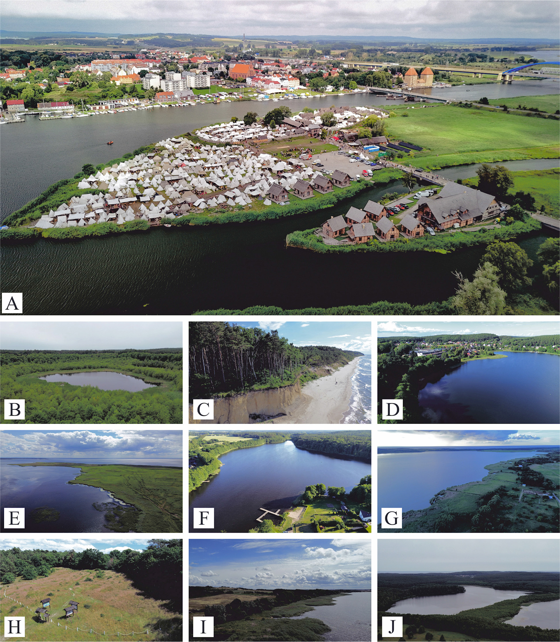
Fig. 2.
Top 10 geosites ranked by expert assessment. A – Wolińska Islet, B – Łuniewo Reserve, C – Cliff in Świętouść, D – lake Wisełka, E – Rów Peninsula, F – lake Kołczewo, G – lake Koprowo, H – Wisielców Hill, I – Cliff on the Szczecin lagoon in Sułomino, J – lake Czajcze.
Source: A: J. niewinczany – wolin City Hall. b–J: own photographs.
Table 5.
Geosites assessment (I – accumulation landforms, II – water bodies, III – geological exposures, IV – others).
| Geosite type | Geosite | Geosite number | Integrity | Representativeness | Rareness | Paleogeographical interest | Total scientific values | Ecological | Aesthetical | Cultural | Total added values | Protection status | Threats | Accessibility | Security | Site context | Tourist infrastructure | Interpretive facilities | Educational interest | Total use characteristics | Geosite score |
|---|---|---|---|---|---|---|---|---|---|---|---|---|---|---|---|---|---|---|---|---|---|
| II | Wolińska Islet | 15 | 0.5 | 1 | 1 | 1 | 0.88 | 0.75 | 0.75 | 1 | 0.83 | 1 | 0.75 | 0.75 | 1 | 1 | 1 | 1 | 1 | 0.94 | 0.88 |
| I | Łuniewo Reserve | 10 | 1 | 1 | 1 | 1 | 1.00 | 1 | 0.75 | 0.25 | 0.67 | 1 | 1 | 0.5 | 0.5 | 0.5 | 0.5 | 0.75 | 0.75 | 0.69 | 0.78 |
| III | Cliff in Świętouść | 17 | 0.75 | 1 | 1 | 1 | 0.94 | 0.75 | 1 | 0.5 | 0.75 | 1 | 0.5 | 0.5 | 1 | 0.5 | 0.5 | 0 | 1 | 0.63 | 0.77 |
| I | Lake Wisełka | 6 | 1 | 1 | 0.5 | 0.5 | 0.75 | 0.75 | 1 | 0.5 | 0.75 | 1 | 0.75 | 0.75 | 0.75 | 0.75 | 0.75 | 0.5 | 0.5 | 0.72 | 0.74 |
| II | Rów Peninsula | 16 | 1 | 1 | 1 | 0.5 | 0.88 | 1 | 1 | 0.5 | 0.83 | 1 | 0.75 | 0.25 | 0.5 | 0.25 | 0 | 0 | 0.75 | 0.44 | 0.72 |
| I | Lake Kołczewo | 2 | 1 | 1 | 1 | 0.25 | 0.81 | 0.5 | 0.75 | 0.75 | 0.67 | 0.75 | 0.5 | 0.75 | 0.75 | 0.75 | 0.5 | 0 | 0.5 | 0.56 | 0.68 |
| I | Lake Koprowo | 3 | 1 | 1 | 0.5 | 0.5 | 0.75 | 0.75 | 1 | 0.5 | 0.75 | 0.75 | 0.5 | 0.75 | 0.75 | 0.5 | 0.25 | 0 | 0.5 | 0.50 | 0.67 |
| II | Wisielców Hill | 14 | 1 | 0.75 | 0.25 | 0.5 | 0.63 | 0.75 | 0.75 | 1 | 0.83 | 0.25 | 0.5 | 0.5 | 0.75 | 0.5 | 0.75 | 0.5 | 0.5 | 0.53 | 0.66 |
| III | Cliff on the Szczecin Lagoon in Sułomino | 18 | 0.75 | 1 | 0.25 | 1 | 0.75 | 0.75 | 1 | 0.5 | 0.75 | 0.75 | 0.5 | 0.25 | 0.25 | 1 | 0.25 | 0 | 0.75 | 0.47 | 0.66 |
| I | Lake Czajcze | 1 | 1 | 1 | 0.5 | 0.25 | 0.69 | 0.5 | 0.75 | 0.75 | 0.67 | 0.75 | 0.75 | 0.5 | 0.75 | 0.75 | 0.25 | 0.25 | 0.5 | 0.56 | 0.64 |
| I | Lake Zatorek | 7 | 1 | 1 | 0.5 | 0.5 | 0.75 | 0.5 | 0.75 | 0.25 | 0.50 | 0.5 | 0.5 | 0.5 | 0.5 | 0.5 | 0.5 | 0.5 | 0.5 | 0.50 | 0.58 |
| II | Mokrzyca Peatland | 12 | 0.75 | 0.5 | 0.5 | 1 | 0.69 | 1 | 0.5 | 0.25 | 0.58 | 0.75 | 0.5 | 0.25 | 0.25 | 0.5 | 0.25 | 0 | 0.75 | 0.41 | 0.56 |
| II | Mokrzyca Hills | 13 | 1 | 0.75 | 0.25 | 0.5 | 0.63 | 0.5 | 0.5 | 0.5 | 0.50 | 0.5 | 0.5 | 0.5 | 0.75 | 0.75 | 0.25 | 0 | 0.5 | 0.47 | 0.53 |
| I | lake Rabiąż | 4 | 1 | 1 | 0.5 | 0.25 | 0.69 | 0.5 | 0.5 | 0.25 | 0.42 | 0.75 | 0.75 | 0.5 | 0.5 | 0.5 | 0.25 | 0 | 0.25 | 0.44 | 0.51 |
| I | Lake Żółwińskie | 8 | 1 | 1 | 0.5 | 0.25 | 0.69 | 0.5 | 0.5 | 0.25 | 0.42 | 0.75 | 0.75 | 0.5 | 0.5 | 0.25 | 0 | 0 | 0.25 | 0.38 | 0.49 |
| IV | Oil well in zastań | 21 | 1 | 1 | 0.5 | 0.75 | 0.81 | 0 | 0 | 0.75 | 0.25 | 0 | 0.75 | 0.5 | 0.75 | 0.25 | 0 | 0 | 0.75 | 0.38 | 0.48 |
| I | Lake Recze | 5 | 1 | 1 | 0.5 | 0.5 | 0.75 | 0.25 | 0.5 | 0.25 | 0.33 | 0.5 | 0.5 | 0.5 | 0.5 | 0.25 | 0 | 0 | 0.25 | 0.31 | 0.47 |
| I | Lake Ostrowo | 9 | 1 | 1 | 0.5 | 0.25 | 0.69 | 0.25 | 0.5 | 0 | 0.25 | 0.75 | 0.75 | 0.5 | 0.5 | 0.25 | 0.25 | 0 | 0.25 | 0.41 | 0.45 |
| III | Creaceous outcrop in Ostromice | 20 | 0.5 | 0.5 | 0.75 | 1 | 0.69 | 0.25 | 0.25 | 0.5 | 0.33 | 0 | 0.25 | 0.25 | 0.5 | 0.25 | 0 | 0 | 0.75 | 0.25 | 0.42 |
| III | Kame Uniński Hill | 11 | 0.75 | 0.5 | 0.25 | 0.75 | 0.56 | 0.25 | 0.5 | 0.25 | 0.33 | 0 | 0.25 | 0.25 | 0.5 | 0.75 | 0.25 | 0 | 0.5 | 0.31 | 0.40 |
| III | Srebrne Hill and Młynówka Hill | 19 | 0.25 | 0.5 | 0.5 | 0.25 | 0.38 | 0.25 | 0.5 | 0.5 | 0.42 | 0.25 | 0.5 | 0.25 | 0.5 | 0.75 | 0.25 | 0 | 0.25 | 0.34 | 0.38 |
| ∑ | 0.87 | 0.88 | 0.58 | 0.60 | 0.73 | 0.56 | 0.65 | 0.48 | 0.56 | 0.62 | 0.60 | 0.48 | 0.61 | 0.55 | 0.32 | 0.17 | 0.56 | 0.49 | 0.59 |
The ranking of the geosites listed in the table (Table 5) is closed by Srebrne Hill and Młynówka Hill with an average rating of 0.38, which is mainly due to the lack of tourist development, poor exposure of cultural values, and low scientific value.
The average scientific value rating of the described geological sites is 0.73. The highest rating in this category was given to the Łuniewo Reserve (1.00), followed by the cliff in Świętouść (0.94), Wolińska Islet and Rów Peninsula (0.88 each), while the lowest rating was given to Srebrne Hill and Młynówka Hill (0.38). Lower-than-average values were determined for the rareness of geosites (0.58) and palaeogeographical interest (0.60), which is primarily due to the widespread
occurrence of lake forms in this area. In the case of additional values, the average rating of geosites is 0.56, and the highest values concern the geosites Wolińska Islet, Rów Peninsula, and Wisielców Hill (0.83). In this criterion, the lowest value was achieved by the oil well in Zastań (0.25). In this context, the highest average value was determined in the aesthetic criteria, where the cliff in Świętouść, Lake wisełka, Rów Peninsula, Lake Koprowo, and the cliff on the Szczecin Lagoon in Sułomino received a rating of 1.00.
The average value for the criterion use characteristics is 0.49. Wolińska Islet (0.94) stands out with a distinctly higher rating, but Lake Wisełka (0.72), Łuniewo Reserve (0.69), and the cliff in Świętouść are also highly rated. This criterion ranks the Cretaceous outcrop in Ostromice (0.25) and Lake Recze and Kame Uniński Hill (0.31) as definitely low. The protection status, the level of developed tourist infrastructure (especially hiking trails, catering and accommodation facilities) and educational significance (especially the presence of educational trails and boards, educational use of geosites) have a significant impact on the assessment of the site’s utility features. For many geosites, the lack of interpretive facilities has been noted. The assessment carried out made it possible to determine the degree of adaptability of individual geosites for the development of geotourism and constitutes the basis for further analysis.
Discussion
Social and expert assessment
The analysis of results indicates that, from the perspective of Wolin municipality inhabitants, the highest value is assigned to water-related landscapes, in particular the Baltic Sea coastline, the Szczecin Lagoon, and inland lakes. This preference is reflected in the high mean evaluation scores and relatively low variability of opinions. This preference can be explained by the fact that water-related landscapes are widely perceived as natural, distinctive, and emotionally engaging environments, whose visual qualities and symbolic associations are easily recognised and appreciated by both inhabitants and visitors, while individual experience and familiarity further strengthen their perceived attractiveness (Faggi et al. 2013, Arnberger et al. 2023). High attractiveness is also attributed to the areas adjacent to Wolin National Park, underlining the significant role of natural assets in shaping landscape perception within the local community (Żyto 2020). In contrast, the town of Wolin, agricultural areas, and the uplands near Mokrzyca Wielka received lower evaluations, which may be linked to their everyday, utilitarian character or limited exposure of scenic values. A similar trend is observed in the assessment of geosites: the highest ratings were given to Lake Wisełka and the cliff on the Szczecin Lagoon in Sułomino, whereas sites of explicitly geological or anthropogenic character, such as the Cretaceous outcrop in Ostromice or the oil well in Zastań, were ranked lowest. These results demonstrate that the local community primarily associates geotourism attractiveness with aquatic and coastal landscapes (which ensure tourist/recreational appeal), while scientific and educational values require additional interpretation and targeted promotional efforts in order to be fully appreciated.
The expert assessment of geosites in the Wolin municipality provides a broader interpretation of the results obtained from the social perspective. High scientific values were attributed to sites such as the Łuniewo Reserve and Lake Wisełka, which stand out due to their integrity, representativeness, and paleogeographic significance. At the same time, the expert analysis highlights additional sites of high rarity and unique ecological, aesthetic, or cultural value, such as Wolińska Islet and the cliff in Świętouście, which have not yet been recognised by the Polish Geological Institute – National Research Institute (Geostanowiska 2025). The juxtaposition of expert results with the perceptions of the local community reveals substantial differences in the understanding of geotourism attractiveness: while inhabitants predominantly emphasised scenic and recreational values, the expert evaluation incorporated scientific, protective, and educational criteria. These findings underline the necessity of integrating both perspectives when designing local geotourism trails both in terms of site selection and the development of educational and interpretive infrastructure. Comparable approaches have been applied in other regions with similar geotourism potential (e.g., Allan 2016, Deng, Zou 2021). Moreover, the inclusion of newly identified geosites in expert analyses allows for the identification of areas with high geotourism potential that have not yet been fully utilized, such as wolińska Islet and the cliff in Świętouść. The diversity of assessment criteria also demonstrates that geotourism attractiveness does not always correlate with scientific significance, certain sites of exceptional geological value require additional promotion and interpretive measures to be appreciated by both the local community and visitors. Consequently, the comparison of expert and social assessments emphasizes the need for strategic planning of geotourism development in the Wolin municipality, taking into account scientific and natural values alongside community expectations, which may enhance the effectiveness of educational, recreational, and conservation initiatives. The last task should be the responsibility of the municipality.
Geopark and strategic management
An example of such strategic planning and management may be the systematic development of tourist infrastructure around ten selected geosites, which would enable the creation of a coherent and attractive municipal geotourism trail. Such a trail, composed of the geosites identified in this study, could integrate features of high scientific, ecological, landscape, and cultural value with geointerpretive points, while simultaneously ensuring accessibility and visitor safety. It should be further enriched with field workshops organised in the vicinity of the cliff in Świętouść, the Dziwna Strait, and areas along the Szczecin Lagoon, encompassing geomorphological observations, the identification of sediments and glacial landforms, as well as elements of cultural and natural heritage. As emphasised by Štrba et al. (2025), a geotourism trail or individual interpretive elements cannot be regarded as a fully-fledged geotourism product but rather as components of a broader experience that should integrate services, interpretation, and visitor engagement. From this perspective, the planned geotourism trail in the Wolin municipality should be embedded within a comprehensive product in order to fully realise its potential. Similar solutions aimed at developing geotourism offers have been proposed in regions such as, e.g., Montana State (Jorgenson, Nickerson 2015), Salamanca in Spain (Martínez-Graña et al. 2016), the Flinders Ranges World Heritage Nomination area in Australia (Lewis 2020), and the UNESCO Global Geopark Volcanes de Calatrava (Guevara et al. 2025). Complementary initiatives functioning alongside the trail could include the dissemination of interactive tools such as multimedia guides, mobile applications, and outdoor queststyle games, which may enhance visitor engagement and strengthen the educational value of the trail. Support from local institutions, including coordination by the municipal authorities, could facilitate the integration of the trail with existing tourist attractions and economic entities, such as the open-air museum in Wolin or the annual Festival of Slavs and Vikings, which recall the fascinating history of early settlement in the region (Filipowiak 2020). Furthermore, such initiatives foster the multifaceted use of geosites, contributing to the development of sustainable tourism, increasing awareness of geodiversity among inhabitants and visitors, and promoting the region as an educational and recreational destination. Strategic planning of the trail, encompassing both the location of geosites and the design of educational, interpretive, and recreational infrastructure, represents a key element of geotourism development and may serve as a foundation for further research on the establishment of a geopark covering the entire Wolin Island (Winowski, Samołyk 2017, Zwoliński et al. 2024).
However, the establishment of a UNESCO Global Geopark encompassing the entire Wolin Island requires a strategic management plan that integrates geological, landscape, and cultural resources across different administrative levels, with the active involvement of the Wolin municipality (representatives, inhabitants, NGOs). The first step should involve the designation of a network of key geosites across the island, including areas of high scientific value, rare geological formations, and sites of outstanding landscape and cultural significance, such as the cliff in Świętouść, the Dziwna Strait, the Szczecin Lagoon, the Wolińska Islet, and the Wisielców Hill. The implementation plan should encompass the development of educational and interpretive infrastructure, the creation of a geotourism trail, as well as the organisation of field workshops focused on geomorphology, paleogeography, biology, coordinated by local authorities in collaboration with scientific institutions. In this context, the functioning of a future geopark could be further strengthened by the unique cultural heritage of Slavic and Viking settlements on Wolin Island, which provides a valuable foundation for the development of integrated geo-cultural narratives. The combination of geological heritage with archaeological sites, historical landscapes, and legend-based storytelling may enhance visitor engagement and place branding, thereby increasing the overall attractiveness and interpretive potential of the geopark (Halewood, Hannam 2001). In this sense, the geotourism values of the Wolin municipality appear to have significant potential to stimulate geotourism development and, in the long term, to underpin the establishment of a geopark of exceptional importance in the context of Central Europe.
Conclusions
The research demonstrates that inhabitants of the Wolin municipality assign the highest value to aquatic and coastal landscapes, including the Baltic Sea shoreline, the Szczecin Lagoon, and local lakes, highlighting the importance of recreational and landscape values in shaping what they understand to be the geotourism attractiveness of the region. The expert assessment of geosites additionally emphasizes their significant scientific, palaeogeographical, and cultural values, notably the Łuniewo Reserve, the Wolińska Islet, and the cliff in Świętouście, which represent assets with strong potential for geotourism development. The island character of the municipality, its location along the Baltic coast, and its proximity to Wolin National Park provide robust foundations for designing a geotourism trail, while the Viking cultural heritage further reinforces the island’s identity and recognisability. The integration of local geosites with educational infrastructure, field-based workshops, and interactive learning tools can enhance both the touristic appeal of the area and public awareness of geodiversity among inhabitants and visitors. Effective implementation of the geotourism trail should be embedded within a broader regional promotion strategy, incorporating community participation, collaboration with scientific institutions and Wolin National Park, as well as targeted investments in field infrastructure. In the longer term, such measures could establish the basis for the designation of a UNESCO Global Geopark on Wolin Island, integrating scientific, landscape, and cultural values while supporting the sustainable development of tourism in the region.
Acknowledgements
We extend our gratitude to the representatives of the Wolin Municipality, in particular Deputy Mayor Ms. Ewa Deląg and Mayor Ms. Ewa Grzybowska, for their cooperation, assistance in conducting the pilot survey and in-depth interview, as well as for providing photographs of the wolińska Islet. We sincerely thank the reviewers for their insightful and constructive comments, which have significantly contributed to improving the quality of this manuscript.
Notes
[3] Contributed by Authors’ contribution
DA: Conceptualisation, Data curation, Formal analysis, Investigation, Methodology, Resources, Software, Supervision, Validation, Visualisation, Writing – original draft, Writing – review & editing. RT: Data curation, Formal analysis, Investigation, Methodology, Resources, Software, Validation, Visualisation, Writing – original draft, Writing – review & editing.