
Lakes are significant surface water ecosystems that play an essential role in preserving biodiversity, carbon storage, water balance and recreation (Fluet-Chouinard et al. 2017). These water bodies serve as sensitive markers of climate change and anthropogenic pressure (Adrian et al. 2009), with research indicating that around 53% of the world’s largest lakes have declined significantly in recent decades (Yao et al. 2023). A growing number of studies provide evidence of significant and sustained declines in lake water levels worldwide (Fathian, Vaheddoost 2021, Soria, Apostolova 2022, Jiang et al. 2024), emphasising the global nature of this issue. The spatial and temporal variability of lake water level changes was also found in Poland, with statistically significant decreasing long-term trends observed in several lakes (Wrzesiński, Ptak 2016, Choiński et al. 2020, Sojka et al. 2022).
Changes in lake water levels are controlled by a combination of natural and anthropogenic factors (Wu et al. 2021), including climate change, which is a significant driver of multidecadal lake level declines in various regions (Adrian et al. 2009, Woolway et al. 2020, Sojka et al. 2022, Paule-Mercado et al. 2024, Timoney 2024). These changes are caused by an increase in evaporation and air temperature, and a decrease in precipitation or runoff (Schulz et al. 2020, Timoney 2024). In addition, fluctuations in the groundwater level can affect the lake recharge (Paule-Mercado et al. 2024). Furthermore, excessive groundwater abstraction, leading to the lowering of groundwater levels and thus to the depletion of lake recharge, has been identified as a significant contributor to lake water level decline (Chaudhari et al. 2018, Schulz et al. 2020). Given the importance of groundwater in recharging lakes, it is essential to investigate the relationship between these elements thoroughly to manage the region’s water resources effectively and prevent potential lake water level declines.
Lakes are an integral part of the groundwater flow system. In the regional flow system (Fetter 1994), it is a general expectation that topographical elevations (upland regions) contribute to a lake recharge, whilst topographic lows (e.g. regional river valleys) act as a lake water discharge area. However, in local flow systems, the interaction of lake water and groundwater is more complicated due to fluctuations in surface water and groundwater levels (Winter 1999) or differences in geological structure and groundwater flow conditions.
Studies of lake water/groundwater interactions typically use point hydrodynamic measurements with piezometers or monitoring wells (Kidmose et al. 2011, Rudnick et al. 2015). Field measurements of conservative chemical, isotopic or thermal tracer tests (Rautio, Korkka-Niemi 2015, Keim et al. 2019, Santos Correa et al. 2022) are also commonplace to provide insights into the complex hydrological exchange between surface and groundwater.
The presented study shows the application of a gradient metre (Marciniak, Chudziak 2015) to determine the vertical hydraulic gradient (VHG) between the surface water and groundwater in the hyporheic zone, in which a common mixing of surface water and groundwater takes place (Boulton et al. 1998), and steep VHGs are observed (Battin et al. 2003, Smith 2005). The device allows point measurements of the pressure differences between surface water and groundwater in the hyporheic zone, indicating the direction of water filtration through the lake bottom sediments. Thus, it identifies zones where surface water is recharged by groundwater (upwelling zones, upward water filtration) and zones where surface water is discharged into the surrounding groundwater system (downwelling zones, downward water filtration). Such measurements have been successfully applied to identify the spatial distribution of upwelling and downwelling zones in the hyporheic zone of a river (Marciniak et al. 2022). In this study, a gradient metre was used to identify upwelling and downwelling zones in the standing waters of a lake.
The survey represents hydrogeological research performed in a region of Lake Płotki, which is experiencing a systematic decline in the water levels, as evidenced by a reduction in its shoreline (Kowalczak et al. 2014). Hence, research has been conducted to determine the lake water/ground-water interaction. The specific study aims are:
- a)
the investigation of VHGs in the lake shoreline with the use of the gradient metre,
- b)
the identification of the lake shoreline zones where the lake is recharged by groundwater (upwelling zones) and the lake shoreline zones where the lake water filtrates into the groundwater system (downwelling zones),
- c)
recognition of periodic variation in the extent of upwelling and downwelling zones.
The lake is located within the Gwda sandur, an extensive outwash plain bordered by a moraine upland to the east and the valley of the Gwda River to the west. The lake was formed in the central part of the land depletion associated with the presence of a deep subglacial tunnel (Chmal 2006, Bartczak 2011) (Fig. 1).
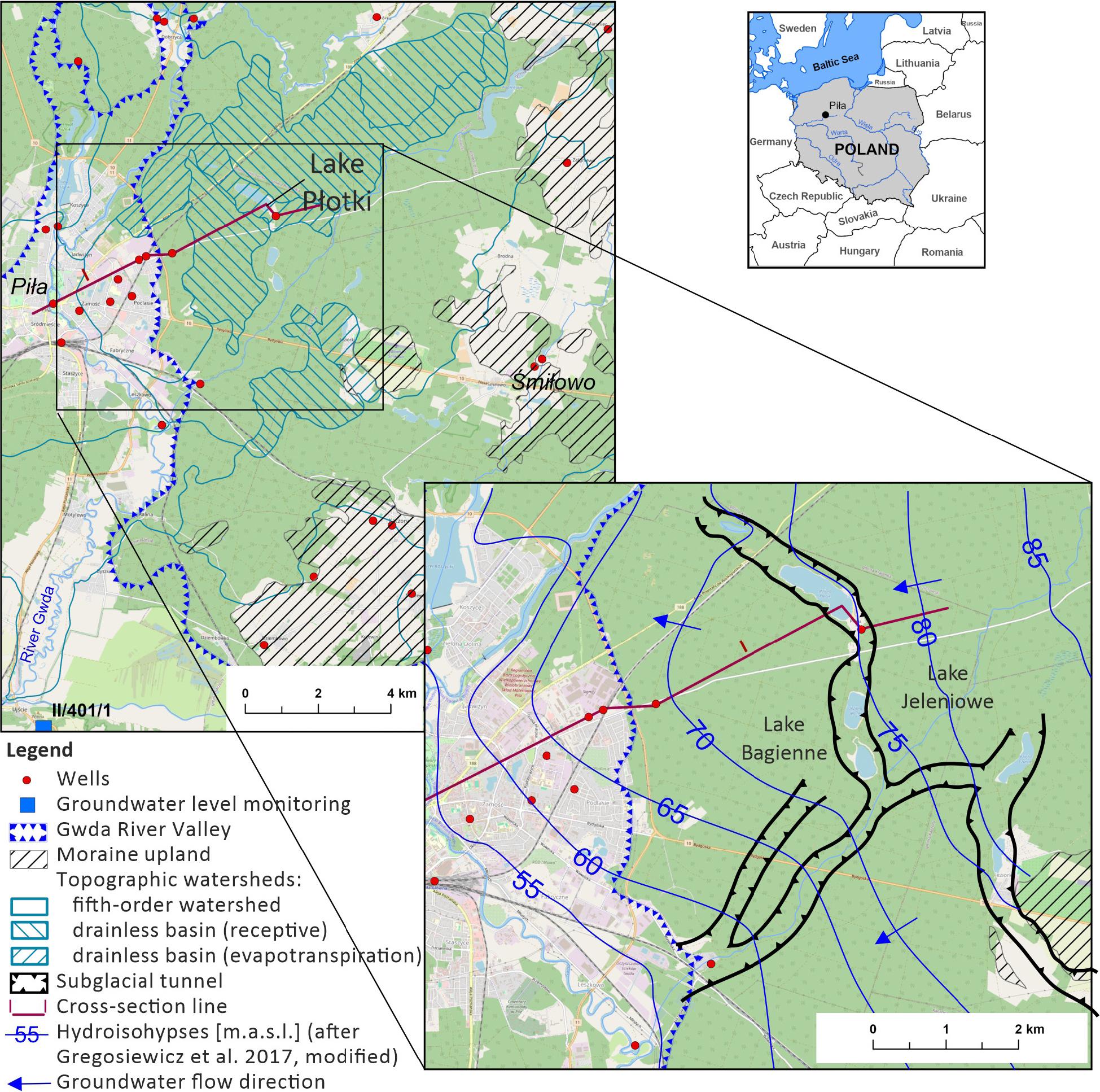
Location map of the study area.
Lake Płotki is situated 4 km east of the city of Piła in northwest Poland. The region is part of the Wielkopolska province, a water-scarce area with one of the lowest precipitation and highest air temperatures in Poland (Nowak, Ptak 2018). The lake is situated in a forest complex. It has an area of 31 ha, a maximum depth of 23.9 m and an average depth of 10.8 m (Choiński 2006). Currently, Lake Płotki is an endorheic lake of the evapotran-spirational type (Adamski 2003).
The lake is a mesotrophic reservoir with moderate nutrient content, where a population of strictly protected species (e.g. Chara aspera) occurs. The area of the lake and its surroundings are protected under the Natura 2000 programme, the ‘Ostoja Pilska’ area with code PLH300045 (Owsianny, Gąbka 2009, Journal of Laws 2023), due to the presence of natural habitats, species covered by the Directive on the Conservation of Natural Habitats and of Wild Fauna and Flora (European Commission: Directorate-General for Environment, Ecosystems Ltd, Sundseth 2015) and for its ecological value. Whereas in the lake, the natural habitat 3140 – Hard-water oligo- and mesotrophic pools with submerged meadows of Charetea brachiopods is protected. The lake is also used for recreational purposes, with a sports and recreation centre located in its southern part.
During the period covered by the study, there was no system for measuring water levels in Lake Płotki. The systematic water level measurement has been performed since 2024. According to the 2022 Numerical Terrain Model (Geoportal 2024), the shoreline elevation of Lake Płotki, and thus the approximate water level, was 74.6 m a.s.l. Three other lakes are located within the subglacial tunnel: Lake Okoniowe (to the northwest), with a shoreline elevation of 68.3 m a.s.l. and Lakes Jeleniowe and Bagienne (to the southeast), with shoreline elevations of 72.7 m a.s.l. and 72.2 m a.s.l., respectively (Fig. 1).
The hydrogeological conditions of the Lake Płotki area are poorly recognised due to an insufficient number of boreholes documenting the geological structure and groundwater levels near the lake (Fig. 1). There are three Pleistocene aquifers in this area (Fig. 2). The upper aquifer (unconfined) comprises fine-grained sands forming the outwash plain. The thickness of this aquifer does not exceed 10 m, but in the subglacial tunnel, it increases to >25 m. Given the erosional genesis of the subglacial tunnel and the fluvioglacial genesis of the sediments filling it, it can be assumed that the permeability of the sediments forming this geological structure is even better than the sediments forming the surrounding outwash plain. The deep indentation of the lake (23.9 m) into these highly permeable sediments ensures generally good hydraulic contact of the upper aquifer with surface water. The middle aquifer is formed by interglacial coarse-grained sands with a thickness of 20 m to the west of Lake Płotki and probably <5 m to the east. This aquifer is often hydraulically connected to the upper aquifer, particularly in the subglacial tunnel and in the Gwda River valley (Fig. 2). The lower aquifer (intertill), with a thickness of >20 m, is generally separated from the middle aquifer by a layer of glacial tills or mud of unknown thickness in the area of Lake Płotki (Fig. 2).
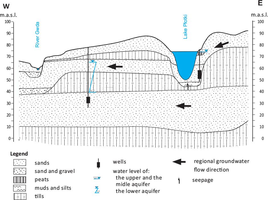
Cross-section illustrating a scheme of hydrogeological conditions in the area of Lake Płotki.
The middle and the lower aquifers are used for municipal and industrial purposes at a distance of 4–9 km from Lake Płotki (in the city of Piła and the village of Śmiłowo, Fig. 1), whilst the upper aquifer is abstracted seasonally in the summer (0.25 km south of the lake) to supply the local recreation centre.
Older aquifers are also found deeper underground (Miocene, Jurassic). These aquifers may be connected to the Pleistocene aquifers outside the study area (Kotowski, Kachnic 2016, Jamorska et al. 2019).
Lake Płotki is situated in a groundwater flowthrough zone (Fig. 1). According to Gregosiewicz et al. (2017), groundwater flows from the regional recharge area, situated in the moraine upland (east of the lake), to the regional discharge area, located in the Gwda River valley (west of the lake).
Based on geological assumptions (Fig. 2), it can be expected that most of the groundwater recharge to Lake Płotki comes from the shallowest aquifer, with the lowest water level usually in the autumn and the highest in the spring (Fig. 3). Seepage from the lower intertill aquifer may also contribute to the recharge of the lake. However, the hydrogeological borehole near the lake is too shallow to identify the groundwater level of this aquifer; thus, its contribution to the lake recharge is impossible to determine.

Groundwater levels in piezometer no. II/401/1 (PIG-PIB 2024).
Determining the interactions between the lake surface water and groundwater is difficult due to the fact that the nearest monitoring piezometer (II/401/1, Fig. 3) is located in the Gwda River valley, 15 km southwest of Lake Płotki (Fig. 1).
The VHG surveys were conducted in the hyporheic zone along Lake Płotki’s shoreline to investigate the lake’s recharge and discharge conditions and their variability during lower and higher groundwater levels. The measurements were carried out using a gradient metre, a device constructed at Adam Mickiewicz University in Poznań, Poland (Marciniak, Chudziak 2015, Marciniak et al. 2022). The gradient metre provides an in situ test to evaluate VHGs; thus, it indicates the water flow direction in the hyporheic zone. The device is suitable for testing VHGs in sandy and gravelly bed sediments of surface waters. It must be driven vertically into the lake’s bottom sediments, taking care to minimise disturbance to the sediment structure around the device. It consists of two measuring tubes, one ending with a mini-screen (groundwater level (HGw) measuring tube) pushed into the lake bed to a depth of △l = 0.2 m and the other (lake water level (HL) measuring tube) freely submerged in the lake (Figs 4A, 4B). The HGw and HL are measured, with an accuracy of 1 mm, after the differential pressure (△hup for upwelling or △hdown for downwelling) in the tubes has stabilised (Figs 4A, 4B), which usually takes a few minutes. Readings of HGw and HL are manual. VHGs are calculated by dividing △hup or △hdown by △l. A higher HL than HGw gives a negative value of VHGs, indicating downwelling, i.e. the filtration of surface water from the lake into the surrounding groundwater system, referred to herein as the lake’s discharge (Fig. 4A). On the contrary, a higher HGw than HL gives a positive value of VHGs, representing upwelling, i.e. a process whereby the lake is recharged by groundwater, referred to herein as the lake’s recharge (Fig. 4B). Further details of the gradient metre construction and methodology of the measurement are presented by Marciniak et al. (2022).
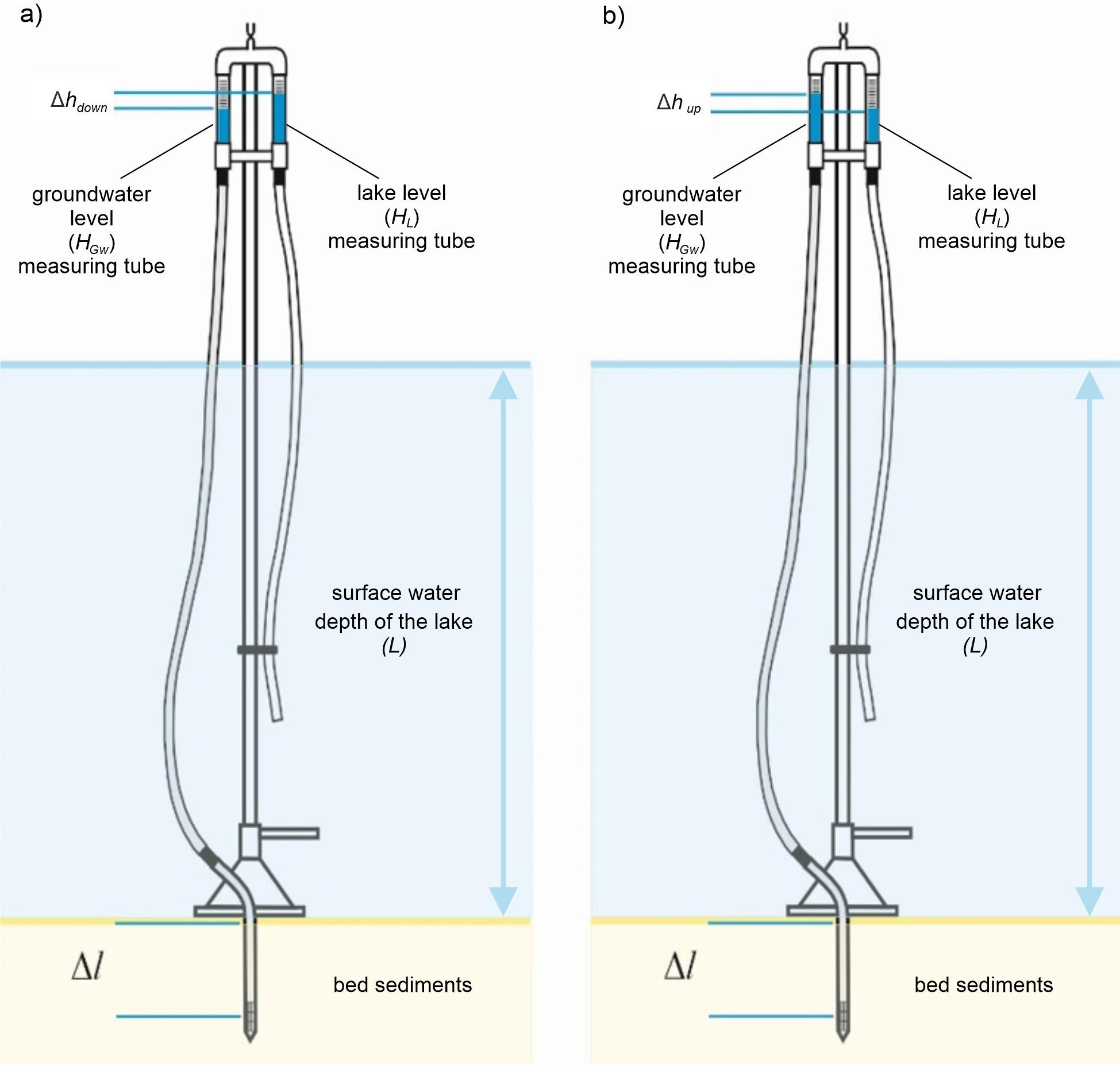
Gradient metre readings: A – under downwelling; B – under upwelling.
Two measuring campaigns were performed to investigate the VHGs. The first was undertaken in November 2022 at lower groundwater levels (Fig. 3), whilst the second was carried out in May 2023 at higher groundwater levels (Fig. 3). In the first campaign, a total of 29 testing sites were investigated (measuring points P1–P29), whilst in the second campaign, 13 testing sites were examined (measuring points P30–P42). For each measuring point, the geographical coordinates were assessed. The measuring points were located at a distance of a dozen to several dozen metres from each other along the lake’s shoreline. During the first measurement campaign, due to ambiguous readings of the gradient metre in the eastern part of the shoreline (points P8–P14), measurements were densified. In contrast, in the southwestern part of the shoreline, gradient measurements were locally impossible due to extensive overgrowth of reeds and organic sediments on the lake bottom, which clogged the screen of the gradient metre and prevented its insertion into the bottom sediments.
The results of the gradientmetric measurements are presented in Table 1, whilst the spatial differentiation of VGHs along the shoreline of Lake Płotki is presented in Figure 5. The green colour represents upwelling, whilst the red colour represents downwelling in the hyporheic zone. For better clarity of the results, the multiplier of 100 was used in Figure 5 and the text of the article.
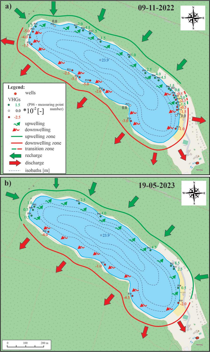
Spatial distribution of VHGs in the Lake Płotki shoreline zone: A – in November 2022; B – in May 2023. Isobaths according to Jańczak (1996). VHGs, vertical hydraulic gradients.
Results of gradientmetric measurements along the shoreline of Lake Płotki in autumn 2022 and spring 2023. MP, Measuring point; VHG, vertical hydraulic gradient.
| 09-11-2022 | 19-05-2023 | |||||||||||||
|---|---|---|---|---|---|---|---|---|---|---|---|---|---|---|
| MP | L | HGw | HL | VHG | MP | L | HGw | HL | VHG | MP | L | HGw | HL | VHG |
| [m] | [mm] | [–] | [m] | [mm] | [–] | [m] | [mm] | [–] | ||||||
| P01 | 0.49 | 63 | 60 | 0.015 | P16 | 0.45 | 79 | 85 | –0.030 | P30 | 0.40 | 60 | 52 | 0.040 |
| P02 | 0.15 | 49 | 47 | 0.010 | P17 | 0.58 | 89 | 89 | 0.000 | P31 | 0.49 | 85 | 76 | 0.045 |
| P03 | 0.23 | 65 | 60 | 0.025 | P18 | 0.48 | 86 | 90 | –0.020 | P32 | 0.44 | 83 | 66 | 0.085 |
| P04 | 0.53 | 47 | 39 | 0.040 | P19 | 0.44 | 96 | 106 | –0.050 | P33 | 0.43 | 90 | 85 | 0.025 |
| P05 | 0.34 | 69 | 60 | 0.045 | P20 | 0.53 | 35 | 42 | –0.035 | P34 | 0.55 | 41 | 40 | 0.005 |
| P06 | 0.46 | 55 | 52 | 0.015 | P21 | 0.23 | 61 | 66 | –0.025 | P35 | 0.29 | 31 | 35 | –0.020 |
| P07 | 0.36 | 80 | 78 | 0.008 | P22 | 0.34 | 65 | 68 | –0.015 | P36 | 0.72 | 50 | 59 | –0.045 |
| P08 | 0.49 | 92 | 93 | –0.005 | P23 | 0.33 | 27 | 35 | –0.040 | P37 | 0.38 | 73 | 75 | –0.010 |
| P09 | 0.34 | 99 | 95 | 0.020 | P24 | 0.94 | 70 | 80 | –0.050 | P38 | 0.26 | 56 | 64 | –0.040 |
| P10 | 0.48 | 75 | 79 | –0.023 | P25 | 0.47 | 50 | 47 | 0.015 | P39 | 0.25 | 60 | 59 | 0.005 |
| P11 | 0.51 | 95 | 92 | 0.015 | P26 | 0.39 | 55 | 55 | 0.000 | P40 | 0.38 | 85 | 84 | 0.005 |
| P12 | 0.21 | 39 | 40 | –0.005 | P27 | 0.35 | 104 | 100 | 0.020 | P41 | 0.27 | 84 | 82 | 0.010 |
| P13 | 0.18 | 66 | 69 | –0.015 | P28 | 0.35 | 78 | 69 | 0.045 | P42 | 0.35 | 76 | 71 | 0.025 |
| P14 | 0.40 | 98 | 98 | 0.000 | P29 | 0.41 | 65 | 62 | 0.015 | |||||
| P15 | 0.51 | 90 | 92 | –0.010 | ||||||||||
In the first measuring campaign (09-11-2022), the distribution of positive VHGs revealed the existence of a continuous upwelling zone (Fig. 5A) along the northeastern sections of the shoreline (from points P25 to P07), about 1.1 km long. The downwelling zone indicated by negative VHGs was much more extensive (1.7 km), covering generally the southwestern sections of the shoreline (from points P12 to P24). A short 0.1 km section in the southeastern part of the lake (from points P08 to P11), where both upwelling (P09, P11) and downwelling (P08, P10) were observed, was classified as a transition zone. In this section, the hydraulic gradients were very low (close to zero). Thus, the accuracy of the gradient metre did not allow the determination of whether the zone was upwelling or downwelling.
In the second measuring campaign (19-05-2023), the extent of the upwelling zone increased to 1.5 km (P30–P34 and P39–P42) and the extent of the downwelling zone shortened to 1.4 km (P35–P38). A change in flow directions (from downwelling to upwelling) was found in the northwestern and southeastern shoreline sections (P23–P25 and P08–P14), as indicated by VHG values at points P32, P33, P34 and P39–P40 (Fig. 5B). Statistical parameters indicate a higher variability of VHGs in the second measurement campaign. The coefficient of variation for VHGs measured in autumn 2022 (at 29 points) was almost 60%, whilst for spring 2023 (at 13 points) it was >90% (Table 2). The higher changeability of VHGs in spring 2023 may be the reason for the significant shortening of the transition zone and, consequently, its failure to be captured by VHG measurements in this campaign.
Statistical characteristics of the vertical hydraulic gradient (VHG) measurements.
| Hyporheic exchange | N | VHG [–] | ||||||
|---|---|---|---|---|---|---|---|---|
| [-] | [%] | MIN | AV | MD | MAX | SD | V | |
| 09-11-2022 | ||||||||
| Upwelling | 13 | 44.8 | 0.008 | 0.022 | 0.015 | 0.045 | 0.012 | 55.8% |
| Neutral | 3 | 10.8 | ||||||
| Downwelling | 13 | 44.8 | –0.050 | –0.025 | –0.023 | –0.005 | 0.015 | –59.6% |
| 19-05-2023 | ||||||||
| Upwelling | 9 | 69.2 | 0.005 | 0.027 | 0.025 | 0.085 | 0.025 | 91.7% |
| Neutral | 0 | 0 | ||||||
| Downwelling | 4 | 30.8 | –0.045 | –0.029 | –0.030 | –0.010 | 0.014 | –49.8% |
The statistical characteristics of the VHG measurements for both measuring campaigns (Table 2) also indicate that in both campaigns, the absolute values of average upwelling gradients (2.22 · 10−2 and 2.72 · 10−2) were smaller than the average gradients of downwelling (2.48 · 10−2 and 2.88 · 10−2). Similar changes indicate the median calculations.
Recognising the extent of downwelling and upwelling in the hyporheic zone of Lake Płotki allows us to indicate the zones where the lake is recharged by groundwater (lake’s recharge) and the zones where lake water filtrates into the groundwater system (lake’s discharge).
The presence of upwelling zones (generally in the northeastern section of the lake’s shoreline) indicates parts of the lake system where the lake’s recharge occurs, whilst the presence of downwelling zones (generally in the southwestern sections of the lake’s shoreline) indicates parts of the lake system where the lake’s discharge occurs (Fig. 5). The general orientation of these zones is influenced by regional hydrogeology, particularly the distribution of the regional recharge and the discharge areas, which determines the groundwater flow directions (Smith, Townley 2002). The orientation of the upwelling zone towards the regional recharge area in the moraine upland and the downwelling zone towards the Gwda River valley (Fig. 5) indicates that Lake Płotki is a flow-through lake in the regional groundwater flow system (Fetter 1994, Smith, Townley 2002). This pattern is consistent with the distribution of the lake’s recharge and discharge zones, often documented in the literature for groundwater-dependent lakes (Kidmose et al. 2011, Rudnick et al. 2015).
On the local scale, periodical changes in the direction of water flow in the lake hyporheic zone (from upwelling to downwelling) indicate parts of the lake system that are most sensitive to changes in hydrological and hydrogeological conditions. These are located in the northwestern and southeastern sections of the shoreline, where the subglacial tunnel occurs (Fig. 1). This deep geological structure may have a significant impact on groundwater circulation conditions (Dobracka, Lewandowski 2002). In periods when these zones undergo a periodic transition from the lake’s recharge to the lake’s discharge, this tunnel may provide a preferential underground flow path for water discharged from Lake Płotki towards neighbouring Lakes Jeleniowe and Bagienne and Lake Okoniowe. This hypothesis is supported by the highest shoreline elevation of Lake Płotki compared to other lakes in the tunnel (Geoportal 2024), which suggests that a local watershed (not detectable on a regional scale, Fig. 1) may periodically form in the area of Lake Płotki.
The configuration of the downwelling and upwelling zones found from the gradientmetric measurements indicates that, in parts of the Lake Płotki shoreline located in the section where the subglacial tunnel occurs (Fig. 1), the lake’s discharge takes place mainly during lower levels of groundwater (as in November 2022).
The research indicates the occurrence of hyporheic exchange in the lake shoreline. The presented results allow for the development of the conceptual model of the hyporheic exchange in the shoreline of the lake located in the flow-through zone of the regional groundwater flow system (Fig. 6). This model is slightly different from models often presented for rivers, in which the hyporheic flow is usually distinguished from groundwater due to its bidirectional nature (Boano et al. 2014).
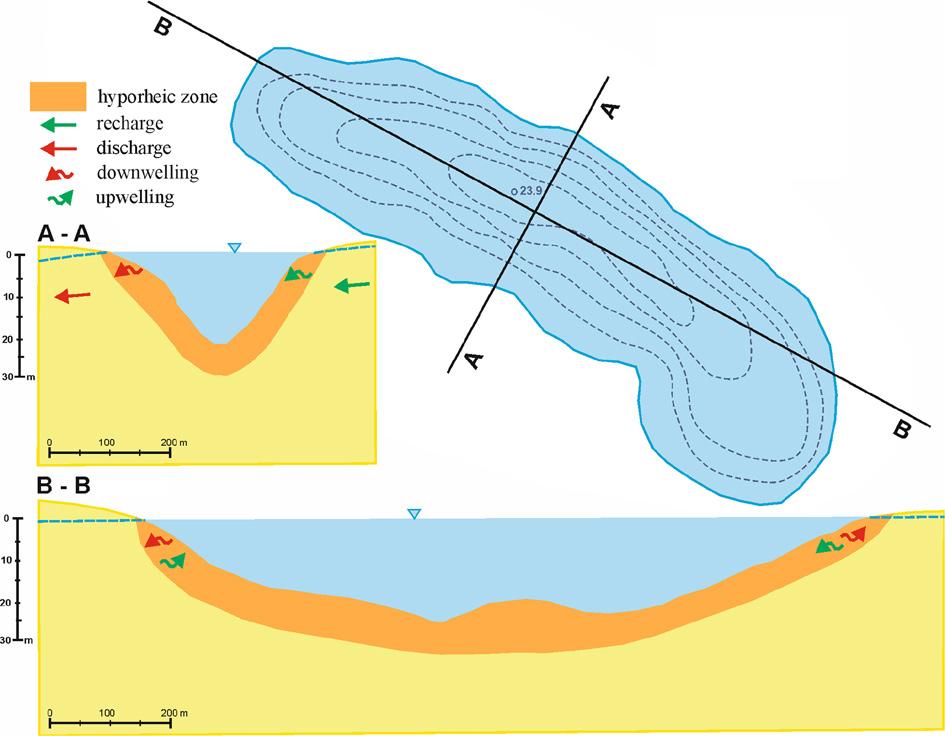
Conceptual model of the hyporheic zone functioning in the shoreline of Lake Płotki.
The model proposed in this study assumes that in zones of constant upwelling and downwelling, positioned perpendicularly to the regional groundwater flow direction, a unidirectional water exchange (to or from the lake, Fig. 6A-A) dominates, resulting from the flow-through character of the lake in the regional groundwater flow system. Different water circulation occurs in the parts of the lake shoreline located in the subglacial tunnel situated perpendicular to the regional groundwater flow direction. In these zones, a bidirectional water exchange dominates (Fig. 6B-B) as a consequence of a periodic change from downwelling (as in the autumn 2022, at lower groundwater levels) to upwelling during the rise in groundwater levels (as in spring 2023), making the lake recharge more effective.
These dominating flow directions, presented in the diagram (Fig. 6), may be locally disturbed, for example, by uneven bottom sediments (Packman, Salehin 2003, Song et al. 2016, Busato et al. 2019), obstructing materials deposited on the lake bottom (rocks, wood fragments) or underwater plants (Tonina, Buffington 2007, Swanson, Bayani Cardenas 2010, Marzadri et al. 2016, Marttila et al. 2019). Such disturbances may also be caused by ripples on the lake surface, resulting from stronger winds or motorboats (Roche et al. 2018), as well as fish penetrating bottom sediments in search of food (Mugnai et al. 2015), groundwater abstraction (Kotowski et al. 2023) or even the phenomenon of the lake bed sediments fluidisation noticed by scuba divers in Lake Płotki.
The presented gradient metre-based studies of the lake hyporheic zone allow the qualitative assessment of the lake’s recharge and discharge conditions. A comparison of the results from both measuring campaigns indicates that in spring 2023, the conditions for recharging the lake were more favourable than in autumn 2022. This is confirmed by the lengthening of the upwelling zone (from 1.1 km in autumn 2022 to 1.4 km in spring 2023) and the concurrent shortening of the downwelling zone (from 1.7 km to 1.5 km, respectively). This is consistent with findings in the literature (Liu et al. 2022). However, the higher average gradients of downwelling than the gradients of upwelling may indicate that the lake’s discharge prevailed over its recharge in both measuring campaigns. Prolonged maintenance of these conditions can lead to a decline in the lake water level, especially during droughts.
All these observations show that measuring the variability of VHGs can accurately determine the lake’s recharge and discharge conditions, as the hyporheic zone is a very sensitive indicator of water flow directions. It is worth noting that using a gradient metre may be advantageous over other hydraulic methods (e.g. measurements in piezometers or wells), as it allows for the determination of the pressure difference between surface water and groundwater in the hyporheic zone. This gives an indication of the extent of the lake’s recharge and discharge zones without knowing the absolute level of water in the lake and groundwater. The application of these studies may have practical implications as a basis for identifying the location of boreholes for environmental monitoring or calibrating numerical models of groundwater flow. Therefore, the presented method is recommended as a preliminary step in the lake recharge studies, especially in the case of relatively poor recognition of the hydrogeological conditions.
However, it should be emphasised that to quantitatively assess the lake’s recharge and discharge, more detailed investigations of the hydrogeological conditions are required. The investigation should involve the identification of the aquifers/aquitard geometry and their hydraulic properties, as well as the investigation of the groundwater flow pattern (Nield et al. 1994, Townley, Trefry 2000).
The investigation of the upwelling and downwelling zones in the hyporheic zone of Lake Płotki, performed with the use of the gradient metre, allows us the recognisation of the interaction of the surface water/groundwater interaction in the conditions of a lack of detailed investigation of the surface and groundwater levels.
The research confirms the assumption of the lake flow-through character in a groundwater flow system. The constant upwelling in the lake hyporheic zone indicates lake recharge by groundwater inflow, whilst the constant downwelling zone indicates lake water filtration into the groundwater system. Moreover, the research indicates the creation of the local watershed, which facilitates the seepage of water from the lake to the groundwater system. The periodic changes in the upwelling/downwelling zones were documented. The extent of the upwelling zone in the period of lower water level (autumn 2022) was significantly lower than the extent of the downwelling zone. In the periods of lower groundwater level occurring more and more often in the last decades, these conditions may contribute to a gradual decrease in the water level in the lake. This situation may be the result of both hydrological changes and excessive groundwater exploitation in the region.
The present gradient metre-based studies of the lake hyporheic zone allow the formulation of the conceptual model of surface/groundwater interaction in the case of a flow-through lake situated in the regional groundwater flow system. Such models are most often presented for rivers or streams in the literature, whereas hyporheic zones of standing water are rarely studied.
The studies showed that the gradient metre can be used in the investigation of the upwelling and downwelling of the lake’s hyporheic zone. The high sensitivity of the device ensures that it can operate at low hydraulic gradients, which may occur in the area of flow-through lakes. Limitations include organic sediments or rocky lake bottoms that preclude placing the device on the lake bottom.
The results presented make a significant contribution to the investigation of the water balance in the lake system, especially in the context of lake recharge by groundwater because they provide crucial ideas for designing a hydrosphere monitoring network in the lake area. This is especially important in the regions where the overall investigation of hydrogeological conditions (especially groundwater flow patterns) is relatively scarce.