
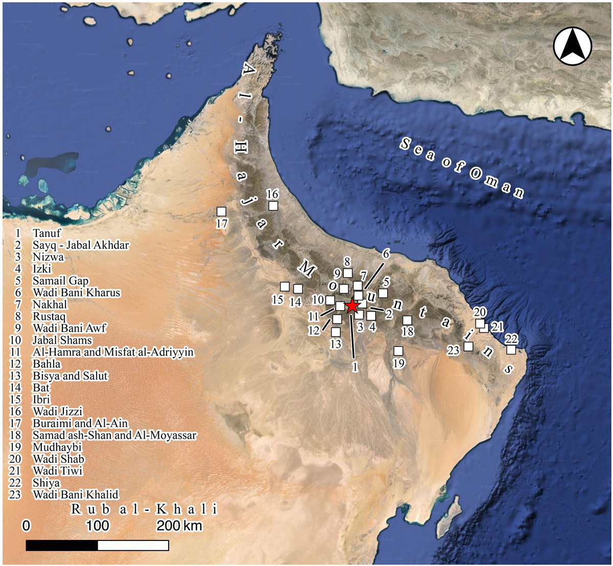
Figure 1
The land of Southeast Arabia and the location of toponym and archaeological sites mentioned in the text. Basemap: Google Maps applied with QGIS.
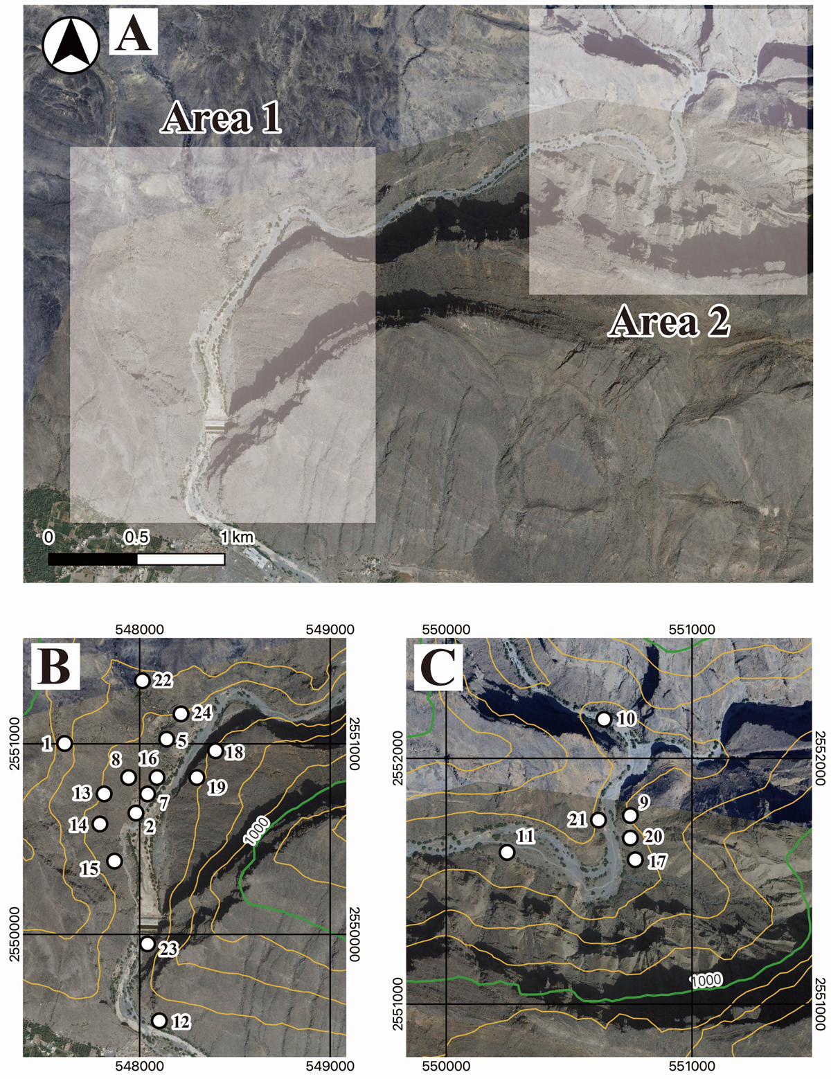
Figure 2
Satellite imagery of the Tanuf Canyon and the investigated areas. A) Location of Areas 1 and 2. B) Distribution of archaeological sites in Area 1. The numbers with white dots in the figure indicate the sites’ WTN name. C) Distribution of archaeological sites in Area 2. The location of the sites is indicated as the cases in B). The coordinate system is UTM40Q. All background images: AW3D Ortho Imagery © DigitalGlobe, Inc., NTT Data Corporation and Google Maps applied with QGIS. Contours are applied to the ASTER GDEM model with QGIS. White lines indicate the contours in the 100 m interval, while bold purple lines indicate those in the 1000 m interval. The background is ASTER-VA image (ASTER-VA image courtesy NASA/METI/AIST/Japan Spacesystems, and US/Japan ASTER Science Team). See https://gdemdl.aster.jspacesystems.or.jp/index_en.html for details.
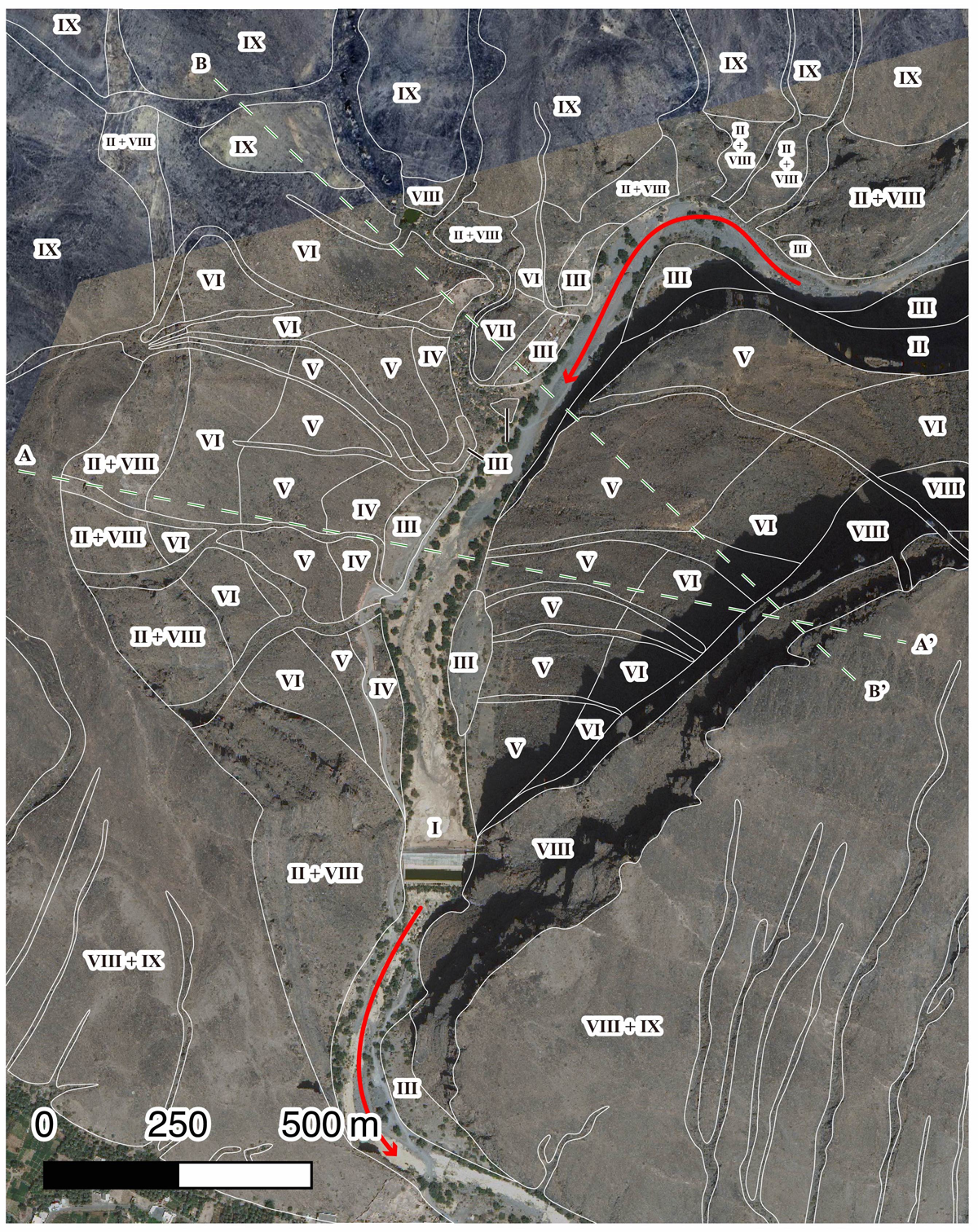
Figure 3
Classified topography in Area 1. Roman numerals indicate the topographical classes defined in the main text, whose supposed boundaries are indicated by the white lines. The red arrow indicates the flowing direction of Wadi Tanuf. The green broken lines indicate the location of the sections presented in Figure 5. All background images: AW3D Ortho Imagery © DigitalGlobe, Inc., NTT Data Corporation and Google Maps applied with QGIS.
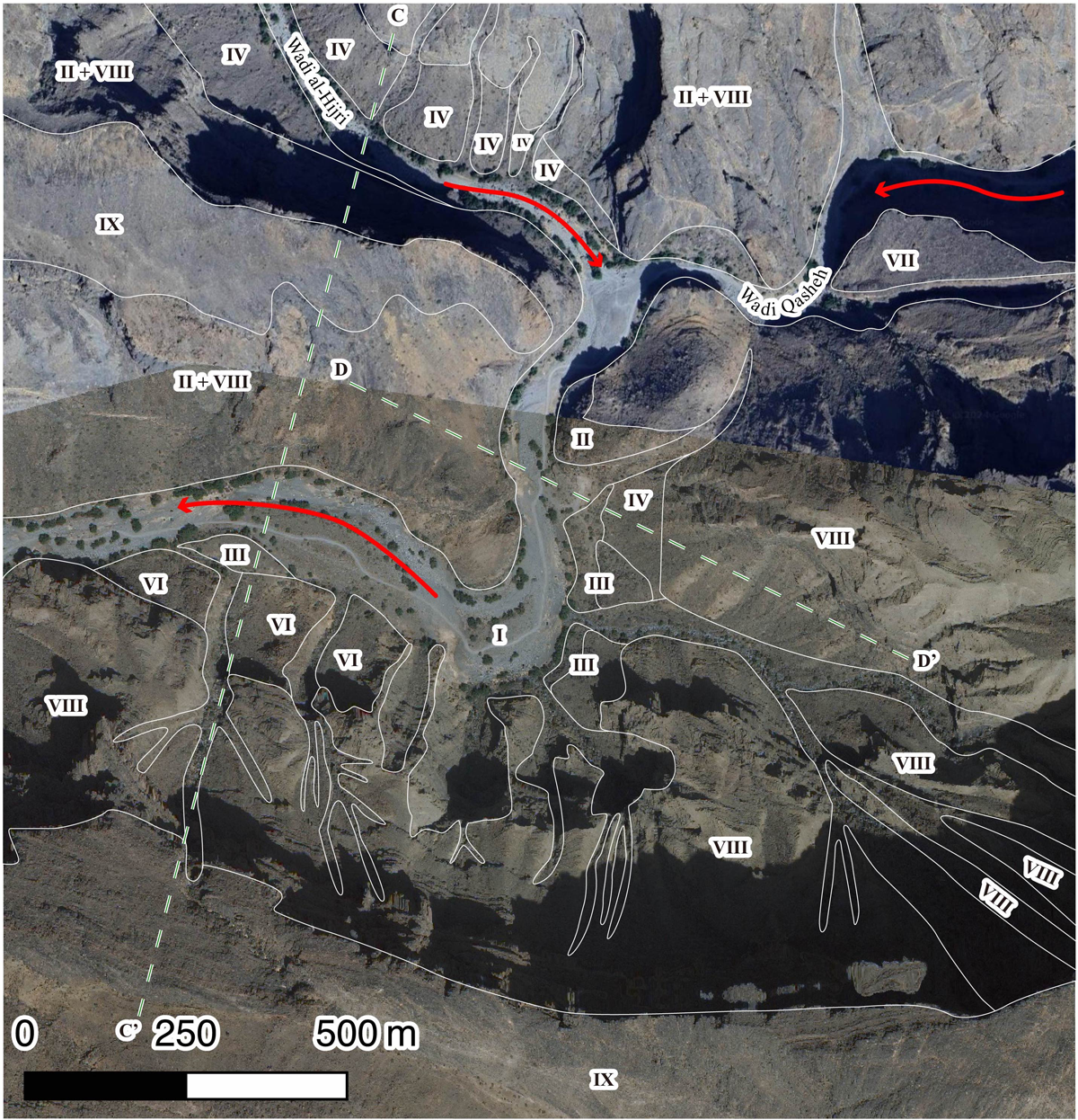
Figure 4
Classified topography in Area 2. Roman numerals indicate the topographical classes defined in the main text, whose supposed boundaries are indicated by the white lines. The red arrow indicates the flowing direction of Wadi Tanuf. The green broken lines indicate the location of the sections presented in Figure 5. All background images: AW3D Ortho Imagery © DigitalGlobe, Inc., NTT Data Corporation and Google Maps applied with QGIS.
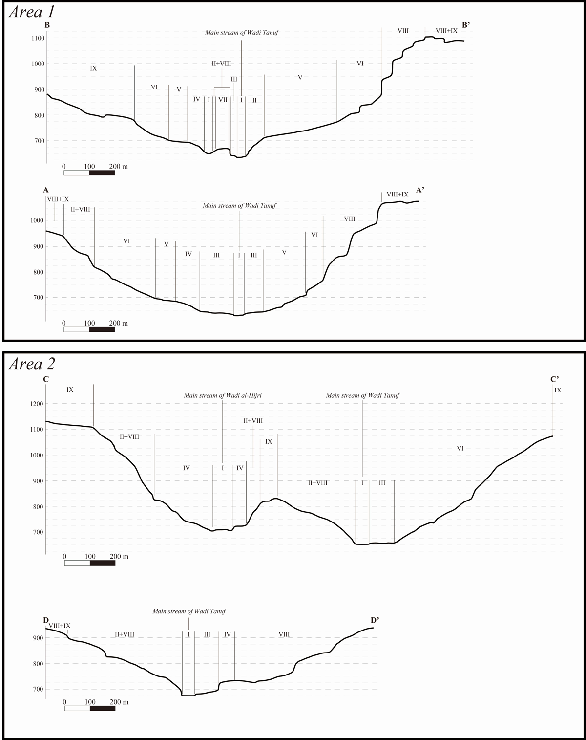
Figure 5
The schematic sections of Tanuf Canyon in Areas 1 and 2 based on ASTER GDEM. Roman numerals indicate the topographical class defined in the main text. The location of the sections is indicated in Figures 3 and 4 in broken green line.
Table 1
Summary of the discovered sites in each period at the defined topographical classes.
| WTN | AREA | TOPOGRAPHY | TOPOGRAPHY TYPE | EARLY HOLOCENE BEFORE 3300 BCE | HAFIT 3300–2700 BCE | UMM AN-NAR 2700–2000 BCE | WADI SUQ 2000–1600 BCE | LATE BRONZE AGE 1600–1300 BCE | EARLY IRON AGE 1300–300 BCE | LATE IRON AGE 300 BCE – 630 CE | ISLAMIC 630 CE– |
|---|---|---|---|---|---|---|---|---|---|---|---|
| 01 | 1 | VIII | High Cliff | – | X | X | X | X? | X | X? | X |
| 02 | 1 | III | Terrace | – | – | – | – | – | X | – | X |
| 05 | 1 | VII | Isolated Plateau | – | X | X? | – | – | – | – | X |
| 07 | 1 | III | Terrace | – | – | – | X | – | X | – | X |
| 08 | 1 | IV + V | Lower Steep Talus Slope + Higher Gentle Talus Slope | – | X | – | X? | – | X | – | X |
| 09 | 2 | II | Low Cliff | X? | – | – | – | – | – | – | – |
| 10 | 2 | I | Wadi Bed | – | – | – | – | – | X | X? | X |
| 11 | 2 | III | Terrace | – | – | – | – | – | – | – | X |
| 12 | 1 | II | Low Cliff | – | – | – | – | – | – | – | X |
| 13 | 1 | IV + V | Lower Steep Talus Slope + Higher Gentle Talus Slope | – | X | – | X | – | X | – | X |
| 14 | 1 | V | Higher Gentle Talus Slope | – | – | – | X | – | X | – | – |
| 15 | 1 | V | Higher Gentle Talus Slope | – | X | – | – | – | X | – | X |
| 16 | 1 | III | Terrace | – | X | – | – | – | – | X? | X |
| 17 | 2 | III | Terrace | – | X | – | – | – | X | – | – |
| 18 | 1 | VI | Higher Steep Talus Slope | – | X | – | – | – | X? | X? | – |
| 19 | 1 | VI | Higher Steep Talus Slope | – | X | – | – | – | – | – | – |
| 20 | 2 | III | Terrace | – | – | – | – | – | X? | – | – |
| 21 | 2 | I | Wadi Bed | X? | X | X | – | – | X | X? | X |
| 22 | 1 | IX | Mountain Plateau | – | X | – | – | – | – | – | – |
| 23 | 1 | I | Wadi Bed | – | – | – | X | – | X | – | X |
| 24 | 1 | VI | Higher Steep Talus Slope | – | X | – | – | – | – | – | – |
Table 2
Summary of site types and defined topographical classes in Area 1.
| WTN | AREA | TOPOGRAPHY | TOPOGRAPHY TYPE | CEMETERY | LIVING PLACE | CAVE USE | ROCK-ART | FORTIFICATION | PASTORAL |
|---|---|---|---|---|---|---|---|---|---|
| 01 | 1 | VIII | High Cliff | – | – | X | – | – | – |
| 02 | 1 | III | Terrace | X | X | – | – | – | – |
| 05 | 1 | VII | Isolated Plateau | X | – | – | – | X | – |
| 07 | 1 | III | Terrace | X | X | – | – | – | – |
| 08 | 1 | IV + V | Lower Steep Talus Slope + Higher Gentle Talus Slope | X | – | – | – | – | X |
| 12 | 1 | II | Low Cliff | – | – | X | X | – | – |
| 13 | 1 | IV + V | Lower Steep Talus Slope + Higher Gentle Talus Slope | X | – | – | X | – | – |
| 14 | 1 | V | Higher Gentle Talus Slope | X | – | – | – | – | – |
| 15 | 1 | V | Higher Gentle Talus Slope | X | X | – | – | – | – |
| 16 | 1 | III | Terrace | X | – | – | – | – | – |
| 18 | 1 | VI | Higher Steep Talus Slope | X | – | – | – | – | – |
| 19 | 1 | VI | Higher Steep Talus Slope | X | X? | – | – | – | – |
| 22 | 1 | IX | Mountain Plateau | X | – | – | – | – | – |
| 23 | 1 | I | Wadi Bed | – | – | – | X | – | – |
| 24 | 1 | VI | Higher Steep Talus Slope | X | – | – | – | – | – |
Table 3
Summary of site types per defined topographical categories in Area 2.
| WTN | AREA | TOPOGRAPHY | TOPOGRAPHY TYPE | CEMETERY | LIVING PLACE | CAVE USE | ROCK-ART | FORTIFICATION | PASTORAL |
|---|---|---|---|---|---|---|---|---|---|
| 09 | 2 | II | Low Cliff | – | – | X | – | – | – |
| 10 | 2 | I | Wadi Bed | – | – | – | X | – | – |
| 11 | 2 | III | Terrace | X | – | – | – | – | – |
| 17 | 2 | III | Terrace | X | – | – | – | – | – |
| 20 | 2 | III | Terrace | X | – | – | – | – | – |
| 21 | 2 | I | Wadi Bed | – | – | – | X | – | – |
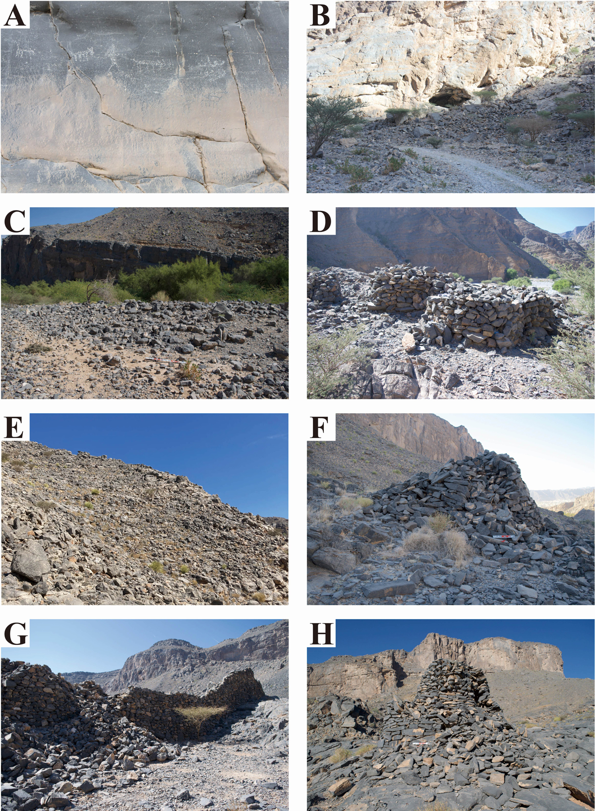
Figure 6
A) Rock art panels of WTN10 beside the Wadi Bed. B) Cave of WTN09 on the Low Cliff. C) Cemetery of WTN16 on the Terrace. D) Cemetery of WTN17 on the Terrace. E) Cemetery of WTN24 on the Higher Steep Talus Slope. F) Cemetery of WTN18 on the Higher Gentle Talus Slope. G) Islamic fort of WTN05 on the Isolated Plateau. H) Cemetery of WTN22 on the Mountain Plateau.
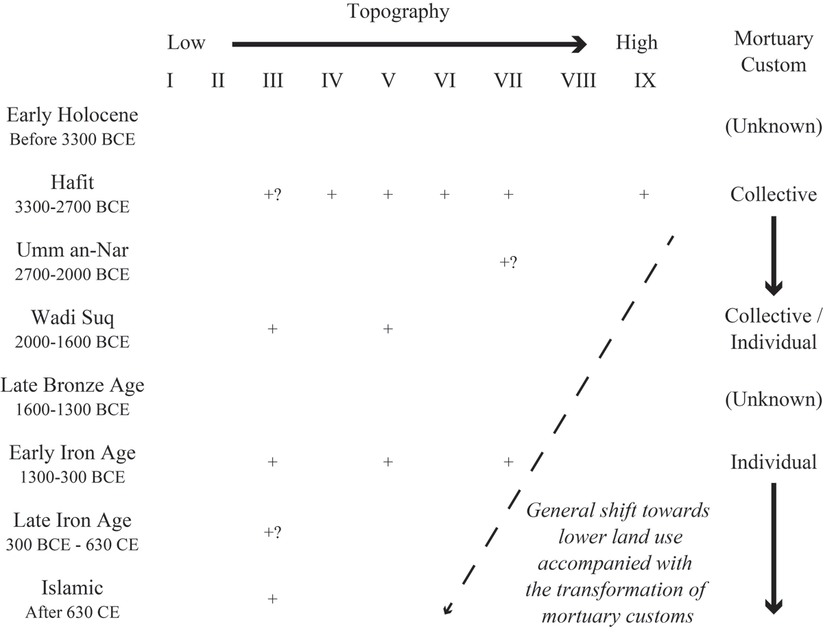
Figure 7
Diachronic shift of locations for cemeteries in Areas 1 and 2. The letter ‘+’ indicates the presence of archaeological evidence.
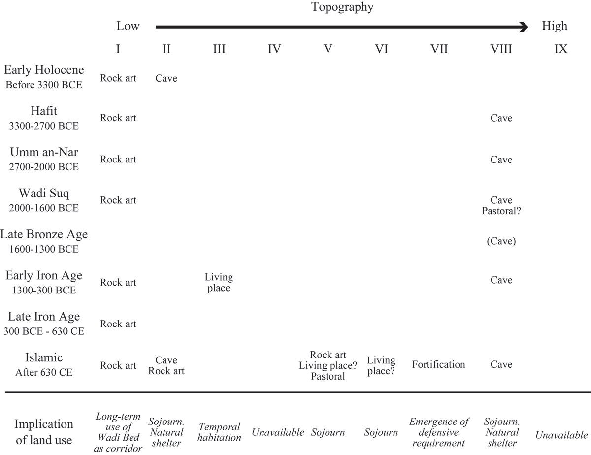
Figure 8
Diachronic overview of land use for non-mortuary purposes in Areas 1 and 2.
Table 4
Summary of land use transformation in the millennial scale.
| TOPOGRAPHY | I | II | III | IV | V | VI | VII | VIII | IX | |||||||||
|---|---|---|---|---|---|---|---|---|---|---|---|---|---|---|---|---|---|---|
| Activity type | Mortuary | Non-Mortuary | Mortuary | Non-Mortuary | Mortuary | Non-Mortuary | Mortuary | Non-Mortuary | Mortuary | Non-Mortuary | Mortuary | Non-Mortuary | Mortuary | Non-Mortuary | Mortuary | Non-Mortuary | Mortuary | Non-Mortuary |
| Early Holocene Before 3300 BCE | Rock art | Cave | ||||||||||||||||
| Hafit 3300–2700 BCE | Rock art | Collective tombs? | Collective tombs | Collective tombs | Collective tombs | Collective tombs | Cave | Collective tombs | ||||||||||
| Umm an-Nar 2700–2000 BCE | Rock art | Collective tombs? | Cave | |||||||||||||||
| Wadi Suq 2000–1600 BCE | Rock art | Collective tombs | Individual tombs | Cave Pastoral? | ||||||||||||||
| Late Bronze Age 1600–1300 BCE | (Cave) | |||||||||||||||||
| Early Iron Age 1300–300 BCE | Rock art | Individual tombs | Living place | Individual tombs | Cave | |||||||||||||
| Late Iron Age 300 BCE-630 CE | Rock art | Individual tombs? | ||||||||||||||||
| Islamic After 630 CE | Rock art | Cave Rock art | Individual tombs | Rock art Living place? Pastoral facility | Living place? | Fortification | Cave | |||||||||||