
Introduction
During fieldwork related to the geological mapping for Sheet 1373 Mendrisio (part East), with part West of the sheet Como, of the Geological Atlas of Switzerland 1:25,000 (Map n. 152; Bernoulli et al. 2017), a particular standing stone was found near Velmaio, on the valley floor of the Torrente Bévera, by Claudio Castelletti on the 24 January 2013. Because of its exotic lithology, the situation of the boulder lying on fluvial deposits derived from glacial and fluvioglacial deposits, the presence of ablation till deposits in the neighbouring areas, and the lack of geological and/or archaeological relevant literature, we interpreted the stone first as an erratic block.
Erratic boulders are indeed frequently present in the valleys south of Lago Maggiore (Verbano) and Lago di Lugano (Ceresio) and could therefore be considered witnesses of the piedmont glaciers of the Ticino-Toce and (partially) the Adda-Ticino glacier systems during the last glaciations, in particular during the Last Glacial Maximum (LGM; see Monegato et al. 2022; and references therein). Earlier publications dealt mainly with the distribution and the lithological composition of erratic boulders, in particular of the moraine ridges of the Verbano amphitheatre (Omboni 1861; Salmojraghi 1882; Sacco 1892; CAI 1914; Hantke 1983; Bini 1997; Bini et al. 2014). During the last years, in addition to the maps of the 19th and 20th century, the lithological composition of the erratic boulders, the extension of the glaciers during the LGM (Bini et al. 2009; Seguinot et al. 2018) and the chronology of glacier advance and deglaciation in the Orta and Verbano basins (Ticino-Toce glacier system; Braakhekke et al. 2020; Kamleitner et al. 2022) and the Ceresio basin (Adda-Ticino glacier system; Scapozza et al. 2014; Bernoulli et al. 2018) were investigated. A synoptic analysis of the location and the lithology of more than 500 erratic boulders in the Verbano and Ceresio amphitheatres also allowed a reconstruction of the ice conveyor belts during the LGM (Monegato et al. 2022). The use of far-travelled erratic blocks of crystalline basement rocks in sedimentary or unconsolidated formations has been well documented (e.g. Reynard 2004; Pellegrini et al. 2005; Motta & Motta 2012).
Based on our detailed observations, we developed the hypothesis that the standing stone of Velmaio is, with all probability, a megalith. Accordingly, the boulder was described and mapped as a megalith on the Geological Atlas of Switzerland 1:25,000 (Bernoulli et al. 2017).
The presence of megaliths in the Swiss-Italian border area between Lago Maggiore and Lago di Lugano and the valleys south of both lakes is poorly documented. In this area no menhirs are known that could be dated to the Neolithic or the Chalcolithic periods (Gallay 2010; SSDI 2022), even if megalithic occurrences and petroglyphs were described for example from Porto Ceresio (Varese), on the southern shores of Lago di Lugano (Pirondini et al. 2013), and in Proserpio, east of Como (Pozzi 2017). In the absence of clear archaeological evidence and of chronological data, the megalithic character of these occurrences is not proved (Schwegler 1992). However, in the neighbourhood of Velmaio, several archaeological sites that belong to the Golasecca culture (900–400 BCE), Late Bronze Age/Early Iron Age, are documented (e.g. Negroni Catacchio 1979; De Marinis 1985; De Marinis 2012; De Marinis et al. 2009).
From up-valleys of Lago Maggiore and Lago di Lugano, there are only two reports of megaliths: 1. the standing stones without inscriptions (“cippi”) placed over the roofs of a few tombs of the protohistoric necropolis of Progero Gudo (Cantone Ticino, Switzerland), dated to the Iron Age and belonging to the Golasecca culture (Sormani 2007; Sormani 2012a; Sormani 2012b; Biaggio-Simona 2017). 2. The megalithic site of Claro (Cantone Ticino, Switzerland), discovered and well documented between 2018 and 2021 (Federici-Schenardi & Gillioz 2020; Federici-Schenardi & Gillioz 2021; Federici-Schenardi & Gillioz 2022; Biaggio-Simona 2023). This site is unique in the entire subalpine region and of high archaeological value on a national level. It is the first monumental evidence testifying to prehistoric religion in Cantone Ticino. It represents at the same time the oldest evidence of both, the territorial organisation of the population settled in the Bellinzona area and of sculptural stone-working activity (with symbolic and aesthetic purposes) in Cantone Ticino (Dipartimento del territorio 2019).
In this contribution, we discuss, in detail and for the first time, the distinctive characteristics and the significance of the standing stone of Velmaio based on its morphology, lithology, and surface exposure age. Our objective is to reconstruct the long and complex history of this fascinating boulder, and its journey, first by glacial transport during the Late Pleistocene, then by human transport and the final instalment as a probable megalith during the Middle Holocene.
Material and methods
Morphological analysis
The geoarchaeological analysis of megaliths allows to recognize anthropic signatures linked to the transformation of the material, by differentiating pre-megalithic traces from post-megalithic ones, i.e. those realised before or after the erection of the stone (e.g. Sellier 1991; Sellier 2013). In this study, we applied the protocol following the interpretation grids that were established for the study of the menhirs and orthostats of megalithism in western France (e.g. Mens 2008; Mens 2009; Cousseau 2020; Cousseau 2023). The following three groups of traces were analysed:
Weathered and fresh faces of the block, which correspond to the eroded and pull-out faces torn from the bedrock. The objective of this distinction is to be able to reconstruct the original position of the stone in the original outcrop and to locate the fractured edges on it. It is on these edges that the traces of quarrying (point 2) can be identified.
Traces linked to the megaliths quarrying, for example tool impacts, rubbing (fire allows to break up the rock) or notches driven into the rock to introduce a lever or a wooden wedge used to detach a monolith from the outcrop.
Traces of shaping of the block, to adapt it to its future location and functionality. They include traces of bush-hammering, hammering and material removal to modify the general shape of the boulder or the micromorphology of its surfaces. These traces show stone cutting work or surface treatment on the block.
For monoliths that are currently in vertical position, traces of erosion such as potholes, water channels of drapery were looked for and classified into two categories: pre-megalithic or post-megalithic. Pre-megalithic traces indicate that the stone was in a different position for some time before its present position. For example, erosion on an outcrop will be visible on the block that is extracted from the outcrop and then erected (Figure 1). These weathered traces will therefore be anachronistic to the new position of the monolith. Furthermore, new (i.e. post-megalithic) erosion traces appear if the standing stone remains in its new position for a long time.
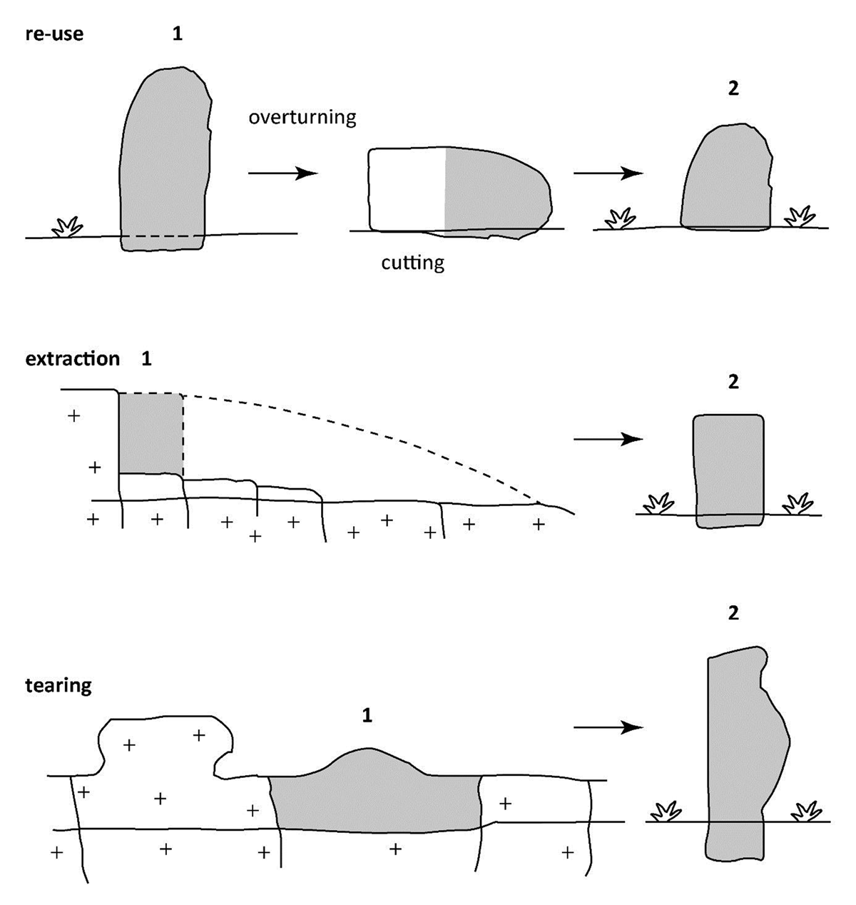
Figure 1
The terms of supply in megalithic monoliths and the consequent traces of pre-megalithic erosion found on the derived standing stone. Modified from Sellier (2013: 16).
Surface exposure dating
The topmost surface of the Velmaio boulder was sampled for surface exposure dating. Not enough pure quartz was obtained for 10Be sample preparation, therefore, we used 36Cl. Whole rock sample preparation, followed the method of Stone et al. (1996), as modified by Ivy-Ochs (1996), Ivy-Ochs et al. (2004) and recently summarized by Groos et al. (2021). The crushed rock sample was sieved to <0.4 mm. After leaching, the sample was dissolved with HF and HNO3. Cl was precipitated with addition of AgNO3. After redissolution, S was separated with addition of Ba(NO3)2. AgCl was precipitated dried and pressed into Ta target holders for AMS measurement. 36Cl/Cl ratios were measured at the 6 MV Tandem system at the Laboratory of Ion Beam Physics. Sample ratios were measured against the K382/4 N house standard with a nominal ratio of 17.36 × 10⁻¹². The ETH house standard has been normalized against KNSTD 5000 (Synal et al. 1997; Christl et al. 2013; Vockenhuber et al. 2019). Measured sample ratios were corrected for full process blanks of 4.0 × 10⁻¹⁵. Major and trace elements as required for age calculation were determined commercially run by Actlabs (Ontario, Canada).
To calculate the 36Cl exposure age we used an in-house MATLAB code with the constants and equations given in Alfimov & Ivy-Ochs (2009). We implemented the following spallation production rates: 48.8 ± 3.4 at gCa a-1 (Stone et al. 1996), 162 ± 24 at gK a-1 (Evans et al. 1997), 13 ± 3 at gTi a-1 (Fink et al. 2000), and 1.9 ± 0.2 at gFe a-1 (Stone et al. 2005) and the scaling scheme of Stone (2000). A neutron flux value of 760 n gair a-1 is used to account for (epi)thermal neutron capture on 35Cl (Alfimov & Ivy-Ochs 2009; and references therein). Muon treatment is as described in Alfimov & Ivy-Ochs (2009). The used production rates are in good agreement with those recently published in geologic calibration studies (Borchers et al. 2016; Marrero et al. 2016).
Results
Geographical and geological context
The standing stone of Velmaio is located in the Municipality of Arcisate (Provincia di Varese, Regione Lombardia, Italy). The boulder is located at the coordinates 2,712,020/1,076,470 (CH1903+/LV95) or 45°49’50”N, 8°52’48”E (WGS 84), at an altitude of 322.7 m a.s.l., on the valley bottom of the Torrente Bévera (Figure 2A). The Torrente Bévera flows from Piamo Inferiore (Viggiù, Varese) to the confluence with Fiume Olona in Malnate (Varese), which is a tributary of the Lambro River.
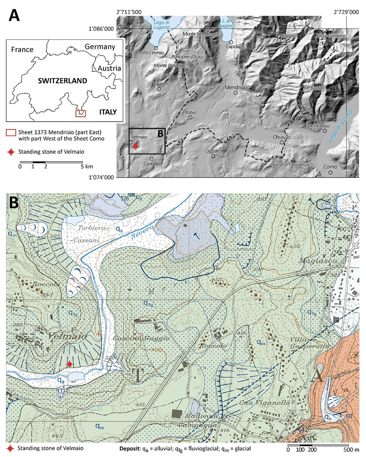
Figure 2
Geographical and geological context of the Velmaio standing stone. A: General location and extension of Sheet 152 of the Geological Atlas of Switzerland 1:25,000 (GA25, see: Bernoulli et al. 2017). B: Detail from GA25 showing the location of the standing stone and the surrounding Quaternary deposits. The entire Sheet of the GA25 and the complete legend are available on the mapping platform of the Swiss Confederation: https://map.geo.admin.ch Data and sources: A: Hillshade based on the digital elevation models swissALTI3D (©Swiss Federal Office of Topography swisstopo) and DTM 5 × 5 (ed. 2015) of the Lombardy Region (©Regione Lombardia); B: ©Swiss Federal Office of Topography swisstopo. Coordinates are in the system CH1903+ / LV95.
The boulder is placed in the distal part of an alluvial fan (2 m above the river bed of the Torrente Bévera), at the point where the slope change hints at the presence of a poorly marked terrace (Figure 3A). The alluvial fan is composed of glacial outwash and resedimented till (IT: Deposito di dilavamento glaciale; DE: Verschwemmte Moräne) of the Late Pleistocene (Bernoulli et al. 2017; Bernoulli et al. 2018). This kind of deposit is typical of alluvial fans formed by the runoff of the fine-grained fraction of glacial and fluvioglacial deposits preceding the LGM and occurs on main valley floors that were not covered by glaciers during the LGM. The fine-grained fraction was reworked from glacial deposits deposited prior to the LGM, forming a moraine ridge in the locality of Roccolo (443 m a.s.l.), north of Velmaio (392 m a.s.l.), and from pre-LGM fluvioglacial deposits, which form the steep part of the slope between the Torrente Bévera floodplain and the village of Velmaio (Bernoulli et al. 2017; Figure 2B).
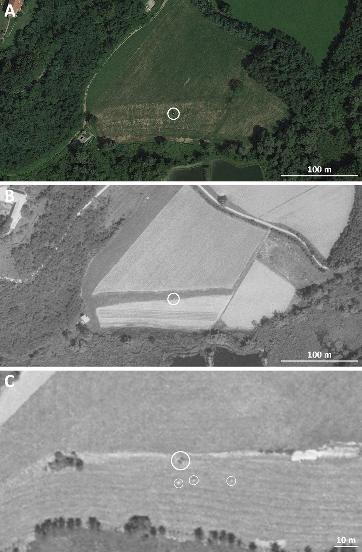
Figure 3
Aerial photographs of the Velmaio standing stone (main circle). A: Google Earth image of the 14 August 2021. B: LUBIS image 19770770014364 of the 16 June 1977. C: LUBIS image 19450320090098 of the 15 June 1945. The standing stone can be recognized by its shadow (large circle). Three other smaller boulders appear to be present to the south and south-east of the Velmaio standing stone. Sources: A: ©Google Earth; B: ©Swiss Federal Office of Topography swisstopo.
The standing stone of Velmaio is enclosed by a sort of ring of markedly smaller stones (20 to 40 cm in diameter), located at a distance of 50 to 100 cm from its base (Pirondini et al. 2016). It represents the only metre-sized boulder on the alluvial fan since at least 1977 (see the aerial photograph in Figure 3B). Indeed, in a previous aerial photograph of 1945, three more smaller boulders appear to be present to the south and southeast of the standing stone, at a distance between 10 and 25 m (Figure 3C).
An erratic boulder is located north-east of the standing stone, between Velmaio and Cascina Gaggio (coord. CH1903+/LV95: 2,712,260, 1,076,715; coord. WGS 84: 45°49’58”N, 8°52’60”E; 324.9 m a.s.l.; see Figure 2B), on pre-LGM glacial deposits (Bernoulli et al. 2017; Monegato et al. 2022).
Morphological analysis
The Velmaio standing stone is 3.30 m high and 2.60 m wide and is currently in a vertical position. By its dimensions, it can be characterised as a boulder. The morphological and traces descriptions were realised face-by-face according with their orientation.
–North-western face (Figure 4A): because of its size, it is the major one of the boulder. Its shape is rectangular at the base and then narrows towards the top. This face presents numerous multi-centimetric to decimetric rock inclusions, giving it a pronounced aesthetic appearance. At the top of this face, traces of pre-megalithic erosion are visible, notably with erosion pits. This face must therefore have been in a horizontal and upper position in the past.
–Southwestern face (Figure 4B): it is interpreted to be a weathered face that was exposed to erosion, but less intensively than the north-western face and perhaps not in a top position.
–Southeastern face (Figure 4C): it could be interpreted as a fresh face that was in contact with the bedrock. The absence of sharp edges and of traces of quarrying at the intersection between the southeastern fresh face and the south-western weathered face, however, does not allow to confirm this hypothesis.
–North face (Figure 4D): with its very smooth appearance and the lack of visibility on the inclusions, could be interpreted as a diaclase face.
–Top face: the top of the boulder shows no obvious post-megalithic erosion. The particular lithology of this boulder (see below) may react very little to erosion by the flow of water from the top onto the faces. The top face was sampled for 36Cl exposure dating (Figure 4D).
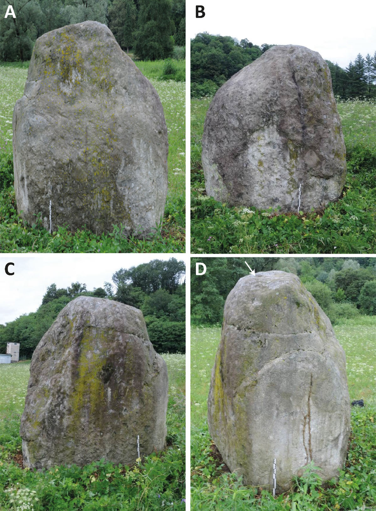
Figure 4
Photographs of the four faces of the Velmaio standing stone. A: north-western face; B: south-western face; C: south-eastern face; D: north face. The arrow indicates the sampling point for 26Cl surface exposure dating. Photos: F. Cousseau, 15 July 2019.
The morphological analysis and its interpretation allow us to conclude that the boulder is not in its original position. However, as no traces of quarrying or shaping are visible on the five faces, it is not possible to confirm by the study of the faces of the monolith that the boulder was displaced by humans.
Evidence such as the pre-megalithic erosion on the north-western face and the position of the block, indicates that it was erected by human activity. Even if the faces were smoothed by erosion, as indicated by the absence of sharp edges at the intersection between the southwestern and the southeastern faces, it is possible to recognise two weathered faces (north-western and southwestern faces) and an original fresh face (southeastern face), that was once in contact with the original bedrock. Because of this we propose a reconstruction of the original position of the boulder in contact with the bedrock (Figure 5). Our analysis also confirms that the boulder has been extensively smoothed by erosion, probably glacial, after being detached from the bedrock.
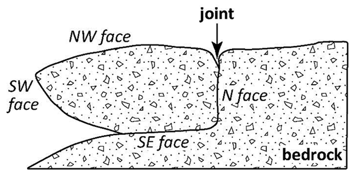
Figure 5
Proposal of restoring the original position of the boulder attached to its bedrock.
Our morphological analysis shows that no traces of human action have been left on the monolith. This supports the idea that the block must have been exhumed by forces of nature from the bedrock. A glacial event should be the cause, as some of the marks on the faces of the block are glacial striations and not engravings as has been proposed by Pirondini et al. (2016). In Indonesia today, blocks are still quarried, moved over long distances with ropes and logs and put together to build dolmens (Steimer-Herbet 2018). Observations on these displaced monoliths show that transport does not leave necessarily specific traces on their surface. Therefore, the absence of marks does not preclude anthropic transport and erection of the Velmaio stone. At this stage, from an archaeological point of view, only excavations at the foot of the boulder could confirm human activity by identification of a socket hole that might contain datable artefacts.
Lithology of the standing stone
The standing stone of Velmaio is a block composed of a dolomite breccia. The breccia is unsorted and shows no bedding; the angular to subangular clasts are closely packed and range from granule to cobble-sized gravel; they show long and locally sutured contacts. Most of the clasts are structureless dolomite, some with a stromatolitic structure or distinctly laminated (Figure 6C), in addition cm-sized clasts of lilac to pink rhyolite occur Figure 6A). The facies of the dolomite clasts match those of the Middle Triassic San Salvatore Dolomite of the western Southern Alps (Bernoulli et al. 2018), the clasts of the pink rhyolites are obviously derived from the Lower Permian volcanic succession of the same area. The ‘overpacked’ clasts that were welded by pressure-solution, show that the sediment was compacted by overburden or during the Alpine orogeny.
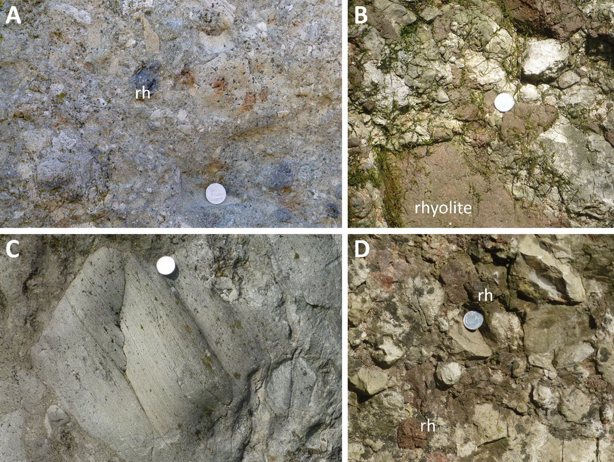
Figure 6
Lithologies of the standing stone of Velmaio and of the Invorio Breccia near Invorio superiore. A and C: Lithology of the boulder of Invorio Breccia at Velmaio. A: Clast-supported breccia with closely packed angular to subangular clasts of San Salvatore Dolomite (Middle Triassic) and subordinate clasts of Permian rhyolite (rh). C: Clast of laminated dolomite. B and D: Invorio Breccia (presumably Lower Jurassic) near Invorio superiore: clast-supported breccia with closely packed, angular to subangular clasts of San Salvatore Dolomite and Permian rhyolite (rh). Diameter of coins is 20 mm. Photos: D. Bernoulli, 22 March 2013 (A and C) and 31 March 2017 (B and D).
Lithologies that could be compared to that of the standing stone are not known from outcrops in the surroundings or up-valley of Velmaio, but from west of Lago Maggiore. The texture and, in particular, the composition of the breccia corresponds to that of the Invorio Breccia outcropping some 30 km southwest of Velmaio. The Invorio Breccia crops out in the valley of the Torrente Vevera east of the village of Invorio Superiore (Casati 1978). The outcrop east of the Vevera has been largely destroyed by the construction of the Autostrada A26 but the western outcrop still exists (Casati 1978: 321). The composition of the Invorio Breccia compares well with that of the standing stone; the tightly cemented cm- to dm-sized components are crystalline dolomites, stromatolitic dolomites and dolomites with traces of dasyclad algae, rhyolitic volcanic rocks, and minor fragments of metamorphic basement rocks (Figures 6B, 6D). The dolomite clasts are obviously derived from the Middle Triassic San Salvatore Dolomite, the rhyolites from Permian volcanic succession underlying the dolomite. As in the case of the standing stone, there are no sedimentary structures that would provide clues for the depositional environment of the Invorio Breccia.
The outcrops of the Invorio Breccia are isolated and the contact to under- or overlying formations is not exposed. However, all authors (Casati 1978; Berra al. 2009; Decarlis et al. 2017) suggest an Early Jurassic age for the breccia and a close relationship to the rifting of the continental crust that affected the future area of the Southern Alps at that time (e.g. Bertotti et al. 1993; Berra et al. 2009). During the Early Jurassic phases of rifting, the area west of Lago Maggiore formed a structural high where Permian volcanic rocks and Middle Triassic sediments were sub-aerially were exposed (Berra et al. 2009; Decarlis et al. 2017). The Invorio Breccia is certainly related to this phase of rifting; its deposition in a subaerial environment is probable (Casati 1978; Berra et al. 2009; Decarlis et al. 2017); however, deposition near a submarine fault scarp cannot be exclude a priori. The area east of Lago Maggiore shows a different palaeotectonic evolution (Kälin & Trümpy 1977) that excludes an origin of the standing stone from the bedrock of this area.
Surface exposure dating
The36Cl exposure dating results for the Velmaio boulder are given in Table 1, with major and trace element concentrations as required for age calculation listed in Table 2. The analysed Velmaio boulder sample contains 0.6787 ± 0.0280 36Cl atoms grock-1. The natural Cl concentration is 26.62 ± 0.18 ppm. We calculated a 36Cl exposure age of 89.72 ± 5.10 ka with no correction for weathering and 89.42 ± 5.47 ka using a boulder surface weathering rate of 1 mm ka-1 (André 2002). For discussion purposes we use the non-erosion corrected age.
Table 1
36Cl exposure dating results for the Velmaio standing stone. AMS blank value used 4.0 × 10⁻¹⁴.
| SAMPLE NAME | VELMAIO | |
|---|---|---|
| Latitude | XX.XXXX | 45.8308 |
| Longitude | XX.XXXX | 8.8803 |
| Elevation | (m a.s.l.) | 323 |
| Thickness | (cm) | 2 |
| Topographic shielding | 0.9963 | |
| 36Cl | 106 at/grock | 0.6787 ± 0.0280 |
| Exposure age no erosion | (ka) | 89.72 ± 5.10 |
| Exposure age with an erosion rate of 1 mm ka-1 | (ka) | 89.42 ± 5.47 |
Table 2
Major and trace element concentrations required for exposure age calculation of the Velmaio standing stone. *AMS measured.
| SAMPLE NAME | VELMAIO | |
|---|---|---|
| Al2O3 | (%) | 13.85 |
| CaO | (%) | 1.00 |
| Fe2O3 | (%) | 3.13 |
| K2O | (%) | 3.47 |
| MgO | (%) | 1.04 |
| MnO | (%) | 0.048 |
| Na2O | (%) | 2.98 |
| P2O5 | (%) | 0.02 |
| SiO2 | (%) | 70.83 |
| TiO2 | (ppm) | 0.27 |
| Sm | (ppm) | 1.8 |
| Gd | (ppm) | 1.5 |
| U | (ppm) | 3.5 |
| Th | (ppm) | 10.2 |
| Cl* | (ppm) | 26.62 ± 0.18 |
Discussion
An erratic boulder from MIS6?
The 36Cl exposure age of 89.72 ± 5.10 ka, the smooth surface of the standing stone and the absence of clear traces of human quarrying suggest that the Velmaio boulder does not stem directly from autochthonous bedrock, but in turn is derived from Pleistocene deposits. The location of the standing stone on pre-LGM Quaternary deposits and the exposure age point to exhumation of the boulder likely from glacial deposits, certainly before the LGM (Marine Isotope Stage MIS2). Considering that during all of the Last Glacial Period the extent of glaciers was not greater than that reached during the LGM, the exhumation and original deposition of the boulder probably predates MIS 3, 4 and 5 (see Figure 7).
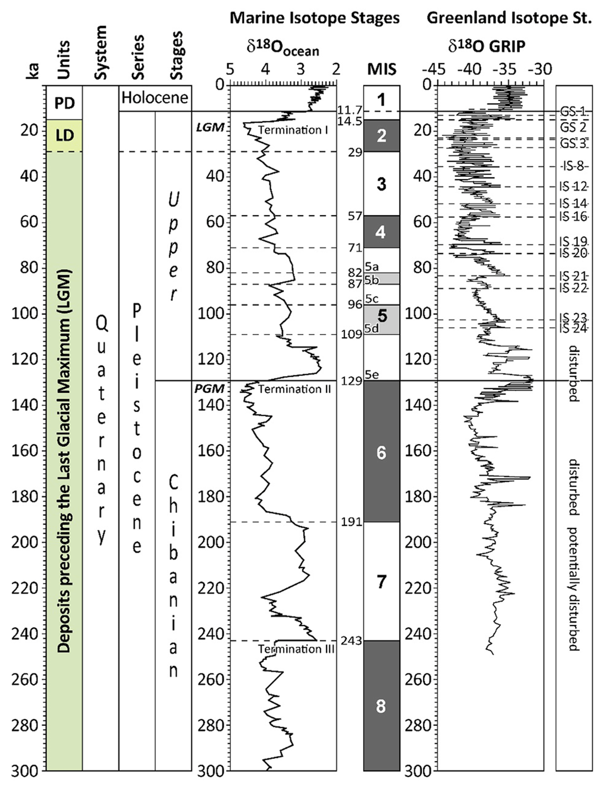
Figure 7
Chronostratigraphical units defined in the South-Alpine area (“Units”) and correlation with the Quaternary stratigraphy (Cohen & Gibbard 2022), the marine isotope stratigraphy (McManus et al. 1999; Lisiecki & Raymo 2005) and the Greenland isotope stratigraphy (Dansgaard et al. 1993) for the last 300 ka. LD = Last Glacial Maximum Deposits; LGM = Last Glacial Maximum; MIS = Marine Isotope Stage; GRIP = Greenland Ice Core Project; GS = Greenland Stadial; IS = Greenland Interstadial; PD = Postglacial Deposits; PGM = Penultimate Glacial Maximum. Modified from Bernoulli et al. (2018: 21).
Cosmogenic nuclides build-up in minerals exposed to cosmic rays (Dunai 2010). If completely exposed (no overlying rock or sediment cover), an exposure age measures how long the boulder was standing in that position. If partial cover or reorientation of the boulder occurs, then the determined age is a strict minimum age. The actual time of deposition can have been much earlier than the calculated age. Therefore, our determined age is a minimum age for original deposition of the boulder in a pre-LGM glacial or related deposit (cf. Putkonen & Swanson 2003; Briner et al. 2005; Heyman et al. 2011). One possibility is that glacial plucking and original deposition of the Velmaio boulder took place during the Penultimate glaciation (MIS 6 in Figure 7), perhaps during the Penultimate Glacial Maximum (PGM) at around 140 ka (Colleoni et al. 2016), when glaciers were significantly larger than they were during the LGM (Monegato et al. 2023). Nevertheless, deposition at an earlier time cannot be strictly ruled out, especially considering the likelihood of a change not only in location but in orientation of the boulder.
Four other pre-LGM exposure ages have been obtained from erratic boulders of the Toce-Ticino glacier system and are possibly related to glacier expansion during MIS 6 (Kamleitner et al. 2022). The dated boulders are located on the west side of Lago Maggiore in Mottarone-Stresa (VR19) and in Alpe Canà, above Brovello-Carpugnino (VR30, VR42, VR45) (Figure 8). 10Be exposure ages calculated with 1 mm ka–1 erosion for these four boulders are 70.3 ± 3.6 ka for VR19 on the slope in Mottarone-Stresa, 101.9 ± 2.7 ka for VR30 on ridge 1–2 on the slope in Alpe Canà, 74.9 ± 1.6 ka for VR42 on the external slope in Alpe Canà, and 78.3 ± 2.0 ka for VR45 on the slope south of Alpe Canà (Kamleitner et al. 2022).
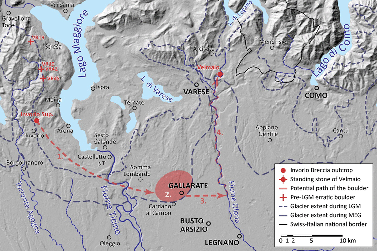
Figure 8
Potential migration of the Velmaio boulder from the outcrop of the Invorio Breccia in Invorio Superiore to the place of final emplacement on the shore of the Torrente Bévera in Velmaio. 1. Glacial transportation during the PGM from Invorio Superiore to the potential zone of deposition as an erratic boulder in (2.) in the most downstream position possible. 3. Anthropic displacement from the zone of glacial deposition to the Fiume Olona. 4. Transportation on the Fiume Olona and Torrente Bévera up to Velmaio. Base map of the Common Information Platform for Natural Hazards (Swiss Federal Office for the Environment FOEN and European Environment Agency EEA). Glacier extent during the Last Glacial Maximum (LGM) from Kamleitner et al. (2022), and Monegato et al. (2022) for the Ticino-Toce glacier system and from Bini et al. (2009) for the Ticino-Adda and Adda glacier systems. Glacier extent during the Most Extensive Glaciation (MEG) reconstructed on the basis of the morainic amphitheatres and data of Bini et al. (1996). VR19, VR 30, VR42 and VR45: pre-LGM erratic boulders dated with 10Be by Kamleitner et al. (2022).
An origin of the Velmaio boulder from north of its present location is excluded, because of the lack of outcrops of the Invorio Breccia to the north. Outcrops of the Invorio Breccia are restricted to west of Lago Maggiore and at present only found at Invorio Superiore (Figure 8). It is probable that the boulder was first glacially plucked at this locality, located ca. 31 km west-southwest of Velmaio.
Assuming that the ice conveyor belts during previous glaciations were similar to those reconstructed for the LGM for the Toce-Ticino glacier system (Monegato et al. 2022), it is highly unlikely that the Velmaio boulder arrived at its present site by glacial transport alone. It must therefore be assumed that the boulder was eroded from the bedrock and transported by the glacier, perhaps during MIS6, to an intermediate position. Only during a second time, was it transported by Man to its current location, where it was then placed in a vertical position.
From Invorio Superiore, the boulder could only have been transported to the south as far as the Ticino-Toce glacier system during a much more extensive Middle Pleistocene Glaciation, i.e. at most to Cardano al Campo, Province of Varese (Bini et al. 1996), situated ca. 22 km to the south-southwest of Velmaio (Figure 8).
In any case, it is difficult to assume that the Velmaio boulder was redeposited more to the east than Cardano al Campo or Gallarate, even taking into account that erratic boulders were transported from the west of Lago Maggiore to the east as testified by some boulders derived from the Toce Valley (Monegato et al. 2022). Although erratic boulders may migrate from one side of a glacier to the other, as was the case for example of the Valais glacier during LGM (Jouvet et al. 2017), and although we do not know the flow lines in the Lago Maggiore amphitheatre during pre-LGM glaciations, the boulder of Velmaio could hardly have been transported by ice to its present location. The most easterly location the boulder could have reached by glacial transport would be about 10 km from the lower reaches of the River Olona, from where the stone might have transported by Man upvalley to Velmaio (Figure 8).
Megaliths in the Verbano and Ceresio areas
The use of large stones in constructions with a social, religious, and funerary vocation is called megalithism (Gallay 2010). There are two major categories of monuments: menhirs (isolated or not), which are monolithic megaliths with stones placed in a vertical position; and dolmens, polylithic megaliths with the function of collective graves.
Megalithism in Switzerland and surrounding regions appeared in the Middle Neolithic, probably during the 5th millennium BCE (Gallay 2010). The first megalithic funerary constructions, however, did not develop until the middle of the 4th millennium BCE and are widespread only from the beginning of the 3rd millennium BCE (Gallay 2010). The necropolis of Sion-Petit-Chasseur in the Canton du Valais (Switzerland) was used from the beginning of the 3rd millennium until the end of the Early Bronze Age, ca. 1600 BCE (Besse & Piguet 2011).
In the recently discovered megalithic site of Claro (Cantone Ticino, Switzerland), several phases of occupation are documented, of which two are characterised by megalithism (Federici-Schenardi & Gillioz 2020; Federici-Schenardi & Gillioz 2021; Federici-Schenardi & Gillioz 2022; Biaggio-Simona 2023). The three oldest phases were attributed to the Copper Age or Chalcolithic (3400–2200 BCE). These are characterised by: a first phase with four large menhirs (up to a length of 3.5 m and a weight of 21 t), in some cases including the socket hole (2800–2500 BCE?); a second phase with small menhirs (20–60 cm) positioned or in pits with crowning stones or resting directly on the ground (2500–2300 BCE); and a third phase characterised by the reworking and displacement of some menhirs. The large menhirs of the first phase do not bear traces of human working that was described on the stones of the housing pit. Traces of shaping of the boulders were on the contrary described on the small menhirs of the second phase, which constitute the first attestation in Ticino of stone quarrying and working. It is interesting to note that the four large menhirs of the first phase are all of mesocratic gneiss, predominantly biotite augengneiss, of the Simano unit (F. Schenker, D. Czerski and C. Scapozza, unpublished data), not outcropping in the close surroundings of Claro but only in the upper part of the valley slope above the village (Schenker & Scapozza 2023). In the area of Claro, the dominant lithology is inhomogeneous two-mica granitic gneiss with a variable texture (lower part of the slope) and two-mica granitic gneiss with homogeneous not differentiated texture (middle part of the slope), both belonging to the Leventina unit (Schenker & Scapozza 2023). In the massive, clast-supported cobbles and/or gravel described in the alluvial fan of Claro (see Czerski et al. 2022), 78% of the clasts are gneiss of the Leventina unit and 22% of the clasts are gneiss of the Simano unit (C. Scapozza and D. Giacomazzi, unpublished data). If the stones of the housing pit of the large menhirs of the first phase and the small menhirs of the second phase present different lithologies, with a predominance of gneiss of the Leventina unit, the large menhirs of the first phase were probably selected because they consist exclusively of augengneiss of the Simano unit.
The face-by-face morphological analysis of the Velmaio standing stone suggests that the boulder was placed in an upright position after a considerable lapse of time after exhumation from the bedrock. However, in the absence of an archaeological analysis of the context and of the ground below the boulder, it is not possible to correlate the installation of the standing stone directly with the cultural chronology. That being said, we may assume that the boulder was possibly selected because of its very particular lithology, which is not present in the surrounding area and crops out only in a very limited site located ca. 31 km to the west-southwest of Velmaio. It is clear that a chronological correlation between Velmaio and Claro based exclusively on the selection of the material is hazardous. Nevertheless, considering the great size of the megalith, the absence of human-made traces on the stones and the strict archaeological/cultural relationships and the material exchanges between the lower and the upper parts of the Lago Maggiore basin (e.g. Ostinelli & Chiesi 2015; AA.VV. 2019; Zanco et al. 2021), we propose that the erection of the Velmaio stone possibly took place during the 3rd millennium BCE.
Conclusions
Four main conclusions can be drawn from the observations and analyses of the standing stone of Velmaio.
Our geoarchaeological analysis of the megalith indicates that the boulder is not in its original position and its secondary vertical position is confirmed by traces of pre-megalithic erosion. However, the absence of post-megalithic traces excludes quarrying and/or an anthropic intervention on the shape of the boulder.
The monolith consists of a dolomite breccia that can, by its specific lithology, be correlated with the Invorio Breccia that today crops out exclusively near Invorio, west of the Lago Maggiore, some 30 km southwest of Velmaio, and is not known up-valley of its present site. As the area east of Lago Maggiore shows a different palaeotectonic and stratigraphical evolution than the tectonic unit at Invorio, an origin of the Velmaio standing stone from the area east of Lago Maggiore can be excluded.
Surface exposure dating of 89.72 ± 5.1 ka of the standing stone, as well as the smooth surface and the absence of traces of human reworking, suggest that the Velmaio boulder was most probably exhumed from Pleistocene deposits. The interpretation of the surface exposure dating as a minimum age of exhumation point to glacial redeposition prior to MIS 3, 4 and 5, perhaps during MIS 6 in correspondence with the Penultimate glaciation, in particular during the PGM occurring at around 140 ka.
By correlation with documented megalithism in Switzerland and northern Italy, and by typological comparison with recently discovered megaliths at Claro (Cantone Ticino, Switzerland), we may assume that the Velmaio standing stone was probably selected because of its very peculiar (and unique) lithology. It was subsequently transported, from the locality of glacial deposition and following exhumation, to the place of erection, perhaps during the 3rd millennium BCE.
Data Accessibility Statements
All relevant data are included in the article.
Acknowledgements
A special thanks to Dorota Czerski, Daphné Giacomazzi, Filippo Schenker and Linda Soma for their fieldwork contribution. We acknowledge the Service of Archaeology, Ufficio dei beni culturali of Cantone Ticino, for information and collaboration concerning the megalithic site of Claro; particular thanks to Maruska Federici-Schenardi, Mattia Gillioz, Rossana Cardani Vergani and Simonetta Biaggio-Simona.
Competing Interests
The authors have no competing interests to declare.
Author contributions
Investigation and formal analysis were done by all the authors. Conceptualization was developed by CS, CA, SIO, and DB; Methodology and writing the original draft were done by CS, FC, SIO, and DB. Writing, reviewing, and editing was done by CS, FC, SIO, and DB.