
(1) Overview
Context
Archaeological investigations over the past two centuries have identified megalithic sites across diverse landscapes of the Indian subcontinent, establishing the megalithic tradition as a major component of South Asian archaeology [1, 2, 3, 4, 5, 6, 7, 8, 9, 10, 11, 12, 13, 14, 15, 16, 17, 18, 19, 20, 21, 22, 23, 24, 25, 26, 27, 28, 29]. Megalithic traditions are not restricted to a single period. In Europe, they belong to the Neolithic, Chalcolithic and Bronze Age [30, 31, 32, 33, 34, 35, 36], and in South Asia megalithic monuments are known from Chalcolithic and Iron Age contexts [4, 14, 37, 38, 39]. In peninsular and central India, including the Vindhyan Plateau, the megalithic tradition is generally associated with Early Iron Age communities and continues into the Early Historic period [19, 21, 38, 40, 41, 42]. In India, archaeological investigations have been largely concentrated in peninsular India, where extensive excavations and regional surveys have shaped the prevailing understanding of the Indian megalithic tradition [2, 8, 9, 13, 26, 37, 43]. Consequently, the megalithic culture has long been regarded as a phenomenon primarily associated with southern India. This perception has changed considerably over the last four decades following systematic archaeological investigations in the Vindhyan region. More than 200 megalithic cemetery and habitation sites have been documented from different parts of the Vindhyan Plateau, including Mirzapur, Sonbhadra, Prayagraj, Chandauli, Banda (Uttar Pradesh), Sasaram (Bihar), and Rewa (Madhya Pradesh) [6, 11, 14, 15, 17, 44, 45, 46]. These discoveries show that the Vindhyan region represents an important northern distribution of the South Asian megalithic tradition and exhibits considerable diversity in monument types, settlement organisation, and landscape use.
Archaeological datasets play an important role in preserving primary field observations and facilitating their reuse in future research. Standardised digital datasets enable comparative regional studies, spatial modelling, heritage management, and long-term monitoring of archaeological landscapes. Several digital archaeological initiatives in South Asia provide broader frameworks for archaeological documentation and dissemination. The Mapping Archaeological Heritage in South Asia (MAHSA) project develops an open-access geospatial database of archaeological and cultural heritage, while the Historical Atlas of South India v.1.0 provides a GIS-based platform for archaeological and historical information from prehistoric to historical periods [47, 48]. These initiatives operate largely at the level of sites or regional heritage inventories, and the Atlas is centred on South India. The present dataset complements them by providing a monument-level geospatial record of the megalithic landscape of the Adwa River Valley, for which no comparable dataset was previously available. It links cemetery and habitation sites with their spatial, typological, environmental and preservation attributes and is intended as a reusable resource for future research.
The Adwa River Valley preserves one of the major concentrations of megalithic sites in the northeastern Vindhyan Plateau (Figures 1 & 2). The Adwa Valley is located in the south-eastern part of the Rewa district of Madhya Pradesh, India. The valley extends for approximately 50 km between the Kaimur and Rewa hill ranges, with its width varying from about 1.2 to 4 km. The Adwa River flows west to east through the valley before turning northeast and joining the Belan River. The valley presents a varied landscape of hill slopes, flat hill-tops and relatively level valley floors, with elevation ranging from approximately 212 m to 542 m above mean sea level, and the valley floor generally sloping from west to east. The geological setting belongs mainly to the Upper Vindhyan formations, with sandstone, shale, orthoquartzite, and limestone widely distributed across the region [49]; sandstone is particularly important as a locally available lithic resource. The valley receives approximately 1,200–1,400 mm of annual rainfall [50] and contains soil groups including ferric luvisols and chromic vertisols that provide relatively suitable conditions for cultivation, particularly across relatively level and alluvial surfaces [51, 52].
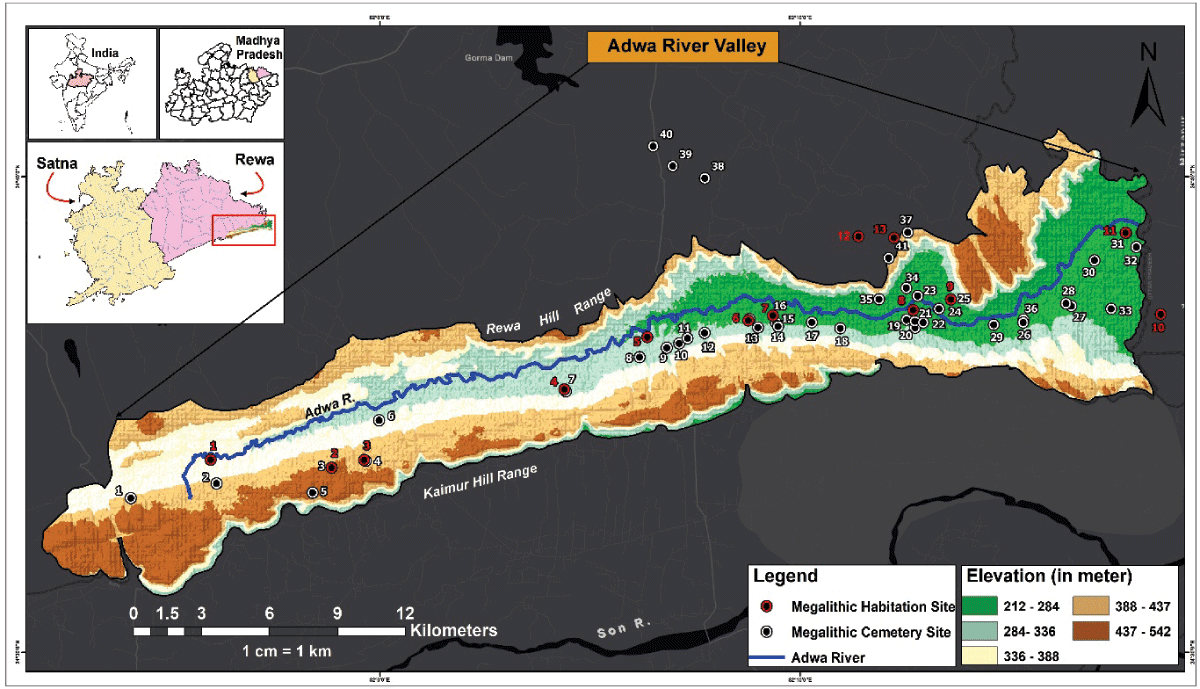
Figure 1
Spatial distribution of 41 megalithic cemetery sites and 13 habitation sites in the Adwa River Valley, Vindhyan Plateau, India (Blank areas: no remains recorded; see Survey coverage and interpretation of gaps).
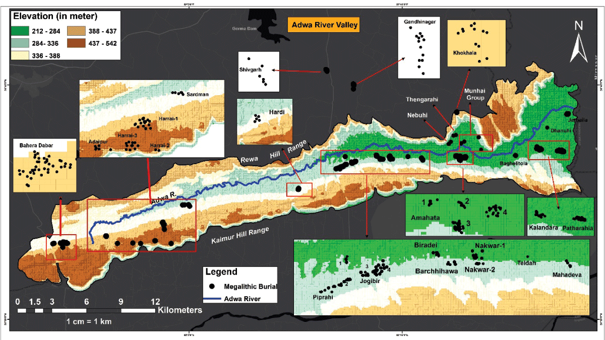
Figure 2
Spatial distribution and clustering of 493 megalithic burial monuments documented from 41 cemetery sites in the Adwa River Valley (Blank areas: no remains recorded; see Survey coverage and interpretation of gaps).
The first systematic archaeological investigations in the valley were carried out by the University of Allahabad during the 1980s, which identified numerous cemetery and habitation sites and established the basic typological framework of the region’s megalithic culture [16, 29, 38, 53]. The available records, however, are primarily site-based, reporting the presence of megalithic monuments and their reported counts (often rounded) at individual sites rather than providing monument-by-monument documentation. They also lack standardised records of individual monument attributes and associated archaeological materials, while the geographic coordinates reported for some sites are inconsistent with their locations established during the present survey [38]. Thus, the earlier survey provides an important baseline for site identification and site-level monument counts (many of them rounded), but does not constitute a directly comparable monument-level dataset.
The present investigation (2021–2026) revisited the Adwa valley and systematically recorded individual monuments and their spatial, architectural, and preservation attributes, thereby contributing to the understanding of the distribution, diversity and landscape context of the megalithic tradition of the Adwa River Valley.
Spatial Coverage
Description: Adwa River valley, Rewa district, Madhya Pradesh, India
Northern boundary: 24°38’38.49”N, 82° 7’26.83”E
Southern boundary: 24°34’52.42”N, 82° 8’1.37”E
Eastern boundary: 24°38’18.98”N, 82°18’7.77”E
Western boundary: 24°32’4.49”N, 81°52’2.91”E
Temporal Coverage
One of the excavated megalithic burials at Kotia yielded a radiocarbon date of 2200 ± 150 BP from a carbon sample. Based on this date, together with the wider distribution of megalithic burials in the Vindhyan region and their typological similarity to megaliths of central India, the chronology of the Vindhyan megalithic tradition can be broadly placed between 800 BCE and 300 BCE [38, 54, 55]. The proposed chronology is based on pottery and other material remains collected from the habitation sites and on comparison with excavated and dated megalithic sites from other parts of South Asia [24, 9, 14, 28, 37, 38, 42, 56, 57, 58, 59, 60].
(2) Methods
Steps
The evidence of megalithic culture in the study area is present in two forms: megalithic cemetery sites and megalithic habitation sites. The documentation of these sites constitutes a major component of the research. The present study followed a three-stage methodology, designed to document the megalithic remains of the Adwa River Valley in a systematic and standardised manner. These stages included: (i) documentation of megaliths at the cemetery sites to understand their typology, physical attributes, and preservation status; (ii) documentation of megalithic habitation sites through the cross-transect method to understand settlement nature, mound extent, and associated material remains; and (iii) spatial analysis of all recorded data using GIS to examine distribution patterns and land use.
Documentation of Megaliths in Cemetery Sites
Each megalithic cemetery site was first visited in person to assess the number, condition, and layout of the surviving structures. Every megalith was then assigned a unique identification number, marked directly on or near the structure using permanent paint to ensure it could be easily located and referenced in future work. The precise location of each structure was physically recorded from its central point using the Geo-Tracker application, along with its elevation above mean sea level. Physical attributes were then measured in the field: diameter using a measuring tape, average stone size, depth of the surface deposit using a spirit level, and structural orientation using a compass. Each structure was photographed from multiple angles with a mirrorless camera, and a 1–5 cm scale was placed alongside any associated material remains before they were collected and stored in labelled sample bags.
All observations were recorded on a standardised Megalithic Documentation Sheet (MDS), which included fields for structure number, location relative to nearby burials, type, coordinates, altitude, diameter, deposit depth, orientation, stone size, condition, associated materials, and general remarks. This field data was later compiled into a digital database.
The identification and classification of megalithic monuments in the present dataset were undertaken primarily through surface survey and based on their visible architectural and morphological characteristics. The classification therefore reflects the monument form visible at the time of survey rather than a determination based on subsurface excavation. Features such as the arrangement and extent of cairns, visible structural elements, and exposed cist components were used to distinguish the recorded monument types. However, the visibility of these features may be affected by vegetation, soil accumulation, erosion, stone displacement, collapse, and other surface processes. Consequently, concealed architectural elements may not be detectable during surface survey, and excavation or future investigation may reveal structural features that modify the present classification. To reflect this limitation, each record carries a classification-basis field (A = cist chamber/slabs directly visible or displaced cist slabs identifiable near the burial; B = no cist chamber or identifiable cist slabs visible, type = cairn). Types should be read as surface-based classifications, subject to revision when excavation or other evidence becomes available.
Documentation of Habitation Sites
Megalithic habitation mounds were documented using the cross-transect method. The centre of each mound was first identified based on surface spread and topography, and transect lines were laid out from this point in different directions, mainly north–south and east–west. Transect points were recorded at regular intervals (typically 5–50 m, depending on mound size) using a handheld GPS/Geo-Tracker application (accuracy of ±5 m), and the area within a 5–10 m radius of each point was examined for surface remains. At each point, archaeological material such as pottery, terracotta objects, stone artefacts and iron slags was identified and recorded. Diagnostic surface materials were selectively collected, bagged, and labelled with site name, transect number, and coordinates to preserve spatial context. This method enabled systematic assessment of mound extent, material density, and distribution, helping to distinguish core habitation zones from peripheral activity areas. All transect data were subsequently integrated into ArcGIS 10.8.2 for spatial analysis and distribution mapping.
Spatial Analysis
All spatial and attribute data collected from cemetery and habitation sites were compiled and analysed using ArcGIS 10.8.2. This allowed the distribution pattern of megalithic sites across the valley to be mapped and examined in relation to topographic and environmental variables. The analysis was also used to identify locational preferences of the sites and to interpret broader patterns of land use and landscape utilisation associated with the megalithic settlements.
Sampling Strategy
A total-coverage (non-probabilistic) strategy was adopted for megalithic cemetery sites, whereby every visible and physically accessible megalithic structure within each identified site was documented individually, rather than selecting a representative subset. This approach was chosen to ensure that the full range of structural variation, condition, and typology within each cemetery was captured.
Survey Coverage and Interpretation of Gaps
The entire study region shown on the maps (Area: 249 km²) was surveyed manually. The locations of sites were traced using previously published data and local inquiries. Previously reported megalithic sites were revisited and documented, and additional new sites were also identified during the present survey. Within each identified cemetery, all visible and accessible megalithic structures were documented. Areas where no megalithic remains were identified are therefore shown as areas without recorded archaeological remains. This does not necessarily mean that megalithic remains were never present. Vegetation, soil cover, erosion, agricultural activity, roads, canal and dam constructions and destruction may hide or remove surface remains. The survey therefore aimed at complete coverage of the study region; however, undetected remains cannot be excluded, and blank areas should be read as ‘no remains recorded’.
For habitation sites, an evenly spaced cross-transect sampling strategy was applied. Transect points were established in all directions from the mound centre at regular intervals, ensuring uniform spatial coverage across the mound surface. This design allowed the density and distribution of surface material to be assessed consistently across different sectors of each mound, rather than being biased toward areas of easier access or higher visible material concentration.
Quality Control
Several measures were taken to ensure the accuracy and reliability of the dataset. Each structure’s identification number, coordinates, and physical measurements were cross-checked against the corresponding field sketch map and photographic record at the time of documentation, to prevent duplication, omission, or misassignment of data. A subset of structures at each site was independently re-measured by a second team member to verify consistency of recorded dimensions. Geospatial coordinates obtained through the Geo-Tracker application were subsequently cross-validated against satellite imagery in Google Earth Pro to identify and correct any positional discrepancies. All completed field sheets were digitized promptly after each survey session and checked for internal consistency, including matching structure counts, coordinate ranges, and material labels, before being incorporated into the master database. Photographic records were reviewed alongside field notes to confirm that condition and typological classifications matched what was observed on-site.
Constraints
Many megalithic monuments in the study area have been disturbed by local villagers and stone quarrying activity, which has damaged or displaced the original stones. Because of this disturbance, morphological identification of structures was sometimes difficult, as their original shape and arrangement were no longer clearly visible. At some sites, the megalithic remains had been heavily destroyed, with only scattered stones surviving on the surface. Such sites could only be located on the basis of earlier reports, rather than through independent identification in the field.
(3) Dataset Description
Cemetery Site Dataset
This dataset contains records of 41 megalithic cemetery sites comprising 493 megalithic monuments.
Data Type
Primary data and processed data.
Format Names and Version
Microsoft Excel (.xlsx; 1. Megalithic_cemetery sites.xlsx, 2. Megalithic_Monuments.xlsx, 3. Comparative_chart.xlsx), Keyhole Markup Language (.kml; Megalithic_Cemetery Sites.kml, Megalithic_Monuments.kml), Figures, Graphs, Maps. All GIS data were created and analysed using ArcGIS 10.8.2 and Google Earth Pro software and shapefiles were downloaded from USGS Earth Explorer and BHUKOSH portal.
Dataset Description
The megalithic cemetery dataset is provided in five formats: Microsoft Excel (.xlsx), KML, maps, figures, and graphs. The Excel files contain the primary archaeological data, while the KML files, maps, figures, and graphs provide spatial and visual representations of the dataset. The first Excel file, Megalithic_Cemetery_Sites.xlsx, contains the names and geographic coordinates (latitude and longitude) of the 41 recorded megalithic cemetery sites in the Adwa River Valley. The second Excel file, Megalithic_Monuments.xlsx, contains detailed records of 493 megalithic monuments documented from these 41 cemetery sites. The recorded attributes include site name, monument number, monument type, geographic coordinates (latitude and longitude), altitude, monument diameter, depth of deposit from the present ground surface, orientation, average stone size, preservation condition, associated archaeological materials, and field remarks. For spatial analysis and mapping, the geographic coordinates were projected to the World Geodetic System 1984 Universal Transverse Mercator (WGS 1984 UTM) Zone 44N(EPSG:32644) coordinate reference system. The third Excel file, Comparative_Chart.xlsx, compares the number of megalithic monuments reported during the University of Allahabad survey in the 1980s with those recorded during the present field survey (2021–2026). This file provides information on the current preservation status of the megalithic monuments. The KML files display the locations of the cemetery sites and individual megalithic monuments on satellite imagery, allowing users to examine their spatial distribution in relation to topography, rivers, and the surrounding landscape. The maps illustrate the distribution of megalithic cemetery sites and the spatial clustering of monuments within the Adwa River Valley. The figures present the typological variation of the megalithic monuments, while the graphs summarize the main characteristics of the dataset through statistical visualization.
The dataset records two principal types of megalithic structures: cairns and cists within cairns. A cairn is a heap of loose stones with soil constructed over the surface and may or may not contain a cist within. The cist within a cairn consists of the cist, often at the centre of the cairn, and usually possesses a higher deposit than the cairn. Because the classification rests on surface evidence alone and no monument in the dataset was excavated by the present survey, concealed cists or chambers beneath the visible cairn deposit cannot be completely excluded.
A total of 493 megalithic monuments were documented from 41 cemetery sites, including 351 cairns and 142 cists within cairns. Cairns are the dominant monument type and represent approximately 71% of the recorded monuments, while cists within cairns account for the remaining 29%. Both monument types show considerable variation in their construction, size, and morphology. Based on field observations, cairns were classified into four subtypes according to the relative use of stone and soil in the mound construction, whereas cists within cairns were classified into four subtypes based on chamber construction and the arrangement of stone slabs. The typological classification of each monument is included in the dataset and is illustrated in the accompanying figures.
Previous excavations in the Adwa River Valley provide information on the cultural and funerary context of the megalithic monuments. Eight megaliths in the valley have been excavated, comprising four cairns and four cists within cairns [38, 61]. In the cairn megalith, an oblong gravel pit was dug into the natural soil down to the bedrock. The burial goods were then placed on this floor and subsequently covered with soil and stones. The cists within the cairn were more elaborate, starting with a circular pit dug from the ground surface and a rectangular chamber built near its centre. The cist was made of monolithic orthostats and covered with a capstone. Stone blocks and earth were packed around the orthostats to prevent them from collapsing outward. After the goods were deposited, the chamber was filled with earth, closed with the capstone and covered by a cairn. Ash and burnt clay lumps were reported from some burials [38]. The grave goods included pottery, microliths, ochre, copper fragments, stone pieces, stone discs, ring stones and burnt clay lumps. In some cists, the goods were placed at two levels within oval areas marked by stones. The pottery consisted of red ware, red and black-slipped ware, black-and-red ware and grey/black ware. Common forms were bowls, dishes, vases, funnel-shaped lids and pedestalled vessels. The lithic finds were microliths and short blades made on chalcedony, such as retouched blades, lunates and triangles. Animal remains, probably bovid, were found in some burials as fragmentary bones and may represent food offerings [38]. No human skeletal remains were reported from the excavated monuments, and none were observed during the present surface survey; the burial mode (primary/secondary) therefore cannot be established, and the monuments are referred to throughout as burial/memorial monuments. The database documents monument architecture and associated goods rather than anthropological data.
The dataset also records the present preservation condition of every documented megalithic monument. Each monument was assigned to one of three condition classes on the basis of visible surface evidence: intact (original stone arrangement visible, no obvious displacement or digging); partially disturbed (some stones displaced, removed or dug into, but the monument outline/type is still discernible); heavily disturbed (most stones displaced or removed, only scattered stones or a depression remain, and the original form can be inferred only partly). Of the 493 documented monuments, 128 are preserved in an intact condition, 240 are partially disturbed, and 125 are heavily disturbed. For heavily disturbed monuments, where the original architecture is partly visible, the type was assigned from the surviving features (displaced capstone or orthostats, a chamber depression, or the extent and arrangement of the cairn spread) and is flagged as basis B or C; these assignments are the least certain and should be treated with caution. Besides the eight monuments excavated earlier, 253 monuments show signs of informal digging or stone removal by villagers or quarrying; no monument was excavated during the present survey. These records provide the first systematic assessment of the preservation status of megalithic monuments in the Adwa River Valley and can be used to identify sites that require immediate conservation.
The dataset includes a comparison of the megalithic monuments from the cemetery sites randomly reported previously during the University of Allahabad survey in the 1980s. As the earlier survey provides site-level monument counts (many of them rounded) for individual cemetery sites rather than monument-level records, these site-wise counts were used as the basis for comparison with the present survey. The comparison is restricted to cemetery sites and megaliths documented during the earlier investigations and excludes newly identified sites (Table 1).
Table 1
Comparison of megalithic monuments documented during the Allahabad University survey (1980s) and the present field survey (2021–2026), showing the percentage decline in monument numbers.
| S. NO. | SITE NAME | MEGALITHIC MONUMENTS RECORDED (ALLAHABAD UNIVERSITY SURVEY, 1980s) | MEGALITHIC MONUMENTS RECORDED (PRESENT SURVEY, 2021–2026) | DECREASE IN MEGALITHIC MONUMENTS (%) |
|---|---|---|---|---|
| 1 | Bahera Dabar | 41 | 30 | 26.83 |
| 2 | Adaipura | 20 | 13 | 35 |
| 3 | Harrai | 60 | 30 | 50 |
| 4 | Sardman | 30 | 6 | 80 |
| 5 | Hardi | 100 | 20 | 80 |
| 6 | Piparahi | 20 | 6 | 70 |
| 7 | Jogibir | 90 | 57 | 36.67 |
| 8 | Biradei | 100 | 8 | 92 |
| 9 | Nakwar | 92 | 36 | 60.87 |
| 10 | Barchhihawa | NA | 7 | NA |
| 11 | Teldah | 50 | 1 | 98 |
| 12 | Mahadewa | 100 | 10 | 90 |
| 13 | Thengarahi | 12 | 5 | 58.33 |
| 14 | Dhenkua | 20 | 3 | 85 |
| 15 | Amahata | 150 | 80 | 46.67 |
| 16 | Nebuhi | NA | 22 | NA |
| 17 | Munhai | 50 | 1 | 98 |
| 18 | Dhanuhi | 24 | 2 | 91.67 |
| 19 | Patharaha | 50 | 10 | 80 |
| 20 | Bagheli Tola | 20 | 2 | 90 |
| 21 | Bhortian | 60 | 1 | 98.33 |
| 22 | Kalandara | 100 | 12 | 88 |
| 23 | Jarbaila | 100 | 10 | 90 |
| 24 | Dihawa | 50 | 0 | 100 |
| 25 | Ghaghawa | 150 | 35 | 76.67 |
| Total | 1469 | 410 | 72.1% |
[i] (NA = The earlier survey mentioned the cemetery but provided no monument count; these sites are excluded from the totals and the percentage decline).
The present survey recorded each surviving monument individually. A comparison of the two surveys indicates a substantial decline in the number of surviving megalithic monuments, providing a valuable baseline for monitoring the preservation of the megalithic heritage in the Adwa River Valley. This comparison indicates that approximately 72% of the recorded monuments have disappeared over the last four decades. The comparison provides direct evidence of the rapid loss of megalithic heritage in the Adwa River Valley. Field observations suggest that agricultural expansion, stone quarrying, road construction, and other human activities are the main causes of this decline. Besides documenting the archaeological remains, the dataset establishes a baseline for monitoring future changes in the condition of megalithic sites.
Habitation Site Dataset
This dataset contains records of 13 megalithic habitation sites.
Data Type
Primary data and processed data.
Format Names and Version
Microsoft Excel (.xlsx; Megalithic_Habitation Sites.xlsx), Keyhole Markup Language (.kml; Megalithic_Habitation Sites.kml), Figures and Maps. All GIS data were created and analysed using ArcGIS 10.8.2 and Google Earth Pro software and shapefiles were downloaded from USGS Earth Explorer.
Dataset Description
The megalithic habitation dataset is provided in four formats: Microsoft Excel (.xlsx), KML, maps, and figures. The Excel file, Megalithic_Habitation_Sites.xlsx, contains the names and geographic coordinates (latitude and longitude) of the documented megalithic habitation sites. The KML files display the locations of the habitation sites on satellite imagery, allowing users to examine their spatial distribution in relation to rivers, topography, and the surrounding landscape. The map files present the cross-transect survey plans of each habitation site. These maps show the extent and shape of the habitation mounds, sampling points, and elevation, providing information on the spatial distribution of archaeological materials across each mound. The figure files provide photographs of the archaeological materials recovered during the field survey, including pottery, lithic artefacts, iron slag, and other associated remains.
Of the 13 habitation sites in the dataset, 10 were previously reported in the University of Allahabad survey conducted in the 1980s [38], and three were identified during the present survey. The previously reported sites were revisited and documented again using the present methodology. Earlier reports list only site names and briefly describe material remains. While those survey records provide site-level information, the present dataset offers standardized spatial and archaeological observations for the documented habitation sites (Table 2).
Table 2
Archaeological characteristics of the documented habitation sites in the Adwa River Valley.
| SITE | PREVIOUSLY REPORTED | GEOMORPHOLOGICAL SETTING | ASSOCIATED WATER CHANNEL | MOUND EXTENT | MATERIAL REMAINS |
|---|---|---|---|---|---|
| Adaipura | Yes | Alluvial zone | 200 m south of Adwa River; 100 m east of Hadahadah Nala | 1.49 ha | red ware; thick sturdy grey ware; black ware; stone discs; microlithic blades; fluted cores |
| Harrai-1 | Yes | Flat-topped surface of Kaimur Hill Range | 160 m west of Baghaudi Nala | 3.26 ha | red ware; grey ware; black ware; lithic fragments; debitage; iron slag; bangles |
| Harrai-2 | Yes | Flat-topped surface of Kaimur Hill Range | 190 m west of Hathijhul Nala | 2.94 ha | red ware; grey ware; black ware; iron slag; bangles |
| Hardi | Yes | Northern slope of Kaimur Hill Range | 50 m west of Chakdahi Nala | 0.48 ha | red ware; thick sturdy grey ware |
| Piparahi | No | Alluvial zone | 150 m south of Adwa River and 200 m west of Markahawa Nala | 0.89 ha | red ware; black ware; black-slipped ware; black-and-red ware; thick sturdy grey ware; iron slag |
| Biradei | Yes | Alluvial zone | 200 m west of Bhagodari Nala | 0.41 ha | red ware; black ware; grey ware; microliths; glass bangles; iron slag |
| Nakwar | Yes | Alluvial zone | Immediately east of Kulli Nala | 1.5 ha | crude red ware; thick grey ware; ill-fired red ware; microliths; animal bones |
| Amahata | Yes | Alluvial zone | 200 m north-east of Adwa River | 1.15 ha | red ware; black ware; black-slipped ware; grey ware; lithic fragments; iron slag |
| Munhai | Yes | Southern slope of Rewa Hill Range | 500 m north of Adwa River | 0.52 ha | red ware; black ware; black-slipped ware; black-and-red ware; thick grey ware |
| Magha | Yes | Alluvial zone | 70 m west of Chhuhia Nala | 0.90 ha | crude red ware; black-and-red ware; black-slipped ware; microliths |
| Jarbaila | Yes | Alluvial zone | 300 m west of Samarmara Nala | 1.28 ha | red ware; thick sturdy grey ware; iron slag |
| Panti-1 | No | Plateau surface of Rewa Hill Range | 500 m south of Amajhor River | 0.69 ha | red ware; thick sturdy grey ware; iron slag |
| Panti-2 | No | Plateau surface of Rewa Hill Range | 300 m west of Amadari | 0.23 ha | thick sturdy grey ware; red ware; iron slag |
The habitation dataset records the major categories of archaeological materials collected during the field survey. Pottery is the most common material and includes red ware, red slipped ware, black ware, thick grey ware, and red coarse ware. These pottery types are represented by a variety of vessel forms, including bowls, pots, small and large vases, spouted vessels, perforated jars, and basins. The dataset records the presence and distribution of these ceramic types at each habitation site.
The dataset also includes records of microliths, iron slag, terracotta objects, stone discs, and other associated artefacts recovered during the surface survey. The microlithic assemblage consists mainly of blades, fluted cores, flakes, and debitage, manufactured from chert, chalcedony, agate, and banded agate. These material remains show similarities with archaeological materials recovered from excavated megalithic burials in the Adwa River Valley [38], supporting their cultural association with the megalithic tradition. The figures included with the dataset provide representative photographs of these archaeological materials documented from the habitation sites.
Geospatial Dataset
The geospatial maps included in the dataset show the spatial distribution of megalithic cemetery and habitation sites, the clustering of megalithic monuments, and their relationship with landforms, topography, and land use in the Adwa River Valley. These maps are descriptive visualisations of the recorded data, produced with standard GIS procedures so that the dataset can be inspected and reused easily. They are not offered as a chronological or interpretive model of the megalithic landscape.
Data Type
Primary data and processed data.
Format Names and Dataset
The dataset includes five geospatial maps in JPEG (.jpg) format. The first three maps (1. Megalithic site distribution in the upper section of Adwa River Valley, 2. Megalithic site distribution in the Middle section of Adwa River Valley, 3. Megalithic site distribution in the lower section of Adwa River Valley) illustrate the spatial distribution of megalithic cemetery and habitation sites in the Adwa River Valley. The fourth map (4. Land selection and utilisation pattern of megalithic communities in the Adwa River Valley) presents patterns of land selection and landscape utilisation by the megalithic communities. The fifth figure (5. ANN Analysis of Megalithic Monuments in Adwa River Valley) contains the Average Nearest Neighbour (ANN) analysis, showing the spatial clustering of the megalithic sites.
Dataset Description
The geospatial dataset documents the spatial distribution of megalithic cemetery and habitation sites in the Adwa River Valley and their relationship with the surrounding landscape. The dataset shows that the megalithic sites are distributed on both sides of the Adwa River, with the highest concentration occurring in the southern part of the valley, particularly along the Kaimur Hill Range. Digital Elevation Model (DEM) analysis demonstrates a close relationship between valley morphology and site location. In the narrow upper reaches of the valley, megalithic sites are primarily situated on hill slopes and flat hilltops, whereas towards the broader eastern part of the valley, they gradually shift to the lower alluvial plains near the riverbanks.
The dataset also records patterns of land selection and landscape utilization. Megalithic cemetery sites are predominantly located on hill slopes, rocky surfaces, and other uncultivated areas along the valley margins, where shallow soils and exposed bedrock make the land unsuitable for agriculture. In contrast, habitation sites are concentrated on the fertile alluvial plains adjacent to the river system, indicating a clear spatial separation between funerary and habitation areas.
Spatial statistical analysis using the Average Nearest Neighbour (ANN) method indicates that the megalithic monuments exhibit a significantly clustered distribution. The observed mean nearest neighbour distance between monuments is 311.86 m, which is considerably lower than the expected mean distance of 2349.50 m under a random distribution. This is further supported by a Nearest Neighbour Ratio of 0.1327, a z-score of –36.69, and a p-value < 0.001, confirming that the clustering pattern is statistically significant.
Creation Dates
The dataset was created between 2021 and 2026 through systematic archaeological surveys, data compilation, GIS mapping, and field documentation carried out as part of the first author’s doctoral research.
Dataset Creators
Dheeraj Sharma, Research Scholar, Department of AIHC & Archaeology, Banaras Hindu
University. Principal investigator responsible for field survey execution, data compilation,
GIS analysis, and preparation of the complete dataset.
Virag Gopal Sontakke, Assistant Professor, Department of AIHC & Archaeology, Banaras Hindu University. Supervised the research, contributed to the study design and methodology, guided the archaeological investigations and edited the manuscript.
Deepesh Singh, Research Scholar, Department of AIHC & Archaeology, Banaras Hindu University. Contributed to data collection, curation, and dataset preparation.
Abhishek Ranjan, Research Scholar, Department of AIHC & Archaeology, Banaras Hindu University. Contributed to data collection, curation, and dataset preparation.
Guniya Yadav, Research Scholar, Department of AIHC & Archaeology, Banaras Hindu University. Contributed to data collection, curation, and dataset preparation.
Rabiya Khatoon, Research Scholar, Department of AIHC & Archaeology, Banaras Hindu University. Contributed to data collection, curation, and dataset preparation.
Language
English
License
CC BY 4.0
Repository Location
Publication Date
24/07/2026
(4) Reuse Potential
The dataset provides a standardised geospatial framework for future archaeological investigations in the Adwa River Valley and, for comparison, in other Vindhyan landscapes. It can be reused for comparative analyses of megalithic landscapes, predictive modelling of archaeological sites, GIS-based spatial analysis, settlement studies, and heritage management. The dataset also serves as a baseline for monitoring the preservation status of megalithic monuments and can be integrated with excavation, remote sensing, environmental, and geophysical datasets for multidisciplinary archaeological research.
Acknowledgements
The authors sincerely thank Mr. Rahul Kumar, Mr. Atul Pandey, and Mr. Kundan Kumar for their valuable assistance during the archaeological field surveys. We are grateful to Mr. Bhagwan Singh Bhortian for providing accommodation during the fieldwork. We also thank the local communities of the Adwa River Valley for their cooperation, hospitality, and support throughout the survey. The authors gratefully acknowledge the Archaeological Survey of India (ASI) for granting permission to conduct the archaeological field investigations. The authors also thank Banaras Hindu University for constant support and encouragement.
Data Accessibility Statement
The complete dataset is openly available in a public repository and can be accessed and reused for research purposes.