
(1) Overview
Context
Ironmaking activities have taken place on the northern slopes of the eastern Pyrenees (corresponding to the French departments of Ariège, and Pyrénées-Orientales and Andorra) as well as in the Montagne Noire area at least from the late Iron Age. At certain periods in Antiquity, the Middle Ages and modern times, these activities were of considerable importance throughout the northwestern Mediterranean basin – and even Western Europe –. Metallurgists have benefitted there from abundant iron ore deposits. Most of the deposits exploited during historical periods are located in the axial zone of the Pyrenees. The geology of this area is complex and characterized by intense metamorphic activity that affected the Paleozoic basement during the Variscan orogeny. The general metallogenic features of the three main deposits are summarized here: 1) The Vicdessos deposit consists of lenticular ore bodies associated with a dolomitization process in the Devonian limestone formations. These ore bodies are primarily composed of hematite and goethite, which are believed to result from the alteration of siderite, still present in some parts [26]; 2) The Batère deposit shares similar characteristics: the Ordovician limestones contain ferruginous dolomites [17]. However, the proportion of siderite was higher than in the Vicdessos deposit; 3) The Puymorens deposit is mainly composed of hematite [21]. It is located within Silurian schists but likely originated from a hydrothermal replacement process. The Vicdessos and Batère (Canigou massif) deposits have been exploited for longer than a millennium. Along with the presence of substantial ore ressources, the eastern Pyrenees also lie on a strategic location at the interface between the Mediterranean Sea, the Massif Central, the Rhône Valley, the Aquitaine Plain, and the Iberian Peninsula.
Pyrenees are well known for having maintained a technical system consisting in smelting iron ore using hydraulic energy by the direct process. Introduced in the 13th century, it lasted to the very end of the 19th century whereas almost elsewhere in Europe the use of blast furnaces (indirect process) was introduced and began to gain widespread from the 15th century onwards [27, 7]. Iron metallurgy in this area is also recognised as being the core activity of a mountain ecosystem.
The history and archaeology of direct iron ore smelting in the eastern half of the Pyrenees and western Languedoc have been the subject of extensive archaeological research. In the 1970s and 1980s, scholars and students from the University of Toulouse – Jean Jaurès carried out significant work in the Montagne Noire (Aude) but also in the Canigou massif (Pyrénées-Orientales), Ariège, and Corbières [1, 11, 12, 13, 17, 23, 24]. This momentum went on up to the 2010s [16]. A new dynamic was established in the 2010s with the FERMAPYR and FERAPO programs. It followed on from Gaspard Pagès’ thesis [19], the excavation of Castel Minier [15, 25] and historical research on medieval and modern textual sources, particularly those from Ariège [2, 3, 27].
As this rich research history is rooted specifically in an archaeological approach, it is integrated early into an interdisciplinary framework. In particular, innovative archaeometric protocols and methodologies have been developed for sourcing iron products now widely regarded as benchmarks in the field of archaeometallurgy [6, 8, 9, 15, 18, 20]. In this context, iron ores and smelting slag were extensively analysed, especially to determine their chemical composition. The dataset described here has been, therefore, compiled to reconstruct the iron ore supply networks as well as the iron trade networks that were used and developed at both local and supra-regional levels.
Spatial coverage
The data covers a geographical area corresponding to three French departments (administrative entities corresponding to Eurostat NUTS 3) and the Principality of Andorra. The three French departments are: Ariège, Aude, and Pyrénées-Orientales. The following boundaries are expressed in projected coordinates (UTM-31N EPSG:32631) and geographic coordinates (WGS 84 EPSG:4326) (Figure 1).
Northern boundary: 4830000/43.63°
Southern boundary: 46980000/42.42°
Eastern boundary: 498000/3.04°
Western boundary: 337000/1.00°
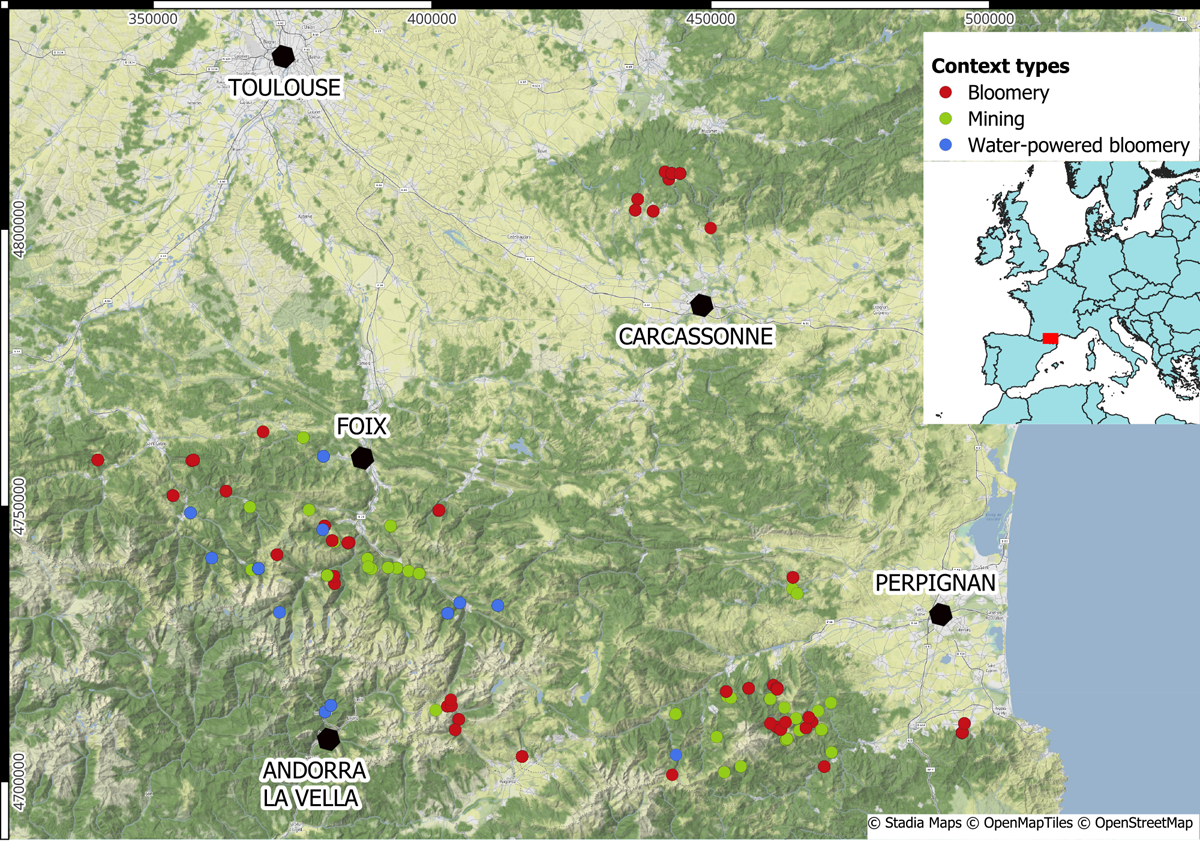
Figure 1
Location of the archaeological contexts from which samples have been collected.
Temporal coverage
The oldest contexts in this dataframe are dated from the late Republican period (late 2nd century BCE and 1st century BCE). The activity in the latest context ceased in CE 1876 (farga Areny in Ordino, Andorra). If further analyses are carried out in the future as part of ongoing research programmes, new versions of the dataset could extend either the time frame or the geographical scope.
(2) Methods
The samples of iron ore and smelting slag analysed come from archaeological sites associated with mining or with smelting iron ore using the direct process – meant as ore smelting without metal fusion; air flow is granted either by natural convection or by bellows operated by man- or water-power. Numerous archaeological excavation campaigns have been carried out using a methodology adapted to the mountainous environment [21] in order to uncover sites, collect samples and describe the archaeological contexts. The samples were then prepared in the laboratory and analysed. Most of the data presented here has been acquired by the Service d’Analyse des Roches et Minéraux (SARM) of the Centre de Recherches Pétrographiques et Géochimiques (CRPG). The chemical data were then uploaded into the CHIPS database [10].
Steps
Ore and metallurgical slag are crystalline materials generally composed of several chemically-distinct mineral species at the microscopic scale. Therefore, at this scale, the distribution of chemical elements is not homogeneous. Nevertheless, this heterogeneity decreases as the observation scale increases (at centimetre or decimetre scales). As a result, global chemical methods such as mass spectrometry on samples of sufficient size are the most suitable to obtain representative results. The analytical protocols have been adapted to this constraint and consist in:
- Collection of samples in the field (Figure 2); between 10 and 20 samples of slag, minerals and wall fragments are taken from each archaeological site. Slag samples exhibiting a flow-like morphology were prioritised, as they indicate the formation of a liquid slag bath within the furnace. The chemical composition of this bath is more representative of the furnace charge than that of a slag fragment formed locally within the furnace. The site is described: location, state of preservation, environment.
- Cutting of samples in the laboratory; a diamond-bladed cutter is used to cut 1 to 3 cm3 cubes from the centre of the samples. Although this sample size does not completely prevent representativity issues, it proved empirically to be the most balanced in terms of sampling practicality, packaging, and sample pulverisation. Samples are then dried.
- Grinding and pulverisation of samples; the samples are crushed in crushers (steel-manganese alloy) if necessary, then reduced to powder in planetary mills equipped with agate balls. The powder obtained has a particle size of less than 80 µm.
- Porphyrization of the powder using lithium or sodium borate.
- Spectrometric analysis, either ICP-AES or ICP-MS.
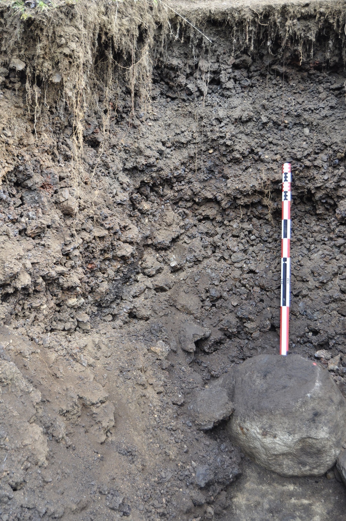
Figure 2
Trench dug in the main slag heap of site ‘Najar 02’, showing a dense accumulation of slag material.
Sampling strategy
If several types of slag and ore are visible at the same site, samples are taken for each type (Figure 3). In the laboratory, cutting a cube from the core of the sample allows both a macroscopic examination of the material’s texture and prevents contamination from the environment. Preference is given to slag with morphology evocating fluidity, which indicates the formation of a liquid bath in the furnace. This helps to prevent chemical heterogeneities within the material.
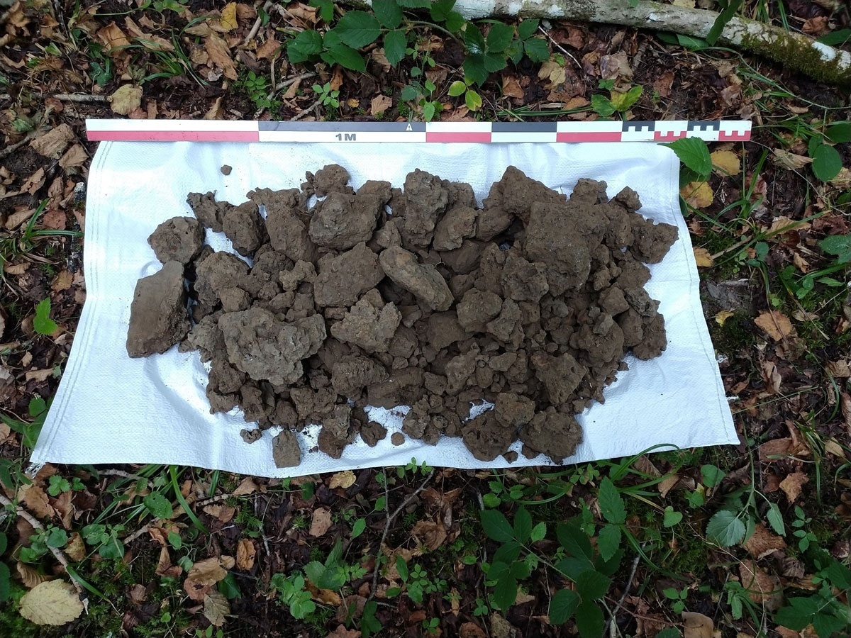
Figure 3
On-field selection of slag for sampling.
Quality Control
The quantifications performed by a given chemical analysis device are more or less close to the actual contents of the chemical elements. This quality of chemical data is represented by a relative measurement error value. To determine these relative errors, analysis laboratories use geostandards, materials for which the contents of chemical elements are determined with great accuracy and certified. At SARM, a series of 25 to 30 analyses are performed on each geostandard [4]. The relative measurement error is obtained by comparing the measured values with the certified values. Checks are carried out frequently, usually every few months. Analytical laboratories provide relative measurement error values, either in the form of articles submitted to geochemistry journals or in the form of technical documents or certificates. The values provided by the laboratories have been incorporated into the CHIPS database in the form of reference tables. Each analysis included in the database is referenced by the laboratory that performed the analysis and the analytical device model. If this information is available, an automatic trigger function calculates the relative measurement errors when each new analysis is added to the database [10].
Constraints
The chemical characterisation of materials, and especially the measurement of trace elements, requires appropriate preparation protocols. Grinding, pulverising and sieving equipment must be thoroughly cleaned after each sample. This requires a great deal of time and advanced skills.
(3) Dataset description
Object name
The file uploaded on Zenodo is named ‘FERAPO_FERMAPYR_Data_v2’.
Data type
The dataset consists of 139 columns. The first column is the analysis order number in the dataset (integer type). The next 9 columns (from ‘context_name’ to ‘northing’) contain data related to the discovery context of the analysed sample. The data is of the “text” type, except for ‘easting’ and ‘northing’, which are of the “numeric” type. The ‘period_name’ column is documented using the PeriodO gazetteer. The authority referred to is the INRAP (the French Institut National de recherches Archéologiques Préventives). It uses the PACTOLS chronology (DOLIA data). Thirteen columns contain data describing the material analysed and the analysis techniques. Of these 12 columns, 9 precede the chemical data related to the major elements (from ‘sample_name’ to ‘major_analytical_method’). The data is of the “text” type, except for the ‘chips_id’ and ‘lab code’ columns, which are of the integer type. ‘chips_id’ refers to the unique identifier of the analysis in the CHIPS data repository, and lab code is the analysis number assigned by the laboratory that performed the measurements. The following 20 columns (from ‘na’ to ‘fe_err’) express the amounts (as element concentrations) of the elements considered to be major, as well as the associated measurement errors. One column expresses the fraction of volatile elements in the material: loss on ignition. The data in these 21 columns are of the “numeric” type and expressed as a percentage. The next two columns (‘isotope_method’ and ‘isotope_analytical_setup’) are of the “text” type and contain metadata related to isotopic analyses. Information related to isotopic data is expressed in the columns ‘deltafe56’, ‘deltafe56_err’, ‘deltafe57’ and ‘deltafe57_err’. The data is of the “numeric” type and is expressed in ‰ (delta notation). The next two columns (‘trace_method’ and ‘trace_analytical_setup’) are of the ‘text’ type and contain metadata related to trace element analyses. The next 88 columns (from ‘as’ to ‘zr_err’) express the contents related to elements considered to be major, as well as the measurement errors associated with them. They are of the “numeric” type and are expressed in µg.g–1. The type constraint has led to choose a numeric code to express values that are reported as below limit of detection. ‘–1’ has been chosen as it is easy to spot visually, and negative values are outside the range of possible chemical concentration values, as these are strictly positive. Empty cells indicate that the given element has not been analysed. The ‘reference’ column is of the “text” type and, where applicable, provides the reference of the publication in which the data were presented. The last three columns (‘reference_url’, ‘periodo_ark’ and ‘pactols_ark’) are text type and contain the URLs to the publications and controlled vocabularies that were used to define the chronological periods and types of materials.
Format names and versions
The data is presented in a CSV format table. The character encoding is UTF-8. Values are delimited by semicolons. The dataset is in version 2. Future versions will be published, adding chemical data acquired through new analyses of slag and ores, or from new publications.
Creation dates
The oldest analyses listed were carried out in 1991. They were performed by the Rock and Mineral Analysis Service in Nancy, at the request of F. Tollon and A. Ploquin. The most recent analyses were carried out in 2024 as part of the FERAPO programme.
Dataset Creators
Data collected during FERMAPYR and FERAPO programmes result in a collective effort involving the individuals listed below. A great deal of effort was devoted to field research, consisting of oral enquiries, research in archives, and surveys. Most of the contexts are previously unknown and their discovery was only made possible through extensive collaboration. Those who participated in data collection are listed in the table below:
Language
Data is presented in English.
License
The data has been deposited under the CC BY-NC open license.
Repository location
The dataset has been uploaded on the Zenodo repository, as part of the IRAMAT community. The DOI of the dataset is 10.5281/zenodo.17992515. The location of the file is: https://doi.org/10.5281/zenodo.17992515.
Publication date
The dataset was deposited in the repository on 1 December 2025 and published on 29 January 2026.
| FIRST NAME | LAST NAME | AFFILIATION | ROLE |
|---|---|---|---|
| Marie | Albéric | UMR7574 LCMCP | Fieldwork, sampling |
| Mathieu | Baiget | Volunteer | Fieldwork, sampling |
| André | Balent | Volunteer | Fieldwork, sampling |
| Monique | Balent | Volunteer | Fieldwork, sampling |
| Cédric | Beauval | Volunteer | Fieldwork, sampling |
| Patrick | Berlureau | Volunteer | Fieldwork, sampling |
| Mathilde | Bernard | UMR7065 IRAMAT | Data collector |
| Sandrine | Bienfait | Volunteer | Fieldwork, sampling |
| Céline | Bosse | Volunteer | Fieldwork, sampling |
| Béatrice | Breton | Volunteer | Fieldwork, sampling |
| Philippe | Cabau | Volunteer | Fieldwork, sampling |
| Simone | Calmettes | Volunteer | Fieldwork, sampling |
| Thomas | Charpentier | Volunteer | Fieldwork, sampling |
| Odette | Cledou | Association Pyrène | Fieldwork, sampling |
| Jean-Claude | Coulet | Volunteer | Fieldwork, sampling |
| Wilfried | Delahaie | Volunteer | Fieldwork, sampling |
| Maël | Delahaie | Volunteer | Fieldwork, sampling |
| Philippe | Dillmann | Volunteer | Fieldwork, sampling |
| Alexandre | Disser | UMR7065 IRAMAT | Fieldwork, sampling, database conception, data curation |
| Christian | Donzeau | Volunteer | Fieldwork, sampling |
| Claude | Dubois | Association Pyrène | Fieldwork, sampling |
| Nathalie | Dupuy | Volunteer | Fieldwork, sampling |
| Philippe | Fernandez | Forges de Pyrène | Fieldwork, sampling |
| Pascal | Gauthier | Volunteer | Fieldwork, sampling |
| Jean-Marie | Giorgio | Volunteer | Fieldwork, sampling |
| Aurore | Gourinel | Volunteer | Fieldwork, sampling |
| Olivier | Guardiole | Volunteer | Fieldwork, sampling |
| Pierre-Marie | Guihard | UMR6273 CRAHAM | Fieldwork, sampling |
| Florence | Guillot | UMR5608 TRACES | Fieldwork, sampling |
| Claude | Guisset | Volunteer | Fieldwork, sampling |
| Tobias | Heal | Liège University & UMR7065 IRAMAT | Fieldwork, sampling |
| Pauline | Illes | Volunteer | Fieldwork, sampling |
| Jérôme | Kotarba | INRAP | Fieldwork, sampling |
| Maxime | L’Héritier | Université Paris 8 & UMR7041 ArScAn | Fieldwork, sampling |
| Jean-Noël | Lamiable | Association Pyrène | Fieldwork, sampling |
| Denis | Langlois | Volunteer | Fieldwork, sampling |
| Jordi | Mach | UMR7041 ArScAn | Fieldwork, sampling, sample preparation |
| Sybille | Manya | UMR8546 AOROC | Fieldwork, sampling |
| Michel | Martzluff | Volunteer | Fieldwork, sampling |
| Jean-Paul | Mathé | Volunteer | Fieldwork, sampling |
| Jean-Charles | Méaudre | UMR7065 IRAMAT | Fieldwork, sampling |
| Jean-Paul | Métailié | UMR5602 GEODE | Fieldwork, sampling |
| Gérard | Mut | UMR5608 TRACES | Fieldwork, sampling |
| Sébastien | Nègre | Volunteer | Fieldwork, sampling |
| Éloïse | Nègre | Volunteer | Fieldwork, sampling |
| Gaspard | Pagès | IFPO | Fieldwork, sampling, database conception, data curation |
| Clarence | Pagès | Volunteer | Fieldwork, sampling |
| Charlyne | Pagès | Volunteer | Fieldwork, sampling |
| David | Parisi | Volunteer | Fieldwork, sampling |
| Jean | Ribot | Volunteer | Fieldwork, sampling |
| Mattéo | Rivaud | Volunteer | Fieldwork, sampling |
| Guillaume | Sarah | UMR7065 IRAMAT | Fieldwork, sampling |
| Jacques | Ségala | Volunteer | Fieldwork, sampling |
| Jacques | Taurinya | Volunteer | Fieldwork, sampling |
| Florian | Téreygeol | UMR7065 IRAMAT | Fieldwork, sampling |
| Michel | Thouzery | Volunteer | Fieldwork, sampling |
| Rodrigue | Tréton | UMR5608 TRACES | Fieldwork, sampling |
| Enrique | Véga | UMR7065 IRAMAT | Fieldwork, sampling, sample preparation |
| Catherine | Verna | Université Paris 8 & UMR7041 ArScAn | Fieldwork, sampling |
| Alain | Vignaud | Volunteer | Fieldwork, sampling |
| Marc | Zéziola | Volunteer | Fieldwork, sampling |
| Estrella | Volunteer | Fieldwork, sampling | |
| Tina | Volunteer | Fieldwork, sampling |
(4) Reuse potential
The main objective of this dataset is to provide easy access to reference analysis results for a reference metallurgical area in ancient Western Europe (the north-eastern part of the Pyrenees and the Montagne Noire). The data can be used to characterise the techniques that were implemented in this area, where metallurgists developed a specific technical tradition – based on the direct process – for iron production. This data can also be used by the international scientific community in the context of provenance studies to determine how ferrous alloys circulated in ancient times, but they can also be used for studies on the use of iron ore in ancient medicine or iron ores as colourants [22]. Recent publications have shown that ferrous alloys were commonly traded over distances of several hundred or even thousands of kilometres [14, 20]. In this case, product mobility can be facilitated by the geographical location of the production areas, close to a dense network of land, sea and river transport routes at the interface between the Mediterranean Sea, present-day France and the Iberian Peninsula.
Particular care has been taken to provide information on the quality of the data presented. Relative measurement errors have been calculated based on information provided by the analytical laboratories. The laboratories and analytical equipment used are also systematically listed. We have formatted the data using standards (use of geographical coordinates according to the WGS84 system, use of the PeriodO gazetteer and the Pactols thesaurus, etc.) and the most widespread practices in the archaeological and archaeometric research communities.
The dataset will soon be distributed online via an API, which facilitates data reuse. This API is used, for example, by the CHIPS database data exploration dashboard (https://iramat-apps.cnrs.fr/dash/) for easy data visualisation. The structure of the dataset is compatible to that of the other datasets presented on the dashboard, which facilitates the intercomparison of data for meta-analyses. Finally, this API can be used by other applications, such as the online interface of the FERMAPYR project (FNP-FERMAPYR-UI), which is hosted by the Fabrique Numérique du Passé platform [5].
Acknowledgements
The authors wish to express their gratitude to everyone who provided assistance in the field but is not named in this article. The authors want to thank Thomas Huet (CNRS IRAMAT UMR7065) for advice on the submission of this datapaper.
Author Contributions
Both authors have coordinated the fieldwork campaigns during which the samples have been collected. Both authors managed sample preparation, description and registration. Both authors have managed the datasets acquired during the FERAPO and FERMAPYR projects. Alexandre Disser has formatted the dataset in the way it is stored on Zenodo. Both authors have contributed to the writing of this paper.