
(1) Overview
Context
The megalithic landscape of the Gor valley is one of the largest tomb clusters in Europe, with 238 megaliths documented in the first general inventory campaign carried out at the end of the 19th century [19]. Besides, these dolmens are one of the main examples of what has been called the Megalithic Phenomenon of the South-East of Iberia (Figure 1), characterised by the appearance of large densities of small sepulchres with a high typological and constructive variability [15], in part due to the wide time frame in which the burial mounds were built and used (Final Neolithic – Bronze Age).
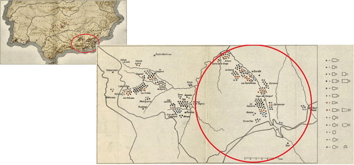
Figure 1
Megalithic area on the southeast of the Iberian Peninsula, [16].
Despite its great importance for the knowledge of Megalithism and Late Prehistory both in the region and in a wider scale, throughout the 20th century research on these tombs has been very scarce, standing out the work published by [14] in which a new record and documentation of all the megaliths was carried out. At this time, the problems derived from the first campaigns became evident, as the numbering and nomenclature of the drawings and descriptions did not fit with what was observed in the field. To this situation must be added the serious problem of conservation and loss of megaliths: in this campaign only 198 of the 238 graves could be documented. In view of all this, a new indexing of the graves between 1 and 198 was carried out in this work, and this is the numbering that has been used in subsequent works (including the present one).
From this point on, research was halted until the final decade of the 20th century, when a new survey was carried out with the aim of geo-referencing the megaliths preserved for their protection as BIC (Bien de Interés Cultural or Cultural Interest Item). This new campaign succeeded in documenting only 142 megaliths [20]. This new documentation led to the publication of some works that considered the existence of a series of differences among the tombs related to their locations [1] or their typological traits, considering the smaller and more irregular sepulchres as the most ancient in the group [2, 3]. In addition, the existence of important visual relationships between the megaliths and between them and the territory, mainly emphasising the passageways between the valley and the high plateau [20] and the design of a complex system of territorial visual domain over the entire valley were asserted [10].
Finally, the importance of the Gor river complex has led to the study of the entire grouping in the course of a PhD thesis recently defended in July 2023 [12]. This thesis has focused on the study of the spatial issues of the burial mounds on three scales: the study of the megaliths individually and in relation to the necropolis to which they belong, the study of the relationship between the different necropolises, and the study of the megaliths and the necropolises in relation to the territory. The basis of this work has been a new surface survey with the aim of documenting a series of variables that had not been recorded to this date and the creation of a geographical database based on the georeferencing of the tombs. This survey has allowed the georeferencing of 151 megaliths (Figure 2). These are the data presented in this paper.
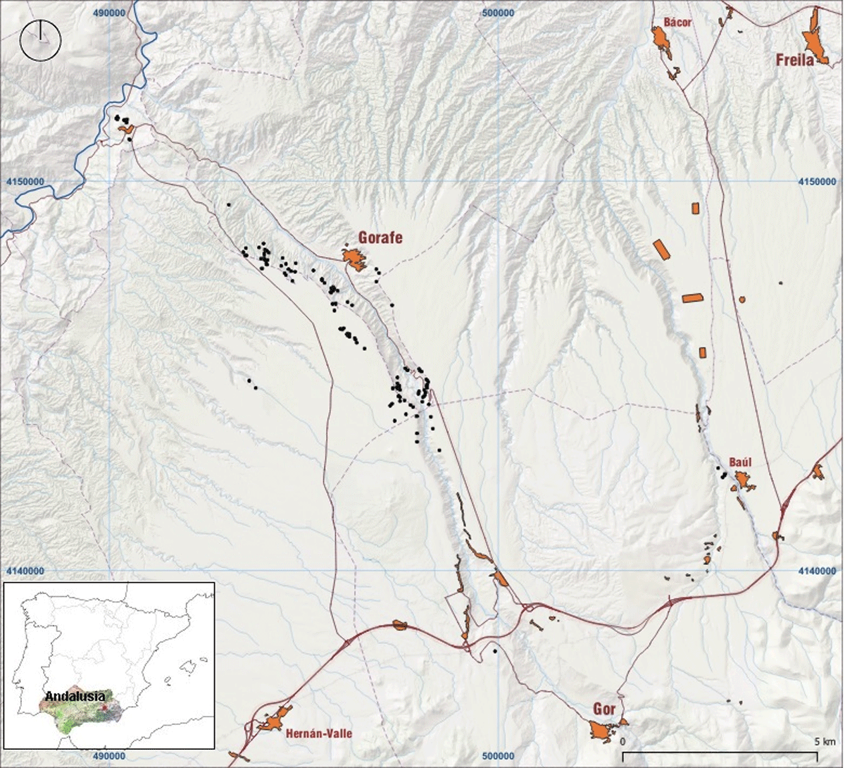
Figure 2
Location of the 151 documented dolmens along the Gor River valley.
To these first data, are added those resulting from a digital survey carried out by means of a terrain survey using DTMs based on LiDAR data that have emerged in the course of the analyses carried out in the aforementioned doctoral thesis [9]. These data are the result of a new cartographical review of the terrain surface in which the known megaliths are located, which has led us to the detection of 230 anomalies compatible in shape and size with burial mounds (Figure 3). While some of these anomalies have been checked out in field (considering as megalithic mounds 9 out of 25 positions), the most part of these locations haven’t been directly reviewed, but a geographical database similar to the one created for the analysis of the 151 registered megaliths have been completed in order to carry out a comparative spatial study between them and to determine in a more accurate way which are the anomalies with more possibilities of being (or to have been) megalithic mounds.
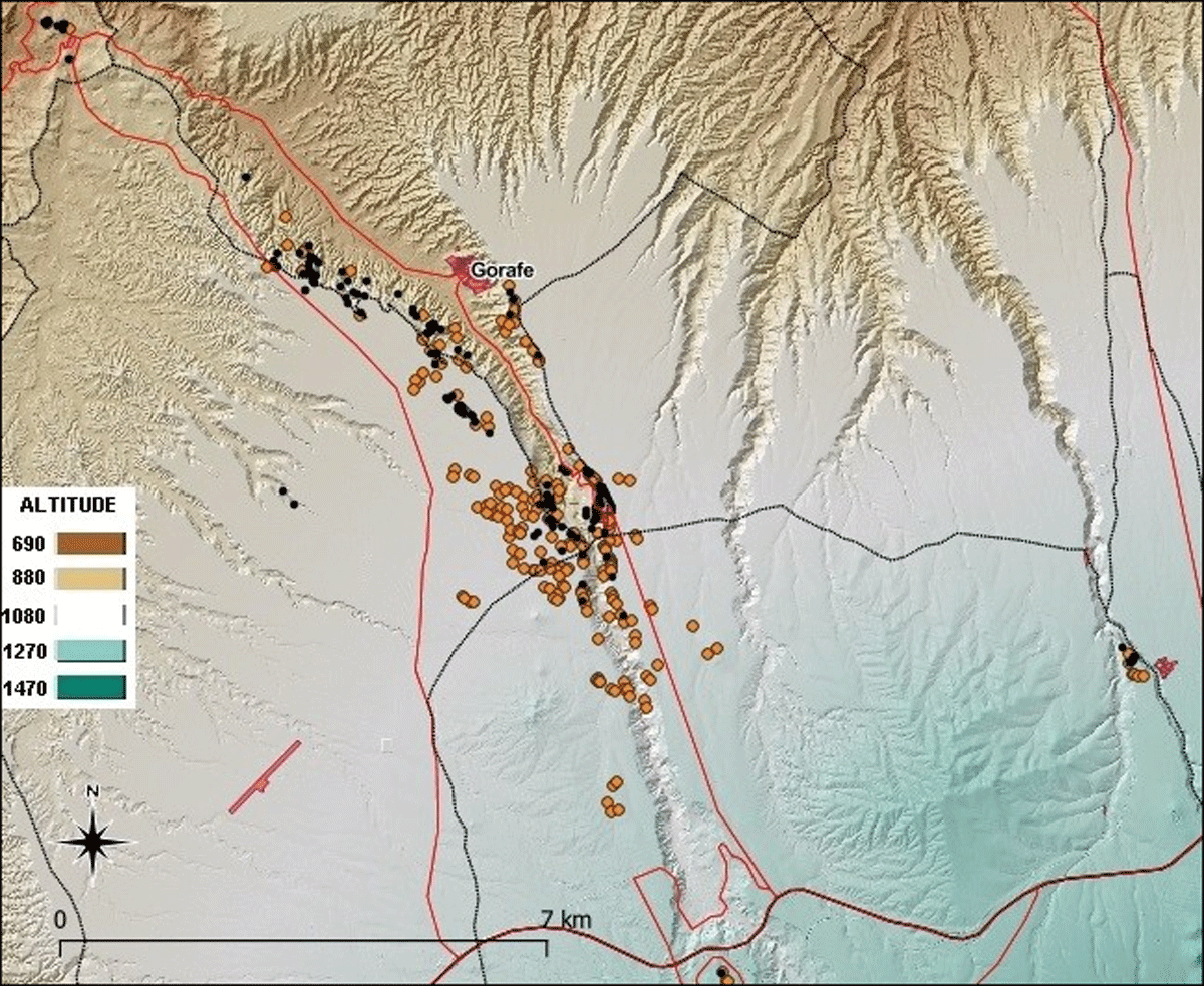
Figure 3
In black, the 151 megaliths identified in the terrain. In orange, the 230 new possible megaliths identified by DTMs based on LiDAR data. Taken from [9].
Spatial Coverage
ETRS89/UTM zone 30N [EPSG: 25830]
Description: South-East of the Iberian Peninsula
Geographically, it is a very rugged terrain with strong contrasts, where the vertebral axis is the Gor river valley, but there are also abrupt ravines created during millennia of strong erosion on the landscape (the so called “badlands”), as well as a vast high plateau in the highest area.
Northern boundary: 4154689,90
Southern boundary: 4134962,30
Eastern boundary: 487140,80
Western boundary: 508909,20
Temporal Coverage
The general chronology regarding the construction and primary use of the megaliths is comprised between the Late Neolithic and the beginning of the Bronze Age (from the beginnings of the 4th millennium to the end of the 3rd millennium BC), although most of the tombs were probably built during the Chalcolithic (3rd millennium BC), as it is common in this region [4, 5, 6, 7] and many of them were reused during Late Bronze Age [17]. These chronologies have been established mainly on the basis of the materials found in the grave goods, while only 11 radiocarbon dates obtained on bone fragments from the burials are available, which provide information on the times of use and reuse of the graves. These dates point to the existence of reuse after the construction of the megaliths, especially during the Final Bronze Age (Table 1, Figure 4), in many cases without previous evidence of items belonging to these dates.
Table 1
Results of radiocarbon dating and samples analysed. N = number of the megalith where the dated bone was found. Calibration according to IntCal20 [18]. Using Calib 8.1.1. program.
| N. | BONE PART | AGE | GENDER | DATES BP | CULTURAL PERIOD |
|---|---|---|---|---|---|
| 65 | radius | adult | 2690 ± 30 | Final Bronze Age | |
| 67 | talus | adult | male | 3839 ± 31 | Final Copper Age |
| 67 | humerus | adult | 2796 ± 30 | Final Bronze Age | |
| 68 | ulna | adult | 2740 ± 30 | Final Bronze Age | |
| 69 | femur | adult | male | 2748 ± 30 | Final Bronze Age |
| 70 | tibia | adult | 2719 ± 31 | Final Bronze Age | |
| 70 | skull (occipital) | adult | 4120 ± 32 | Copper Age | |
| 71 | humerus | adult | 3659 ± 31 | Final Copper/Ancient Bronze Age | |
| 103 | fibula | adult | male | 4307 ± 33 | Ancient Copper Age |
| 112 | tibia | adult | 3358 ± 30 | Bronze Age | |
| 132 | humerus | adult | 3729 ± 32 | Final Copper Age |
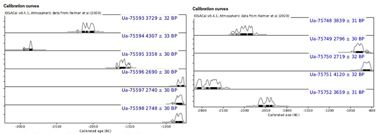
Figure 4
Results of the radiocarbon dates.
(2) Methods
Steps
The first step in the collection of data was the surface survey, which was eminently extensive as it had to be adapted to a very vast area of about 100 km2, in which there are very diverse areas of valley, ravine and high plateau. Due to the vastness of the area, it has been necessary to continually resort to information from previous campaigns. The fundamental data collected were the UTM X and Y coordinates of the individual tombs, but also other constructive and typological data (architectural typology, presence or absence of corridors, measurements preserved, etc.) or data related to the environment of the megaliths (orientation of the corridors in relation to geographical landmarks, visual relationship with respect to other megaliths, level of erosion of the terrain, etc.). In the course of this survey, 5 new megaliths have been documented and identified with numbers from 300 onwards to avoid overlapping with previous records.
Once this recording had been carried out, the data was dumped in .csv format for viewing and management using GIS software. The software chosen was QGIS, in different versions that can be downloaded free of charge from its website https://qgis.org/es/site/forusers/download.html (consulted on 05/09/2023). From the exact coordinates of the megaliths, a series of variables have been calculated from the aforementioned software, using the basic cartography offered by the Andalusian Institute of Statistics and Cartography, the National Geographic Institute and the Spanish Geological and Mining Institute. These variables are related both to the location of the megaliths and to the characterisation of the terrain in which they are placed or to the relationship between the tombs both individually and with respect to the necropolis to which they belong and between them and the territory. The data were obtained by analysing historical and modern cartography, both vectorial and raster.
Finally, data obtained from old publications have also been included, being the main reference work the one published in 1959 by [14] Spahni “Los sepulcros megalíticos de la región de Gorafe (Granada)”. These data refer mainly to constructive and typological features. With all this, it has been possible to create an extensive geographical database made up of a total of 70 quantitative and qualitative variables (Table 2, Figure 5).
Table 2
General squeme of the variables.
| VARIABLE CATEGORIES | VARIABLES |
|---|---|
| Id | Identification |
| Location | Coor. X, Coor. Y., Area, Municipality, etc. |
| Constructive | Typology, Orthostates of the chamber, Orthostates of the corridor, Chamber lenght, Chamber width, etc. |
| Spatial | Orientation of the corridor, Viewshed, Slope, Height, Distance to the Gor River, etc. |
| Others | Conservation status, Geology, Lithology, Erosion, etc. |
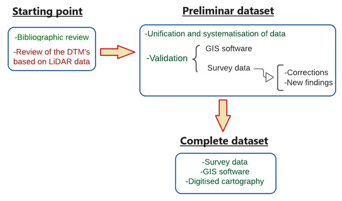
Figure 5
Conceptual model of data collection, processing and validation. In green, the model of the first dataset. In red, the model of the second dataset.
On the other hand, one of the studies carried out in the course of the aforementioned doctoral dissertation has been the revision of the terrain by means of DTMs generated by LiDAR cartography, offered by the National Geographic Institute (https://pnoa.ign.es/el-proyecto-pnoa-LiDAR, consulted on 05/09/2023). Both the technical specifications and the process of the filtering of the DTMs and the development of the digital survey can be consulted in [9]. This remote terrain survey has resulted in the identification of 230 anomalies compatible with megaliths scarcely preserved on the surface, from which only 25 have been reviewed in field. Using the UTM X and Y coordinates obtained from this cartographic review, a geographical database has been compiled containing nearly 25 variables (altitude, average, minimum and maximum altitude, slope, average, minimum and maximum slope, distance to the Gor river, etc.). These data would allow a comparative study of the spatial characteristics of both the 151 megaliths actually documented and these 230 possible sites in order to determine which of the 230 anomalies could more easily correspond to megalithic mounds. This database has been created entirely from the digital ground survey and through calculations carried out using GIS algorithms. In both cases, the software used was again QGIS.
Sampling Strategy
The data presented have been collected in different ways. For the first database, concerning the 151 megaliths preserved in the Gor River, an initial part of the variables have been taken in the field during the survey (UTM X and Y coordinates, typology of the tomb, level of preservation, orientation of the corridor -if any-, preserved measurements, etc.), while a large part of the data has been obtained through calculations carried out with GIS software (altitude or Z coordinate, distance to the Gor River, distance to bodies of water, slope and minimum and maximum slope, orientation of the terrain, etc.) and some others have been taken from both historical and modern digitised cartography (erosion, geology, lithology, land use, etc.) and from old publications (typology documented in other campaigns, measurements formerly documented, information on the grave goods).
For the second database concerning the 230 points identified by means of DTMs created from LiDAR data, the complete set of almost 25 variables have been calculated by means of GIS algorithms (UTM X and Y coordinates, altitude, average, minimum and maximum altitude of the terrain around the points, average, minimum and maximum slope around the points, distance to the Gor River, etc.).
Quality Control
The set of 151 megaliths has been documented following the information from previous campaigns, standing out the data referring to the publication of [14] Spahni in 1959 [14] and the data from the survey at the end of the 20th century [1, 20]. The great extension (around 100 km2) and complexity of the terrain, which includes high plateau areas as well as ravine and valley areas, means that an undetermined number of megaliths or partially destroyed megalithic structures have probably not been documented, which is reflected in the gap between the high number of burial mounds documented in the first campaigns and the megaliths preserved today. These problems explain the fact that a high number of bad preserved mounds could be localised by LiDAR techniques as shown by the field review in restricted areas [9] Likewise, the level of preservation of the tombs themselves makes it difficult to document some variables, such as the typology of the chambers or the measurements preserved. In order to alleviate these difficulties, an attempt has been made to establish wide classifications of these characteristics.
In any case, the fundamental variables obtained in the course of this survey are the UTM X and Y coordinates, which were subsequently checked and adjusted using modern cartography (DTM, orthophotos) in order to eliminate as much as possible of the margin of error in the precision of the GPS used. In this way, we have tried to ensure that we are as accurate as possible in calculating the variables obtained from this information.
In the case of the database with the 230 points likely to be partially destroyed megaliths, as there is no documentation in the field, the coordinates have been entirely obtained and adjusted based on the observation of modern cartography, which provides a certain degree of security for the rest of the calculations carried out.
Constraints
The main constraints of this dataset are fundamentally related to preservation, which prevents the correct observation in the field of some of the documented variables (and even of some burial mounds as shown by LiDAR results). The loss of part of the length and width of the orthostats and even the displacement or inclination of them makes it difficult to establish a constructive typology of the tombs and their different parts. The same applies to the taking of measurements, especially the height of the orthostats.
In the case of the second database made from LiDAR data, the problems are related to the resolution of the cartography analysed and the topography of the terrain itself, since, being so abrupt, it is not easy to establish filters that allow the correct visualisation of the whole terrain, being especially difficult in the case of the areas of ravines and ridges. On the other hand, it should be taken into account that the small size of these megalithic structures (median chamber length of 2 m, median corridor length of 1 m, following [13]) means that they are not so easy to document due to the level of resolution available so far for LiDAR data (1 m2 / pixel).
(3) Dataset description
Object name
Gor_data
Gor_LiDAR_data
Data type
Primary Data.
Format names and versions
.csv, .xlsx
Creation dates
15/05/2019 – 15/12/2022
License
CC BY 4.0, Creative Common License
Repository Location
Dataset Creators
The data from the survey of the megaliths carried out in 2019 were taken by Carolina Cabrero González and José Antonio Bueno Herrera. The data calculated using GIS and statistics were created by Carolina Cabrero González and reviewed and corrected by Antonio Garrido Almonacid, Francisco Javier Esquivel Sánchez and Juan Antonio Cámara Serrano. The data from both historical and digital cartography have been taken by Carolina Cabrero González from information provided by the IGN (National Geographic Institute), IGME (Geological and Mining Institute of Spain) and the Junta de Andalucía. The data taken from old publications have been obtained from the work of [14] “Los sepulcros megalíticos de la región de Gorafe (Granada)”.
Language
Spanish and English
(4) Reuse potential
In neither of the two databases here presented the potential has been fully exploited. In the case of the dataset of the 151 megaliths, not all of the 70 variables have been analysed, but only some of them have been observed, such as altitude, orientations or distance to the River Gor, which have been used to make new groupings between the megalithic necropolises or to describe some general patterns of them, as well as to analyse the construction patterns of the megaliths [11, 13]) or to make some “minor” studies as a valuation of the preservation status of the megaliths [8]. These 70 variables, which include both quantitative and qualitative data, would allow a broad analysis that could even allow the study of the evolution of some of the characteristics such as the preserved measurements or the typologies observed, even in relation to other characteristics such as land use or soil erosion, since we have the data obtained for these variables both in previous campaigns and in the 2019 survey. Likewise, the existence of such a large number of burials would allow us to carry out fairly solid analyses by offering a data set with a high degree of variability and representativeness. On the other hand, this large dataset is useful for comparative purposes with other megalithic areas, especially regarding Iberian Southeast.
In the case of the database related to the 230 possible megalithic locations documented from DTMs carried out using LiDAR data, the variables presented have not yet been analysed as they were calculated with the aim of carrying out a comparative study between them and those obtained for the 151 documented megaliths as a whole but, finally, it was decided to opt for a field valuation of some points as a sample (only 25 out of 230) in order to verify whether or not they would have been megaliths. In this way, the main study that could be carried out is the statistical comparison between both datasets with the aim of filtering which of these 230 points fit better with the characteristics provided by the megaliths actually documented. Besides, the presentation of these data may also allow other teams to check possible new sites by means of surface surveys and even suggest the areas in which it could be interesting to carry out geophysical survey and/or excavation campaigns. In this sense, it must be considered that even with burials whose chambers may have completely disappeared, sometimes due to the plundering activities, corridors could be documented as they are not usually looted, nor even intervened in the unsystematic campaigns of the late 19th century.In both cases, to continue and to extend the analyses could be very interesting as it would serve to deepen the locational patterns of the tombs, serving to contrast the conclusions obtained so far on the spatial logic of the Gor River complex and helping us to understand the spatial decisions made up by the communities of the Late Prehistory of the Iberian Southeast in order to anthropize and to demarcate the exploitation areas.
Data Accessibility Statement
Funding information
This work is also related to the development of the projects (1)”Producción artesanal y división del trabajo en el Calcolítico del Sudeste de la Península Ibérica: un análisis a partir del registro arqueológico de Los Millares (PARTESI) (PID2020-117437GB-I00/AEI/10.13039/501100011033)” financed by the Agencia Estatal de Investigación del Ministerio de Ciencia e Innovación, (2) ”Dinámicas de continuidad y transformación entre el Neolítico y el Calcolítico en el Alto Guadalquivir (DINAGUA) (Proy_Exc00002)” funded by the Consejería de Universidad, Investigación e Innovación de la Junta de Andalucía, (3) ”Arqueobiología del Neolítico del Sur de la Península Ibérica – NeArqBioSI (A-HUM-460-UGR18)” funded by the Consejería de Universidad, Investigación e Innovación de la Junta de Andalucía and framed in Programa Operativo FEDER Andalucía 2014–2020. Convocatoria 2018 e “Imagen e Ideología en la Prehistoria Reciente de Granada (IMIDEGRA) (A-HUM-262-UGR20)” funded by the Consejería de Universidad, Investigación e Innovación de la Junta de Andalucía and framed in the Programa Operativo FEDER Andalucía 2014–2020. Convocatoria 2020.
Competing Interests
The authors have no competing interests to declare.