
Introduction
Sustainable development has become a dominant paradigm shaping public policies worldwide, supported by global and regional financing mechanisms. In this context, the Sustainable Development Goals (SDGs) adopted under the United Nations 2030 Agenda, provide a comprehensive normative framework guiding national development strategies Increasingly, scholars have highlighted how the SDGs influence policy prioritization, particularly in sectors such as urban development, infrastructure, and environmental management (Biermann et al., 2017; Fukuda-Parr, 2016).
In Benin, the integration of SDG targets into national planning instruments reflects a broader trend across Sub-Saharan Africa, where sustainability agendas are closely linked to international funding and development cooperation. However, the operationalization of the SDGs within national policy frameworks raises critical concerns regarding the governance of local commons. A growing body of literature in political ecology and commons theory suggests that sustainability-driven interventions may inadvertently, or strategically, marginalize local institutions by privileging state-led and market-oriented governance models (Haller, 2022; Larsen et al., 2022). This dynamic is often conceptualized as “commons grabbing,” referring to processes through which collectively managed resources are appropriated or reconfigured under external pressures, frequently justified in the name of conservation or development (Fairhead et al., 2012; Haller, 2019; Gmür et Haller, 2023).
Urban wetlands constitute a particularly relevant context for examining these dynamics. These ecosystems provide critical ecosystem services, including flood regulation, water purification, biodiversity conservation, and livelihood support for urban populations (MEA, 2005; Ramsar Convention Secretariat, 2018). In many African cities, wetlands have historically been governed through common property institutions, enabling access to diverse common-pool resources (CPRs) such as fisheries, grazing land, and plant materials (Kuusaana et al., 2021). These governance systems are embedded in complex institutional arrangements characterized by legal pluralism, where customary norms coexist and interact with statutory regulations (Wegerif et al., 2025; Meinzen-Dick & Pradhan, 2002; Bah and Teguia Kenmegne, 2025).
The rapid urbanization and the expansion of infrastructure projects are intensifying pressures on urban wetlands across Sub-Saharan Africa (Mumuni et al., 2025). These pressures are often driven by state authorities and private investors seeking to convert wetlands for real estate development, industrial use, or urban infrastructure (Watson, 2014). These dynamics often result in the selective recognition, or exclusion of local institutions, depending on their alignment with dominant development agendas. Recent studies further emphasize the need to understand these transformations through the lens of institutional political ecology, which focuses on how power, knowledge, and institutional arrangements interact to shape access to and control over natural resources (Cleaver, 2012; Haller, 2019). In this regard, the work of Akuoko et al. (2025) demonstrates how the interplay between customary and statutory systems can sustain informal governance arrangements while simultaneously exposing them to marginalization in formal urban planning processes. In Benin, land governance is characterized by a dual system combining statutory reforms and customary practices. The introduction of modern land legislation, including efforts to formalize land rights and promote land registration, aims to enhance tenure security and attract investment (Adéchinan and Bako, 2025; Ekpodessi and Nakamura, 2018; World Bank, 2020). However, these reforms often prioritize individualized property rights, thereby undermining collective forms of resource governance and weakening the institutional foundations of local commons (Ekpodessi and Nakamura, 2018). In urban areas such as Cotonou, these tensions are further reinforced by SDG-aligned policies, particularly those related to sanitation (SDG 6), infrastructure (SDG 9), and ecosystem conservation (SDG 15).
The Cotonou Pluvial Sanitation Program (Programme d’Assainissement Pluvial de Cotonou, PAPC) exemplifies these dynamics. Designed to reduce flood risks, improve sanitary conditions, and promote urban development, the program reflects the ambition to align local development strategies with global sustainability agendas. Similar large-scale urban infrastructure projects have been shown to reshape urban socio-ecological systems, often producing uneven outcomes across different social groups. While the objectives of the PAPC are socially and environmentally justified, a closer examination reveals a critical gap: the limited recognition of local common property institutions and indigenous ecological knowledge in the design and implementation of the program. The wetlands targeted by the PAPC are traditionally used by local communities, particularly the Seto and Xla groups, who depend on a wide range of CPRs, including fisheries, pasture, avifauna, and diverse plant resources used for food, medicine, and construction (Atchadé et al., 2023; Lougbégnon and Codjia, 2011). Empirical studies have shown that such locally embedded resource use systems are essential for both livelihood security and biodiversity conservation (Atchadé et al., 2023).
Furthermore, preliminary findings from this study indicate that local populations perceive the PAPC not only as a development intervention but also as a potential threat to their access to resources and their customary governance systems. This reflects broader power asymmetries between actors involved in urban resource governance, including state agencies, municipal authorities, private investors, and local communities. These actors mobilize different sources of power legal authority, financial capital, technical expertise, and customary legitimacy to influence resource access and control.
Against this backdrop, the main objective of this study was to analyze the effects of the Cotonou Rainwater Sanitation Program (PAPC) on urban wetland governance, with a focus on its implications for local common property institutions, biodiversity, and local livelihoods. Specifically, the study aimed to (i) analyze the structure and functioning of local wetland governance institutions, (ii) assess ecological diversity and the socio-economic importance of biological resources, (iii) examine local perceptions of PAPC impacts on ecosystem services and resource access and, (iv) analyze governance dynamics and levels of community participation in the PAPC.
By combining qualitative and ecological data, this paper contributes to the literature on urban commons and political ecology by demonstrating how sustainability discourses can legitimize the reconfiguration—and potential appropriation—of local commons in rapidly urbanizing contexts.
Literature Review
Recent scholarship increasingly conceptualizes urban wetlands as complex socio-ecological systems shaped by rapid urbanization, climate pressures, and governance transformations. Across Sub-Saharan Africa, the expansion of cities has intensified land-use changes in wetland areas, leading to biodiversity loss, ecosystem degradation, and growing socio-economic vulnerabilities for populations dependent on these ecosystems (Ramsar Convention Secretariat, 2018; Mumuni et al., 2025). Empirical evidence further shows that wetland fragmentation is strongly associated with population density and urban expansion, highlighting the pressure exerted by demographic growth on these critical ecosystems (Garba et al., 2025; Mitchell, 2013; Abera et al., 2022).
A growing body of recent studies focuses on urban wetland governance and the role of institutions in managing socio-ecological complexity. For instance, Muwafu et al. (2024) emphasize that effective stormwater and wetland management in African cities depends not only on technical solutions but also on community governance, institutional coordination, and regulatory frameworks. Similarly, recent work on urban wetland governance frameworks highlights the need to integrate multiple perspectives, including ecosystem services, adaptive governance, and social-ecological systems approaches—to better capture the complexity of urban wetland management (Yu et al., 2026; Everard et al., 2019; Pan et al., 2023; Sizo et al. 2015; Giurgiu et al., 2023; Ostrom, 2009).
At the same time, empirical research in African cities demonstrates that urban development and infrastructure expansion are key drivers of wetland transformation. Studies conducted in Ghana and Cameroon show that urban growth reshapes wetland landscapes through land conversion, infrastructure development, and weak enforcement of planning regulations, resulting in significant ecological degradation and loss of ecosystem services (Oduro et al., 2024). These findings highlight how urban planning systems often fail to adequately integrate wetlands into development strategies, leading to increased environmental vulnerability.
More recent studies emphasize the influence of global development agendas, particularly the Sustainable Development Goals (SDGs), on urban governance. While SDG-oriented policies aim to promote sustainability and inclusiveness, their implementation often relies on technocratic approaches that may overlook local institutional arrangements (Akuoko et al., 2025). However, empirical evidence remains limited regarding how these global frameworks interact with local commons governance systems, especially in the context of urban wetlands.
Recent contributions from urban political ecology further underline the importance of power relations and stakeholder dynamics in shaping access to wetland resources. For example, studies from Cameroon reveal that wetland governance is characterized by unequal participation and competing interests among state institutions, local authorities, and communities, often resulting in conflicts and exclusion of local users (Kongnso et al., 2024). These dynamics reinforce the argument that urban environmental governance cannot be understood without considering the distribution of power and the institutional arrangements through which it is exercised.
Despite these advances, important gaps remain in the literature. First, while recent studies document ecological degradation and governance challenges, there is still limited empirical work examining how large-scale, SDG-aligned infrastructure projects reshape local commons governance systems. Second, the interaction between customary institutions and formal policy frameworks in urban wetlands remains insufficiently explored, particularly in rapidly urbanizing coastal cities. Third, few studies adopt an integrated approach that simultaneously considers biodiversity, ecosystem services, and local livelihoods within the same analytical framework.
This study addresses these gaps by examining how the Cotonou Rainwater Sanitation Program (PAPC), as an SDG-driven intervention, reconfigures access to urban wetland resources, reshapes institutional arrangements, and affects both ecological systems and local livelihoods.
Theoretical Framing
This study adopts an interdisciplinary theoretical framework combining commons theory, legal pluralism, and institutional political ecology to analyze the transformation of urban wetland governance in Cotonou. This framework enables a nuanced understanding of how institutions, power relations, and development discourses interact to shape access to and control over common-pool resources (CPRs).
The analysis first builds on commons theory, particularly the work of Elinor Ostrom, who conceptualizes CPRs as resource systems characterized by difficulty of exclusion and subtractability (Ostrom, 1990). Her work demonstrates that local communities can sustainably manage shared resources through self-organized institutions based on rules, norms, and collective action. Subsequent studies have expanded this perspective by emphasizing the diversity and adaptability of local governance arrangements in different socio-ecological contexts (Agrawal, 2001; Meinzen-Dick & Pradhan, 2002). However, commons theory has also been criticized for paying limited attention to broader political and economic forces influencing local institutions.
To address these limitations, this study draws on institutional political ecology, which explicitly integrates power, institutions, and environmental governance. As developed by Tobias Haller, this approach highlights how access to natural resources is shaped by the interplay of institutional arrangements, power asymmetries, and ideological narratives (Haller, 2019). It emphasizes that institutions are not neutral but are embedded in social relations and influenced by actors with varying capacities to mobilize authority, knowledge, and resources. This perspective is particularly relevant for analyzing how global development agendas, such as the SDGs, can legitimize interventions that restructure local governance systems.
The framework is further enriched by the concept of legal pluralism, which refers to the coexistence and interaction of multiple normative systems governing land and natural resources (Meinzen-Dick & Pradhan, 2002; Lund, 2008). In many African contexts, statutory law introduced by the state overlaps with customary institutions that continue to regulate resource access at the local level. These overlapping systems create hybrid governance arrangements, but also generate tensions and asymmetries, as state-based legal frameworks often dominate and selectively recognize customary rules (Boone, 2014). Legal pluralism thus provides a critical lens to examine how certain institutions are legitimized while others are marginalized in processes of urban development.
Building on these perspectives, this study conceptualizes urban wetlands as contested socio-ecological systems, where multiple actors, including state agencies, municipal authorities, private investors, and local communities—compete over access to and control of resources. These actors mobilize different forms of power, including legal authority, financial capital, technical expertise, and customary legitimacy, to influence governance outcomes. This aligns with broader insights from political ecology, which emphasize that environmental governance is inherently political and shaped by unequal power relations (Bryant & Bailey, 1997; Robbins, 2012).
Finally, the concept of commons grabbing is used as a central analytical lens. Originally developed in the context of land and resource appropriation (Fairhead et al., 2012), this concept refers to processes through which collectively managed resources are enclosed, redefined, or appropriated under external pressures, often justified by conservation or development objectives. Recent work has extended this concept to examine how sustainability discourses can legitimize such processes (Larsen et al., 2022). In this study, commons grabbing is understood as a process through which SDG-driven interventions may lead to the reconfiguration, and potential marginalization of local common property institutions.
Based on this analytical framework, the study aims to:
examine how urban sanitation policies reshape institutional arrangements governing wetland commons;
assess the extent to which local common property institutions are recognized or marginalized within formal governance systems;
analyze how these governance transformations influence access to resources, biodiversity conservation, and local livelihoods; and
evaluate stakeholder perceptions of the socio-ecological trade-offs associated with these interventions.
Methods and case selection
Study area and case selection
This study was conducted in Cotonou, the economic capital of Benin, characterized by rapid urban expansion and increasing pressure on wetland ecosystems. The city is located in the Littoral department of Benin, more precisely between 6°21’ and 6°24’ north latitude and 2°22’ and 2°29’ east longitude. It is bounded to the north by Lake Nokoué, to the south by the Atlantic Ocean, to the west by the commune of Abomey-Calavi, and to the east by the commune of Sèmè-Kpodji. Covering an area of approximately 79 km2 (Figure 1).
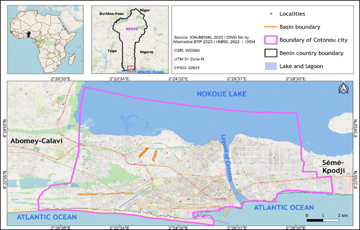
Figure 1
Geographic location of Cotonou city.
Cotonou is subdivided into 13 districts and serves as the economic capital of Benin. Cotonou faces multiple environmental challenges, notably related to rainwater drainage and urban flooding. Climatically, the city of Cotonou experiences a Guinean climate, locally known as subequatorial climate (Adam and Boko, 1993), characterized by the annual succession of four seasons, including two rainy seasons and two dry seasons of unequal duration (Tente, 2010). Cotonou is among the wettest cities in southern Benin, with an average annual precipitation of 1346 ± 307 mm over the last thirty years from (1995–2025) (Météo-Benin, 2025). Monthly average maximum temperatures range from 28.19°C to 32.35°C, while minimum monthly average vary between 24.1°C and 26.8°C (Météo-Benin, 2025). The natural vegetation of Cotonou consists of a mosaic of plant formations whose floristic composition varies according to substrate type and degree of flooding. This ecological heterogeneity supports diverse habitats that are utilized by local populations for multiple purposes, including food, medicine, grazing, and crafts.
The human population of Cotonou has grown rapidly from 320,348 inhabitants in 1979. to 665,100 in 2002 and an estimated 680,012 in 2013 (INSAE, 2013). Projections suggest a population of approximately 1 628 986inhabitants in 2030 (INStaD, 2025).
The empirical focus is on the Cotonou Rainwater Sanitation Program (Programme d’Assainissement Pluvial de Cotonou, PAPC), a major urban infrastructure initiative aligned with sustainable development objectives. Three retention basins targeted by the program were selected as case study sites: Pa2, Pa3, and Aac. The Pa2 retention basin is located in the 10th arrondissement of Cotonou, specifically within the Missogbé and Minonkpo districts. The Pa3 retention basin is also situated in the 10th arrondissement, in the Sètovi district. The AAc retention basin is located in the 12th arrondissement and includes the districts of Fidjrossè Kpota, Fidjrossè Centre, and Houénousou (Figure 2).
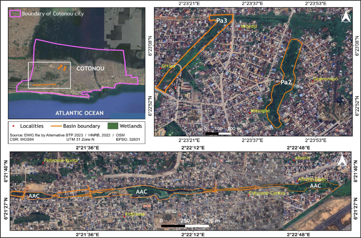
Figure 2
Geographic location of the Pa2, Pa3, and AAC basins in Cotonou.
These basins serve as primary outlets for rainwater toward Lake Nokoué and the Cotonou channeldrainage and constitute important wetland ecosystems that support biodiversity and local livelihoods. The selection of these sites was based on three criteria: (i) their ecological importance, (ii) their role as sources of common-pool resources for local populations, and (iii) their direct exposure to infrastructure development under the PAPC.
Data collection
The methodology used for this study is based on a mixed approach (scientific and socio-anthropological). The data collected on pre-urban common property systems comes from the president of the Community Development Association WXLA and SETTO of Cotonou, neighborhood chiefs, traditional chiefs, customary chiefs and populations living near wetlands. Data relating to avifauna and flora are collected in the field using bird inventory sheets, vegetation survey sheets and survey sheets with local populations in the different basins and collectors. investigated in the city of Cotonou. For mapping and demarcation of avoidance zones, equipment such as GPS receivers, smartphones and tablets equipped with the ODK Collect V1.30.1 and Locus Map 4.2 applications and the DJI Phantom 4 pro V2.0 drone are used. Based on the field survey carried out along the basins, vegetation survey stations were selected mainly taking into account the floristic homogeneity of the vegetation. A total of 29 surveys were carried out in the basins. At each station, flora inventories were carried out by recording both station data and the list of flora species encountered.
For the avifauna inventory, 29 sample points (waypoints) or listening stations were systematically surveyed. The avifauna surveys were carried out both in the terrestrial environment and on the water. Two complementary bird census methods were used. These are inventories by point count and bird captures using mist nets in inaccessible closed environments.
A total of 60 people located in the project areas were interviewed. The information collected from local populations made it possible to establish a list of the different species of flora and water avifauna still present in the different basins.
Furthermore, the collection of data on the mapping of the 3 planned rainwater drainage basins began with the point of the various recent cartographic documents covering the city of Cotonou. An exhaustive inventory of thematic maps available for the city is made at the level of the National Center for Remote Sensing and Plant Cover Monitoring (CENATEL), the National Geographic Institute (IGN) and the PAPC and the IRGIP study office. The second step is the production of vector files (shapefile) in a georeferenced database. This phase consisted of digitizing on screen the digital maps selected during the inventory of cartographic documents. The digitization was carried out using ArcGIS 10.1 software and the vector files obtained are then converted into a kmz file for use in the Locus Map application. In order to have a correct, complete and detailed view of the 3 rainwater drainage basins, drone overflight missions were carried out to collect spatial data on the 3 drainage basins. The drone was deployed for aerial photography in order to take reference images of the state of the plant cover around the 3 basins before the construction of the structures by the PAPC. The drone that was used to acquire aerial images is a DJI Phantom 4 pro V2.0. The collected data were processed and analyzed in accordance with the objectives of the study regarding frequency and frequency use categories.
Results
Local common property institutions
The Xwla came from TADO and passed through several regions before settling in the regions we know today. They emigrated from Tado together with their brothers the Xwéla (Pédah); the particularity of these two socio-cultural communities is that they like to live in lake areas, hence the proximity of the Xwla to the edge of the Atlantic Ocean. The Xwla‘s identity activity is fishing. Agriculture is also noted as a second activity.
The local populations of the wetlands are the first occupants of the city of Cotonou. They are the “SETTO and the HXLA”. They developed their traditions, their cultures and their economies there. They became familiar with the humid ecosystem with all its resources. This leads them to develop strategies for protecting wetlands and the resources associated with them. People continually adapt to environmental and social changes in wetlands. Faced with demographic growth, urbanization, industrial and economic development in the city of Cotonou, the HXLA and SETTO communities are infiltrated by foreigners from Benin and neighboring countries. Thus, we note the presence among these populations of Fon, Adja, Yoruba, Goun, Ahoussa, Jerman, Ibo, Nagot. Furthermore, the social organization of the Hwla and Setto is based on community structures which promote cooperation for resource management. This includes informal governance systems where decisions about land use and resource conservation are made collectively. Wetlands are essential for biodiversity, providing habitat for many animal and plant species. They also play a crucial role in regulating the water cycle, protecting against flooding and filtering pollutants. The Hwla Setto, as guardians of these ecosystems, actively participate in their preservation.
The Seto and Xla were the firstcomers in the area and had established a local institutional setting for the use and management of their common property based on inheritance, donation and lease. Community organizations around these wetlands are led by customary authorities or family heads. These chiefs or customary authorities play the roles of conservators and preservation of the CPRs in their common property. The main activities of these people are agriculture, fishing and livestock breeding. Others invest in crafts and processing products from wetlands. Traditional practices are often based on orally transmitted knowledge and are adapted to the natural cycles of aquatic ecosystems. Furthermore, the different uses revolve around the harvesting of common-pool resources such as plants, fisheries and agricultural lands.
In terms of social organization, there was a coordinator of the commons, who is called ‘king of Setto’ named Kokouè who put things in order. The term king does not refer to feudal powers in the. European sense but rather to his role as coordinator and over viewer of the commons.
In this role he also coordinated the presence of other populations while settling disputes among the local commoners. This Kokouè was succeeded by others until the last coordinator called Agbaffa who reigned in Cotonou until 1951. This system was embedded into local animistic ontologies as from local views the coordinator had deities who assisted him in his role as supreme coordinator. They controlled all forms of common-pool resources, including the populations under the protection of the king. Among these deities we have observed two deities called TOLEGBA. One of the two Tolègba located in Sainte Cécile and the second located in Gboto on the edge of Agblangandan. They are all venerated by the population of Setto even today. Therefore common-pool resources, especially wetlands, are controlled by the king, his deities, their priests and followers. The fishing waters are protected by a deity who is also worshiped by purifying the waters annually.
In addition, certain rules have to be followed: People described as impure are isolated in a neighborhood called LADJI during resource use activities. These are women and men with evil spirits, menstruating women, men with contagious diseases. In the community, no one could go fishing or hunt in the swamp forests areas. Officials were appointed by the king to monitor each area of the territory. While actually being sea fishermen, the Setto and Xla people learned the practice of inland fishing and adapted their fishing tools to the conditions of the lake Nokoué and the Cotonou channel. The fish taken are intended for sale and marketing. The people also practice agriculture. Crops such as oil palm, coconut palm, rice, sweet potato, sugar cane, maize, cassava and vegetables are grown by the people.
It should also be noted that they also raise poultry, small and large ruminants. For several hundred years, the region of South Benin and specifically Cotonou, where the XLA and Setto populations live, has been characterized by a rainy season and a dry season. The region is plagued by recurrent floods resulting in the displacement of populations, the destruction of property and agricultural products with damage to homes. According to the accounts, the water height sometimes reached two (02) meters from sea level. This led to the creation of the Cotonou lagoon, which drains water to the sea to relieve the populations living along Lake Nokoué. But long before that, the Xla and Setto people were developing adaptation strategies that enabled them to overcome the challenges of flooding and water-related diseases.
Characterization and extent of the habitats of the 3 prospected basins
Three land use units (urban area, swamp forests, and swamp meadows) are identified within the 3 prospected basins studied (Table 1).
Floristic diversity of the main types of habitats encountered
During the inventories, seven (07) main plant formations with specific richness and diversity of families (Table 2).
Table 2
Diversity of different plant formations within the 3 retention basins.
| RETENTION BASIN | MAIN PLANT FORMATIONS | SPECIES RICHNESS | FAMILY DIVERSITY |
|---|---|---|---|
| AAc | High thick high marsh medows | 11 | 8 |
| Dense swamp forests | 34 | 17 | |
| Subtotal | 45 | 25 | |
| Pa3 | Swamp forests | 14 | 11 |
| Low marsh medows | 12 | 8 | |
| high marsh medows | 7 | 6 | |
| Subtotal | 33 | 25 | |
| Pa2 | Dense swamp forests | 11 | 8 |
| Dense swamp forests degraded | 16 | 11 | |
| Low marsh medows degraded | 9 | 7 | |
| Subtotal | 36 | 26 | |
| TOTAL | 114 | 76 |
Categories and forms of plant use in the ecosystems of the surveyed basins today
This research conducted with local users of Cotonou wetlands demonstrates the enormous ecological and socio-economic importance of these flood regions. Biological data, which includes information on flora and fauna, reveals the richness of these ecosystems and their crucial role for local communities. To this end, five different forms of use are made of the plant resources of the sites housing the basins. Indeed, the analysis of the data collected shows that the local populations of the localities sheltering the basins use plant resources for food (37%), grazing of domestic livestock (26%), medicine/medico-magic (26%), crafts or wrapping rope or foil (9%), use of firewood (2%). These local populations have used the wetlands for several generations. Around the basin construction areas, 46 plant species are used either for food, for medicine, for grazing or as firewood. The 48 species are divided into 25 families and 34 genera. The most represented families are those of Poaceae with 07 species, those of Arecaceae with 03 species, those of Caricaceae, Combretaceae, Cucurbitaceae, Cyperaceae, Fabaceae, Lamiaceae, Marantaceae, Moraceae, Moringaceae, Musaceae et Typhaceae represented twice in the five categories of use.
Diversity and use of food plants in the prospected basins
Concerning the use of species in food, eleven (11) species are cited by the population. The plants primarily found in the ponds and which are consumed by the populations are Musa spp (36.6%), Elaeis guineensis (29.5%) and Saccharum officinarum (17.4%). The species Carica papaya, Cocos nucifera, Mangifera indica, Moringa oleifera, Terminalia catapa and Vernonia amygdalina on the other hand have a respective citation frequency of 2.7%. For consumption, food plants are used in two main types of form. We distinguish: direct consumption of fruits or seeds with seven (07) species (Musa spp, Saccharum officinarum, Carica papaya, Cocos nucifera, Mangifera indica, Moringa oleifera, Terminalia catapa) and consumption in the form of sauce of which four (04) species for vegetable sauce (Moringa oleifera, Vernonia amygdalina, Ocimum basilicum, Talinum triangulare), one species for seed and oil sauce (Elaeis guineensis). The most used parts are the fruits (52.42%), leaves (45.43%), and stems (2.15%). So,
“Local communities in the surveyed basins depend significantly on the diversity of food plants and legumes for their daily subsistence. These plants are not only essential sources of nutrition, but also cultural symbols deeply rooted in traditional agricultural practices. Each plant has a specific use. These practices show fine adaptation and in-depth knowledge of local agricultural cycles and plant properties” (AGBEFA Noa Fèmi, Son of the King of Setto).
This citation highlights the dependence of local communities on the diversity of common-pool resources such as food plants for their daily subsistence. Each plant with a specific use illustrates an in-depth knowledge of local agricultural cycles and plant properties.
The research indicates that in total, 14 species belonging to 12 families are frequently used in traditional medicine by the local population of PAPC areas. The most represented species are Abrus precatorius (14.1%), Momordica charantia (14.1%), Combretum micranthum (14.1%), and Senna alata (11.7%). The species mentioned by the populations are used in the treatment of 08 categories of pathologies. The most cited are malaria (62%), skin allergies (11%), stomach aches (9%), infections (6%) and blood pressure (5%).
The plant organs most used for making remedies are leaves (73.8%), flowers and fruits 15.2%, bark 4.4%, roots with 3.85% and the use of the whole plant with 2.75%.
The surveys carried out in the study areas made it possible to list 11 species of forage plants belonging to 9 families for grazing domestic animals. The main species mentioned are Sacciolepis africana (26.11%), Ipomoea aquatica (23.15%), Paspalum vaginatum (22.17%), Polygonum senegalensis (7.39%) and Ficus sp (5.91%).
For use in crafts, 4 plant species divided into 4 distinct families are used by the local populations of the PAPC implementation area for packaging and for art objects. Among the four species, two are mainly used to make mats. These are Typha domingensis and Cyperus articulatus. For packaging, the leaves of plant species with a large leaf surface are generally used. This is the case of Musa spp, Thalia geniculata for food packaging.
Perception by local residents of the impacts of the PAPC on the availability of plants and proposal for mitigation measures
The evaluation of the population‘s perception of the probable impacts of the basin development works on the supply services provided by the plants indicates that the construction of the works as part of the implementation of the PAPC will affect the availability of several species’ plants. Thus, after interviews with the populations, it appears that:
“Residents perceive the PAPC as having a negative impact on the availability of local plants. Many reports that some once-abundant plants, such as medicinal herbs and wild vegetables, are becoming increasingly rare. This scarcity causes difficulties for traditional and medicinal uses, exacerbating dependence on imported products and reducing local resilience. Local residents propose mitigation measures such as the creation of protected areas for natural regeneration, as well as reforestation programs with native species to restore the local ecosystem” (AGBEFA Noa Fèmi, Son of the King of Setto).
The citation reveals that development initiatives like PAPC is perceived a sputting in danger local common property institutions and access to common-pool resources and aks for including traditional knowledge and perceptions of local communities. The establishment of protected areas and reforestation programs with native species are essential measures to mitigate the negative impacts of PAPC and ensure the resilience and sustainability of local practices but this also demands recognition of the local commons and its institutions. A participatory and inclusive approach acknowledging local commons in natural resource management is important to balance development objectives with the preservation of local knowledge and practices.
Categories and forms of use of avifauna
Two forms of use of birds are mainly cited by the populations living near the study areas. These are food use and medicinal/medico-magical use. To this end, the study revealed that 90% of the bird species in the three surveyed basins are used by the population for food and only 25% for local medicine. For the capture of these species of birds, hunting is practiced alone or in groups. To capture birds, local populations use traps (23.58%), nets (21.70%), stone throwers (19.81%), hooks (18.87%), traps (11.32%) and guns (4.72%) in case of necessity. Almost all bird species are used by local populations for food. The most consumed parts are meat (43%); followed by heart + lung (29%) and viscera (28%). In local medicine, only 4 species are listed by respondents for therapeutic recipes. These are Tyto alba, Streptopelia senegalensis, Centropus senegalensis and Ploceus cucullatus whose organs are used in the fight against witchcraft, bewitchment, the treatment of asthma, and kidney ailments.
Perception by local residents of the impacts of the PAPC on the availability of bird species and proposal of mitigation measures
Regarding the assessment of the impacts of the PAPC on the availability of bird species, it appears according to local populations that the construction work will contribute to destroying bird habitats and accelerating their disappearance. In fact, 100% of the populations surveyed estimated that the survival of birds depends on the presence of trees and shrubs to make their nests and reproduce. 86% particularly believe that their presence is also linked to the presence of insects and fish, mainly for birds which live close to the marsh areas targeted by the PAPC.
“We are seeing a decline in plant and animal species due to the destruction of natural habitats and disruption caused by sanitation works, with loss of vegetation and changes in aquatic ecosystems as contributing factors” (River, Cotonou).
Regarding measures to limit the disappearance of birds from the city, the populations surveyed generally remained indifferent although they recognized the importance in food and traditional pharmacopoeia.
This shows the importance of improving the level of environmental education of these populations to contribute to the sustainable conservation of birds which fulfill multiple other functions apart from their use in food and traditional medicine. Photos 1 and 2 are those of drone images respectively of the natural rainwater retention basins AAc and Pa2 of the PAPC intervention zone (Figure 3).
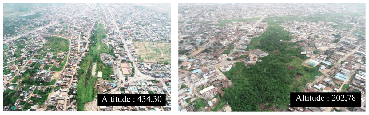
Figure 3
Drone-based imagery of the AAC and Pa2 basins.
Preservation of avoidance zones
In the Pa2, Pa3 and AAc basins, ecological conservation zones were delineated to support the safeguarding of biodiversity and the maintenance of key ecosystem functions. These areas were identified as priority zones for the natural regeneration of plant species and as refuges for wildlife, particularly avifaunal communities, within the broader wetland landscape.
The delineation process relied on the integration of multiple complementary datasets, including floristic and ornithological inventories, socio-economic surveys of local communities, and high-resolution drone imagery. The combined analysis of these datasets enabled the identification of spatial concentrations of biological resources and ecosystem service hotspots across the study basins. This multi-source approach strengthened the robustness of spatial prioritization by incorporating both ecological evidence and local knowledge.
The resulting ecological maps reveal distinct avoidance zones, characterized by relatively high ecological integrity and lower levels of anthropogenic disturbance. These zones are proposed for protection from intensive development or infrastructure expansion in order to maintain their ecological functionality. Importantly, they also contribute to sustaining local resource availability, thereby allowing continued, regulated access to biological resources for surrounding communities.
Beyond their conservation role, these avoidance zones are also expected to function as ecological restoration nuclei, particularly as seed source areas for the natural recolonization of native flora following basin rehabilitation and sanitation activities. In this regard, they represent strategic elements for post-intervention ecological recovery and long-term biodiversity restoration within the urban wetland system (Figure 4).
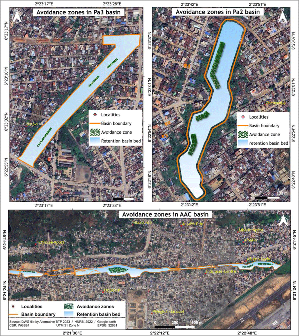
Figure 4
Final delineation of avoidance zones in the Pa3, Pa2, and AAC basins.
Involvement of populations in the preparation, implementation and operation of the works of the Cotonou Rainwater Sanitation Program
Wetland governance in Cotonou involves multiple actors operating across different institutional levels, including national authorities, municipal institutions, technical agencies, and local populations. Survey results reveal variations in stakeholder involvement across the different phases of the Cotonou Rainwater Sanitation Program.
During the preparatory phase, stakeholder participation was limited. A large majority of respondents (88%) reported not being informed about the existence of the program in 2018, while only 17% indicated having received information during the planning stage. Among those informed, 89% reported no direct involvement in any preparatory consultation or decision-making process. Respondents indicated that, although they were aware of a general urban development initiative, specific information regarding wetland management objectives and planned interventions was not clearly communicated.
During the implementation phase, respondents reported increased interaction with program-related governance structures. These included complaint management committees and a Resettlement Action Plan (RAP) implementation committee, as well as environmental and social monitoring committees. These structures were established at multiple administrative levels, including neighborhood, district, and municipal scales.
According to respondents, these committees were involved in awareness-raising activities related to environmental and social issues, monitoring of project impacts, and facilitation of communication between local populations and technical actors. They also contributed to grievance management, conflict mediation, and social intermediation within intervention areas. In addition, both local and technical environmental and social monitoring committees were reported to support activities related to environmental protection, public health, and oversight of project implementation.
Despite the presence of these governance mechanisms, respondents indicated that their involvement was primarily associated with the implementation phase. Local populations were engaged mainly through information exchange, monitoring activities, and complaint management, while participation in earlier stages of the project cycle remained limited.
Overall, the results indicate a governance structure characterized by multi-level institutional arrangements and differentiated forms of stakeholder engagement across project phases, with limited participation during planning and more structured involvement during implementation.
Discussion
Floristic and avian diversity of the species recorded
The present study recorded, a total of 114 plant species and 95 avifauna species belonging respectively to 76 plant families and 39 bird families were recorded throughout the PAPC intervention area. These results highlight the significant biodiversity value of urban wetlands in Cotonou, despite increasing anthropogenic pressures.
Regarding plant diversity, swamp forest exhibited the highest species richness confirming their role as key ecological reservoirs within the study area. This finding is consistent with previous studies conducted in southern Benin, particularly in the Lokoli swamp forest, where high floristic diversity has been reported (Adomou et al., 2009; Dan et al., 2012). These ecosystems, located within the Guinea-Congolian/Sudanian transition zone, are widely recognized for their high biological diversity (White, 1986).
However, the number of species recorded in this study shows variability when compared to other regional and continental studies. While it exceeds the 101 species reported by Hadonou-Yovo et al. (2019) in the Mono Biosphere Reserve and the 36 species identified in urban vegetation studies in Porto-Novo (Lougbégnon, 2013), it remains lower than the 190 species documented in the Mabira Central Forest Reserve in Uganda (Tugume et al., 2016). These differences can be attributed to variations in ecological conditions, land-use intensity, and particularly the high level of urbanization affecting the PAPC intervention area, which contributes to habitat fragmentation and degradation of plant communities.
The relatively high plant diversity observed, despite intense anthropogenic pressures, suggests a certain degree of ecological resilience within these wetland systems. However, this resilience is likely constrained by ongoing urban expansion and hydrological modifications associated with infrastructure development, which may progressively reduce habitat quality and species composition over time.
In terms of avifauna, the recorded species richness confirms the importance of wetlands in Cotonou as habitats for bird diversity. Although the number of species remains slightly lower than the 115 species reported in earlier studies conducted in the city (Lougbégnon and Codjia, 2011), it still reflects a relatively diverse avian community within a highly urbanized environment. The presence of wetland-associated bird species further emphasizes the ecological significance of these habitats for feeding, nesting, and refuge.
Urbanization is known to influence avian diversity by altering habitat structure, food availability, and ecological connectivity. The observed species composition likely reflects both the adaptability of certain bird species to urban environments and the persistence of remnant natural habitats within the study area. In this context, the establishment of avoidance zones within the PAPC framework may contribute to the conservation of avifaunal diversity by maintaining refuge areas within modified landscapes.
Overall, the findings underline the dual role of wetlands in Cotonou as biodiversity reservoirs and urban ecosystems under pressure. The observed patterns of floristic and avian diversity reflect both the ecological importance of these environments and the impacts of anthropogenic disturbances, highlighting the need for integrated management approaches that balance conservation and urban development.
Categories and forms of use of identified plant species
This study identified 45 plant species used by local populations and reports the level of knowledge of plant resources of local commoners on the one hand and highlights the importance of these resources in the daily life of local populations in the area. The influence of the PAPC for the satisfaction of their different needs for food, medicine/medico-magic, grazing of domestic livestock, firewood, crafts or rope or wrapping paper on the other hand. Approximately 80% of the world‘s population uses traditional medicine to treat illnesses and diseases (Singh et al., 2014). In developing countries, the proper use of medicinal species is both a valuable resource and a necessity, as they replace primary health care systems (Jiofack et al., 2010). The recognition of this medicine alongside conventional medicine has been the subject of criticism and discussions which have contributed to delaying the expansion of traditional medicine (Esseh et al., 2019). Except for cultivated plants, several thousand little-known wild plants have nutritional and therapeutic properties (Benem and Sanou-Nana, 2009; Benkhnigue et al., 2010; Effoe et al., 2020). Controversially, if plants are essential to human nutrition and care, several of them, considered wild because they are less cultivated, are threatened with scarcity or disappearance due to food depreciation or actions anthropogenic activities, including urbanization works. In this study, 15 species and 18 plant species are respectively used by local populations in PAPC areas for food and medicinal uses. This low proportion of species used in traditional medicine highlights the state of the plant formations in the PAPC area covered by the study, but also testifies to the importance given to certain plant species in these wetlands for the diet and in the treatment of various pathologies (malaria, skin allergies, stomach aches, infections, tension, etc.). The numbers 15 of food species and 18 of medicinal species inventoried are significantly lower than those recorded by Hadonou-Yovo et al (2019) in the Mono reserve in Benin (35 and 72 species respectively). This could be explained by the fact that the wetlands subject to our study have experienced strong anthropization and very pronounced urbanization. It is appropriate to reserve spaces dedicated to the conservation of these species used by local populations and to prioritize them in reforestation campaigns.
Parts of plants used by local commoners
According to the results of this study, leaves appear overall to be the most used plant organs (45.43% for food use and 73.8% for medicinal use) by the populations of the area covered by the PAPC. These results also corroborate well with those obtained by Hamidou et al. (2015) in work on the use and preference of woody plant species in two classified forests in Niger, Hadonou-Yovo et al. (2019) on the diversity and forms of use of woody species in the Mono Biosphere Reserve in Benin than those found by Singh and 2016 during their work on ethnobotany, traditional knowledge and diversity of plants and fungi wild edibles: a case study in the Bandipora district of the Kashmir Himalayas in India and which mentioned the leaves as the organs most used by the local people. This result could be explained by the fact that food and medicinal uses are mainly focused on the leaves. Other scientific works (Ouro-Djeri et al., 2022; Effoe et al., 2020; Mpondo et al., 2017; Koudouvo et al., 2011) have given similar results and reveal that the leaves have been cited as organs most used in traditional pharmacopoeia. These results could be explained by the fact that leaves constitute the storage location of secondary metabolites responsible for the biological properties of medicinal plant species (Bhattarai et al., 2006). Given that there is a clear relationship between the part of the plant exploited and the regeneration of species (Delvaux et al., 2009; Dossou et al., 2012), the method of collection (the bad practice of populations which instead to take only the desired part, sometimes tearing up the entire plant or breaking the branch) and the intensity of collection on the regeneration of the species, it is therefore important to raise awareness among populations about rational techniques for removing plant organs in order to avoid not undermine the possibility of sustainably benefiting from the services of these resources.
Governance asymmetry and participation gaps
The results reveal a pronounced asymmetry in participatory governance across the different phases of the PAPC program. While stakeholder engagement appears to have increased during the implementation phase through formal institutional arrangements, participation during the planning phase remains highly limited, as evidenced by the widespread absence of early-stage consultation or information among respondents. This pattern reflects a sequential and hierarchical governance configuration in which decision-making is concentrated during the initial design phase, followed by more operational and procedural forms of participation during implementation. Such configurations are frequently observed in environmental and development interventions, where participation is often mobilized as a tool for project facilitation rather than as a mechanism for shared decision-making (Arnstein, 1969; Pretty, 1995; Reed, 2008).
The presence of institutional arrangements such as grievance mechanisms and environmental monitoring committees indicates an attempt to operationalize participatory governance. However, the functional scope of these mechanisms appears largely limited to operational monitoring, feedback collection, and conflict resolution, without substantial redistribution of decision-making power. This distinction between procedural and substantive participation is widely documented in the governance literature, which highlights that participatory structures may exist without necessarily altering underlying power asymmetries (Cooke & Kothari, 2001). In this regard, participation may become instrumentalized, serving implementation efficiency rather than transformative governance objectives.
From a socio-ecological perspective, such asymmetries may have important implications for both ecological outcomes and social acceptance of environmental interventions. The limited inclusion of local ecological knowledge and customary institutions during the planning phase likely constrained the ability of the program to incorporate context-specific resource dynamics. In wetland systems, local knowledge plays a critical role in understanding seasonal variability, resource availability, and sustainable harvesting practices, which are essential for adaptive management (Ostrom, 2009).
The exclusion or marginalization of these knowledge systems can contribute to mismatches between formal management objectives and local livelihood dependencies. As emphasized in socio-ecological systems theory, adaptive and resilient governance depends on the integration of multiple knowledge systems and cross-scale institutional interactions (Folke et al., 2005; Cleaver, 2012). In this sense, governance effectiveness is not only a function of institutional design, but also of the extent to which local practices and informal arrangements are embedded within formal decision-making processes.
Empirically, the observed governance asymmetry provides a plausible explanation for the negative perceptions associated with biodiversity conservation and access to natural resources reported in the study. Similar patterns have been documented in other wetland and natural resource governance contexts, where limited early-stage participation has been associated with reduced legitimacy and lower acceptance of ecological trade-offs (Haller, 2019).
Strengthening participatory processes during the planning phase, rather than restricting engagement to implementation stages—could enhance both the social legitimacy and the ecological effectiveness of wetland management interventions. Integrating customary institutions and local ecological knowledge into early decision-making processes would likely reduce governance asymmetries and improve the alignment between conservation objectives and local livelihood systems.
Conclusion
In this study, ethnobotanical and ethnozoological survey methods, cartographic and statistical analysis methods are specifically used. A participatory and inclusive approach made it possible to collect information from local populations in order to propose management strategies for common pool resources rescued after the development work. Our results reveal that the implementation of the Cotonou Rainwater Sanitation Program will substantially improve the living conditions of populations living near the wetlands of Cotonou. The structures will allow rainwater to be evacuated towards Lake Nokoué and will reduce flooding in the neighborhoods. But despite this aspect offered by the PAPC development work, it appears that the impacts on common-pool resources are enormous. In fact, the wetlands of the basins studied are destroyed by more than 90%, leading to the disappearance of specific faunal and floral species and diversified families. And since these species are used regularly by local populations for several needs (food, traditional health care, crafts, economy and tourism), it is obvious that the populations have managed their commons well face challenges of health, food and local economy if the sanitation project Cotonou Pluvial Sanitation Program (PAPC), justified by the use of the SDGs is put in place without their involvement.
This study offers the possibility of establishing the relationships between development policies and the interests of grassroots populations. It allows us to understand how development policies undermine the interests of the populations of the project intervention areas. It also allows us to understand that there is a conflicting nature between the implementation of the SDGs, if all precautions are not taken by the project preparation and implementation teams.
Faced with these various alarming findings, we propose to involve local commoners of the two ethnic groups with their common property institutions and by perhaps reinstalling their coordinators as well as other co-users in the preparation of any project, taking into account all social strata in order to benefit from their field experience, then to take their interests into account in the implementation. projects. It should also be noted that the populations themselves must encourage themselves to adopt good behavior in order to restore degraded resources. Cases studies on how local discussions can lead to local bottom-up institutions building could be for example in fisheries and forestry and leading to a process called constitutionality show that what is needed is process, which is not guided by top-down developed sustainability goals a real participatory process, which is also really inclusive (see Haller et al 2016). In this way awareness and also a sense of ownership of new rules managing the wetlands and its common-pool resources is possible.
Cotonou wetland communities, development of traditional practices with ancient rules, inherited from their tradition to protect common pool resources. These practices are unfortunately ignored in the context of urban infrastructure development. In addition, a process of community participation in the maintenance of the infrastructure built, and the preserved natural habitats is underway. The project unit has set up local environmental and social monitoring committees and a non-governmental organization platform to ensure the protection of the remaining common pool resources.
Acknowledgements
The authors would like to express their sincere gratitude to all local communities, customary authorities, and stakeholders who generously shared their time, knowledge, and experience during the field surveys. Their invaluable contributions greatly enhanced the quality and relevance of this research. We also acknowledge the support of the institutions and organizations involved in the implementation of the Cotonou Rainwater Sanitation Program (PAPC) for facilitating access to information and study sites. Special thanks are extended to the field assistants and collaborators who contributed to data collection, ecological surveys, and spatial analysis. Finally, the authors appreciate the constructive comments and suggestions from reviewers and colleagues, which helped improve the quality of this manuscript.