
Introduction
Mapping is not a neutral act (Corner, 1999; Crampton & Krygier, 2006). It is a propositional and political practice that actively constructs space, often through what this paper calls cartographic violence: the epistemic and structural violence by which maps define “who or what exists and in what order” (Akerman, 2017; Craib, 2017). Maps have historically served as instruments of domination, erasure, and dispossession (Stone, 1988; Dieckmann, 2021; Remy, 2018). Critical cartography critiques “cartographic naturalism,” arguing that maps are inscriptions that are produced by actors, instruments, and institutions which create rather than mirror reality (Corner, 2011; Crampton & Krygier, 2006; Wood, 1987). In colonial contexts, mapping became a tool of sovereignty and administration, imposing legal-institutional regimes over land and populations (Neocleous, 2003). This imposition often displaced and silenced local knowledges, institutionalizing forms of spatial inequality that persist today (Dieckmann, 2021).
In Kenya, the colonial cadastral map exemplifies these dynamics. Emerging from the 1886 Berlin Conference and subsequent British administration, mapping did not merely delineate borders, it restructured land relations to facilitate dispossession (Boone et al., 2021; Ciekawy, 1988; Prior, 2012). The Cartesian grid imposed an abstract territorial logic that erased relational geographies, replacing communal tenure systems with surveyed parcels under state control. In the coastal region, British maps rendered Mijikenda settlements invisible, reinforcing the colonial fiction of terra nullius and legitimizing appropriation (Boone et al., 2021). Borders such as the 10-mile coastal strip shown in Figure 1 below, prepared by the British colonial administration and formally recognizing the Sultan of Zanzibar’s dominion, entrenched spatial hierarchies, privileged coastal elites and restricted hinterland communities’ movement, land rights, and resource access (Boone et al., 2021; Stone, 1988).
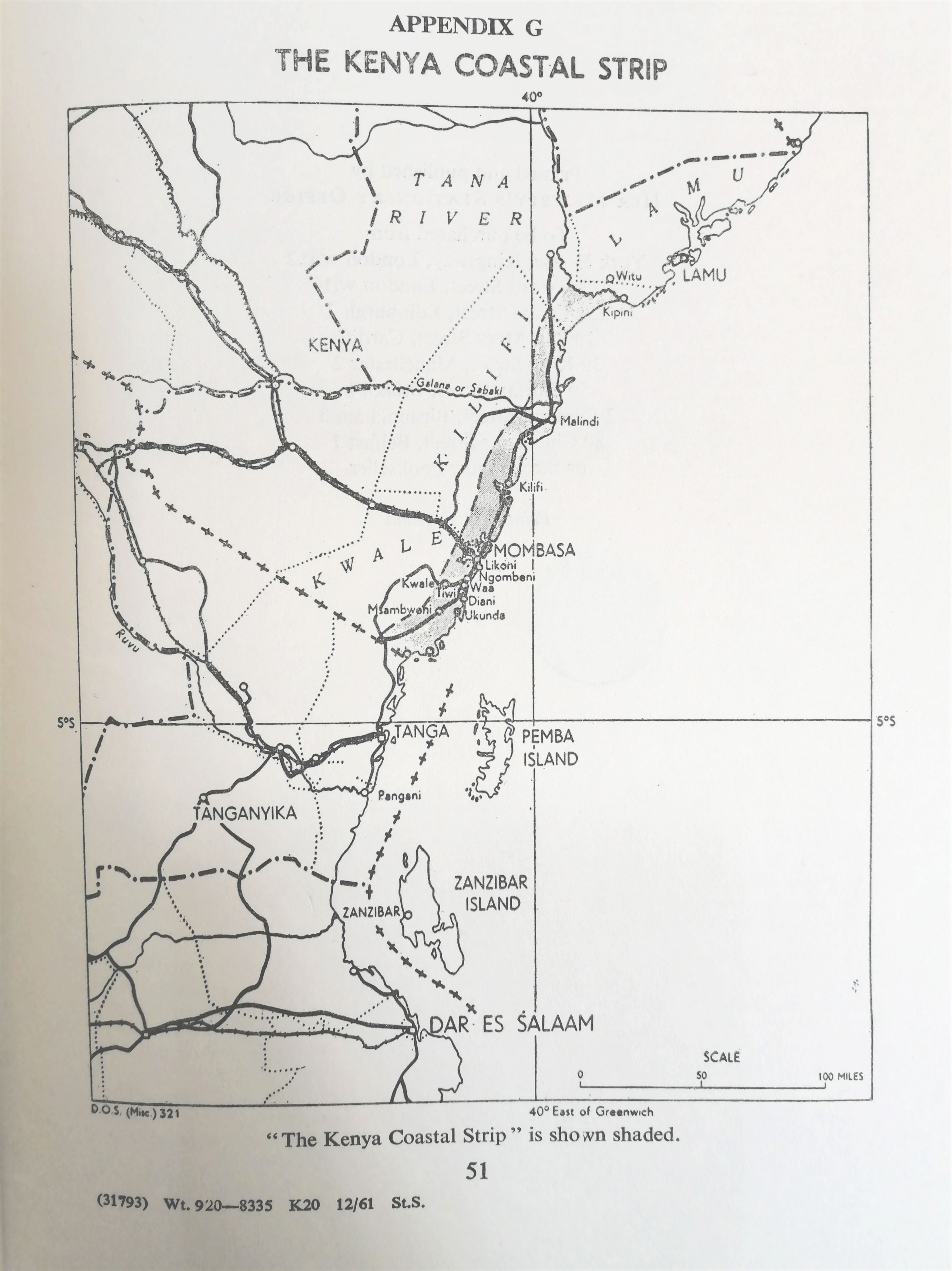
Figure 1
A map showing the former Kenyan Coastal 10-mile strip drawn by the British colonial administration that formally recognized the Sultanate of Zanzibar dominions. Source: British Museum.
Here, cartographic violence operated on multiple levels. Epistemically, colonial mapping overwrote Indigenous spatialities, oral geographies, sacred landscapes, and fluid territorialities with European cadastral logics standardized for extraction and control (Stone, 1988; Neocleous, 2003; Papillon, 2009; Watson, 2009). Structurally, it institutionalized regimes that restricted access to land, infrastructure, and decision-making, perpetuating poverty and exclusion (Papillon, 2009; Watson, 2009). These maps created borders and property regimes treated as immutable “facts,” masking their origins in political and military conquest (Craib, 2017). Even in post-colonial contexts, these boundaries are naturalized, foreclosing alternative arrangements that could accommodate Indigenous claims (Craib, 2017). Such spatial orders are sustained in post-independence Kenya, where state-led mapping remains tied to what Ngũgĩ wa Thiong’o (1987) terms “fatalistic logic,” reproducing colonial spatial ontologies that marginalize plural and embedded ways of knowing (Thiong’o, 1987). The state, as the principal cartographic authority, continues to render territories legible to the needs of governance and markets (Dieckmann, 2021; Scott, 1998), perpetuating an ideological conflict with communities whose spatial practices are dynamic, negotiated, and embedded in place.
Hegemonic mapping is therefore both an instrument and a symptom of deeper power structures. It organizes territories into fixed configurations that privilege the authority of the map’s authors while legitimizing specific claims to space (Corner, 1999; Crampton & Krygier, 2006; Wood, 1987). Rooted in Western property regimes, it draws static boundaries that fragment shared ecological and cultural commons, reinforcing Hardin’s “tragedy of the commons” narrative (Harvey, 2011). Alternative mapping practices, particularly participatory and counter-mapping, have sought to contest the authority and authorship of hegemonic cartographies by making marginalized communities visible. These approaches challenge spatial exclusion and create platforms for more just representation. This paper examines inclusive and participatory approaches to alternative mapping that challenge the ontological and epistemological foundations of hegemonic cartography in Coastal Kenya. It asks to what extent, and under what conditions, does counter-mapping facilitate or align with (re)commoning processes, given that counter-mapping embodies the fluid, adaptive nature of (re)commoning, which resists static representation.
Here, the terms commons, commoning, and re-commoning are used interchangeably to describe interconnected processes and realities. The commons refer to lands collectively managed through customary practices, contrasting with state-centric perspectives that reduce them to mere “common lands.” Following Linebaugh (2008) and Bollier and Helfrich (2019), commoning is understood as the active, collective practice of mobilizing local knowledge systems to create solidarity-based forms of governance and sustainable land use (Linebaugh, 2008). These practices are grounded in a relational ontology (Segers et al., 2013) that recognizes human–nature interdependence, resisting extractivist and privatizing logics embedded in colonial legal and political traditions. The state’s ongoing discommoning (Linebaugh, 2008) is a process of enclosure and commodification that undermines such relations, often through the mechanisms of mapping. In response, re-commoning emerges as a counter-process in which communities reclaim spatial narratives, reassert collective responsibility, and revitalize socio-spatial arrangements grounded in reciprocity and ecological stewardship.
However, critical cartographers note that many participatory projects emphasize “praxis over theory”, failing to confront the underlying ontological and epistemological foundations of hegemonic mapping (Dieckmann, 2021; Paez, 2019; Schranz, 2021). In immobilizing transient, relational knowledges, they risk reproducing the very exclusionary logics they aim to dismantle.
This paper positions counter-mapping not simply as a participatory exercise, but as a potentially transformative practice capable of confronting cartographic violence and re-writing spatial ideologies inherited from colonialism. Through a case study in Coastal Kenya, it examines the conditions under which counter-mapping aligns with (re)commoning processes to support spatial justice and collective governance. In doing so, it engages with mapping as a performative, relational practice (Kitchin, 2001, 2008; Kitchin & Dodge, 2007) that does not merely depict space, but actively shapes the socio-spatial realities in which communities live and govern themselves.
Theoretical Framework – Counter–mapping as a (Re) Commoning Process
Critical cartography offers a framework for rethinking mapping beyond its hegemonic, state-centred traditions. Within this field, counter-mapping as first articulated by Peluso (1995) emerged as a practice through which marginalized and Indigenous communities appropriate cartographic tools to challenge dominant spatial narratives, assert territorial claims, and re-inscribe erased geographies (Peluso, 1995). Peluso (1995) described counter-mapping as the strategic redeployment of the very techniques used to dispossess communities, such as cadastral surveys and topographic maps which produce representations that reflect local understandings and claims to space (Peluso, 1995). Since then, the concept has evolved to encompass a broader set of critical, participatory, and decolonial mapping practices (Harris & Hazen, 2006; Hodgson & Schroeder, 2002).
Counter-mapping destabilizes the epistemic authority of hegemonic maps, which have historically served as instruments of exclusion, and reclaims mapping as a tool for collective agency. Hodgson and Schroeder (2002) emphasize that counter-mapping is not solely about redrawing boundaries; it is a political process that strengthens community cohesion, mobilizes collective identities, and challenges the ontological assumptions embedded in state cartography (Hodgson & Schroeder, 2002). Harris and Hazen (2005) extend this by highlighting the interplay between the map as a visual product and mapping as a social process (Harris & Hazen, 2006). Roth (2009) further notes that the value of counter-mapping lies not only in the maps produced but also in the relationships, alliances, and discourses it generates (Roth, 2009). In its most generative form, counter-mapping aligns closely with the concept of commoning. (Re)commoning refers to the active, collective process of reclaiming and stewarding shared resources through locally grounded knowledge systems and solidarity-based governance (Bollier & Helfrich, 2019).
Both counter-mapping and (re)commoning are insurgent social practices that re-imagine and reconfigure social, ecological, and territorial relations around democracy, interdependence, and self-organization. They mobilize bottom-up practices capable of federating into collective political influence (Mattei, 2016; Ostrom et al., 1999) while resisting extractivist and individualist logics embedded in state–market governance. By bringing these two strands of literature into direct conversation, this paper advances the theoretical position that counter-mapping should not be seen solely as a representational strategy of resistance, but as a processual act of (re)commoning, an active means of reclaiming, governing, and sustaining shared spaces.
Within this study, counter-mapping operates on three interconnected levels. First, it functions as a critical visual engagement, making visible the power structures, exclusions, and spatial inequalities embedded in dominant cartographies, addressing what Schuurman (2000) identifies as the hidden ideological work of mapping technologies (Schuurman, 2000). Second, it acts as a form of epistemic reclamation (Mignolo, 2009), enabling the articulation of counter-narratives that affirm identity, memory, and local ecologies, echoing Rambaldi’s (2006) argument that mapping can serve as a vehicle for cultural survival (IFAD, 2009; Rambaldi et al., 2006). Third, it serves as a political and performative act, creating spaces for spatial negotiation, collective affirmation, and solidarity-building, resonating with Garret-Petts et al. (2015) on mapping’s role in fostering cultural resilience and community-led innovation (Garrett-Petts et al., 2015). This three-level framework integrates counter-mapping’s representational, epistemological, and political dimensions, offering an analytical tool for understanding how mapping can address spatial inequalities, dismantle hegemonic territorial logics, and cultivate community-led governance of commons.
The transformative capacity of counter-mapping lies in its ability to repurpose the propositional power of maps. As Corner (1999) and Wood et al. (2010) argue, mapping is never neutral (Corner, 1999; Wood, 2015; Wood et al., 2010). It stages visions of reality that serve specific interests. By embedding counter-mapping within a commoning framework, this paper reframes mapping as a relational, performative practice capable of transforming socio-spatial orders (Kitchin, 2008). This reframing moves counter-mapping beyond oppositional politics toward a generative praxis that enacts new spatial ontologies grounded in reciprocity, plurality, and collective stewardship. By appropriating the tools of hegemonic mapping, communities can disrupt exclusionary territorial logics, reclaim erased histories, and assert place-based claims. This process is not merely about replacing one representation with another; it involves unsettling the epistemological foundations of what is considered legitimate spatial knowledge.
In the context of Coastal Kenya where colonial and post-colonial mapping practices have long marginalized Indigenous spatialities, counter-mapping as (re)commoning reclaims not only land and resources but also the authority to define, represent, and govern space according to collective values and ecological reciprocity. It is not simply about producing alternative maps; it is about remaking the very conditions under which space, maps and mappings are known, shared, and governed.
Methodology- A participatory and reflexive approach
This research employed a participatory and reflexive counter-mapping approach to examine mapping as a critical visual, epistemological, and decolonial practice. The case study site, Mida Creek, is a confluence of ecological, historical, cultural, land, and urban commons situated along the northern Kenyan coastline, approximately 112 km north of Mombasa and 42 km south of Malindi as shown in Figure 2 below. It includes the Arabuko Sokoke Indigenous Forest that is Africa’s second most important forest for bird conservation after the Congo rainforest, covering 420 square kilometres and gazetted as a crown forest under British colonial administration in 1932 (Mbuvi et al., 2018). Adjacent to the forest lies a mangrove ecosystem within the Watamu Marine Protected Area, functioning as a vital biodiversity corridor linking the sea and forest. These overlapping landscapes form a dense web of commons deeply intertwined with histories of enclosure, restricted access, and contested governance. Fieldwork was conducted in close collaboration with members of the Giriama community as shown in Figure 3 below. The participatory mapping process sought to move beyond official cartographic representations by centring local voices, knowledges, and place-based narratives. Community members identified culturally, ecologically, and socially significant sites through home visits, group discussions, and transect walks, which were then integrated into co-created maps. These mapping sessions became spaces where community perspectives could guide the process, enabling maps to serve not merely as records of territory but as living documents of collective memory, cultural values, and aspirations for the future.
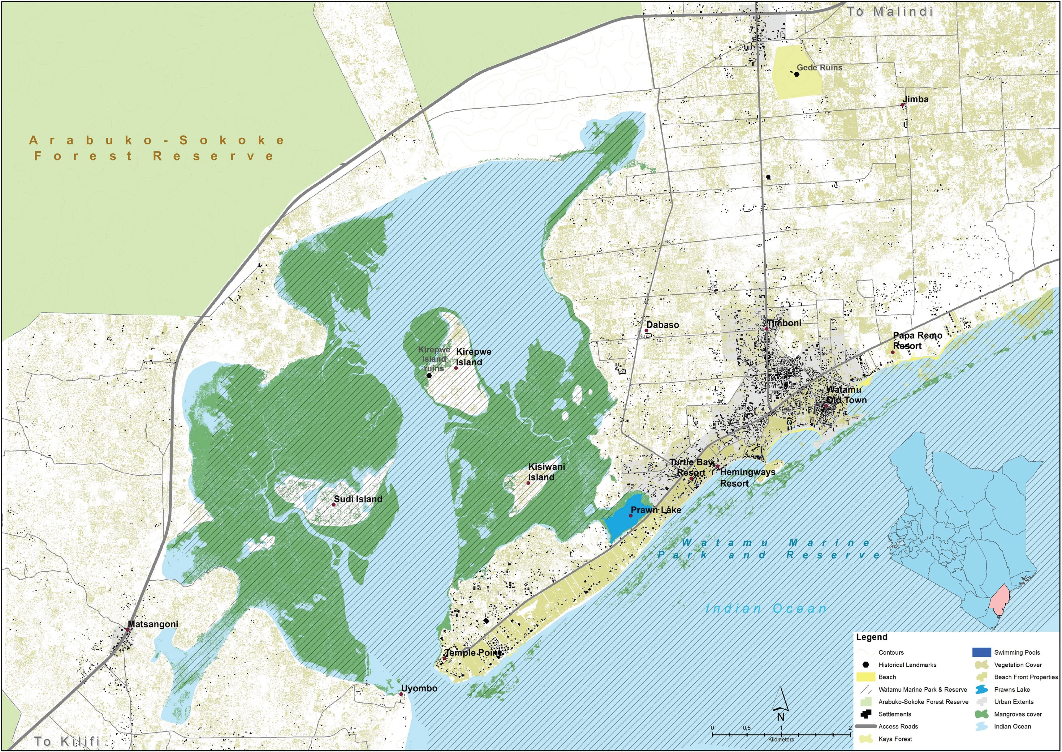
Figure 2
Map of the case study area Mida Creek showing the indigenous Arabuko-Sokoke forest reserve to the top left corner and the adjacent mangrove forest ecosystem that is within the Watamu marine park and reserve. Authors (December 2022).
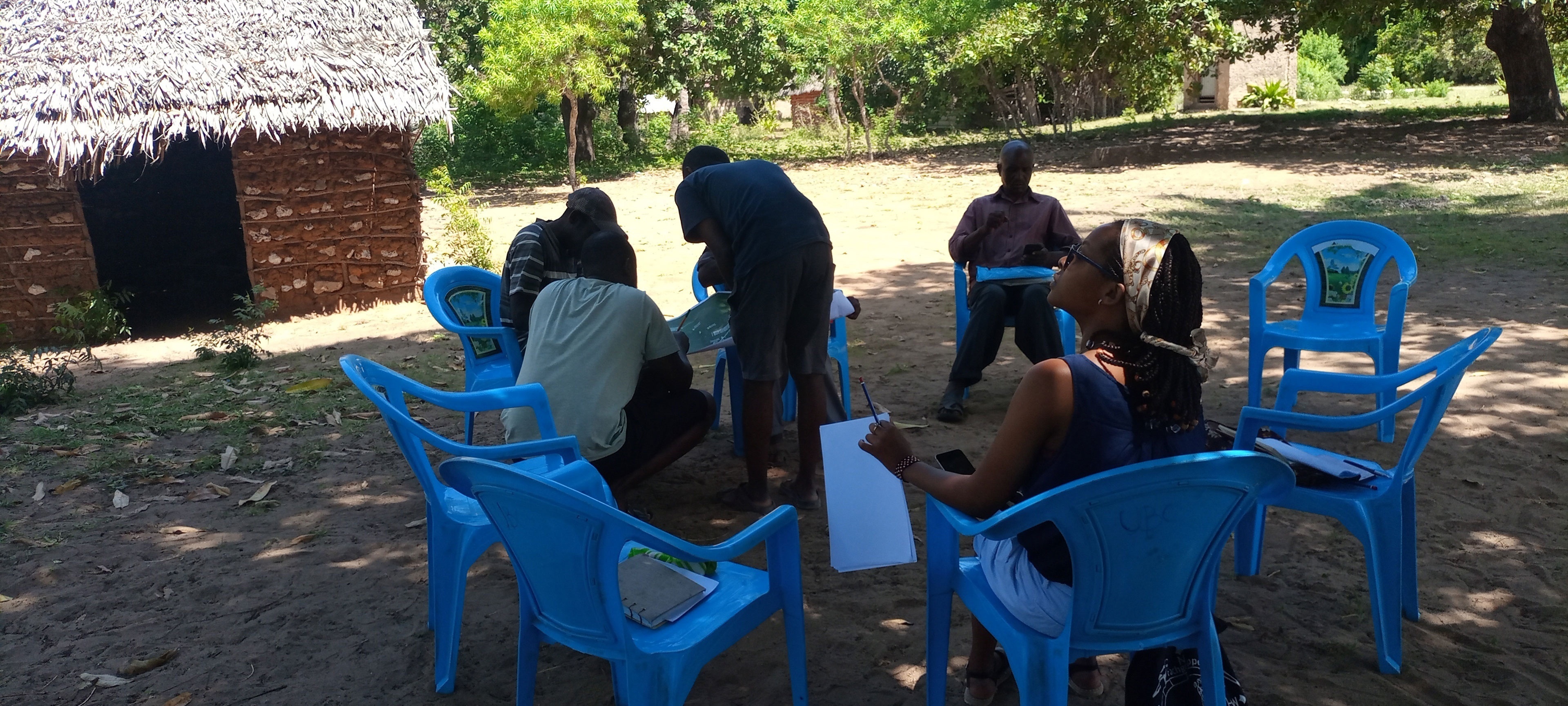
Figure 3
The authors engaging in participatory mapping during fieldwork surveys around the Mida Creek area, Source Authors 2022.
Digital tools, such as the KoboCollect app (KoboToolbox, 2022), were used to record and map nineteen local organizations involved in managing shared natural resources as shown in Figure 4 below. These data were situated within a broader understanding of Giriama and wider Mijikenda customary land practices and governance systems. The resulting outputs took the form of caricature maps that are deliberate artistic departure from conventional cartographic norms. By exaggerating certain features, distorting scale, and using local iconography, caricatures invert the presumed neutrality of the map and offer a playful form of epistemic resistance. In this case, they not only lampooned dominant spatial logics but also foregrounded subjectivity and positionality of the researchers and that of the participants, thereby questioning whose perspectives are legitimized in mapping.
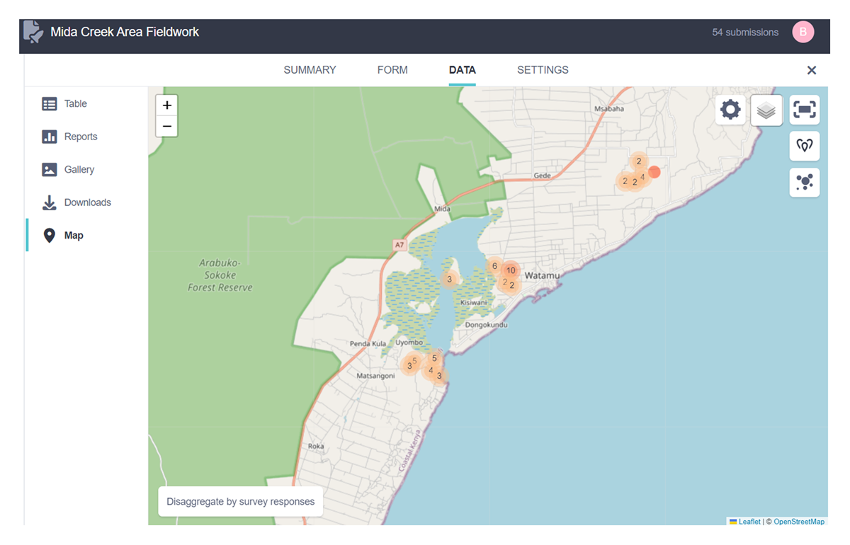
Figure 4
Map showing the spatial distribution of nineteen Community-Based Organizations and household survey data collected using the KoboCollect mobile data collection application (KoboToolbox, 2022). Source: Authors, 2022.
The participatory mapping process was complemented by extensive archival research in both Kenya and Europe. Archival collections consulted included the British Library Map Collection (London), Leiden University Centre for African Studies (Netherlands), KU Leuven Central Library Special Maps Collection (Belgium), the Survey of Kenya archives (Nairobi), and digital repositories such as the David Rumsey Map Collection, Hathi Trust Digital Library, and Library of Congress catalogues. These historical sources helped trace the agency of maps in producing the spatial configurations of Coastal Kenya that revealed the persistent epistemic inequalities in cartographic authorship and custodianship. The fact that many key archival resources remain housed in European institutions, often inaccessible to researchers in the Global South, underscores ongoing imbalances in the ownership and interpretation of cartographic knowledge.
Alongside participatory and archival strands, the research employed interpretative mapping as a reflexive practice. These interpretative maps emerged from specific “mapping moments” in the field, visualizing relational readings of the territory that are often absent in conventional maps. They included annotated diagrams, photo-collages, and speculative cartographies that foregrounded interconnections between cultural, ecological, and historical layers. This reflexive approach made explicit our positionality and biographies as researchers and urbanists, using mapping both as a means of engagement and as an interpretative lens and not only as a method. A further methodological layer was provided by thick description mapping, inspired by Clifford Geertz’s (1973) anthropological concept of thick description (Geertz, 1973). This approach embedded spatial representations within their wider socio-historical, ecological, and political contexts, revealing the interplay between governance structures, land tenure systems, historical legacies, and local knowledge systems in the production of spatial realities. Thick description mapping allowed the research to move beyond surface-level representation, making visible the nuanced ways in which mapping practices are shaped by, and in turn shape, socio-spatial relations.
While participatory mapping in Mida Creek created powerful spaces for community-led representation and provided alternative narratives to dominant cartographies, it also carried important limitations. Participation was inevitably shaped by local hierarchies, with some voices, such as those of elders or community leaders, more prominent than others, potentially marginalizing youth, women, or less vocal participants. The co-production process also relied on our facilitation as researchers, which introduced asymmetries in decision-making over what was mapped, how it was represented, and what meanings were foregrounded. Further, translating complex and often fluid local knowledge systems into static cartographic form risked losing their dynamism, reducing lived spatialities to fixed points or boundaries. These challenges underscore the need for reflexivity in participatory mapping, acknowledging its partiality and the inevitable negotiation between representation, interpretation, and power.
By combining community-led mapping, archival research, interpretative cartography, and thick description mapping, this methodology sought to democratize spatial representation, situate it within longer histories of cartographic power, and generate alternative forms that are as much about relationships and processes as they are about geographic information. In doing so, the research treated mapping not only as a method for gathering data but as an active site of theorizing, one that enacts, rather than simply describes, the possibilities of counter-mapping as a (re)commoning practice.
Results and Discussion
A History of Enclosure Through Hegemonic Mapping
The history of Mida Creek is a layered narrative of access, enclosure, and alienation, one that has been continuously reshaped by successive mapping regimes. Each regime did not simply depict space but actively reconstituted it, embedding political and economic orders that altered the Giriama’s relationship to their commons. To visualise this genealogy of dispossession, the research uses four historical caricatures (Figures 5, 8). These caricatures are rendered in grayscale as a deliberate interpretive device: black signifies periods of significant Giriama access and oversight over their commons, while white represents moments of deep alienation through external control. The gradient between them symbolises contested spaces where multiple spatial orders coexisted and overlapped. This visual strategy is itself a form of counter-mapping. It reframes archival material—maps, records, and histories through a critical visual epistemology, using distortion, contrast, and composition to foreground the dynamics of enclosure that conventional cartography often obscures. By situating each caricature in both historical and cartographic terms, the research mobilises thick description mapping to interpret each period as a spatial process, not just a historical fact.
Quadrant I (11th–16th centuries): Coastal stone towns and early hegemonies
In the first quadrant (Figure 5), Mida Creek appears within the broader network of Swahili coastal stone towns, such as Gede and Kirepwe Island, thriving as key nodes in the Indian Ocean trade (Kirkman, 1957; LaViolette, 2008). Occupied by Omani Arabs, these towns represented early centres of hegemonic influence. The stone towns were urban, cosmopolitan settlements with strong Islamic cultural and legal frameworks, including freehold land ownership and active participation in the slave trade (Kirkman, 1957). This contrasted sharply with Giriama traditions, in which land was communally owned, its use negotiated among households, and governed through Kaya councils of elders (Mutoro, 1985; Waaijenberg, 1993). The Giriama primarily lived inland within coastal ridge forests, practising shifting cultivation cycles of 5–10 years and maintaining sacred forest settlements (Waaijenberg, 1993). The counter-mapping visualisation exaggerates the presence of these towns against the dark expanse of Giriama commons. The white nodes of the towns appear as bright intrusions, signalling the ideological and spatial disruption they introduced. This framing resists the neutral, dotted symbols used in archival maps, instead highlighting them as catalysts for a property regime that would later erode communal tenure.
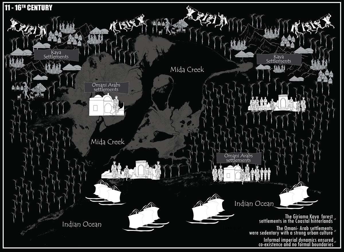
Figure 5
A historical caricature showing the informal imperial dynamics evident in Mida Creek area during 11–16th century. Source: Authors, 2024.
Quadrant II (late 16th–early 19th centuries): Plantation expansion and religious conversion
The second quadrant (Figure 6) depicts the inland spread of Islamic property law through the establishment of coastal plantations, growing coconut and cereal crops for both local consumption and export (Chami, 1998; Githige, 1986; Waaijenberg, 1993). These plantations, governed by Islamic freehold tenure, expanded beyond the stone towns into adjacent coastal lands (Fleisher, 2010). The spread of this tenure regime often meant that land access was conditional upon conversion to Islam, a pragmatic decision for many Giriama seeking to maintain proximity to fertile lands and trading opportunities (LaViolette, 2008; Mutoro, 1985). This was not only a spatial transformation but a social and cultural one, as the terms of belonging and access became tied to a religiously inflected property ideology.
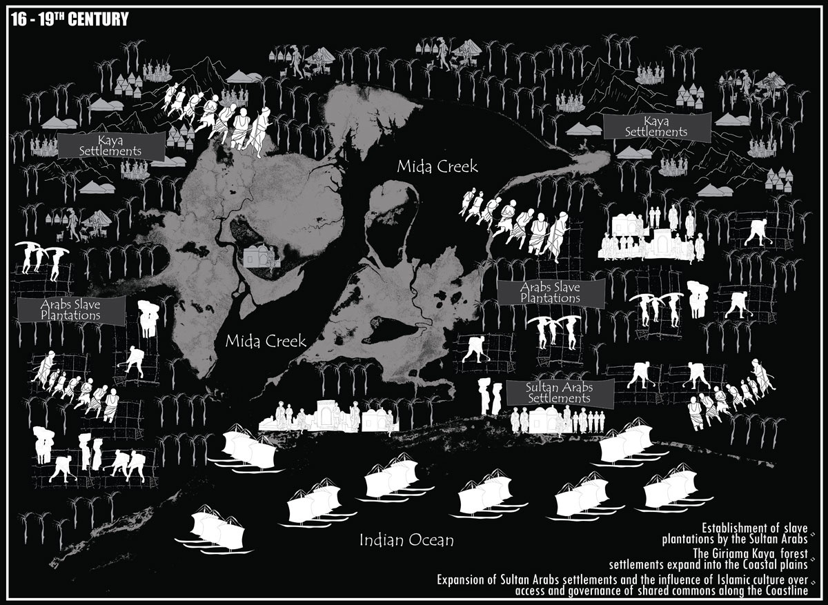
Figure 6
A historical caricature showing the informal imperial dynamics evident in Mida Creek area during 16–19th century. Source: Authors, 2024.
Here, the counter-mapping of plantation boundaries are deliberately overdrawn and shown bleeding into the darker hinterlands, representing the creeping penetration of new tenure rules into communal landscapes. The gradient between plantation white and hinterland black marks the contested edges where communal and private systems overlapped. Archival maps tended to present these expansions as clean, surveyed lines; here they are visualised as porous but relentless incursions.
Quadrant III (19th–20th centuries): The Baratum Line and codification of spatial violence
The third quadrant (Figure 7) shifts to the formal colonial period, beginning with the 1886 Berlin Conference and the British recognition of the Sultan of Zanzibar’s dominion over the 10-mile coastal strip, formalised as the Baratum Line (Bresnahan, 2018; Kanyinga, 2000; Prior, 2012). This arbitrary boundary that was drawn without consultation with local communities (Hamid, 2000) divided the coast into two governance zones: coastal lands under Islamic influence and hinterlands under British control. For the Giriama, whose territories straddled these zones, the Baratum Line was more than a border; it was a mechanism of dispossession. The 1908 Land Titles Ordinance adjudicated land ownership within the 10-mile strip to Arab and European elites, classifying Giriama residents as “squatters” in their ancestral lands (Ciekawy, 1988; Hamid, 2000; Kanyinga, 2000; Mutoro, 1985). Subsequent land adjudications relied on cadastral mapping that was demarcating plots with geometric precision while ignoring customary governance (Kanyinga, 2000). The counter-mapping of this quadrant reframes the Baratum Line as a wound across the landscape. Instead of the clean, straight line of the colonial survey, the caricature renders it jagged and dissonant, cutting through forests, rivers, and settlements. This distortion communicates the dislocation and fragmentation it imposed, challenging the archival portrayal of the line as a rational administrative division.
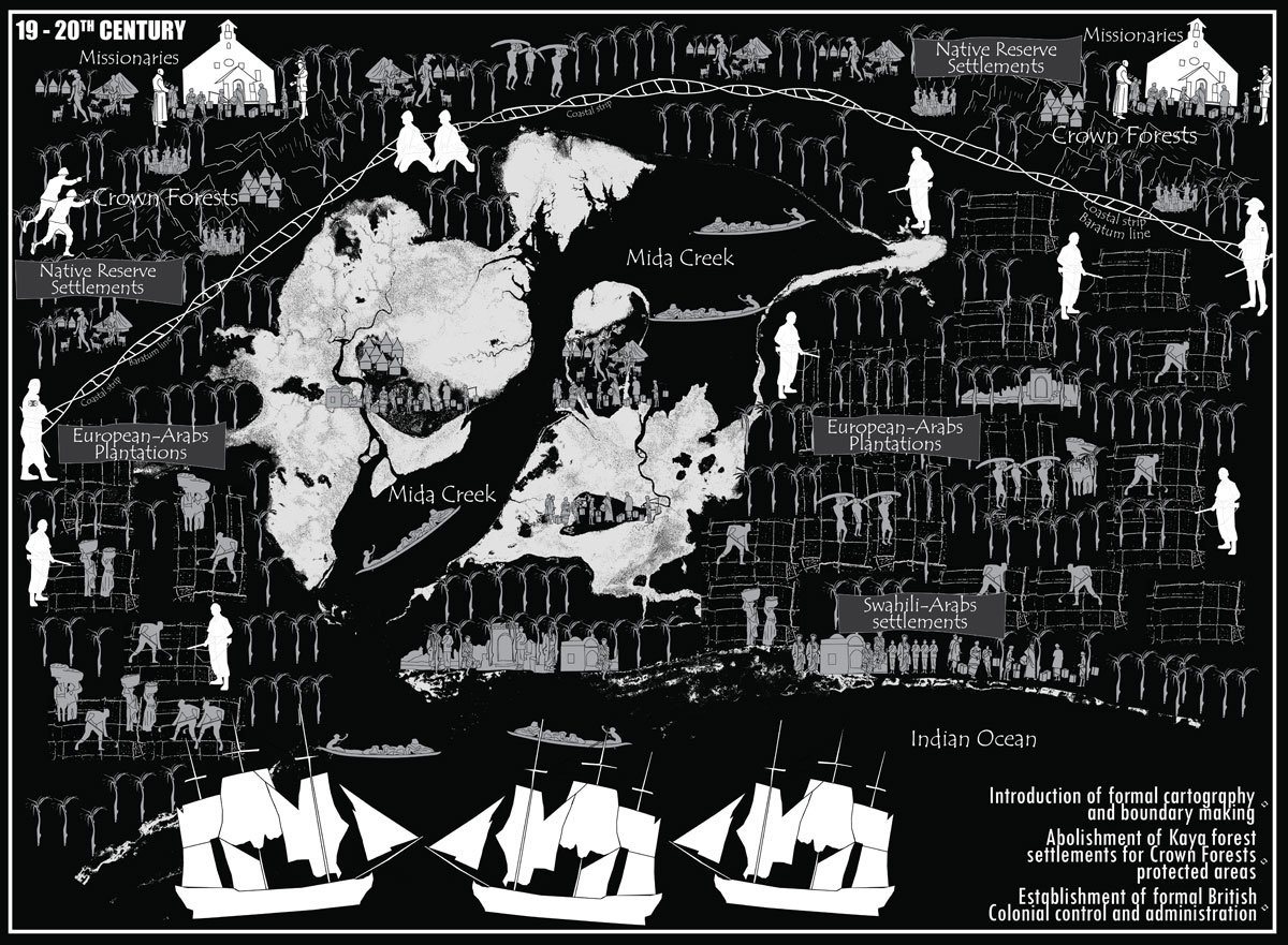
Figure 7
A historical caricature showing the informal imperial dynamics and formal colonial control evident in Mida Creek area during 19–20th century. Source: Authors, 2024.
Quadrant IV (1960s–present): Postcolonial continuity and cadastral entrenchment
The fourth quadrant Figure 8 reveals that independence in 1963 did not dismantle the colonial cartographic order. The new Kenyan state retained the cadastral map as the central tool of land governance, inheriting both its technical form and its ideological assumptions. Post-independence settlement schemes, such as the “1 million-acre” programme, sought to formalise land ownership but often reinforced existing inequalities (Ciekawy, 1988; Kanyinga, 2000; LaViolette & Fleisher, 2018; Shanguhyia, 2021). Absentee landlordism persisted, and bureaucratic registration systems marginalised customary tenure, leaving many Giriama without formal titles (Shanguhyia, 2021). The cadastral system that is rooted in European legal doctrines remained in direct conflict with communal tenure’s fluid and relational logic. In this counter-mapping, the cadastral grid overlays the entire landscape, its lines thick and oppressive. Unlike the neutral, thin lines of official surveys, these exaggerated boundaries convey the weight of legal and bureaucratic authority. They also symbolise how postcolonial governance has continued to fix space into rigid, alienating parcels, perpetuating the enclosures initiated under colonial rule.
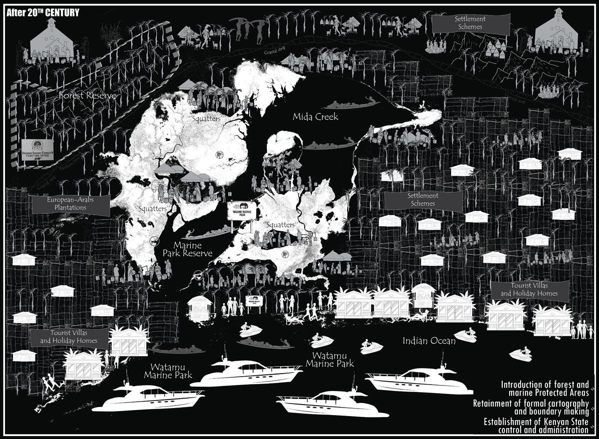
Figure 8
A historical caricature showing the formal colonial and post-colonial dynamics evident in Mida Creek area after the 20th century. Source: Authors, 2024.
Reading the quadrants together: counter-mapping as historical reclamation
When seen together, the four settlement systems present a visual and analytical arc of transformation in Mida Creek as shown in Figure 9, from the embedded cultural commons of the Kaya Forest Settlements to the fragmented and bureaucratically managed landscapes of the Settlement Schemes (Boone et al., 2021) that comprises most of the settlements scapes of Mida Creek area. Rather than a neutral chronology, this sequence is a counter-mapping of enclosure: reframing archival and oral histories through a Giriama-centred lens to foreground Indigenous spatial logics, their gradual erosion, and the continuity of external impositions. In the Kaya Forest Settlements System, all land was held communally, owned by God, and inalienable (Waaijenberg, 1993). Access was negotiated by councils of elders (Enyettsi) according to household needs and productivity. The sacred separation of settlement from cultivation fields, coupled with shifting cycles of 5–10 years, embedded agricultural practice within ecological stewardship (Waaijenberg, 1993). This arrangement exemplified a Giriama ontology in which land was both spiritual and social capital, not a commodity.
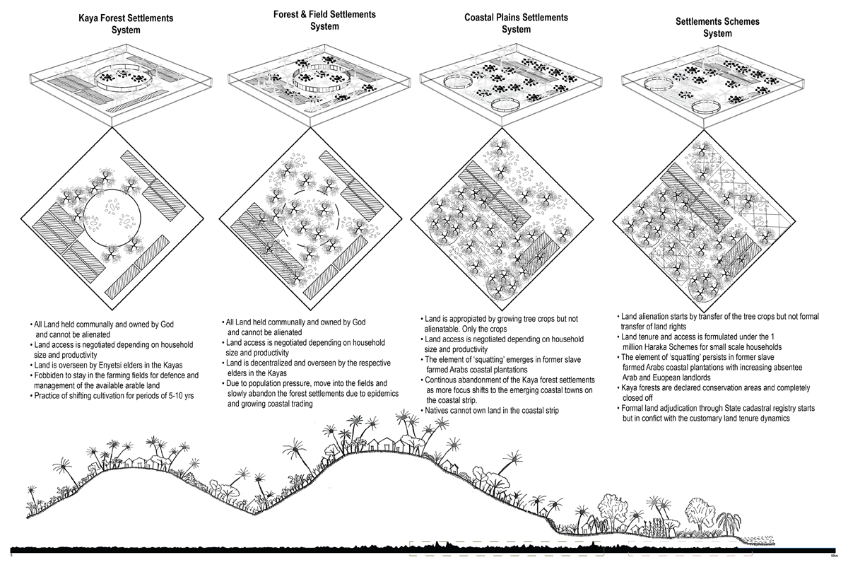
Figure 9
Illustration showing the transformation of the Giriama Kaya settlements commons to the post-colonial settlement schemes. Source: Authors, 2023.
The Forest & Field Settlements System emerged as population growth, epidemics, and expanding coastal trade encouraged dispersal from the fortified Kayas into cultivation fields (Mutoro, 1985). While elder oversight and communal ownership persisted, decentralisation diluted the spatial and defensive logic of the original Kaya form. This shift marks the first internal reconfiguration of the commons, one driven by adaptive pressures but still rooted in customary governance (Mutoro, 1985; Parkin, 1989; Waaijenberg, 1993). The Coastal Plains Settlements System marks a turning point in which external tenure systems penetrated the commons. Land began to be appropriated through the cultivation of tree crops, especially in former Arab slave plantations, without transferring land rights to Indigenous inhabitants (Ciekawy, 1988; Kanyinga, 2000; Waaijenberg, 1993; Willis & Gona, 2013). Legal restrictions barred native ownership within the 10-mile strip, codifying racialised access and pushing Giriama tenure claims into the legal category of “squatting” (Shanguhyia, 2021). The continued abandonment of the Kaya ridges was not simply voluntary migration but a strategic positioning within emerging market economies, albeit one that deepened exposure to exclusionary land regimes.
The Settlement Schemes System in the post-colonial era entrenched these exclusions under the guise of reform (Boone et al., 2021). Land alienation now began with crop transfer rather than formal land rights, formalised through state-led settlement schemes that sought to “modernise” tenure (Boone et al., 2021; Ciekawy, 1988; Kanyinga, 2000). Kaya forests were fenced off as conservation areas, severing their role as living cultural commons. Cadastral adjudication attempted to overwrite customary land dynamics with standardised titles, enabling speculative real estate development and expanding absentee landlordism (Boone et al., 2021; Ciekawy, 1988; Kanyinga, 2000). The persistence of squatting and the fragmentation of ecological and cultural commons show that independence did not dismantle the spatial logics of colonialism, it re-inscribed them under national governance. By visualising these four systems not as discrete stages but as gradients of change, the counter-mapping resists the false fixity of hegemonic cartography. It reveals enclosure as an ongoing, relational process that is driven by the interplay of Indigenous adaptation, external imposition, and the shifting terms of access and governance. In reclaiming the authority to narrate these transformations, the quadrants operate as both historical record and political tool: bridging archival material with participatory mapping to open conceptual and material space for (re)commoning grounded in memory, ecological care, and collective agency.
Counter-mapping the Giriama: Reclaiming the Kaya as Cultural Commons
In dominant accounts of the “Swahili coastal civilization,” the history of Mida Creek and the surrounding hinterlands is narrated through the rise and fall of stone towns, maritime trade networks, and imperial conquests. Within such cartographies, the Giriama, one of nine tribes making up the Mijikenda confederation, are rendered marginal, if not absent altogether (Chami, 1998; Waaijenberg, 1993). When they do appear, they are refracted through external lenses: labelled Kishur or Kashur in Arabic accounts, Musungulos in Portuguese records, and Wanika or Wanyika in missionary writings, terms that position them as “forest people” and obscure their own systems of identity and belonging (Parkin, 1989). This erasure is not accidental; it is a cartographic silencing embedded in the historical mapping of the coast. Counter-mapping, in this context, is not simply a process of adding Giriama names to existing maps, but an epistemic reclamation of rebuilding an alternative spatial history from Indigenous logics of land, governance, and belonging.
At the centre of this reclaimed geography lies the Kaya: a fortified forest settlement and the primary cultural commons of the Giriama. Far more than defensive refuges, the Kayas were the figure-ground of Giriama socio-political life, sacralised spaces that combined habitation, governance, spiritual practice, and ecological stewardship. Located atop the coastal ridge forests, these settlements were designed to protect the community from raids by the Galla, Maasai, and Zimba (Mutoro, 1985), while also enclosing the commons in a way that preserved collective governance and ecological integrity. The Kaya system operated on a complex customary land tenure regime in which all land was sacred, God-given, and inalienable (Mutoro, 1985; Waaijenberg, 1993). It could not be privately owned or permanently alienated; access was negotiated within kinship networks and regulated by councils of elders. Cultivation followed shifting cycles of 5–10 years in cleared forest plots, with settlement strictly contained within the fortified Kaya core (Patterson, 2010; Mutoro, 1985; Waaijenberg, 1993). This governance model was as much ecological as political, maintaining soil fertility, conserving biodiversity, and ensuring equitable access to the commons.
These forest commons were also political capitals: spaces where elders mediated disputes, coordinated agricultural cycles, and performed rituals that tied the community to its ancestral lands (Mutoro, 1985). The Kaya was thus both a spatial unit and a cosmological centre, embedding the Giriama’s territoriality in a living, relational landscape. By the mid-19th century, the Kaya system began to fragment under population pressure, recurrent epidemics, and the reduced threat of raids. This coincided with the collapse of Omani-Arab plantation schemes following the abolition of slavery (Githige, 1986). Abandoned coastal lands opened, and the Giriama expanded toward the plains, engaging with emerging coastal trade networks. Yet this dispersal did not dissolve the Kaya principle. Instead, fortified forest capitals gave way to dispersed villages still organised by Kaya-derived governance, in what Fleisher (2010) and LaViolette (Fleisher, 2010; LaViolette, 2008) describe as synoecism urbanism: a form of settlement dispersal anchored in a central organising figure.
In colonial and even archaeological cartographies, however, the Kayas are often depicted as isolated forest relics or archaeological sites that are detached from the surrounding agricultural lands, kinship networks, and ecological zones that made them viable commons. Such representations flatten their relational geographies into static points on a map, stripping them of their political, cultural, and ecological dimensions. Counter-mapping this history, therefore, involves restoring the Kaya network as a living common, mapping not just the forest cores, but also the cultivation fields, ritual sites, water sources, and inter-village linkages that sustained them. It is a process of reading the land through Indigenous categories, restoring placenames, and foregrounding governance structures erased by cadastral logics. This counter-mapping is both methodological and political. Methodologically, it draws on participatory and reflexive mapping with Giriama community members, integrating oral histories, ecological knowledge, and spatial memory into cartographic form. Politically, it reclaims the Kaya as the organising figure-ground of Mida Creek’s history, unsettling the linear narratives that move from “Indigenous” to “Islamic” to “colonial” to “modern.” Instead, it reveals a layered spatial history in which the Kaya persists, adapts, and continues to shape social-ecological life.
In reclaiming the Kaya, counter-mapping here functions as a form of re-commoning, reasserting collective governance, relational land ethics, and Indigenous spatialities as legitimate foundations for imagining alternative futures. These reframing challenges the hegemonic cartographies that positioned the Giriama as marginal forest dwellers, instead recognising them as central actors in the making and remaking of the coastal commons.
Lost in Translation- Spatial Ontological Conflict in Mida Creek
The recovery of the Kaya as cultural commons brings into sharp focus a deeper struggle: the spatial ontological conflict between the Giriama’s relational, commons-based territoriality and the state-centric regimes that now govern Mida Creek. For the Giriama, settlement was never an act of claiming land as an object, but of situating life within a web of reciprocal relationships among forests, fields, water, and ancestors. In this ontology, the commons is not a residual category but the foundation of social life that is governed collectively, embedded in seasonal rhythms, and sustained through reciprocal obligations. By contrast, the spatial logic of the state, first under colonial authority and later in post-independence Kenya, translates land into bounded, alienable property and resources into administrable units as shown in Figure 10 below. This ontological shift is materialised and enforced through maps and mappings: cadastral surveys that parcel land for private sale, zoning plans that reserve marine spaces for conservation and tourism, and development maps that site high-end real estate within metres of Giriama fishing grounds.
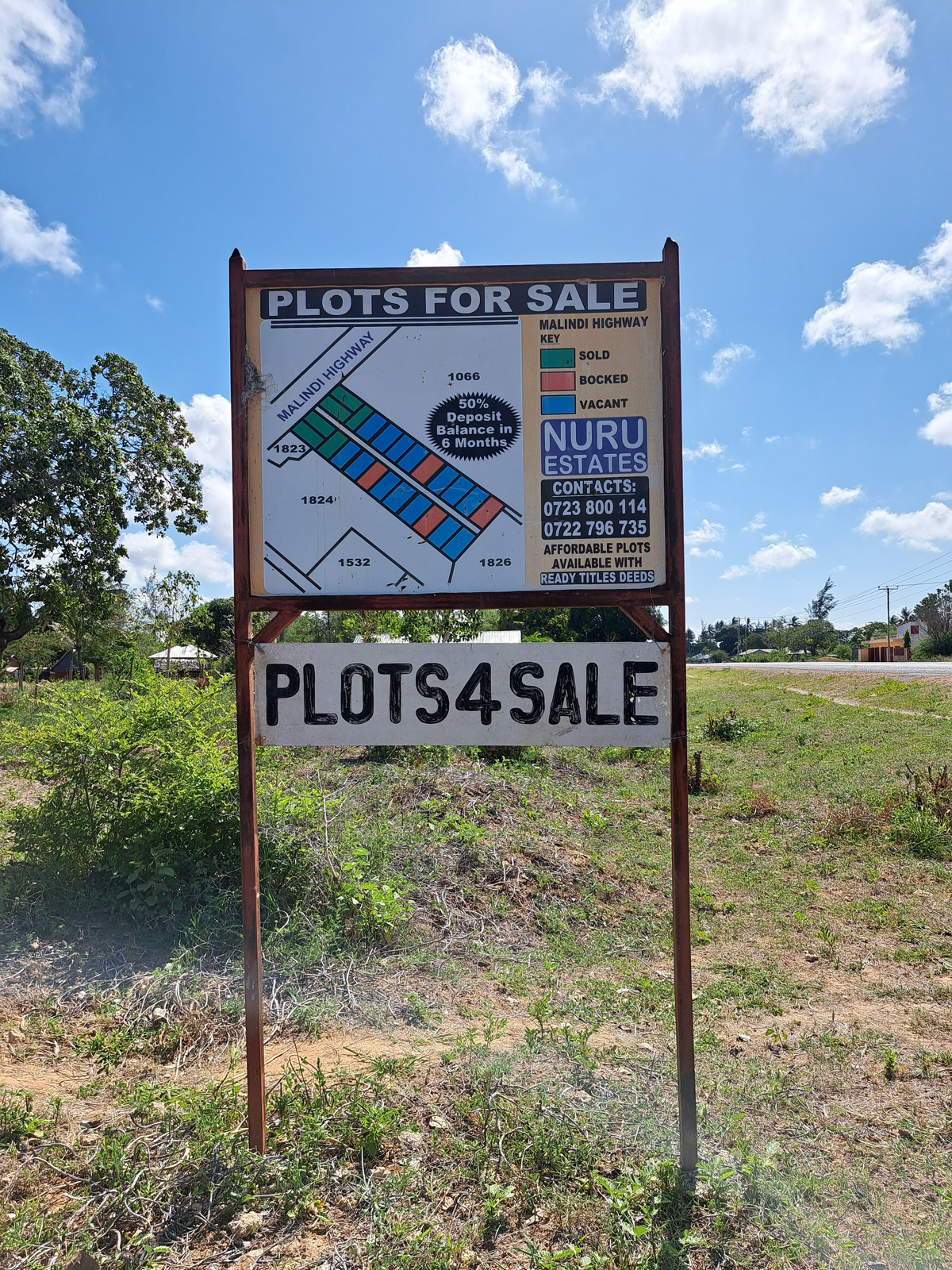
Figure 10
A signboard along the Mombasa-Malindi highway showing increased land speculation and fragmentation within Mida Creek area. Source: Authors, 2021.
In Mida Creek today (Figure 11), the Giriama ethos of living “with and within” the commons persist in settlements such as Kirepwe, Sudi, and Kisiwani, where households still depend on mangrove ecosystems for livelihoods. Yet these same ecosystems are now designated as part of the Watamu Marine Reserve, their use governed by conservation authorities whose frameworks often exclude local customary rights. The result is a reclassification of Giriama custodianship into “threat” status, legitimising further restrictions on access. Household surveys revealed the lived effects of this ontological dissonance. Artisanal fishers are confined to limited zones defined by the Kenya Wildlife Service; farmers contend with saline intrusion, declining freshwater availability, and shrinking arable land; tourism and real estate markets drive fragmentation of commons into subdivided plots, fracturing both ecological systems and kin-based governance.
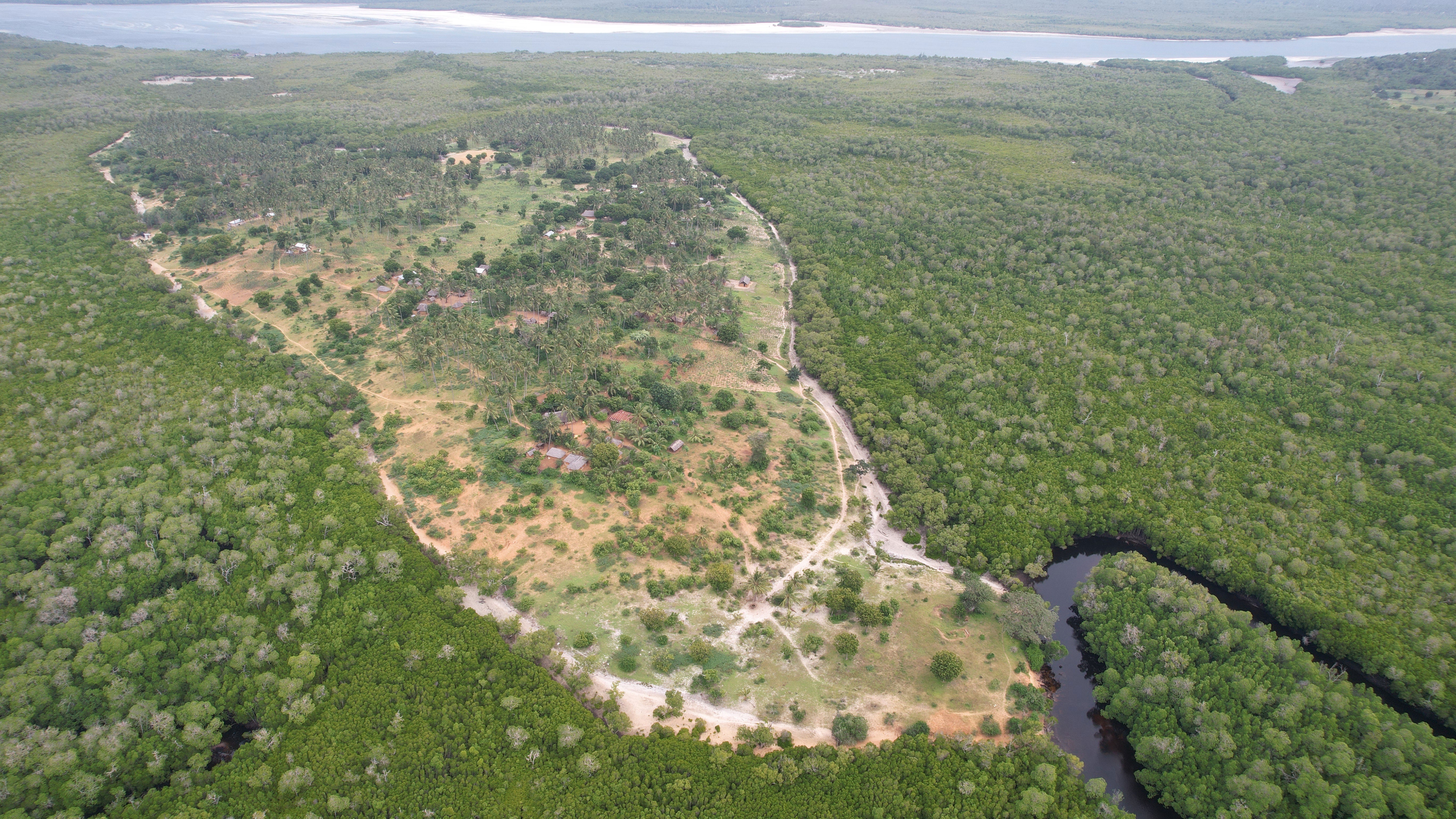
Figure 11
A drone imagery of the Kisiwani Island settlement within the Watamu Marine Reserve. It demonstrates that the Giriama community are still maintaining their traditional forest settlements logic and co-existing with the mangrove forest ecosystem. Source: Authors (August 2023).
This produces a paradoxical territorial frame (Figure 12). On one side is a community that once fed coastal stone towns through carefully managed forest commons, now rendered vulnerable, dispossessed, and dependent on precarious livelihoods. On the other is a booming tourism economy, luxury holiday villas with more water in swimming pools than available for the communities in the surrounding villages for their livelihoods. In this translation from Kaya commons to cadastral plots and conservation zones, the state-centric map does not simply represent space, it remakes it. It replaces an ontology of embedded reciprocity with one of exclusionary control, transforming custodians into trespassers. Counter-mapping thus becomes a tool for making these ontological conflicts visible, reclaiming Indigenous categories of space, and asserting that the Giriama’s relational geographies are not relics of the past but viable frameworks for equitable and sustainable commons governance in the present.
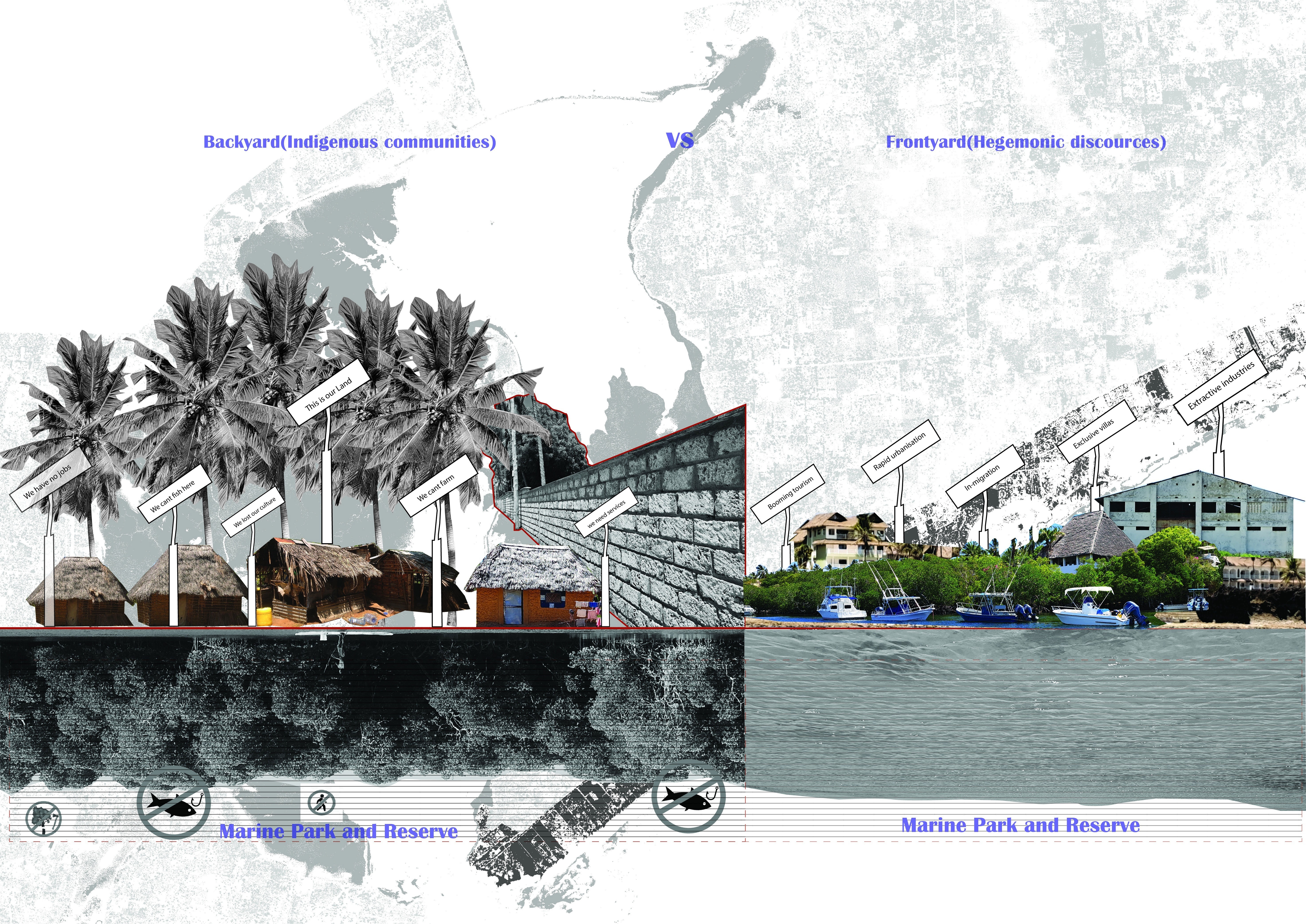
Figure 12
A Collage showing the spatial inequalities manifesting in Mida creek area. Framed in two paradoxical lenses labelled as ‘backyard’ and ‘front yard’. The former is the invisible reality that the Giriama community live in, while the latter is the mainstream identity of Mida Creek area as a booming tourist hub. Source: Authors, 2023.
Networks of Resistance: Counter-Mapping Community-Based Organizations in Mida Creek
Despite the structural pressures of dispossession, enclosure, and ontological displacement outlined in earlier sections, Mida Creek remains a site of vibrant grassroots mobilization. Much of this mobilization unfolds in what can be described as the commons-sphere of the mangrove forests and intertidal beaches that are spaces where community life and livelihood intersect most directly with state conservation regimes and the tourism economy. Here, Giriama residents, alongside other local actors, continuously renegotiate terms of access, use, and co-governance with powerful state agencies and dominant market players, most notably the hotel and tourism sector.
Rather than operating within the centralized, hierarchical governance models preferred by the state, these communities have sustained, and in some cases revitalized, forms of peer-to-peer governance rooted in their customary traditions of collective resource stewardship. Through self-organization, they have formed a dense network of Community-Based Organizations (CBOs) that actively participate in eco-tourism ventures, operate curio shops, guide visitors through mangrove and marine ecosystems, and run education and awareness programmes focused on local ecology and heritage. Many of these initiatives are spearheaded by women and youth, whose leadership has been critical in sustaining livelihoods while nurturing collective agency.
From the perspective of counter-mapping, documenting, and spatializing these CBO networks Figure 13 serves a dual purpose. First, it increases their visibility in ways that disrupt the spatial narratives propagated by hegemonic maps, which often depict such zones solely as protected areas, tourist destinations, or real estate assets that are erasing the active presence and agency of Indigenous and local communities. Second, it makes legible the relational webs of solidarity, exchange, and resistance that knit together disparate initiatives into a broader commons’ movement. In doing so, counter-mapping reframes these CBOs not as marginal, supplementary actors, but as active commoners that are dynamic agents continuously negotiating and, at times, resisting the exclusions imposed by state conservation logics and market appropriation. Their collaborative strategies range from developing hybrid governance arrangements with state authorities (e.g., joint conservation agreements, participatory tourism planning) to asserting community decision-making authority through umbrella associations that span multiple sectors. Examples include the Friends of the Arabuko Sokoke Forest, Watamu Marine Association, Community Forest Associations, and Beach Management Units, which bring together both state and non-state actors in shared governance platforms.
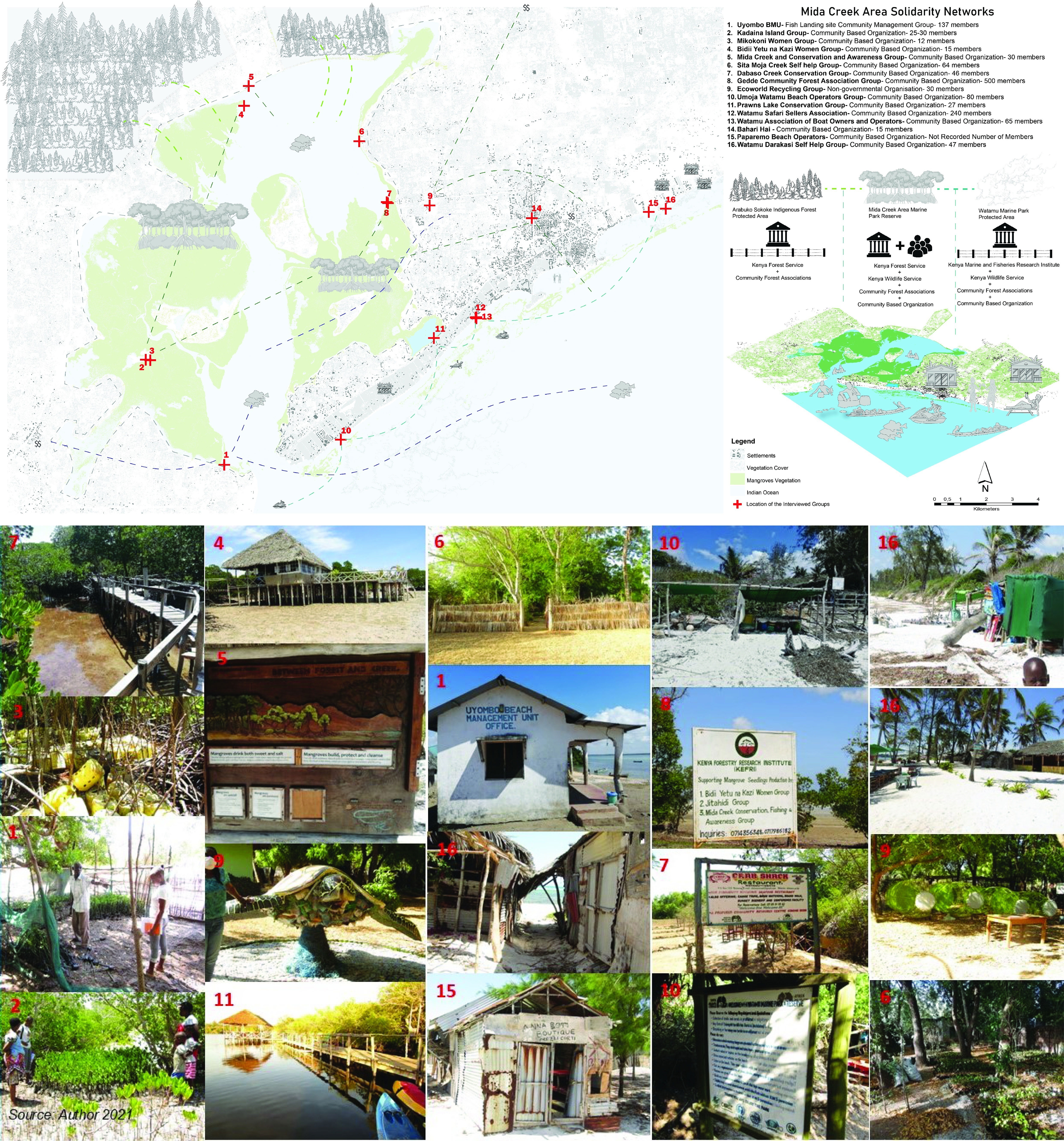
Figure 13
An annotated map illustration with corresponding images showing a network of Community Based Organizations’ that are actively engaging in re-negotiating for access to commons and commoning processes within Mida Creek area. Source: Authors (Dec 2021).
These solidarities are not static. They operate in a contested and politicized environment where access to resources and decision-making power must be constantly renegotiated, both within the community and in dialogue with external stakeholders. Yet, they represent a living counterpoint to the dominant spatial order: a collective praxis of commoning that persists in, and in some cases flourishes despite, conditions of enclosure. By mapping these networks, this research both records and participates in their epistemic reclamation. The resulting spatial visualizations do not merely document where CBOs are located; they unveil the socio-political terrain in which they operate as a territory defined not only by ecological boundaries, but also by relations of solidarity, conflict, adaptation, and shared care for the commons. As such, the CBOs of Mida Creek stand as a testament to the community’s capacity to reinvent governance in ways that are more equitable, ecologically grounded, and culturally resonant than the state-centric frameworks that have long dominated the region.
Conclusions
This paper has argued that the combined use of thick description mapping, and counter-mapping offers more than an alternative cartographic method. It constitutes a critical visual epistemology capable of unsettling dominant spatial orders and reclaiming suppressed territorial histories. By cantering the Indigenous Giriama community and their complex historical relationship with Mida Creek, the study has illuminated how mapping is never neutral: it is an active participant in processes of enclosure, displacement, and ontological reordering. The study has traced the layered genealogies of cartographic violence, from speculative imperial maps that rendered the coast as terra nullius, through colonial cadastral regimes that codified racialized property hierarchies, to post-colonial statecraft that has reproduced those same spatial logics. These hegemonic mappings have not only alienated the Giriama from their commons but have also reframed them, from rightful custodians of intricate ecological, cultural, and spiritual systems to “encroachers” within state-conserved landscapes and market-driven development zones.
Against this backdrop, counter-mapping in Mida Creek operates as an act of epistemic reclamation. By drawing on oral histories, customary land governance systems, and the lived spatial practices of the Giriama, it recovers ontologies of space that are relational, collective, and ecologically embedded. It also reveals the deep cultural significance of the Kaya as a historical common that were once the figure ground of settlement, governance, and ecological stewardship, showing how its principles persist, albeit transformed, in contemporary community-based conservation and livelihood practices.
These reframing challenges the ontological mismatch between state-centric, market-oriented spatial regimes and the Indigenous knowledge systems that have long sustained the Creek’s ecological and social balance. It also exposes the active role of mapping in mediating that conflict, both as a tool of exclusion and, when reclaimed, as an instrument of resistance and negotiation. Importantly, the counter-mapping of community-based organizations in Mida Creek makes visible a living network of commoners who are neither passive victims of enclosure nor nostalgic remnants of a pre-colonial order. Rather, they are active agents forging hybrid governance models, engaging in politicized negotiations over access, and sustaining solidarities that bridge ecological care with livelihood needs. These grassroots initiatives, often led by women and youth, are crucial nodes in an emergent commons-sphere, where the struggle for equitable access to land, water, and cultural heritage is ongoing and dynamic.
By unveiling these spatial practices, counter-mapping does more than produce alternative maps; it mobilizes alternative spatial imaginations. It provides a visual and narrative language through which marginalized communities can articulate claims, negotiate rights, and envision futures beyond the binaries of conservation versus development, or state control versus privatization. In doing so, it contributes to ongoing processes of (re)commoning as the gradual reassertion of collective stewardship, reciprocity, and shared governance over resources that have been historically alienated. The contribution of this paper is therefore twofold. First, it advances a methodological synthesis between counter-mapping and commons literature, demonstrating how mapping can be used not only to document but to actively co-produce political and ontological alternatives. Second, it offers a grounded case from Coastal Kenya that situates these methodological interventions within a long durée history of spatial contestation, making visible the continuities between colonial and post-colonial spatial orders and the grassroots strategies that resist them. Additionally, the Mida Creek case underscores that decolonizing mapping is not merely about correcting cartographic omissions. It is about transforming the spatial terms of political possibility. In post-colonial contexts where hegemonic maps still structure access, identity, and belonging, counter-mapping as an epistemic and political practice can help create openings for more just, inclusive, and ecologically grounded futures.
At the same time, the Mida Creek case suggests that the efficacy of counter-mapping in advancing (re)commoning processes hinges on conditions that operate across three interrelated levels. At the representational level, counter-mapping offers alternative graphical languages that disrupt the visual authority of hegemonic cartographies and make Indigenous spatialities legible to both internal and external audiences. At the epistemological level, the process of co-producing maps through oral histories, embodied practices, and customary governance re-centres relational ontologies of space, generating forms of knowledge that are collectively owned and politically mobilizable. Finally, at the socio-political level, the institutional uptake and recognition of counter-mapping as in community-based conservation initiatives and negotiations with state or NGO actors, are crucial for embedding them within governance frameworks that can sustain commons-oriented practices over time. Taken together, these dimensions clarify that counter-mapping is most transformative when it simultaneously unsettles dominant representations, reclaims suppressed epistemologies, and catalyses socio-political formations that anchor the commons within shifting regimes of power.