
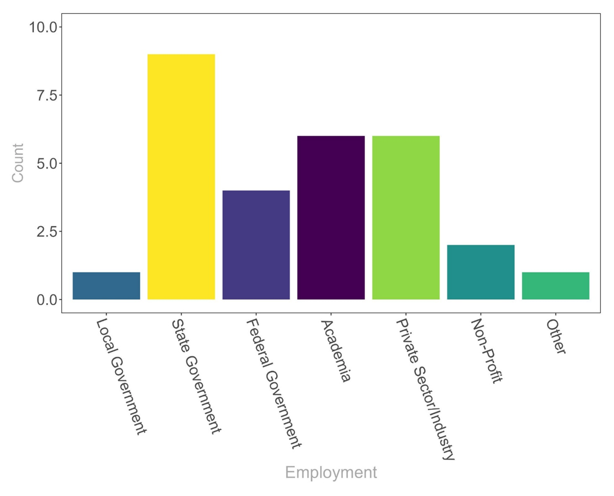
Figure 1
Respondent employment by institution type. Government employees make up the majority of survey respondents.
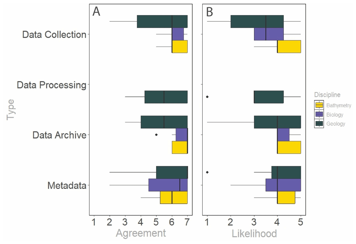
Figure 2
Column A) Level of agreement with the recommended standards for bathymetry, biology, and geology data collection, processing, archiving, and metadata. Column B) Likelihood of implementing the recommended standards for bathymetry, biology, and geology data collection, processing, archiving, and metadata. The results for chemical and physical oceanography data are not shown in this figure due to the low numbers of survey responses for these data types.
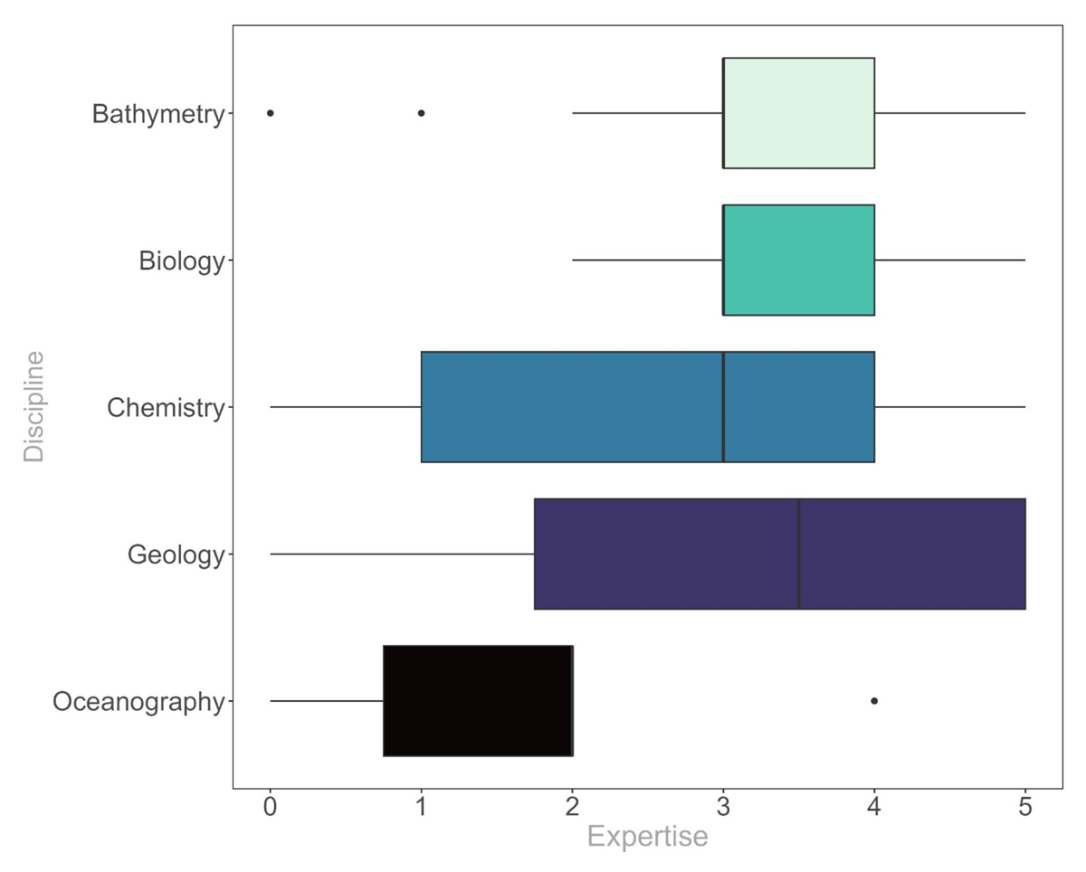
Figure 3
Expertise of respondents with different benthic data types. Respondents rated themselves most expert in biology and least in oceanography.
Table 1
Recommendations for archiving of data.
| DATA TYPE | PORTAL OR SYSTEM | LINK TO RESOURCE |
|---|---|---|
| Bathymetric and Backscatter Data | Global Multi-Resolution Topography (GMRT) | https://www.gmrt.org/about/contribute.php |
| Gulf Online Mapping Open Data Platform (GOMOD) | https://gmod-portal-gomalliance.hub.arcgis.com/ | |
| IHO Data Center for Digital Bathymetry (IHO DCBD) | https://www.ncei.noaa.gov/iho-data-centre-digital-bathymetry | |
| NOAA’s National Centers for Environmental Information (NCEI) | https://www.ncei.noaa.gov/archive | |
| Biological Data | Fish and Wildlife Conservation Commission’s Fish and Wildlife Research Institute (FWRI) | https://geodata.myfwc.com/ |
| Florida Department of Environmental Protection | https://geodata.dep.state.fl.us/ | |
| Florida Geospatial Open Data Portal | https://geodata.floridagio.gov/ | |
| Global Biodiversity Information Facility (GBIF) | https://www.gbif.org/ | |
| NOAA’s Environmental Research Division’s Data Access Program (ERDDAP) | https://www.ncei.noaa.gov/erddap/index.html | |
| NOAA’s National Centers for Environmental Information (NCEI) | https://www.ncei.noaa.gov/archive | |
| Ocean Biodiversity Information System (OBIS) | https://obis.org/ | |
| Chemical Data | Biological and Chemical Oceanographic Data Management Office system (BCO-DMO) | https://www.bco-dmo.org/ |
| Gulf of Mexico Research Initiative Information & Data Cooperative (GRIIDC) | https://www.griidc.org/ | |
| Geological Data | Florida Geological Survey (FGS)/Florida Department of Environmental Protection (FDEP) | https://floridadep.gov/fgs/data-maps |
| USGS National Geologic Map Database (MGMDB) | https://ngmdb.usgs.gov/ngmdb/ngmdb_home.html | |
| Physical Oceanography Data | Currents Measurement Interface for the Study of Tides (C-MIST) | https://cmist.noaa.gov/cmist/ssl/login.do |
| Gulf of America Coastal Ocean Observing (GCOOS) | https://gcoos.org/ | |
| National Buoy Data Center | https://www.ndbc.noaa.gov/ | |
| Southeast Coastal Ocean Observing System (SECOORA) | https://secoora.org/ |
Table 2
Average agreement of survey respondents to the proposed recommendations for bathymetric and backscatter data standards and average likelihood of adoption (n = 13).
| STANDARDS | AGREEMENT WITH RECOMMENDATIONS (7-POINT SCALE) | LIKELIHOOD OF ADOPTION (5-POINT SCALE) |
|---|---|---|
| Data Collection | 6.23 (±0.73) | 4.23 (±0.83) |
| Data Processing | 5.88 (±0.83) | 3.82 (±0.87) |
| Data Archiving | 6.60 (±0.52) | 4.40 (±0.52) |
| Metadata | 6.00 (±1.05) | 4.10 (±0.74) |
| Overall (Mean) | 6.20 (±0.81) | 4.14 (±0.77) |
Table 3
Average agreement of survey respondents to the proposed recommendations for biological data standards and average likelihood of adoption (n = 11).
| STANDARDS | AGREEMENT WITH RECOMMENDATIONS (7-POINT SCALE) | LIKELIHOOD OF ADOPTION (5-POINT SCALE) |
|---|---|---|
| Data Collection | 6.17 (±0.75) | 3.75 (±0.89) |
| Data Processing | 6.00 (±0.63) | 4.43 (±0.53) |
| Data Archiving | 6.50 (±0.84) | 4.29 (±0.49) |
| Metadata | 5.50 (±2.07) | 4.00 (±1.15) |
| Overall (Mean) | 6.04 (±1.20) | 4.10 (±0.82) |
Table 4
Average agreement of survey respondents to the proposed recommendations for chemistry data standards and average likelihood of adoption (n = 5).
| STANDARDS | AGREEMENT WITH RECOMMENDATIONS (7-POINT SCALE) | LIKELIHOOD OF ADOPTION (5-POINT SCALE) |
|---|---|---|
| Data Collection | 6.00 (±1.41) | 3.00 (±1.15) |
| Data Processing | 4.50 (±0.71) | 2.75 (±0.96) |
| Data Archiving | 5.50 (±0.58) | 3.50 (±1.00) |
| Metadata | 5.67 (±0.58) | 3.50 (±0.58) |
| Overall (Mean) | 5.45 (±0.82) | 3.19 (±0.91) |
Table 5
Average agreement of survey respondents to the proposed recommendations for geological data standards and average likelihood of adoption (n = 12).
| STANDARDS | AGREEMENT WITH RECOMMENDATIONS (7-POINT SCALE) | LIKELIHOOD OF ADOPTION (5-POINT SCALE) |
|---|---|---|
| Data Collection | 5.25 (±2.01) | 3.25 (±1.48) |
| Data Processing | 5.50 (±1.51) | 3.33 (±1.37) |
| Data Archiving | 5.42 (±1.44) | 3.75 (±1.36) |
| Metadata | 5.90 (±1.66) | 4.00 (±1.21) |
| Overall (Mean) | 5.50 (±1.64) | 3.58 (±1.35) |
Table 6
Average agreement of survey respondents to the proposed recommendations for physical oceanography data standards and average likelihood of adoption (n = 2).
| STANDARDS | AGREEMENT WITH RECOMMENDATIONS (7-POINT SCALE) | LIKELIHOOD OF ADOPTION (5-POINT SCALE) |
|---|---|---|
| Data Collection | 6.00 | 4.00 |
| Data Processing | 4.00 | 3.00 |
| Data Archiving | 7.00 | 5.00 |
| Metadata | 7.00 | 3.50 |
| Overall (Mean) | 6.00 | 3.88 |
Table 7
Overall average agreement of survey respondents to the proposed recommendations for benthic data standards (regardless of data type) and average likelihood of adoption (n = 53).
| STANDARDS | AGREEMENT WITH RECOMMENDATIONS (7-POINT SCALE) | LIKELIHOOD OF ADOPTION (5-POINT SCALE) |
|---|---|---|
| Data Collection | 5.86 (±1.38) | 3.70 (±1.16) |
| Data Processing | 5.54 (±1.43) | 3.59 (±1.19) |
| Data Archiving | 6.06 (±1.13) | 4.10 (±0.98) |
| Metadata | 5.90 (±1.42) | 3.94 (±1.03) |
| Overall (Mean) | 5.85 (±1.33) | 3.82 (±1.10) |