
1. Introduction
Efforts and programs to map and monitor the seafloor, its patterns and processes, and mechanisms to make the resulting data publicly available are increasingly being put in place worldwide (Bosso et al., 2025). Examples include AusSeabed in Australia (Townsend et al., 2023), MAREANO in Norway (Buhl-Mortensen et al., 2015a), and the pan-European EMODnet (Míguez et al., 2019). In the United States, the National Strategy for Ocean Mapping, Exploring, and Characterizing (NOMEC), released in 2020, aims to map the waters deeper than 40 meters within the country’s exclusive economic zone by 2030 and coastal areas by 2040 (OSTS, 2020). The mapping data from this effort include bathymetry, seabed and sediment types, sub-bottom geology, and the physical, chemical, and biological characteristics of the seabed and water column. Both the NOMEC strategy and the other international programs listed above (e.g., EMODnet) emphasize that, given the human, technical, and financial resources involved, benthic data collected must be made freely accessible and usable to the public for various purposes.
Spatially-integrated marine benthic data provide the foundation for effective spatial decision-support tools that address critical issues in marine and coastal systems (Guisan et al., 2013; Levin et al., 2014). Developing such tools enables the study of environmental patterns and processes in contexts such as marine conservation, resources management, and ecological research (e.g., Cogan et al., 2009; Buhl-Mortensen et al., 2015b). However, the diversity of benthic data types and forms often presents challenges for proper data integration. For example, the production of benthic habitat maps requires the integration into a common geographic framework of multiple types of data (e.g., bathymetry, chemical properties, species occurrences), of different forms (e.g., points, lines, polygons, rasters), and collected at different spatial and temporal scales (Lecours, 2019). Without common standards, these data cannot be easily integrated and reused, thus missing opportunities to ‘collect once and use many times’.
Addressing this need involves some planning, in particular as it pertains to data and metadata standards. Benthic data collection efforts are most often local, fueled by the need to answer one or a few specific questions in a particular context. As such, data collection may not be performed with the long-term goal of integrating the newly acquired data with other existing datasets or data that might be collected in the future. In addition, it has been noted that researchers and practitioners do not always carefully select data for benthic characterization; instead, data are chosen primarily based on availability or ease of collection rather than on their ecological meaning and fitness-for-use (Peterson et al., 2011; Tulloch et al., 2016; Lecours et al., 2017). Granting agencies and data collection teams do not always specify the standards or guidelines used for data collection, production, and management, with impacts for future data use. In habitat mapping, for example, discrepancies between projects and data may lead to vastly different habitat maps and impact the decisions that are informed by such maps (Lecours, 2017). Strong, consistent, transparent, repeatable, and science-based protocols for data collection, archiving, and metadata are essential for effectively supporting decision-makers in contexts such as developing conservation and management plans. Ensuring that data are ‘freely accessible, interchangeable, operational, of high quality, and up-to-date’ develops digital resilience (Wright, 2016) and aligns with FAIR (Findable, Accessible, Interoperable, Reusable) principles (Wilkinson et al., 2016).
The State of Florida has strong ties to the marine environment. Its coastal waters generate billions in revenue per year, support some of the nation’s highest recreational use, host one of the highest concentrations of coastal communities in the United States, and has multiple nationally-ranked commercial seaports (USGS, 2018). The Florida Coastal Mapping Program has recognized the critical need for seafloor data in Florida to better understand mineral resource distribution, examine sea-level rise indicators, and inform decision-making in contexts such as coastal zone management, navigation, and coastal resilience planning (FCMaP, 2019). A 2007 workshop with regional, state, and federal stakeholders also concluded that whereas mapping coastal resources was a top priority, the lack of coordination was preventing broad-scale mapping from happening (Robbins et al., 2008). Since then, the Florida legislature has appropriated $100 million for coastal bathymetric mapping in 2021–2022. As these data become available, the need for standardized mapping frameworks becomes more significant.
However, despite past and ongoing efforts from regional, state, and federal governments to study Florida’s marine ecosystems and resources and repeated calls for a standardized approach to mapping them, there is currently no general framework to guide conservation, management, and research of seafloor environments and resources in Florida. As such, and in the context of a recent increase in seafloor mapping efforts in Florida by government, academic, and non-profit sectors (FCMaP, 2019; Radabaugh et al., 2019), the collected data remain unstandardized and have yet to be combined into a unified statewide database.
The goal of this paper is to develop informed, expert-based recommendations grounded in the literature on benthic data and metadata standards to facilitate the integration of multi-source benthic datasets in Florida. The recommendations were shared with the Florida-based stakeholder community to quantify the overall level of agreement, the likelihood of their widespread adoption, and the types of tools needed to increase that likelihood.
2. Methods
In 2021, the idea of defining a standardized framework for benthic data and metadata integration in Florida was presented to stakeholders in the State of Florida through events such as the Florida Coastal Mapping Program annual summit and the Florida RESTORE Act Centers of Excellence Program meetings. Following these events, discipline-specific experts were invited to join a working group to work on recommendations for benthic data and metadata standards. The choice of experts was based on geographic and expertise diversity in the State of Florida. While most experts work in academia, we ensured that state and federal agencies were represented in the working group to encompass multiple perspectives, needs, and existing approaches. Partnership network leaders (e.g., from the Gulf of America Alliance) were also involved. The group of experts examined each of the five data types listed in the NOMEC strategy in the context of Florida benthic environments. The five data types are 1) bathymetric and backscatter data; 2) biological data (e.g., species occurrences, other biological observations); 3) chemistry data (e.g., oxygen concentration in water, sedimentary calcium carbonate concentration); 4) geological and geomorphological data (e.g., sediment sample or core, morphological feature documentation and characterization); and 5) physical oceanography data (e.g., pressure, temperature, bottom currents).
A half-day workshop was organized on November 30th, 2022. Participants averaged 20.5 years of experience in their discipline (total = 205 years, SD = 10.5 years) at the time of the meeting. The meeting objectives were to build community among the team of experts attending, to share information about the project, and to discuss expectations and how to build a successful project. An exercise was held in which experts identified current gaps, existing standards, and other important elements associated with marine benthic data usage in Florida. The specific data-sharing and standardization needs for Florida were discussed and situated within national and international efforts. More details on how the workshop was conducted and some outcomes of the discussion can be found in Qiao et al. (2024).
Following this meeting, each expert assembled a discipline-specific subgroup based on the five data types listed above to conduct a meta-analysis of commonly-used standards for each data type at the national and international levels. The meta-analysis was published as an open-access report (Lecours and Braswell, 2025); its chapters list the members of each subgroup. Informed by this meta-analysis, each discipline-specific subgroup made recommendations on data and metadata standards to be implemented in Florida for the collection, processing, and archiving and sharing of benthic data and for metadata. These recommendations are presented in Section 3.
Finally, an online survey was distributed to present the recommendations to the community of stakeholders in the State of Florida and to evaluate their level of agreement with them and their likelihood of adopting these standards. Before distribution, the survey underwent a review by the University of Florida Institutional Review Board (IRB) and was ruled exempt from continued IRB oversight (Protocol #ET00022015). The survey was distributed in early February 2024 through targeted individual and group solicitations (e.g., relevant departments at various Florida universities, colleges, and state agencies) and various email lists and newsletters of interest that cover the targeted audience (e.g., Florida Institute of Oceanography (FIO), Florida Coastal Mapping Program (FCMaP), Coastal Habitat Integrated Mapping and Monitoring Program, Oyster Integrated Mapping and Monitoring Program). The invitation included a request to share widely through each recipient’s network. This recruitment strategy was adopted to cast the widest net possible; however, it makes it difficult to estimate the overall number of people reached through it. For example, in June 2026, the FIO mailing list had 776 recipients, and the FCMaP mailing list had 218 recipients. In addition, the likelihood of some overlap among the different lists used is high. We thus estimate that we reached more than 1,000 different people through the various means of distribution. A few reminders were sent, and the survey was closed in late June 2024. The specific survey questions are included in Supplementary File 1. The survey was built in the Qualtrics platform and first included questions about respondent demographics (e.g., sector of activity, areas of expertise, primary role in their organization). Then, respondents had to select which of the five types of benthic data considered they interact with (i.e., collect, process, analyze, consult/visualize, distribute/share). They could also input other data types. Only the recommendations related to the data type(s) they selected were then presented to them. For example, a benthic ecologist who selects biological and bathymetric data would only be shown the recommended standards for these two data types and would only have to answer the questions associated with them. For each data type selected, they first had to rate their expertise from 0 (no expertise at all) to 5 (very high expertise). Then, the recommended standard(s) for data collection were presented, with hyperlinks to resources if pertinent. Following the presentation of the standards, respondents needed to rate their agreement with the proposed standards from 1 (strongly disagree) to 7 (strongly agree). An additional box was made available for respondents to explain why they do not agree with the proposed standards, if that was the case. Then, they had to answer the question ‘What is the likelihood that you will refer to and implement these standards in your own projects?’ on a slider scale ranging from 1 (extremely unlikely) to 5 (very likely). Again, a text box was available to explain, if that was the case, why it is unlikely for them to refer to and implement the proposed standards in their own projects. Two more questions were asked: 1) ‘What recommendations, if any, do you have to improve or revise the suggested standards?’ and 2) ‘Are there specific tools, existing or not, that would help you implement these standards or that would be necessary for you to meet these standards?’ The same series of questions would then be asked for data processing standards, metadata standards, and data archiving and publication standards. If they selected more than one data type, the process would be repeated for each. If an additional data type was added in the first step (besides the five already considered), input was requested on standards to implement for these data types. At the end of the survey, an opportunity was provided to add any additional comments.
3. Results
This section first introduces the profile of the respondents who answered the survey. Then, results are organized by data type; for each data type, the standards recommended by the experts for data collection, data processing, data archiving and publication, and for metadata are summarized. More details on how these recommendations were made can be found in Lecours and Braswell (2025). Following the recommendations, the survey responses associated with the data type being discussed are presented.
3.1 Survey respondents
We had 44 respondents who opened the survey, 34 who responded to at least one technical question (beyond demographics) on the survey, and 18 who completed at least 80% of it. The majority of the respondents (n = 17) were employed by government agencies (federal, local, and state; Figure 1). Most respondents worked with data in Florida as well as other states (8.8% in Florida and Atlantic states; 8.8% in Florida and Gulf states; 61.7% in Florida and other states; 14.7% in Florida only; 5.9% in other states). Respondents indicated that they mainly worked in the following counties in Florida: Alachua, Brevard, Broward, Duval, Hillsborough, Lee, Palm Beach, Martin, Pinellas, and St. Johns. Many people indicated they were based in multiple counties (7 people), with Pinellas having the second highest number of respondents (5 people). Most respondents identified as researchers (35.7%) or department/program managers (32.1%), with other respondents identifying as data managers (3.5%), data technicians (10.7%), field activity coordinators (3.5%), field technicians (3.5%), lab supervisors (3.5%), scientists (3.5%), and other (3.5%).
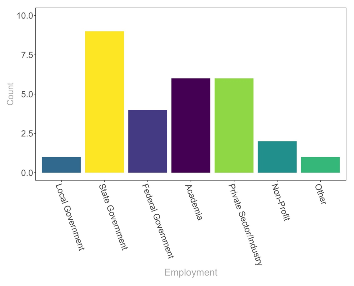
Figure 1
Respondent employment by institution type. Government employees make up the majority of survey respondents.
The specific results for the agreement with standards and likelihood of adoption are summarized in Figure 2 but are presented in detail in each subsection below. However, we note that there were enough respondents to fully assess these two elements only for bathymetry (n = 13), biology (n = 11), and geology (n = 12). In contrast, there were not enough respondents to fully analyze the chemistry (5 respondents to some questions and 3 respondents to the agreement and likelihood questions) and oceanography (12 respondents to some questions and 2 respondents to the agreement and likelihood questions) standards. Respondents rated their expertise on a five-point scale, with respondents ranking themselves the highest in biology (mean = 3.45) and lowest in oceanography (mean = 1.67; Figure 3). The mean expertise level for geology was 3.08, followed by bathymetry and backscatter at 2.94 and chemistry (2.60).
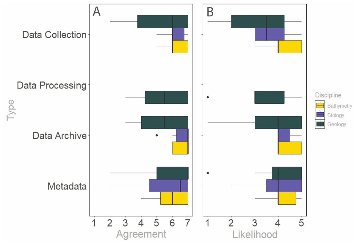
Figure 2
Column A) Level of agreement with the recommended standards for bathymetry, biology, and geology data collection, processing, archiving, and metadata. Column B) Likelihood of implementing the recommended standards for bathymetry, biology, and geology data collection, processing, archiving, and metadata. The results for chemical and physical oceanography data are not shown in this figure due to the low numbers of survey responses for these data types.
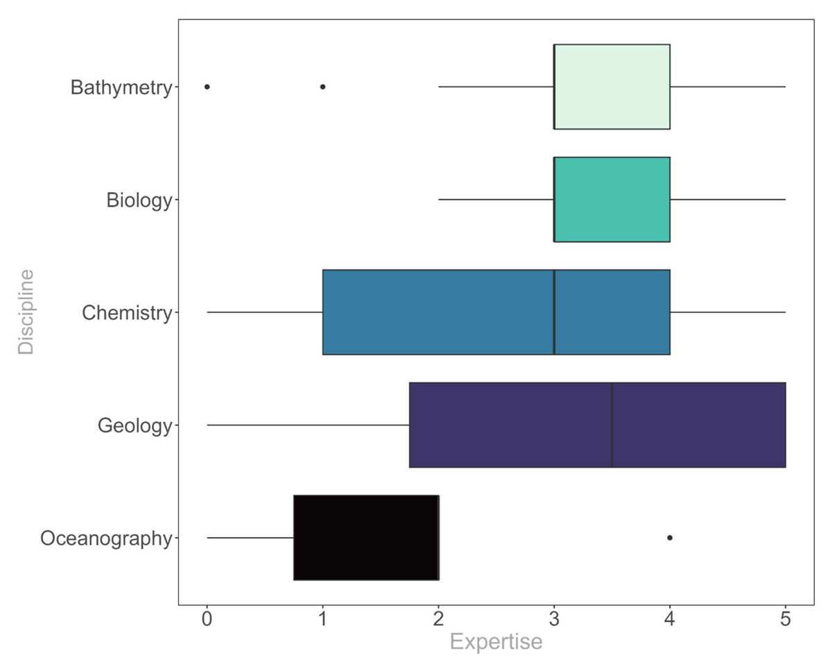
Figure 3
Expertise of respondents with different benthic data types. Respondents rated themselves most expert in biology and least in oceanography.
3.2 Bathymetric and backscatter data standards
This category of data includes bathymetry, backscatter, and reflectance data. Bathymetry is underwater topography, represented as an array of depth values. Bathymetry can be collected from single-beam and multibeam echosounders, bathymetric lidar systems, and other optical sensors mounted on platforms such as satellites or drones (e.g., Murawski et al., 2025). Acoustic backscatter can be collected mainly from multibeam echosounders. Reflectance can be collected from optical sensors.
3.2.1 Standards for data collection
For acoustic bathymetry, experts recommended aligning with those of the Interagency Working Group on Ocean and Coastal Mapping (IWG-OCM), a working group of the National Science and Technology Council Subcommittee on Ocean Science and Technology. These recommendations are outlined in the Standard Ocean Mapping Protocol (SOMP; IWG-OCM, 2024). In short, the SOMP recommends using the International Hydrographic Organization’s (IHO) minimum bathymetry standards and feature detection requirements defined in Table 1 of IHO’s Publication S-44 Edition 6.1.0 (IHO, 2020), in tandem with the specification matrix in Chapter 7.6 of Publication S-44 for criteria ranges to enhance the minimum standards. Additional recommendations from the IWG-OCM include mapping to complete coverage, using set line spacing, data collection during transit, performing crosslines for validation, correcting for tides, and providing uncertainty.
Table 1
Recommendations for archiving of data.
| DATA TYPE | PORTAL OR SYSTEM | LINK TO RESOURCE |
|---|---|---|
| Bathymetric and Backscatter Data | Global Multi-Resolution Topography (GMRT) | https://www.gmrt.org/about/contribute.php |
| Gulf Online Mapping Open Data Platform (GOMOD) | https://gmod-portal-gomalliance.hub.arcgis.com/ | |
| IHO Data Center for Digital Bathymetry (IHO DCBD) | https://www.ncei.noaa.gov/iho-data-centre-digital-bathymetry | |
| NOAA’s National Centers for Environmental Information (NCEI) | https://www.ncei.noaa.gov/archive | |
| Biological Data | Fish and Wildlife Conservation Commission’s Fish and Wildlife Research Institute (FWRI) | https://geodata.myfwc.com/ |
| Florida Department of Environmental Protection | https://geodata.dep.state.fl.us/ | |
| Florida Geospatial Open Data Portal | https://geodata.floridagio.gov/ | |
| Global Biodiversity Information Facility (GBIF) | https://www.gbif.org/ | |
| NOAA’s Environmental Research Division’s Data Access Program (ERDDAP) | https://www.ncei.noaa.gov/erddap/index.html | |
| NOAA’s National Centers for Environmental Information (NCEI) | https://www.ncei.noaa.gov/archive | |
| Ocean Biodiversity Information System (OBIS) | https://obis.org/ | |
| Chemical Data | Biological and Chemical Oceanographic Data Management Office system (BCO-DMO) | https://www.bco-dmo.org/ |
| Gulf of Mexico Research Initiative Information & Data Cooperative (GRIIDC) | https://www.griidc.org/ | |
| Geological Data | Florida Geological Survey (FGS)/Florida Department of Environmental Protection (FDEP) | https://floridadep.gov/fgs/data-maps |
| USGS National Geologic Map Database (MGMDB) | https://ngmdb.usgs.gov/ngmdb/ngmdb_home.html | |
| Physical Oceanography Data | Currents Measurement Interface for the Study of Tides (C-MIST) | https://cmist.noaa.gov/cmist/ssl/login.do |
| Gulf of America Coastal Ocean Observing (GCOOS) | https://gcoos.org/ | |
| National Buoy Data Center | https://www.ndbc.noaa.gov/ | |
| Southeast Coastal Ocean Observing System (SECOORA) | https://secoora.org/ |
For acoustic backscatter collected from multibeam echosounders, our group of experts recommended following the GeoHab Backscatter Working Group’s (BSWG) guidelines and recommendations for backscatter measurements by seafloor-mapping sonars, outlined in Rice et al. (2015) and also discussed in Lamarche and Lurton (2018).
For lidar bathymetry, the standards established by the United States Army Corps of Engineers (USACE) Engineering, Research and Development Center (ERDC) and their Joint Airborne Lidar Bathymetry Technical Center of Expertise (JALBTCX) are recommended. These Topo-Bathy Lidar Specifications are being developed by JALBTCX with the Naval Oceanographic Office (NAVOCEANO), the National Oceanic and Atmospheric Administration (NOAA), and the United States Geological Survey (USGS). The SOMP standards for lidar bathymetry are directly derived from these specifications.
3.2.2 Standards for data processing
For acoustic bathymetry, our expert group recommended using the CUBE (Combined Uncertainty and Bathymetry Estimator) algorithm (Calder and Wells, 2007) but recognized that developments in processing algorithms are common and that this recommendation is likely to change in the future.
For acoustic backscatter, the group recommended following the GeoHab Backscatter Working Group’s guidelines and recommendations for backscatter measurements by seafloor-mapping sonars, outlined in Schimel et al. (2015) and expanded upon in Schimel et al. (2018). However, they acknowledged that there are currently no standardized data processing approaches (Malik et al., 2019) and that these recommendations are subject to change.
For lidar data, the standards from the American Society for Photogrammetry and Remote Sensing (ASPRS) (ASPRS, 2024) associated with the open format LAS are recommended.
For satellite-derived bathymetry, they recommended following standards outlined in the IHO Publication B-13 (IHO, 2024).
3.2.3 Standards for data archiving and publication
Experts recommended that all data, including the raw (unprocessed) bathymetric and backscatter data, be shared with NOAA’s National Centers for Environmental Information (NCEI). For processed bathymetry and backscatter data, they recommended following the IHO’s S-102 Standard for Bathymetry, which includes the use of the “.bag” (bathymetric attributed grid) format for sharing bathymetry, a format that carries both bathymetry and uncertainty information. They also recommended that processed data be shared, regardless of data collection methods, with their uncertainty layer and at the highest achievable spatial resolution, with the Global Multi-Resolution Topography (GMRT) data synthesis, the Gulf Online Mapping Open Data Platform (GOMOD), and the IHO Data Center for Digital Bathymetry (IHO DCDB) (Table 1). They also noted that if the Florida Seafloor Mapping Initiative (FSMI) of the Florida Geographic Information Office starts offering data archiving in the future, it would be relevant to submit Florida data there.
3.2.4 Metadata standards
For bathymetric data, the subgroup of experts for bathymetric and backscatter data recommended that metadata standards align at minimum with Chapter 6 of the IHO’s Publication S-44 Edition 6.1.0 (IHO, 2020), but also recommended, when possible, adding all available information such as is outlined in Chapter 3 of IHO’s Publication B-12 for crowdsourced bathymetry (IHO, 2018a), Chapter 4 of Publication B-13 for satellite-derived bathymetry (IHO, 2024), and the S-100 Discovery Metadata Standard (IHO, 2018b), which were adapted by NOAA (see https://nauticalcharts.noaa.gov/learn/docs/precision-navigation/s-100_discovery_metadata_readme.pdf).
For backscatter data, standards have not yet been adopted internationally, but experts recommended following the suggestions made in Table 7.2 of the GeoHab Backscatter Working Group’s guidelines and recommendations (Lurton and Lamarche, 2015) and expanded upon in Schimel et al. (2018).
For lidar data, they recommended adopting the ASPRS LAS specifications and recommendations from Lück-Vogel et al. (2018). Metadata should be stored in an XML format.
3.2.5 Agreement with bathymetric and backscatter data and metadata standards
Overall, there was good agreement with the data standards proposed for this discipline (Table 2; Figure 2). In addition, respondents indicated that they were likely to adopt the standards (Table 2; Figure 2). Respondents provided no substantial comments or suggestions for the bathymetry and backscatter data standards, nor any additional comments.
Table 2
Average agreement of survey respondents to the proposed recommendations for bathymetric and backscatter data standards and average likelihood of adoption (n = 13).
| STANDARDS | AGREEMENT WITH RECOMMENDATIONS (7-POINT SCALE) | LIKELIHOOD OF ADOPTION (5-POINT SCALE) |
|---|---|---|
| Data Collection | 6.23 (±0.73) | 4.23 (±0.83) |
| Data Processing | 5.88 (±0.83) | 3.82 (±0.87) |
| Data Archiving | 6.60 (±0.52) | 4.40 (±0.52) |
| Metadata | 6.00 (±1.05) | 4.10 (±0.74) |
| Overall (Mean) | 6.20 (±0.81) | 4.14 (±0.77) |
3.3 Biological data standards
Biological monitoring is a fundamental requirement for formulating biodiversity and ecosystem baselines and to document status, change, and trends in any area. Collecting and formatting data to enable interoperability and proper dissemination of biological data for synthesis and assessments is often challenging. Concrete strategies and guidelines are now available for monitoring broad categories of biology and ecosystem Essential Ocean Variables (EOV) defined by the Global Ocean Observing System (GOOS) (Miloslavich et al., 2018). Essential Ocean Variables (EOVs) are a fundamental concept that guides the collection of individual observations needed to build time series at specific locations and maps, which represent the Essential Biodiversity Variables promoted by the Group on Earth Observations Biodiversity Observation Network and its marine theme (Marine Biodiversity Observation Network/MBON of GEO BON) (Muller-Karger et al., 2018). Specific guidance for deep water EOVs is evolving, as described in Levin et al. (2019), Danovaro et al. (2020), and Ingels et al. (2021).
3.3.1 Standards for data collection
The Ocean Best Practices System (OBPS; https://www.oceanbestpractices.org/) provides access to guidelines and training materials developed by the Ocean Biodiversity Information System (OBIS; https://obis.org/), the Marine Biodiversity Observation Network (MBON; https://marinebon.org/), and many other groups involved in the ocean observing and applications value chain. While there are many different data collection protocols, our experts recommended that the community use data collection protocols from OBPS if available. Furthermore, they recommended contributing to OBPS documentation on new practices for the benefit of a larger community. Practices archived with OBPS should be peer-reviewed and may be previously published, and practitioners may request that OBPS assist in having the practices ‘endorsed’ by a recognized group of experts, such as an expert panel of the Global Ocean Observing System or another group.
3.3.2. Standards for data processing
Experts recommended following the primer that the Earth Science Information Partnership (ESIP) Biological Data Standards Cluster (https://wiki.esipfed.org/Biological_Data_Standards_Cluster) has developed to help navigate different biological data standards and help format, curate, and enhance the interoperability of biological information. When biological data are being used to classify or characterize habitats, they noted that classification schemes are objective-dependent and that standards are difficult to apply. However, when appropriate, they recommended adopting the Coastal and Marine Ecological Classification Standard (CMECS) (FGDC, 2012), commonly applied nationally, or the International Union for Conservation of Nature (IUCN) Global Ecosystem Typology (https://global-ecosystems.org/) that is commonly applied internationally.
3.3.3 Standards for data archiving and publication
The team of experts on this type of data recommended depositing the data and metadata via repositories that are well-known and that explicitly seek to be interoperable and sustainable for the long term. At the global level, data should be published to the Ocean Biodiversity Information System (OBIS) and the Global Biodiversity Information Facility (GBIF) (Table 1) using the Integrated Publishing Toolkit (IPT; https://www.gbif.org/ipt). At the national level, they recommended NOAA’s Environmental Research Division’s Data Access Program (ERDDAP) and National Centers for Environmental Information (NCEI) (Table 1). In Florida, the Fish and Wildlife Conservation Commission’s Fish and Wildlife Research Institute (FWRI), the Florida Department of Environmental Protection (including the Florida Geological Survey), and the Florida Geospatial Open Data Portal of the Florida Geographic Information Office have relevant databases that should be consulted and used as repositories (Table 1).
3.3.4 Metadata standards
Experts in biology recommended following the primer that the Earth Science Information Partnership (ESIP; https://wiki.esipfed.org/Biological_Data_Standards_Cluster) has developed to help navigate different biological metadata standards and the Darwin Core (https://dwc.tdwg.org/) to format and publish biological metadata.
3.3.5 Agreement with biological data and metadata standards
For this discipline, there was good but slightly lower agreement and likelihood of adoption of the standards than for bathymetric data (Table 3; Figure 2). In addition, respondents indicated that they were likely to adopt the standards (Table 3; Figure 2).
Table 3
Average agreement of survey respondents to the proposed recommendations for biological data standards and average likelihood of adoption (n = 11).
| STANDARDS | AGREEMENT WITH RECOMMENDATIONS (7-POINT SCALE) | LIKELIHOOD OF ADOPTION (5-POINT SCALE) |
|---|---|---|
| Data Collection | 6.17 (±0.75) | 3.75 (±0.89) |
| Data Processing | 6.00 (±0.63) | 4.43 (±0.53) |
| Data Archiving | 6.50 (±0.84) | 4.29 (±0.49) |
| Metadata | 5.50 (±2.07) | 4.00 (±1.15) |
| Overall (Mean) | 6.04 (±1.20) | 4.10 (±0.82) |
We received additional comments from the respondents in our open-ended questions. One respondent found the metadata standards “difficult to interpret for implementation.” Another respondent recommended communication and education around standards. They have found that there is not enough education on standards, and they did not know of these standards before they took the survey.
3.4 Chemical data standards
Water chemistry at the benthic boundary layer of the world’s oceans represents exchange, and sometimes equilibrium, between the underlying sediments and the water column above. Ocean chemists and chemical oceanographers will measure data from the full water column, generally stopping profiling data loggers approximately 1 m above the surface to avoid contaminating the sensors with porewater and bottom sediment. Marine geologists attempt to capture gradients across the sediment-water interface with box cores and multicores but disregard the sediment-water interface when obtaining deeper cores obtained by gravity cores or piston cores. Between these two sampling regimes, water column and surficial-sediment, biogeochemists have developed landers that measure chemical exchange at the seawater-sediment interface.
3.4.1 Standards for data collection
Water column data is almost universally collected from Seabird CTDs (Conductivity, Temperature, and Depth sensors). Despite the constraints of the acronym, multiple other sensors, including O2, transmissivity, fluorescence, and others that may be important to benthic chemistry, can make up the payload of these versatile instruments. Biogeochemists have also developed landers that can make measurements of chemical exchange at the seawater-sediment interface continuously for an amount of time determined by battery life with certain measurement payloads. The consulted experts recommended aligning data collection with the latest standards for data collection of discrete observations made aboard shipboard platforms, outlined in Jiang et al. (2022).
3.4.2 Standards for data processing
Generally, Seabird CTD data files need to be processed with Seabird software to produce files that are readable in most data analysis and visualization programs, such as Excel, Matlab, and Python, among others. Once processed, any of these platforms can be used to obtain metadata such as ship latitude and longitude, timestamps, and depths. Data from these deployments generally conform to the standards outlined in Jiang et al. (2022), which our team of experts recommended using. These standards include information about data header conventions as well as conventions for quality control flagging of data and missing values and encourage the use of the Exchange data file format.
3.4.3 Standards for data archiving and publication
Experts recommended archiving Florida benthic chemistry data in the Gulf of Mexico Research Initiative Information & Data Cooperative (GRIIDC) repository and the Biological and Chemical Oceanographic Data Management Office system (BCO-DMO) (Table 1).
3.4.4 Metadata standards
The experts indicated that to relate benthic chemistry to underlying geologic sampling, it is important to merge data types, such as hand-written deck logs for geologic data, with the depth-binned benthic chemistry data from the CTD and from discrete bottle samples taken near the boundary. Thus, it is important to populate deck logs for geological sampling with data that link geological and chemical data, like time of deployment (to calculate elapsed time between water column and sediment deployments), weather conditions (e.g., squalls delayed deployment after CTD casts), and other metadata that relate the geological samples to the water column measurements. Position, time, and local conditions are important metadata for benthic chemistry samples, but so are qualitative descriptions of the bottom. Once benthic samples are retrieved, it is important to link time-sensitive samples such as porewaters to water column data streams through sample labeling that makes indexing to deck logs and CTD casts possible. The standards outlined in Jiang et al. (2022) contain recommendations for sequential numbering of over-the-side deployments at each site or sequential numbering of unique sites for every over-the-side deployment. Our experts recommended adopting these simple recommendations, which, when adapted for geological as well as chemical data collection, can facilitate biogeochemical studies using observations of both types. Lander data should be referenced by the same over-the-side sequence as other deployments; however, the timestamp of the data recorded while deployed will be the most important metadata for the continuous data stream generated.
3.4.5 Agreement with chemistry data and metadata standards
Only three responses were received for the evaluation of recommendations for chemistry data, which is relatively low compared to other data types. The average level of agreement for the respondents was 5.45 on a 7-point scale (Table 4). They also were less likely to adopt these standards than respondents for other data types (Table 4). In addition to responding to the agreement questions in our survey, we received some open-form feedback on the chemistry recommendations. One of the respondents said that the scale of their program was smaller and did not require the specific data collection instruments considered for the proposed standards. In addition, respondents identified that they did not use Seabird equipment, and therefore their processing and data collection were different from what is recommended here.
Table 4
Average agreement of survey respondents to the proposed recommendations for chemistry data standards and average likelihood of adoption (n = 5).
| STANDARDS | AGREEMENT WITH RECOMMENDATIONS (7-POINT SCALE) | LIKELIHOOD OF ADOPTION (5-POINT SCALE) |
|---|---|---|
| Data Collection | 6.00 (±1.41) | 3.00 (±1.15) |
| Data Processing | 4.50 (±0.71) | 2.75 (±0.96) |
| Data Archiving | 5.50 (±0.58) | 3.50 (±1.00) |
| Metadata | 5.67 (±0.58) | 3.50 (±0.58) |
| Overall (Mean) | 5.45 (±0.82) | 3.19 (±0.91) |
3.5 Geological data standards
Geology represents the nature, size, and location of the seafloor substrate. Geomorphology, which is the shape and interpretation of physical features on the seafloor, is strongly related to geology. Florida’s shallow marine geological data play an important role in understanding the state’s coastal environments, diverse geological history, and addressing coastal management challenges.
3.5.1 Standards for data collection
For sediment collection methods (i.e., grab samplers, sediment cores, sediment traps, dredges), the consulted experts recommended using the standards established in the USGS East-Coast Sediment Analysis procedures, outlined in Poppe et al. (2014). For side-scan sonar data, they recommended following Chapter 6 of NOAA’s Hydrographic Survey Specifications and Deliverables (OCSHSD, 2022). For sub-bottom profilers and magnetometers, they recommended adopting the standards that are established by the IWG-OCM SOMP (IWG-OCM, 2024).
3.5.2 Standards for data processing
There is little consensus on the best ways to process most remotely-sensed data on geology and geomorphology (i.e., sidescan sonar data, sub-bottom seismic profiles, magnetometer data), as their processing requires the use of software packages that each have their own algorithms, workflows, and classification methods. The choice of these often depends on the project and its objectives; therefore, experts were reluctant to make specific recommendations, stating only that all choices must be justified. However, general recommendations for sidescan sonar data and sub-bottom seismic profile data included using computer-based supervised processing (e.g., filtering) and classification workflows (e.g., feature extraction procedures) to increase objectivity in the processing. Experts acknowledged that user contribution is often critical within these procedures, for example, to manually filter data or to tweak parameters to improve signal-to-noise ratio.
For sediment samples from grab samplers and sediment cores, they recommended processing and classifying them using the procedures listed in the USGS East-Coast Sediment Analysis (Poppe et al., 2014). The interpretation of general stratigraphic and formation names should be consistent with the North American Stratigraphic Code (NACSN, 2021), the standard applied by the USGS and the Florida Geological Survey.
3.5.3 Standards for data archiving and publication
It is the opinion of the consulted experts that formats of geospatial geological data should follow those applied by the USGS. Therefore, they recommended using GeoTIFF (.tif) as a raster data file format; for vector data, they recommended using the shapefile (.shp) format, despite its proprietary nature, because of its ubiquity and the open standard, machine-readable format GeoJSON that facilitates storage and exchange of geological geospatial data.
Geological data referencing the State of Florida should be archived at the Florida Geological Survey, which is housed in the Florida Department of Environmental Protection, and at the National Geologic Map Database (MGMDB) maintained by the USGS (Table 1).
3.5.4 Metadata standards
We recommend that metadata for geological data follow standards set by the Federal Geographic Data Committee (FGDC) Content Standard for Digital Geospatial Metadata (CSDGM; https://www.fgdc.gov/metadata/csdgm-standard), which are also applied by the USGS.
3.5.5 Agreement with geological data and metadata standards
Respondents who had an expertise in or experience with geological data provided a range of responses to the agreement and likelihood of adoption questions. The mean of agreement for all standards was 5.50 on a 7-point scale (Table 5; Figure 2), and respondents indicated that they were likely to adopt the standards (Table 5; Figure 2).
Table 5
Average agreement of survey respondents to the proposed recommendations for geological data standards and average likelihood of adoption (n = 12).
| STANDARDS | AGREEMENT WITH RECOMMENDATIONS (7-POINT SCALE) | LIKELIHOOD OF ADOPTION (5-POINT SCALE) |
|---|---|---|
| Data Collection | 5.25 (±2.01) | 3.25 (±1.48) |
| Data Processing | 5.50 (±1.51) | 3.33 (±1.37) |
| Data Archiving | 5.42 (±1.44) | 3.75 (±1.36) |
| Metadata | 5.90 (±1.66) | 4.00 (±1.21) |
| Overall (Mean) | 5.50 (±1.64) | 3.58 (±1.35) |
Reflecting these lower scores (Table 3), respondents had a few comments on our open-ended survey questions. One theme that came up is that the USGS protocols are overly complicated and not useful for every type of geological data collection. One respondent found that wet sieving was not a standard practice and that the ASTM standards are more applicable. One theme in the comments was that there are a plethora of various sampling and geological techniques that are used in benthic geological methods. These approaches have different goals and achievable spatial resolutions that make standard guidelines, particularly about data collection, difficult. Some respondents recommended open-source data processing with protocols defined by end users, as many projects require the flexibility to meet their needs. For data archiving, one respondent found that proprietary formats should not be recommended. In addition, it is necessary to consider other users (such as those who do not use Geographic Information Systems (GIS)) for these standards (i.e., inclusions of .kmz files make standards more accessible). Respondents also indicated that in their experience, FGS would not store offshore or coastal data, despite the fact that it aligns with their mission as a state agency.
3.6 Physical oceanography data standards
The physical oceanographic quantities relevant to benthic studies are primarily pressure (P), temperature (T), salinity (S), and current velocity (V). The first three largely control sound speed in water—knowledge of which is essential for bathymetric mapping—and impact chemical and biological processes. Salinity is calculated from measurements of electrical conductivity, temperature, and pressure. Currents near the bottom can resuspend sediments and other settled materials and transport small and planktonic biota. Instruments for measuring these quantities are generally well developed due to their relevance to maritime navigation and are sufficiently accurate for many existing navigational and scientific purposes (Thomson and Emery, 2014). Oceanographic systems can use buoy-mounted or structure-mounted instruments, CTD casts, high-frequency radar mapping, and glider sampling (Liu et al., 2015). On the West Florida Shelf, for example, real-time surface buoys and delayed-time subsurface moorings are the main platforms for fixed-location, continuous measurements of current velocity in the water column, and temperature and salinity at selected depths (Weisberg et al., 2009; Liu and Weisberg, 2012).
3.6.1 Standards for data collection
The group of experts on oceanographic data recommended using the Ocean Best Practices System (https://www.oceanbestpractices.org) for finding examples of data collection protocols and best practices for all physical oceanography survey instruments. They also noted that methods for maintaining and controlling fleets of gliders are under development (see Ma et al., 2023). The Underwater Glider User Group, ‘UG2’, hosts a webpage on glider best practices (https://underwatergliders.org/) that includes a “Data Management & Tools” section. The experts also recommended protocols from NOAA’s Integrated Ocean Observing System (IOOS; https://ioos.noaa.gov/), which provides guidance on instrument calibration and data handling through its Quality Assurance/Quality Control of Real Time Oceanographic Data (QARTOD; IOOS, 2020) project.
3.6.2 Standards for data processing
Experts recommended the IOOS QARTOD project guidelines for data processing, outlined in IOOS (2020). The principles of QARTOD were developed for real-time systems but are adaptable and usable for non-real-time measurements. These seven main principles are 1) every observation must have a quality descriptor; 2) use automated QA; 3) quality flags must be described in metadata; 4) observers should independently calibrate the instrument; 5) describe the calibration method in metadata; 6) describe calibration accuracy and data error bounds; 7) utilize manual checks on real-time data feed.
3.6.3 Standards for data archiving and publication
Scientific data collected by research institutions and served on their dedicated data web servers, such as the Coastal Ocean Monitoring and Prediction System (COMPS; https://comps.marine.usf.edu), should be archived and publicly distributed by two Integrated Ocean Observing System (IOOS) regional associations, the Gulf of America Coastal Ocean Observing (GCOOS) and the Southeast Coastal Ocean Observing System (SECOORA) (Table 1). Both GCOOS and SECOORA data portals serve large multivariate databases with established guidelines and provide good search engines using both map-based and text-based searching. Experts also recommended archiving profiles of currents from operational Acoustic Doppler Current Profilers (ADCP) in the NOAA-developed platform Currents Measurement Interface for the Study of Tides (C-MIST) (Table 1). They also note that the National Buoy Data Center (NDBC), a federal provider of meteorological and oceanographic data, is a relevant option but does not have a public submission center; thus, contributing to NDBC requires first contacting them directly.
3.6.4 Metadata standards
The group of experts consulted recommended the Integrated Ocean Observing System (IOOS) and Climate and Forecast (CF) metadata standards for documenting, organizing, and distributing data and metadata. IOOS provides online verification of data fitness for use (i.e., IOOS Compliance Checker). The CF data model (https://cfconventions.org/) provides guidance on data management such as data naming, formatting, and metadata standards optimized for geophysical variables, as well as software to manage and verify conformance of data to CF standards.
Newly developed ocean data and metadata standards are described by the S-100 system (IHO, 2018b) for inclusion in electronic charting and information systems. The IHO Universal Hydrographic Data Model supports a wide variety of hydrographic-related digital data sources and focuses on the inclusion of data in digital navigation charts. The S-100 is fully aligned with mainstream international geospatial standards, particularly the ISO 19100 series of geographic standards, thereby enabling the easier integration of hydrographic data and applications into geospatial solutions, especially electronic navigation charts. S-100 standards are optional but should be considered by anyone deploying long-term operational oceanographic instrumentation.
3.6.5 Agreement with physical oceanography data and metadata standards
Only two respondents evaluated the physical oceanography proposed standards, so results must be interpreted with caution. Their level of agreement and likelihood of adoption are listed in Table 6.
Table 6
Average agreement of survey respondents to the proposed recommendations for physical oceanography data standards and average likelihood of adoption (n = 2).
| STANDARDS | AGREEMENT WITH RECOMMENDATIONS (7-POINT SCALE) | LIKELIHOOD OF ADOPTION (5-POINT SCALE) |
|---|---|---|
| Data Collection | 6.00 | 4.00 |
| Data Processing | 4.00 | 3.00 |
| Data Archiving | 7.00 | 5.00 |
| Metadata | 7.00 | 3.50 |
| Overall (Mean) | 6.00 | 3.88 |
3.7 Other elements and survey questions
On average, regardless of data type, respondents generally agreed with the recommendations for data standards (Table 7). While the likelihood of adoption was a bit lower than the level of agreement, it was generally positive. However, there were varying opinions about these standards, with some respondents having lower agreement and likelihood of adoption than average. For the questions for which respondents could expand their thoughts on their quantitative answers, they said that they are unlikely to change existing programs but would consider implementing the ideas for new projects. There was some discussion about the need for education and communication about standards. Many were unaware of the standards before the survey and said they might forget about them if they don’t hear about them again soon.
Table 7
Overall average agreement of survey respondents to the proposed recommendations for benthic data standards (regardless of data type) and average likelihood of adoption (n = 53).
| STANDARDS | AGREEMENT WITH RECOMMENDATIONS (7-POINT SCALE) | LIKELIHOOD OF ADOPTION (5-POINT SCALE) |
|---|---|---|
| Data Collection | 5.86 (±1.38) | 3.70 (±1.16) |
| Data Processing | 5.54 (±1.43) | 3.59 (±1.19) |
| Data Archiving | 6.06 (±1.13) | 4.10 (±0.98) |
| Metadata | 5.90 (±1.42) | 3.94 (±1.03) |
| Overall (Mean) | 5.85 (±1.33) | 3.82 (±1.10) |
Respondents were also asked to suggest tools that could facilitate the adoption of these data and metadata standards. Some respondents emphasized the need for a well-documented online guide and centralized access to the standards. Another suggestion highlighted the importance of widely available data format specifications and metadata templates to ensure consistency. One respondent also underscored the need for increased funding and partnerships to better communicate and implement these standards.
4. Discussion
4.1 Disciplinary differences
Open, reusable, persistent, and interoperable data is essential for enabling data to have a second life and for supporting studies that are generalizable and synthetic. Through recommendations of data standards, this study has developed a framework for promoting better data collection, processing, metadata creation, and data archiving. By engaging experts across a wide range of disciplines, we found that recommendations were diverse and discipline-specific. The disciplines are all at different points of cohesion around standards, with some disciplines, such as biology (ESIP Biological Data Standards Cluster) and bathymetry (IHO standards), having well-established and adopted national and international standards. Others, like chemistry, lack international bodies to propose and coordinate standards, though scientific initiatives from academic researchers and governmental agencies have yielded community-based recommendations (e.g., Jiang et al., 2022). These differences in the development of standards are reflected in both the level of agreement and the likelihood of adoption, with biological and bathymetric data showing higher values for both measures across data standards. Disciplinary differences in standards are reflected in the diverse sources recommended by experts. Standards were sourced from various state, regional, federal, and international standards. The variety of sources demonstrates the lack of a one-stop shop for standards across disciplines. We note that asking experts to recommend standards at the discipline level may have prevented them from thinking of overarching standards such as MEDIN, a widely-adopted standard for discovery metadata intended for all marine datasets, regardless of data types (Seeley et al., 2021). Such standards have the potential to solve some of the limitations discussed in this paper and should be considered among scientific communities. Other resources that bridge disciplines include the Ocean Best Practices website (https://www.oceanbestpractices.org/), GRIIDC, BCO-DMO, and the IHO. The results suggest that standards are more likely to be adopted if they are set in a top-down approach (from international or national organizations) than if they are proposed by the community in a bottom-up approach.
The disciplines of bathymetry and biology had the highest level of agreement and likelihood of adoption from the respondents (Figure 2), likely due to the advanced state of standardization in these disciplines, supported by active international bodies that coordinate and maintain widely accepted standards. Standards for bathymetric data are strongly driven by the need for safe maritime navigation and mapping exclusive economic zones (Murawski et al., 2025). The agreement was lower with chemistry and geology standards, suggesting a need for shared community standards, especially for data collection, or for more widespread adoption of existing recommendations (e.g., Jiang et al., 2022). The lower levels of agreement also show that these disciplines have more diverse methods and data collection practices within the community, making agreement difficult.
The level of agreement and likelihood of adoption were lowest for data collection and data processing standards (Figure 2). This pattern reflects the wide variety of instruments, workflows, and software used across the scientific community, making finding agreement difficult. Particularly for academic studies, data collection and processing can often be a bespoke design, not readily adhering to standards. One concept that could improve the integration of diverse types of data is Essential Ocean Variables (EOVs). EOVs are a fundamental concept that guides the collection of individual observations needed to build time series at specific locations and maps, which represent the Essential Biodiversity Variables promoted by the Group on Earth Observations Biodiversity Observation Network and its marine theme (Marine Biodiversity Observation Network). Such frameworks might facilitate further synthesis and comparison across studies.
Survey responses also revealed a strong need for new ways that support the creation of high-quality datasets. Respondents mentioned the need for easy-to-reference guides or templates for creating metadata. These findings match other results from a previous survey, for which 58% of respondents highlighted the importance of having tools to make data easier to locate and access, and 47% emphasized the significance of data standardization (Qiao et al., 2024). Tools that standardize metadata were given as an example of a tool needed by the community to create FAIR data (cf. Wilkinson et al., 2016). Together, the results from these two surveys identify the need for additional resources, tools, and training on data standardization and metadata creation.
4.2 Limitations
Several limitations may have affected the results of this study. First, it was challenging to recruit experts to develop the recommendations and respondents to answer the survey in certain disciplines within a geographically limited scientific community (i.e., Florida-based), pointing to variations in engagement and the advancement of standard development across disciplines. We received particularly small numbers of respondents for the chemistry and oceanography disciplines. Our study was limited to Florida because of funding constraints, but future work should consider extending our approach to other areas, which should increase the number of respondents for all categories. In addition, discussions on data and metadata standards may be less compelling to more applied scientists than actual data collection or processing.
Some respondents did not complete the full survey, demonstrating either disinterest in the topic of the survey or survey fatigue. Survey fatigue relates to survey design; here, we favored possible answers positioned on a 5-point scale for most questions, except for the level of agreement with recommended standards, which used a 7-point scale. The 5-point scale versus 7-point scale is a long-debated issue in psychometry, with enough references supporting both sides (see Russo et al., 2021). Here, we aligned with Johns (2010), who indicated that fewer than 5 or more than 7 items on the scale introduce inaccuracies, and with Colman et al. (1997), who demonstrated that both scales provide comparable information with similar variance in the results, thus allowing us to use both in the same survey. Due to the relatively subjective nature of the expert-based recommendations, agreement with them (and thus with the experts) was the key element we intended to measure, and we wanted to provide respondents with a more nuanced choice; a 7-point scale improves the reliability of answers and reduces skewness (Ogbonna and Harris, 2000; Finstad, 2010; Leung, 2011; Korkut Altuna and Arslan, 2016). However, research shows that 7-point scales may also increase survey fatigue and that in a survey with multiple questions, a 5-point scale is a good compromise between the number of choices for data collection and making things more manageable for respondents (Preston & Colman, 2000; Johns, 2010). It is difficult to say whether a different survey design would have yielded a higher number of survey completions and respondents, but we believe that the current design allowed us to collect the required information.
Some respondents may also have had limited familiarity with archiving and metadata standards or may have been unable to engage in standards development because of competing priorities. Furthermore, the results show that the varying states of standards development across disciplines lead to experts recommending various resources and options, which can be difficult for data creators to follow and understand. We recommend data creators and users incorporate standards incrementally into their workflows and take advantage of tools and guides to facilitate implementation (e.g., Nata’ala et al., 2022; Foglini and Grande, 2023).
4.3 Future considerations
It is important to acknowledge that standards are constantly evolving and that this work represents perspectives from a specific point in time for very specific data types associated with the marine benthic environment. As such, standards need to be adapted as new technologies and approaches emerge. For example, artificial intelligence is currently revolutionizing benthic annotations in marine imagery (Orenstein et al., 2025; Bigham and Carter, 2026; Game et al., 2026; Kourie et al., 2026). As toolsets such as BIIGLE 2.0 (Langenkämper et al., 2017; Zurowietz and Nattkemper, 2021), FathomNet (Katija et al., 2022), and Squidle+ (Friedman et al., 2026) continue to evolve, the community centered around them (e.g., see the Marine Imaging Workshop Series) (Schoening et al., 2017; Borremans et al., 2024) will likely propose new standardized protocols (e.g., Schoening et al., 2022) that will eventually reach the broader community. Similarly, the GeoHab Backscatter Working Group is planning to release the second version of their guidelines and recommendations for backscatter measurements by seafloor-mapping sonars in early 2027. The update was deemed necessary due to the significant changes in the technologies, software, and algorithms available to collect, process, and analyze backscatter data since the first release of that document (Lurton and Lamarche, 2015). Some of the recommendations made in this paper are based on that 2015 document and are likely to change following its upcoming update.
Communication and training are also critical to improve standard uses. As presented in Section 3, some survey respondents emphasized the need for more online documentation and centralized access to standards. We note that the meta-analysis presented in Lecours and Braswell (2025) was not yet available at the time of the survey, and that a series of three webinars on the topic has since been presented and is available on the YouTube channel of Florida Sea Grant. These kinds of initiatives must be encouraged and done across the spectrum of data types and standards, beyond marine benthic data.
5. Conclusions
In an era where scientific data are digitally processed and archived, scientists must build a system to support digital resilience, a concept that includes creating and implementing a culture that consistently shares data, workflows, and use cases (Wright, 2016). Achieving this resilience requires the establishment and adoption of robust data and metadata standards. Through this study, we found that the establishment of standards is only undertaken by relatively few individuals or organizations, while most researchers and users show willingness to adopt the recommended practices when they are easy and efficient to implement. As such, it is critical to provide tools and accessible resources to assist with a more widespread adoption of standards in the scientific community. At the same time, there is a growing awareness of the importance of data and metadata standards, thanks to many initiatives that have been established over the past decade (e.g., Lurton and Lamarche, 2015; Wilkinson et al., 2016; Míguez et al., 2019; Jiang et al., 2022; Ma et al., 2023).
As new technologies and analytical workflows are being developed for collecting different types of marine benthic data (e.g., autonomous underwater gliders for physical oceanography data collection, synthetic aperture sonars for bathymetric data collection), it becomes important to incorporate data and metadata standards at the beginning of the data collection, processing, and archiving workflow. In this study, we proposed data collection, processing, archiving, and metadata standards for multiple marine benthic data types, including bathymetric and backscatter data, benthic biological and chemistry data, seafloor geological data, and benthic physical oceanography data, with a particular focus on the Florida context and its wide variety of benthic ecosystems. Overall, the Florida community reported varying but positive agreement with the recommended standards and expressed willingness to adopt them, on the condition of whether easy-to-use tools and comprehensive documentation are provided to facilitate the implementation.
Additional File
The additional file for this article can be found as follows:
Supplementary File 1
Survey: Agreement with Standards Recommendations. DOI: https://doi.org/10.5334/dsj-2026-036.s1
Ethics and Consent
The survey was reviewed by the University of Florida Institutional Review Board (IRB) and found exempt from continued IRB oversight (Protocol #ET00022015).
Acknowledgements
The first two authors have contributed equally. Thanks are due to Nicole Raineault, Sean Keenan, Paul Turner, Danie Kinkade, Dennis Mayer, Kristen Erickson, and Emma LeClerc for their support with various aspects of this work. We also thank the Florida Institute of Oceanography and the Florida Coastal Mapping Program for helping distribute the survey. Finally, this research would not have been possible without the respondents who took an interest in our project and the establishment of data and metadata standards in the State of Florida.
Author Contributions
Anna E. Braswell: Conceptualization, Methodology, Validation, Formal analysis, Investigation, Data curation, Writing – Original draft, Visualization, Supervision, Project administration.
Vincent Lecours: Conceptualization, Methodology, Validation, Formal analysis, Investigation, Writing – Original draft, Supervision, Project administration, Funding acquisition.
Xiaohui Qiao: Conceptualization, Methodology, Validation, Formal analysis, Investigation, Data curation, Writing – Original draft.
Ana Carolina Peralta Brichtova: Writing – Original draft.
Steven D. Meyers: Writing – Original draft.
Frank E. Muller-Karger: Writing – Original draft.
Brad E. Rosenheim: Writing – Original draft.
Brian K. Walker: Writing – Original draft.
Gary A. Zarillo: Writing – Original draft.
René Baumstark: Writing – Original draft.
Yonggang Liu: Writing – Original draft.
Dave Reed: Writing – Writing – Review & editing.
Sean Beckwith: Writing – Review & editing.
John M. Jaeger: Writing – Review & editing.