
Introduction
NASA’s Earth Science Division (ESD) under the Science Mission Directorate (SMD) supports the collection or acquisition, processing, stewardship, archiving, distribution, and applications of quality data and associated information from NASA’s Earth observations. These activities, overseen by the Earth Science Data Systems (ESDS) Program, enable exploration, monitoring, and understanding of Earth’s systems through Science Investigator-led Processing Systems (SIPSs) and discipline-focused Distributed Active Archive Centers (DAACs) within the Earth Science Data and Information System (ESDIS) (NASA Earthdata, n.d.a). During the US Federal Fiscal year 2024, ESDIS archived approximately 128.59 PB of data, and distributed on average over 450.8 TB/day, serving over 8.35 million distinct users globally (Wanchoo et al., 2024).
ESD has long upheld an open and free data policy that applies to all NASA-funded and hosted Earth science data products—whether operational products, such as satellite remote sensing products generated by mission science teams, or research data products generated by individual research groups—once they are delivered to NASA DAACs. Intermediate data products and commercial products are excluded from this policy and the scope of this paper.
This commitment aligns with the FAIR Principles that aim to enhance the sharing of digital assets by ensuring they are findable, accessible, interoperable, and reusable for both human and machine users (Mons et al., 2017; Wilkinson et al., 2016). The Science Information Policy (SPD-41a) (NASA SMD, 2022) codifies these principles, recommending that all SMD-funded data and information adhere to the FAIR Principles. Specifically, it mandates that such data be described with standards-compliant metadata, assigned persistent identifiers, indexed in NASA catalogs, and provided in machine-readable formats. Research funded under NASA’s 2023 and later Research Opportunities in Space and Earth Science (ROSES) solicitations are expected to comply with SPD-41a.
Figure 1 illustrates the crosswalk between SPD-41a data requirements and the FAIR sub-principles, showing strong alignment between them for both data and metadata (In this paper, the FAIR sub-principles refer to individual principles, i.e., F1, F2, …, R1.3, etc.). A1.1 and A1.2 do not crosswalk to any explicit data requirements in the SPD-41a as they are pertained to the infrastructure capability, which is addressed in SMD’s Strategy for Data Management and Computing for Groundbreaking Science 2019–2024 (NASA SMD, 2019). Thus, FAIR-compliance is essential for fulfilling SPD-41a requirements for NASA SMD-funded scientific data, including Earth science data products.
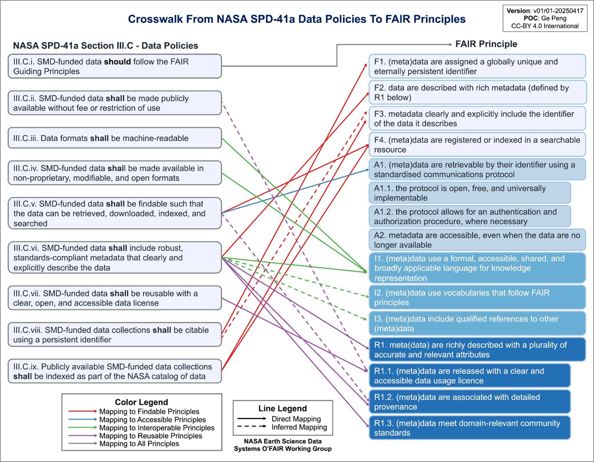
Figure 1
Crosswalk from the data requirements that are defined in the SPD-41a (NASA SMD, 2022) to the FAIR principles that are defined in Wilkinson et al. (2016). Direct mappings from SPD-41a to FAIR are denoted by solid lines, while the dashed lines indicate that the mappings may be inferred or may not always hold. Mappings to Findable/Accessible/Interoperable/Reusable principles are denoted by red/blue/green/purple lines, respectively. Source: Peng et al. (2024a).
The Open, Free, and FAIR Data Working Group (O’FAIR WG) was established in May 2022 under the NASA ESDS Working Groups, now ESDIS Working Groups, to provide practical guidance for aligning NASA’s open and free data products with the FAIR Principles. The O’FAIR WG produced two key outputs: (a) an ‘Inception Report’, offering a high-level overview of community FAIR practices (Peng et al., 2023a), and (b) an O’FAIR Data Guide aiding FAIR-aligned data stewardship (Peng et al., 2024a). In this paper, a data product is defined as a set of data files that can contain multiple parameters and that compose a logically meaningful group of related data (Ramapriyan et al., 2024).
This paper highlights how current data management and stewardship practices for NASA’s Earth science data products align with the FAIR Principles, identifies NASA’s FAIR-enabling resources, outlines implementation challenges, and presents recommendations and strategies for further improving the FAIR compliance, drawing from the two outputs from the O’FAIR WG. Providing practical FAIR implementation guidance enhances the reuse of scientific data products across NASA and the broader community.
Methodology
The methodology for assessing and identifying actionable ways to enhance the FAIRness of NASA’s Earth science data products involves several key steps and approaches, summarized as follows.
Literature review and analysis
The O’FAIR WG began with a high-level literature search, review, and analysis to understand the current landscape of FAIR practices across the scientific data management community, including those from NASA. This included reviewing existing implementation frameworks, FAIR-compliance evaluation metrics and best practices, and community standards, synthesized in the Inception Report (Peng et al., 2023a).
Crosswalks and requirements alignment
The FAIR Principles consist of 15 sub-principles across four FAIR quality dimensions—Findability, Accessibility, Interoperability, and Reusability—and three categories: Data (D), Metadata (M), and Infrastructure (IS) (Peng et al., 2024b). Mapping these principles onto these three categories, 28 category-specific requirements was derived by Peng (2023b), illustrated in Figure 2.
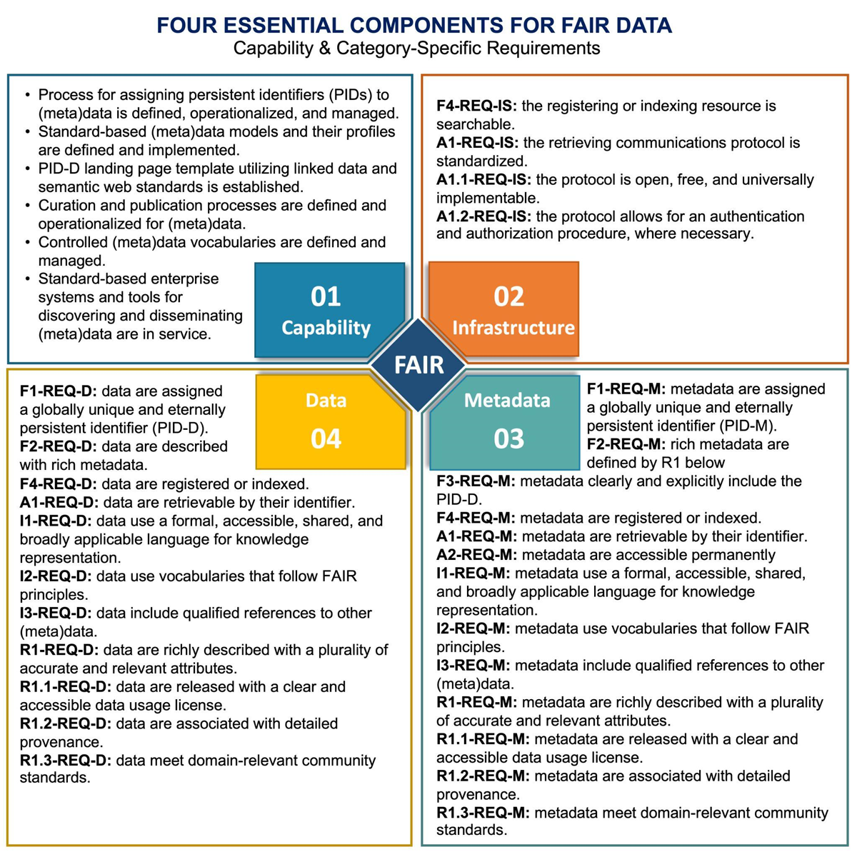
Figure 2
Diagram depicting the four essential components for FAIR data: Capability, Infrastructure, Metadata, and Data. The text boxes provide examples of capabilities and list category-specific FAIR requirements. The naming convention for the requirement identifier is: {FAIR ID}-REQ-{Category ID}, where, {FAIR ID} = [F1, F2, F3, F4; A1, A1.2, A1.2, A2; I1, I2, I3; R1, R1.1, R1.2, R1.3], denoting individual FAIR sub-principles; {Category ID} = [D; M; IS], denoting the Data, Metadata, and Infrastructure category, respectively. Based on Peng (2024).
Crosswalks between the SPD-41a data requirements and the FAIR sub-principles were developed to identify alignment and integration between NASA policy requirements and FAIR expectations, as shown in Figure 1 and discussed in the Introduction.
Scope development and stakeholder engagement
Given the subjective nature of the FAIR Principles, their implementation often varies across disciplines—particularly at the variable level. To navigate this complexity, the evaluation has focused on NASA-funded Earth science data products, that is, at the collection level, within the Common Metadata Repository (CMR), where data management practices are largely standardized across DAACs and disciplines. The assessment focused on identifying FAIR-enabling resources rather than assessing the FAIRness of individual data products and excluded granule- or variable-level variations. The process was systematic but inherently manual and subjective.
The O’FAIR WG mobilized a broad range of expertise—domain and data scientists, specialists in data management and stewardship, data infrastructure technologists, and NASA advisors. This collective knowledge helped identify the challenges and opportunities involved in implementing FAIR-aligned practices for managing and sharing Earth science data products. Participation was assembled through an open call for participation to all members of ESDIS Working Groups, complemented by engaging with NASA data producers and users, DAACs and SIPSs, as well as with the broader geoscience communities. Community engagement within and beyond NASA is critical for clarifying applicability, building consensus on feasibility, validating proposed approaches, and ensuring that the resulting guidance is both practical and relevant (e.g., Peng et al., 2023b; Peng, Downs and NASA ESDS O’FAIR Working Group, 2023; Peng et al., 2024c).
FAIR-enabling resource identification and FAIR-compliance assessment
Existing NASA resources, including metadata tools, data catalogs, and data access mechanisms, were identified and examined to subjectively determine how they support or could be leveraged to ensure or enhance the level of FAIR compliance (FAIRness) of NASA-funded Earth science data products by assessing their roles in terms of findability, accessibility, interoperability, and reusability.
NASA Enterprise FAIR-Enabling Processes and Resources
As demonstrated in Peng (2023a), FAIR sub-principles can be effectively analyzed using a subject-predicate-object model where the ‘predicate’ presents the relationship between the subject and the object, encompassing actionable terms such as ‘are assigned’, ‘are indexed’, and ‘are released with’. Peng et al. (2024b) further emphasized the critical role of repositories and data services in establishing standardized procedures and workflows to support these relationships.
At the policy level, NASA SMD’s Open Data and Information Policy (SPD-41a) codifies that data and information products from NASA-supported missions and research investigations follow the FAIR Principles to ensure their findability, accessibility, interoperability, and reusability.
At the process level, DOIs for Earth science data products are assigned by designated DAACs, following established guidance on metadata requirements, DOI submission, and landing page content (NASA Earthdata, n.d.b). Data products are released via a standardized process (NASA Earthdata, n.d.c). Curated data product-level metadata records based on community metadata standards are ingested into and managed by CMR (NASA Earthdata, n.d.d) and are indexed by the Earthdata Search (EDS) portal, utilizing the controlled and managed Global Change Master Directory (GCMD) keywords for Earth science for faceted discovery (NASA ESDIS, 2016). The established processes and standards provide important enterprise capability for enabling FAIR data, as depicted in the upper left quadrant of Figure 2.
As highlighted in Table 1, these NASA enterprise resources ensure consistent standards across ESDIS and collectively enable the adoption of the FAIR Principles for NASA-funded Earth science data products, as illustrated in Figure 3.
Table 1
A list of NASA Earth science enterprise capabilities.
| NASA ENTERPRISE CAPABILITY | DESCRIPTION |
|---|---|
| Common Metadata Repository (CMR) | CMR is a system that catalogs and manages metadata, and provides search functionality. It is a centralized backend system supporting data and product discovery through NASA’s Earthdata Search portal. The CMR uses an extensible Unified Metadata Model (UMM) which crosswalks to various metadata standards such as ISO 19115-2 and DIF-10, ensuring metadata quality, consistency, and comprehensiveness (NASA ESDIS CMO, 2023). CMR provides an open-source API. |
| Earthdata Login | Earthdata Login is a single-sign-on system that manages Earth data user registration and profile. |
| Earthdata Search (EDS) | EDS is a map web-based tool and an advanced platform that facilitates data search and discovery, visualization, and access. EDS also provides an open-source API. |
| Global Change Master Directory (GCMD) | GCMD is a system that manages and provides access to controlled vocabulary of keywords. GCMD keywords are a set of controlled Earth science vocabularies maintained in the Keyword Management System (KMS), output in RDF, JSON, and XML (NASA ESDIS, 2016). They include various categories such as science keywords, platforms, instruments, data centers, locations, projects, providers, services, and more, each assigned with a unique UUID. |
| Distributed Active Archive Centers (DAACs) | DAACs are primarily discipline-focused repositories that are responsible for acquiring, curating, archiving, managing, distributing, and supporting the use of hosted NASA’s Earth science data. An exception is the ASF DAAC, which is sensor-specific and focused solely on synthetic aperture radar data. DAACs provide data management best practices, vocabularies, tools, and services to support data access and utilization, pertaining to their disciplines and complementary to EDS. They also offer user support and training for data use, tailored to the uniqueness of their data products. |
[i] Acronyms are captured in Appendix A.
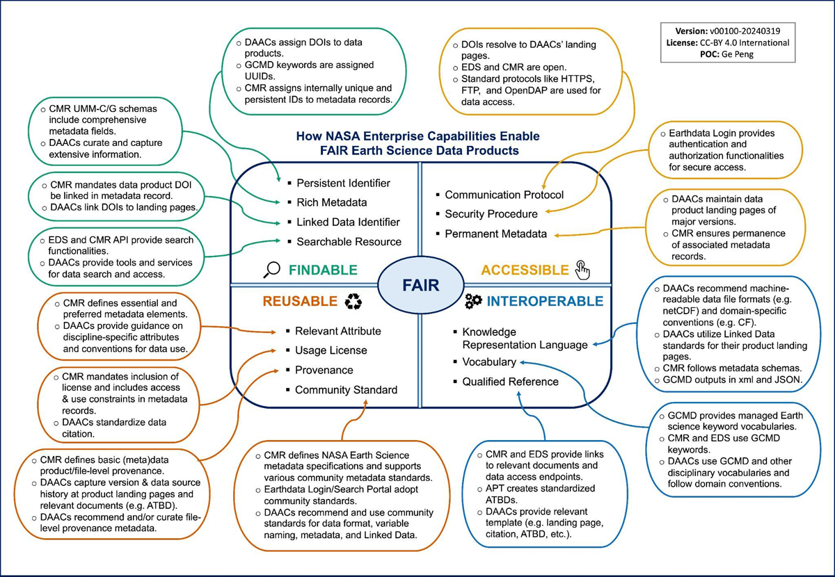
Figure 3
A schematic diagram summarizes how NASA enterprise capabilities enable FAIR earth science data products. The center of the diagram contains four sections, representing the four dimensions of the FAIR Principles. The core concepts of the FAIR sub-principles within each dimension, as defined in Peng et al. (2024b), are listed in each quadrant. Acronyms are captured in Appendix A.
Additionally, the Metadata Management Tool (MMT) allows users to create and submit comprehensive and standardized data product metadata records in the CMR User Acceptance Test (UAT) environment (NASA CMR, 2023; NASA CMR, 2024). The submitted metadata records are ingested into CMR through an internal workflow and indexed with CMR tags to facilitate search and discovery.
Although not shown in Figure 3, individual DAACs also develop vocabularies, tools, and services, such as the Atmospheric Composition Variable Standard Name Convention (ACVSNC), to enhance discipline-specific, variable-level discovery and interoperability (Silverman et al., 2023).
Current State of FAIR-Compliance for NASA Earth Science Data Products
The alignment of category-specific FAIR requirements with NASA’s existing standards, practices, and enterprise capabilities for Earth science data products was evaluated in Peng et al. (2024a). Results are summarized here. FAIR-compliance levels are categorized as fully satisfying all key characteristic requirements, partially meeting them, or only supporting but not meeting any requirements, corresponding to high, intermediate, or minimal compliance, respectively.
Table 2 compares three commonly used identifier types with respect to FAIR F1, focusing on global uniqueness and long-term persistence characteristics. While a local identifier is typically neither globally unique nor eternally persistent, it still qualifies as an assigned identifier, supporting the F1 principle at a minimal level. Using a global unique identifier, such as Universally Unique Identifier (UUID), can elevate compliance to ‘Meeting’.
Table 2
Characteristics of a Digital Object Identifier (DOI), Universally Unique Identifier (UUID), and local identifier (ID), as well as their compliance level to the F1 principle, that is, (meta)data are assigned a globally unique and eternally persistent identifier.
| IDENTIFIER TYPE | DOI | UUID | LOCAL ID |
|---|---|---|---|
| What it is | A globally unique, persistent identifier used to cite and access digital resources (e.g., datasets, publications) | A 128-bit number used to uniquely identify information in distributed systems | A unique identifier used within a specific organization, repository, or system |
| Example | 10.5067/GHGMR-4FJ04 | 8012fda7-3ea4-4ef2-bb4e-0f66d4d9e850 | C1996881146 |
| Globally Unique | Yes | Yes | No |
| Eternally Persistent | Yes | No | No |
| F1 Compliance Level | Satisfying | Meeting | Supporting |
Being findable
Findability aims to enhance the discoverability of digital data. This entails assigning data with globally unique, persistent, and resolvable identifiers, such as DOIs. Moreover, data should be cataloged and described with comprehensive metadata, including linked data identifiers, to facilitate search and discovery.
NASA has invested heavily for decades in making Earth science data discoverable. These efforts have involved establishing standards, developing processes, and building infrastructure capacity. Current ESDIS standards, practices, and capabilities strongly support the principles in the Findability dimension at the data system level (Ramapriyan and Behnke, 2020). Our findings, shown in Table 3, align with these conclusions at the data product level. Table 3 highlights the FAIR-enabling resources that NASA has already implemented (second column) and their estimated FAIR compliance (third column). When requirements are only partially met or supported, corresponding recommendations are proposed for NASA to consider, whose IDs are listed in the fourth column. Most improvements for this dimension focus on better machine-actionability, which will be discussed in more detail in Section ‘Recommendations and Strategic Actions’.
Table 3
A list of category-specific requirement IDs associated with the Findability principles (described in Figure 2), NASA enabling resources and their compliance level, and O’FAIR working group (WG) recommendation identifiers (IDs) along with their level of priority and effort required to implement. Acronyms are captured in Appendix A.
| FAIR-F REQ ID | NASA ENABLING RESOURCES | COMPLIANCE LEVEL (SATISFYING/MEETING/SUPPORTING) | O’FAIR WG RECOMMENDATION ID (PRIORITY/EFFORT) |
|---|---|---|---|
| F1-REQ-D | Data Product DOI; NASA DOI Process | Satisfying | |
| F1-REQ-M | CMR UMM-C ConceptID | Supporting | F-1 (Low/Easy); F-2 (Medium/Moderate) |
| F2-REQ-D | CMR UMM-C Required metadata elements | Meeting | R-2 (Medium/Moderate) |
| F2-REQ-M | CMR UMM-C fields | Supporting | F-3 (Low/Moderate); A-2 (Medium/Easy); R-4 (High/Easy) |
| F3-REQ-M | CMR UMM-C required DOI element; Linked DOI (landing page website; data files) | Satisfying; Compliance level varies by DAACs | I-2 (Medium/Moderate); R-5 (High/Easy) |
| F4-REQ-D | CMR; Earthdata Search | Satisfying | |
| F4-REQ-M | CMR; Earthdata Search | Satisfying | |
| F4-REQ-IS | CMR API; Earthdata Search Portal | Satisfying |
Being accessible
Accessibility requires that data and metadata are resolvable with persistent metadata and accessed through an open, freely available, widely implementable, and standardized communication protocol, capable of accommodating authentication and authorization procedures as needed.
Over the past three decades, NASA has built and refined its infrastructure to deliver open and free Earth science data globally. The existing ESDIS processes, practices, tools, and capabilities satisfy or meet the A1 principles and provide the infrastructure for enhanced access to data to better address user needs and support modern research and applications. In addition to its commitment to preserving data, NASA is also committed to the long-term preservation of metadata, recognizing its importance for data discovery, reuse, and scientific research traceability. Metadata records are managed and stored separately from the actual data sets, keeping them available even if data products are deprecated to ensure continuous access to essential information about the data. The practices on how to cross-reference metadata versions vary by DAAC. The findings are summarized in Table 4.
Table 4
Same as Table 3 except for Accessibility.
| FAIR-A REQ ID | NASA ENABLING RESOURCES | COMPLIANCE LEVEL (SATISFYING/MEETING/SUPPORTING) | O’FAIR WG RECOMMENDATION ID (PRIORITY/EFFORT) |
|---|---|---|---|
| A1-REQ-D | Data product DOI landing page; Worldview; Harmony | Satisfying | |
| A1-REQ-M | CMR/Earthdata Search | Satisfying | |
| A1-REQ-IS | HTTPS; OPeNDAP; CMR API/Earthdata Search Portal; Worldview; Harmony; | Satisfying | |
| A1.1-REQ-IS | HTTPS; OPeNDAP; CMR/Earthdata Search; Harmony; | Satisfying | |
| A1.2-REQ-IS | Earthdata Login System | Satisfying | |
| A2-REQ-M | Version management—Vary by DAACs | Meeting | A-1 (Low/Moderate); A-2 (Medium/Easy) |
Being interoperable
Interoperability strives to enable integration and exchange of data across diverse systems, tools, services, and research domains. This involves structuring data and metadata using standardized and widely accepted data models, formats, and vocabularies, along with references to related data and metadata.
Cross-domains and cross-discipline interoperability are a grand challenge for global science (IOC, 2020). Key facets include semantic interoperability, which ensures shared meaning using ontologies and controlled vocabularies; syntactic interoperability, which relies on standardized structures and encoding rules; technical interoperability, which addresses compatibility of protocols and interfaces; and legal interoperability, which ensures that licensing enables lawful reuse and integration. Formal knowledge representation languages, FAIR vocabularies, and persistent identifiers are essential enablers of machine-actionability.
Optimal data interoperability enables seamless data and information sharing, integration, and exchanges across NASA systems, other agencies that manage Earth science data products, and diverse scientific disciplines.
Interoperability is critical because, even within NASA, limited interoperability among agency data systems can hinder both internal and external stakeholders from effectively discovering, understanding, integrating, accessing, and using valuable scientific data sources (NASA, 2021). Among the FAIR principles, interoperability remains the most challenging.
Overall, NASA’s enterprise capabilities, approved standards, and established best practices support or meet FAIR-Interoperability requirements (Table 5). Current recommendations focus on improving the semantic representation of resources and adopting Linked Data standards to enhance machine-actionability. Additional discussion is provided in Section ‘Recommendations and Strategic Actions’.
Table 5
Same as Table 3 except for Interoperability.
| FAIR-I REQ ID | NASA ENABLING RESOURCES | COMPLIANCE LEVEL (SATISFYING/MEETING/SUPPORTING) | O’FAIR WG RECOMMENDATIONS ID (PRIORITY/EFFORT) |
|---|---|---|---|
| I1-REQ-D | netCDF; HDF; CF; ACDD; RDF; JSON-LD | Meeting; Supporting | I-1 (High/Moderate) |
| I1-REQ-M | CMR UMM-C; GCMD | Meeting | I-4 (High/Easy) |
| I2-REQ-D | CF Standard Names; ACVSNC | Meeting; Supporting | I-1 (High/Moderate) |
| I2-REQ-M | GCMD; CF; ACDD | Supporting | I-3 (Low/Easy); I-5 (High/Moderate) |
| I3-REQ-D | Linked data | Supporting | I-1 (High/Moderate); I-2 (Medium/Moderate); I-6 (High/Moderate) |
| I3-REQ-M | UMM-C elements (AssociatedDOIs and AssociatedURLs) | Supporting | I-6 (High/Moderate); A-2 (Medium/Easy) |
Being reusable
Reusability promotes data and digital resources are comprehensively described so that they can be readily understood, interpreted, and (re)used with minimal efforts. This involves adhering to domain-relevant standards, providing thorough documentation, specifying a clear usage license, and detailing provenance.
NASA’s enterprise capabilities and approved standards and practices generally support or meet FAIR-Reusability requirements (Table 6). One area needing improvement is the explicit inclusion of an open and machine-readable license in metadata. Although NASA ESD has long promoted open and free access to data and publicly posts its data policy, embedding machine-readable licenses directly in metadata of data products and resources, such as GCMD keywords, would further strengthen their FAIR-compliance.
Table 6
Same as Table 3 except for Reusability.
| FAIR-R REQ ID | NASA ENABLING RESOURCES | COMPLIANCE LEVEL (SATISFYING/MEETING/SUPPORTING) | O’FAIR WG RECOMMENDATION ID (PRIORITY/EFFORT) |
|---|---|---|---|
| R1-REQ-D | CMR UMM-C elements; GCMD keywords; netCDF global attributes | Supporting | R-1 (High/Moderate); R-3 (High/Easy) |
| R1-REQ-M | CMR UMM-C required elements; GCMD keywords | Meeting | R-2 (Medium/Moderate); I-3 (Low/Easy); R-4 (High/Easy) |
| R1.1-REQ-D | NASA Data Policy | Supporting | R-3 (High/Easy) |
| R1.1-REQ-M | Publication process of CMR UMM records; GCMD; | Supporting | I-3 (Low/Easy) |
| R1.2-REQ-D | Some of the UMM-C elements; netCDF global attributes | Supporting | R-5 (Medium/Challenging) |
| R1.2-REQ-M | A few of the UMM-C elements | Supporting | R-5 (Medium/Challenging); A-1 (Low/Moderate); A-2 (Medium/Easy) |
| R1.3-REQ-D | netCDF; HDF; GeoTIFF; DPDG; | Meeting | R-1 (High/Moderate) |
| R1.3-REQ-M | UMM (DIF 10; ECHO 10; ISO 19115); CF; ACDD; JSON-LD | Varying: Mostly Meeting; ISO 19,115 & JSON-LD—Satisfying) |
Recommendations and Strategic Actions
The alignment of NASA’s FAIR-enabling standards, practices, workflows, and tools/services for Earth science data products was evaluated as part of developing the O’FAIR practical guidance document (Peng et al., 2024a). When gaps were identified, whether for data products, standards, or practices, the O’FAIR WG proposed actionable recommendations to enhance FAIRness. This process produced 16 recommendations: three for Findability, two for Accessibility, six for Interoperability, and five for Reusability. Recommendations are prioritized as low, medium, or high and implementation effort is characterized as Easy, Moderate, Challenging, or Resource Intensive. This section summarizes those recommendations.
Enhancing findability and accessibility
Overall, NASA Earth science data products managed by DAACs are both findable and accessible to human and machine users. Recommendations include assigning or registering globally unique persistent identifiers for CMR collection-level metadata records (Recommendation F-1), missions/campaigns (Recommendation F-2), and individual data producers and organizations (Recommendation F-3) (Table 7). Additional recommendations support improved association of DOIs across versions within metadata (Recommendation A-1) and a common approach for cross-referencing version information on data product landing pages (Recommendation A-2) (Table 7). Technologies needed for these updates are mature, and the resource needs are low, with moderate efforts expected for implementing Recommendations F-2, F-3, and A-1 due to required procedural development.
Table 7
A list of Recommendation ID (ID), description, the level of criticality in facilitating FAIR compliance and the level of effort or resource needed for implementation for Findability and Accessibility. From Peng et al. (2024a). The naming convention for ID: {FAIR Dimension}-n, where {FAIR Dimension} = [F; A; I; R], respectively, and n is numerical value, running from 1 to 3 for F, 2 for A, 6 for I, and 5 for R, respectively. The level of criticality is classified as low, medium, and high for NASA based on their criticality in facilitating FAIR compliance. The estimated level of effort and resource requirement for implementing a recommendation is categorized as Easy, Moderate, Challenging, or Resource Intensive.
| ID | DESCRIPTION | CRITICALITY/IMPLEMENTATION EFFORT |
|---|---|---|
| F-1 | Assign globally unique identifiers, such as Universally Unique Identifiers (UUIDs) or Archival Resource Keys (ARKs), to each of the CMR ConceptIDs, at least for all the collection ConceptIDs. These identifiers should be managed for their uniqueness and persistence within CMR. | Low/Easy |
| F-2 | Assign and maintain a globally unique and persistent identifier (PID) to the satellite mission or field campaign and ensure that the PID is resolved to a permanent mission/campaign landing page and explicitly embedded as structured, machine-actionable metadata, utilizing standards for linked data on the web. | Medium/Moderate |
| F-3 | Register with appropriate unique and persistent identifier (PID) systems (e.g., data producers/curators with ORCID.org and organizations with ROR.org or re3data.org). Those PIDs should be used and included in relevant metadata and documents to denote uniquely the individual data producers and organizations. | Low/Moderate |
| A-1 | Leverage the DataCite metadata schema to establish a common approach to associate DOIs of different versions of a data product and extend the Unified Metadata Model (UMM) to establish associations among data product metadata records. | Low/Moderate |
| A-2 | The ESDIS CMR team and the DAACs work together to develop a common approach to cross-reference different versions of a data product and provide versioning information on data product landing pages. | Medium/Easy |
Strengthening interoperability
While NASA Earth science data products generally support machine-actionability with syntactic interoperability, interoperability remains the area with the greatest need for improvement. Several recommendations target improved semantic representation of data and metadata and enhanced linked data on the web, leveraging community standards (Recommendations I-1 through I-6) (Table 8). As necessary technologies are maturing, ESDIS-level strategies or templates will be required, leading to moderate or challenging implementation efforts. Recommendations I-3 and I-4 are exceptions, requiring minimal resources.
Table 8
Same as Table 7 except for Interoperability.
| ID | DESCRIPTION | CRITICALITY/IMPLEMENTATION EFFORT |
|---|---|---|
| I-1 | Develop actionable strategies and guidelines to enable or enhance machine-actionability, utilizing community Linked Data standards and the semantic representation of NASA Earth science digital data and other associated digital resources. | High/Challenge |
| I-2 | Data product DOI (collection) should be included in individual data files (granules) in a machine-actionable fashion, if appropriate. | Medium/Moderate |
| I-3 | Release the GCMD keywords collection, and release the collection as it changes, with a formal CC0+Attribution Request usage license and link it to the GCMD landing page with the recommended citation. The recommended citation should include the license in a machine-actionable fashion. | Low/Easy |
| I-4 | Utilize GCMD Science Keywords (including their URIs) in metadata to describe their data products, when it is appropriate to do so. | High/Easy |
| I-5 | Explore community standards, develop actionable strategies to improve the semantic representation of NASA vocabularies, and support their implementation for GCMD science keywords, utilizing relevant ontologies like those in SWEET. | High/Moderate |
| I-6 | Develop an ESDIS-wide template for defining a set of core fields as qualified references and provide best practices of embedding them in data product landing pages as linked data and that of including them in CMR data product level metadata records. | High/Moderate |
Improving reusability
NASA’s enterprise capabilities, standards, and best practices largely support or meet FAIR-Reusability requirements. Recommendations encourage the use of the NASA Earth Science Data Product Development Guide (DPDG) (Ramapriyan et al., 2024) (Recommendation R-1) and the pyQuARC API for ensuring metadata quality (Recommendation R-2). The WG also recommends including a machine-readable Creative Commons license in CMR UMM-C (Recommendation R-3), linking the DOI to its landing page (Recommendation R-4), and capturing more robust provenance within CMR UMM-C and/or UMM-G (Recommendation R-5) (Table 9).
Table 9
Same as Table 7 except for Reusability.
| ID | DESCRIPTION | CRITICALITY/IMPLEMENTATION EFFORT |
|---|---|---|
| R-1 | Data producers should follow the recommendations provided in the Data Product Development Guide (DPDG) document. Data producers should also raise questions and provide feedback when issues are encountered in application of the DPDG. | High/Moderate |
| R-2 | Data producers and DAACs should utilize the pyQuARC API to evaluate the consistency, completeness and robustness of their data product-level metadata records and should seek solutions to the shortcomings identified during the process. | Medium/Moderate |
| R-3 | A machine-readable Creative Commons data usage license such as that from the Software Package Data Exchange (SPDX) Specification (https://spdx.org/licenses/) should be explicitly included in a mandatory CMR UMM-C element. | High/Easy |
| R-4 | The data product DOI should be a mandatory, machine-readable, and linked-data element on its landing page. | High/Easy |
| R-5 | Establish an ESDIS procedure/task force to develop technical and practical specifications for capturing a more robust provenance of NASA Earth science data products in CMR UMM-C and/or UMM-G. | Medium/Challenging |
Discussion
NASA’s efforts to align its Earth science data stewardship with the FAIR Principles have revealed both substantial achievements and areas requiring continued attention. While enterprise policies, standards, and tools provide a solid foundation, the O’FAIR WG identified several persistent challenges and future opportunities to further strengthen FAIR implementation across NASA’s distributed data ecosystem.
Challenges
The FAIR Principles offer high-level domain-agnostic and technology-agnostic guidelines (Mons et al., 2017; Wilkinson et al., 2019; Wilkinson et al., 2022). However, domain, technology, and application dependencies need to be considered when implementing the FAIR Principles (e.g., Bahim et al., 2020; Jacobsen et al., 2020; Peters-von Gehlen et al., 2022; Wittenburg and Strawn, 2018).
A significant challenge involves defining and maintaining ‘rich’ and comprehensive metadata that are sufficient for discovery, interpretation, and reuse across the wide diversity of NASA’s Earth science data holdings. Ensuring metadata completeness and consistency efficiently and at scale remains difficult, particularly when extending coverage to variable-level metadata and controlled vocabularies. Establishing and maintaining these vocabularies across disciplines is labor-intensive and technically demanding.
Interoperability gaps also remain a central issue. Integrating diverse data formats and ensuring data compatibility across systems requires ongoing alignment of standards and formats. The integration of Linked Data and semantic web technologies—needed to expose datasets, metadata, vocabularies, and licenses as interlinked web resources that support machine-actionability—lags the maturity of the technologies themselves. Additionally, resource constraints limit the ability to fully implement and maintain FAIR-aligned processes across all NASA centers and data repositories. Achieving comprehensive FAIR compliance requires sustained funding, staffing, and coordination amid competing priorities. Finally, maintaining alignment with evolving data policies and standards is an ongoing challenge, as new federal requirements and community expectations continue to emerge.
It is important to note that these challenges are broadly relevant across the global scientific data community and are not limited to NASA.
Future directions
To address these challenges, several strategies can enhance NASA’s ability to scale and sustain FAIR implementation. Continuing to advance enterprise capabilities through emerging technologies such as Artificial Intelligence (AI) and Machine Learning (ML) offers promising opportunities to automate data curation, improve metadata quality and consistency, and enhance scalability. These technologies can also support intelligent search, anomaly detection, and personalized user experiences.
Ongoing collaboration with domestic and international partners—including NOAA, ESA, and WMO—will remain essential for advancing shared standards and interoperability across organizations managing Earth observation data. Active participation in community efforts to develop variable-level metadata standards, such as those coordinated by OGC, WMO, RDA, and CODATA, will strengthen interoperability at a global scale and promote consistency across disciplines.
Building on prior community efforts, developing ESDIS-wide tools and metrics tailored to NASA ESDIS’s data systems and requirements for automated FAIR compliance assessment will help streamline the evaluation process across ESDIS. Likewise, we can strive for efficiency by developing a dashboard for reporting evidence-based FAIR-compliance and identifying additional areas for improvement when and where appropriate.
Additionally, providing user training and support, integrating user feedback into tool and service development, and refining data policies as technologies and practices evolve, as NASA has been doing for many decades, will enhance long-term sustainability. These steps, together with continued investment in enterprise infrastructure and community engagement, will enable NASA to advance toward comprehensive, scalable FAIR implementation across its Earth science data systems.
Conclusion
NASA’s SMD science information policy (SPD-41a), grounded in US laws and agency policies, codifies that all SMD-funded data products follow the FAIR Principles. Ensuring FAIR compliance is crucial for effective management and use of NASA Earth science data. Evaluating the level of FAIR compliance of data products is essential to demonstrate their alignment with US laws and agency policies. The paper summarizes outcomes of an ESDIS work group subjectively evaluating how NASA’s standards and practices align with FAIR.
NASA Earth Science Division’s long-standing commitment to sharing of their open and free data is evident by its development of robust metadata management systems and standards, data access tools, controlled keywords vocabulary services, and support for data discovery and use. Enterprise resources and tools such as the CMR, Earthdata Search, and the GCMD keywords strengthen data findability. Data accessibility is supported with open standards like HTTPS, data portals like Earthdata Search, and services like Harmony, OPeNDAP, and THREDDS. Interoperability is facilitated using machine-readable data file formats (e.g., netCDF), standardized metadata models (e.g., UMM, ISO 19115), metadata conventions (e.g., CF and ACDD), and managed vocabularies (e.g., GCMD). While challenges remain, particularly in machine-actionability, efforts are already underway. Recent updates to DOI and Associated DOI fields in CMR and the UMM metadata model reflect progress related to Recommendation A-1 and assigning a CC0 license to GCMD keywords aligns with Recommendation I-3.
Advancing FAIR implementation benefits from balancing a centralized, top-down approach that strengthens enterprise-level capabilities and processes with a decentralized, bottom-up approach driven by discipline-specific needs and community practices. Navigating the tension between convergence (to enable machine-actionality) and divergence (to support domain-, variable-specificity) remains at the core of ensuring and advancing FAIR compliance.
We emphasize the benefits to leverage NASA’s existing enterprise resources and community standards and highlight the importance of establishing capacity at the enterprise level, such as a centralized metadata management system for standards-based metadata records (CMR), an open discovery protocol (Earthdata Search Portal), and managed vocabularies (GCMD keywords). As technologies and standards evolve, continued revisions will be essential as has been the case for decades within ESDIS.
The O’FAIR WG recommendation will help NASA further enhance the FAIRness of its Earth science data products, ensuring they remain valuable and readily usable by both the global scientific community and the general public. These recommendations also offer actionable guidance for other organizations seeking to improve FAIR-aligned capabilities for their own data products and services.
Appendices
Appendix A. Acronyms
ACDD—Attribute Convention for Dataset Discovery
ACVSNC—Atmospheric Composition Variable Standard Name Convention
AI—Artificial Intelligence
ARK—Archival Resource Key
ASF—Alaska Satellite Facility
CF—Climate and Forecast (metadata conventions)
CMR—Common Metadata Repository
CODATA—Committee on Data of the International Science Council
DAAC—Distributed Active Archive Center
DIF—Directory Interchange Format
DOI—Digital Object Identifier
DPDG—Data Product Development Guide
ECHO—Earth Observing System Clearinghouse
EDS—Earthdata Search
ESA—European Space Agency
ESD—Earth Science Division
ESDIS—Earth Science Data and Information System
ESDS—Earth Science Data Systems
FY—Fiscal Year
GCMD—Global Change Master Directory
GeoTIFF—Geographic Tagged Image File Format
HDF—Hierarchical Data Format
ISO—International Organization for Standardization
JPL—Jet Propulsion Laboratory
JSON-LD—JavaScript Object Notation for Linked Data
KMS—Keyword Management System
ML—Machine Learning
MMT—Metadata Management Tool
NASA—National Aeronautics and Space Administration
netCDF—Network Common Data Form
NOAA—National Oceanic and Atmospheric Administration
OGC—Open Geospatial Consortium
OPeNDAP—Open-source Project for a Network Data Access Protocol
ORCID—Open Researcher and Contributor ID
RDA—Research Data Alliance
RDF—Resource Description Framework
ROSES—Research Opportunities in Space and Earth Science
ROR—Research Organization Registry
SIPS—Science Investigator-led Processing System
SMD—Science Mission Directorate
SPD-41a—Scientific Information Policy Document 41a
SPDX—Software Package Data Exchange
THREDDS—Thematic Real-time Environmental Distributed Data Services
UAT—User Acceptance Test
UMM—Unified Metadata Model
UUID—Universally Unique Identifier
WG—Working Group
WMO—World Meteorological Organization
XML—Extensible Markup Language
Acknowledgements
We are grateful to the members of the O’FAIR WG for their valuable contributions and active participation. Support from NASA ESDIS Working Groups, NASA SMD Office of Chief Science Data Officer (OCSDO), the ESDIS Project, the Interagency Implementation and Advanced Concepts Team (IMPACT) Project, the DAACs, and affiliated NASA SMD-funded projects, for example, Making Earth System Data Records for Use in Research Environments (MEaSUREs) and Advanced Communication Capabilities for Exploration and Science Systems (ACCESS), was essential to enabling this work.
Special thanks to Steve Olding for supporting monthly WG teleconferences and facilitating communication with the ESDIS Project. We also thank Robert Downs for serving as the co-chair and his valuable contributions; Mark Parsons for his insightful input; Shawn Smith for sharing perspectives on marine data management, and Sandra Blevins for serving as the ESDIS POC and her valuable feedback on the initial draft.
We appreciate Tyler Stevens for information related to implementation of the O’FAIR recommendations and constructive comments from Sara Lubkin, Jessica Burnett, and two anonymous reviewers, which helped improve the clarity and conciseness of the paper.
Contents from the O’FAIR WG Inception Report (Peng et al., 2023a) and the Guide document (Peng et al., 2024a) are reused in this paper.
Competing Interests
The authors have no competing interests to declare.
Disclaimer
The work was carried out across multiple United States government-funded institutions under contracts with NASA (noted in Funding Information). Government sponsorship is acknowledged. However, the opinions expressed in this paper are solely those of the authors and do not constitute or imply the endorsement by NASA and the affiliated institutions. The funders had no role in the design of the study; in the collection, analyses, or interpretation of data; in the writing of the manuscript; or in the decision to publish the results.
Author Contributions
GP drafted the manuscript based on the outcomes of the O’FAIR WG. All authors contributed to its review and refinement.
Author Information
All authors were contributing members of the Open, Free, and FAIR Working Group (O’FAIR WG) within NASA’s Earth Science Data Systems (ESDS) Program. They represent NASA’s discipline-oriented data centers, ESDS projects, and NASA SMD-funded scientific data and services initiatives. Collectively, their expertise spans data stewardship, production, management and use, technology development, and service provision, ensuring diverse perspectives across the data product lifecycle.