
Table 1
List of the species and their conservation status occurring in Alaskan waters. Last column shows the individual animals bycaught, as reported in the NOAA National Bycatch Report amended in 2019 regarding data for 2015 (Benaka et al., 2019). For some species no data are shown, and for other species (sooty shearwater, glaucous-winged gull and red-legged kittiwake) the data presented here refer not to species individual bycaught but to higher taxonomic level, respectively, Procellariidae (two species), Laridae (one species) and Rissa (one species). These data refer to all fishery typologies in Alaskan waters. Only for the short-tailed albatross, the data are for, 2014, and the individuals caught in the Bering Sea/Aleutian Islands region. For marine mammals, the dataset is from 2011 to 2015 (IUCN; Benaka et al., 2019, Tables: 5.5.2–5.7.1–5.7.2). Taxonomic serial numbers (TSN) are reported from the Integrated Taxonomic Information System (ITIS) website (www.itis.gov). IUCN: https://www.iucnredlist.org/. ESA: https://www.fws.gov/law/endangered-species-act.
| # AND COMMON NAME | SCIENTIFIC NAME (TAXONOMIC SERIAL NUMBER TSN FROM ITIS.gov) | ALASKAN WATCHLIST STATUS (2017) | IUCN STATUS | ENDANGERED SPECIES ACTSTATUS | BYCAUGHT INDIVIDUALS |
|---|---|---|---|---|---|
| 1. Killer whales | Orcinus orca (180469) | Data Deficient | Endangered | 1.0 | |
| 2. Pacific white-sided dolphins | Lagenorhynchus obliquidens (180444) | Least Concern | |||
| 3. Harbor porpoises | Phocoena phocoena (180473) | Least Concern | |||
| 4. Beluga whales | Delphinapterus leucas (180483) | Least Concern | Endangered | 0.21 | |
| 5. Red-legged kittiwake | Rissa brevirostris (176845) | Declining (Red list) | Vulnerable | 12.0 | |
| 6. Glaucous-winged gull | Larus glaucescens (176814) | Declining in various areas | Least Concern | 1,244.0 | |
| 7. Sooty shearwater | Ardenna grisea (174553) | Declining | Near Threatened | 377.0 | |
| 8. Northern fulmar | Fulmarus glacialis (174536) | Least Concern | 3,430.0 | ||
| 9. Short-tailed albatross | Phoebastria albatrus (554377) | Depressed (Red list) | Vulnerable | Endangered | 9.0 |
| 10. Black-footed albatross | Phoebastria nigripes (554379) | Near Threatened | 359.0 |
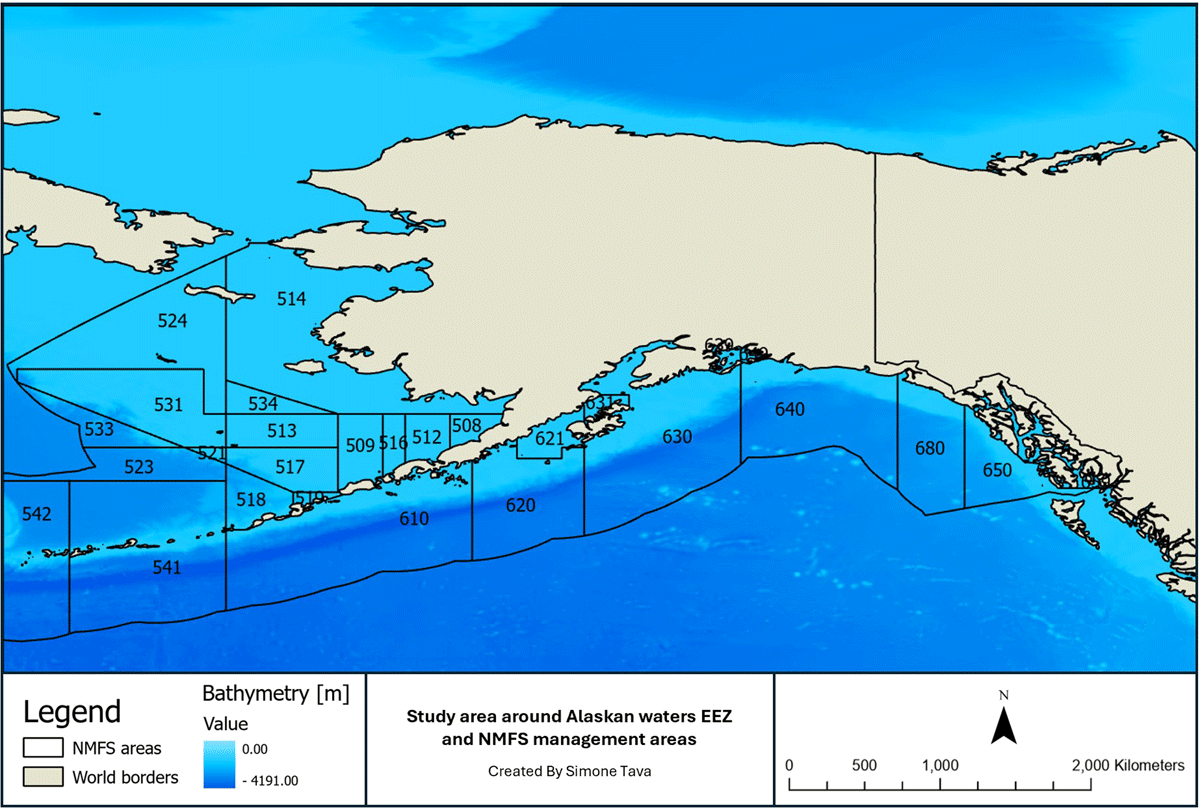
Figure 1
Study area within Alaska’s Exclusive Economic Zones (EEZ) from National Marine Fisheries Service (NMFS). Management areas from 509 to 534 belong to the Bering Sea, Aleutian Islands are 541 and 542, Gulf of Alaska is from 610 to 680. The map is obtained from the manuscript of Dietrich, Parrish and Melvin (2009).
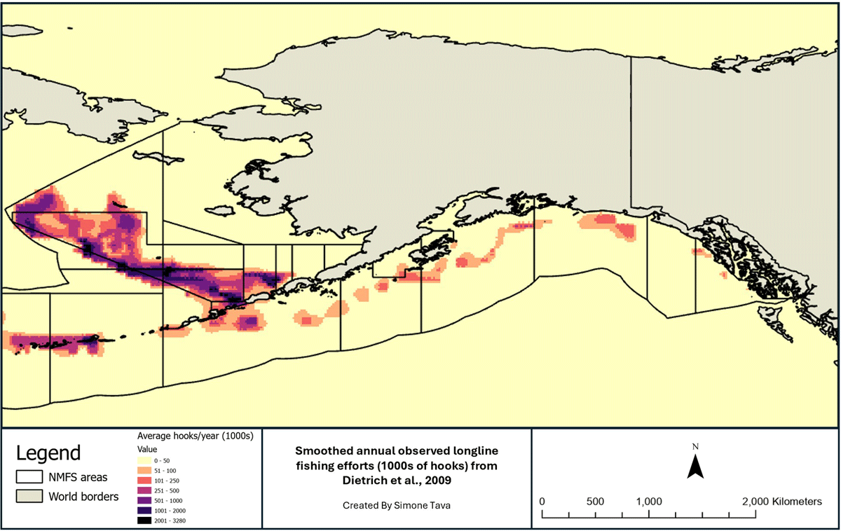
Figure 2
Raw fishing effort as average hooks/year within the study area digitized from Dietrich, Parrish and Melvin (2009) manuscript and smoothed for the study area.
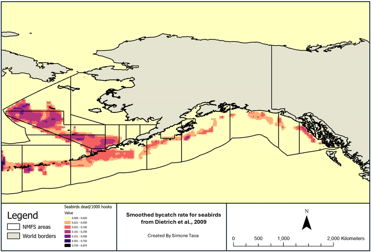
Figure 3
Raw bycatch rate, obtained by the number of seabirds dead per 1,000 hooks of seabirds digitized from manuscript of Dietrich, Parrish and Melvin (2009) and smoothed for the study area.
Table 2
Environmental predictors and sources.
| PREDICTOR | SOURCE | REFERENCE | GRID SPACING (°) |
|---|---|---|---|
| Sea Surface Temperature (SST) [°C] | NOAA World Ocean Atlas (WOA) | Reagan et al., 2024 | 0.250 |
| Nitrate [µmol/kg] | NOAA World Ocean Atlas (WOA) | Reagan et al., 2024 | 1 |
| Dissolved Oxygen [µmol/kg] | NOAA World Ocean Atlas (WOA) | Reagan et al., 2024 | 1 |
| Silicate [µmol/kg] | NOAA World Ocean Atlas (WOA) | Reagan et al., 2024 | 1 |
| Phosphate [µmol/kg] | NOAA World Ocean Atlas (WOA) | Reagan et al., 2024 | 1 |
| Sea Surface Salinity (SSS) | NOAA World Ocean Atlas (WOA) | Reagan et al., 2024 | 0.250 |
| Bathymetry [m] | ETOPO Global Relief Model | www.ncei.noaa.gov | NA |
| Distance from the coast [°] | S. Tava | ArcGIS calculation | NA |
| Coastline | ESRI | www.arcgis.com | NA |
Table 3
Species affected by our modelled bycatch scenario in the present and future (%).
| SPECIES | PRESENT | FUTURE (2050) |
|---|---|---|
| Short-tailed albatross | 100.00% (1) | 100.00% (1) |
| Red-legged kittiwake | 36.77% (2) | 35.44% (6) |
| Killer whale | 20.56% (3) | 56.37% (3) |
| Black-footed albatross | 6.00% (4) | 68.01% (2) |
| Harbor porpoise | 5.94% (5) | 39.34% (5) |
| Sooty shearwater | 5.15% (6) | 24.23% (8) |
| Glaucous-winged gull | 4.75% (7) | 52.59% (4) |
| Pacific white-sided dolphin | 4.46% (8) | 29.66% (7) |
| Northern fulmar | 2.72% (9) | 14.84% (9) |
| Beluga whale | 0.00% (10) | 0.00% (10) |
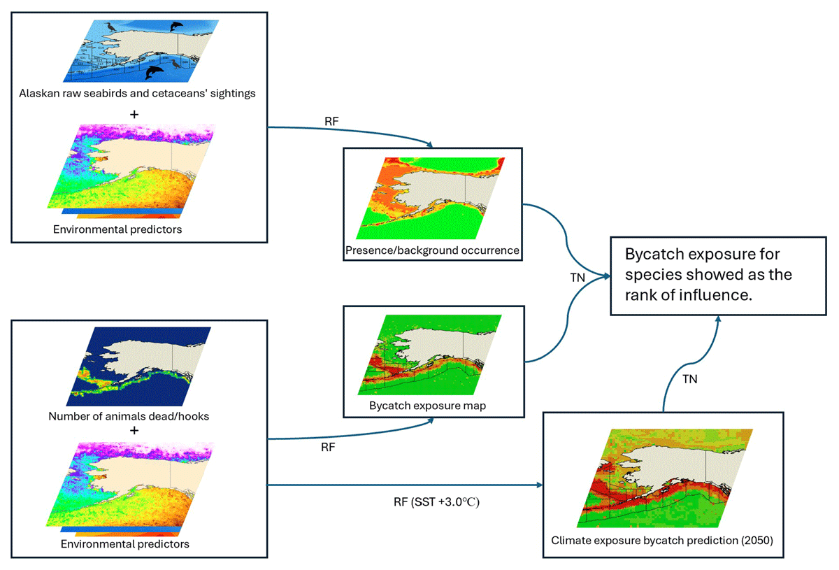
Figure 4
Workflow and steps used in the study, from the raw points of species in Alaskan waters to the predictions of the bycatch of present and future. The lines which connect the workflow stand for the models used: RF = Random Forest; TN = TreeNet.
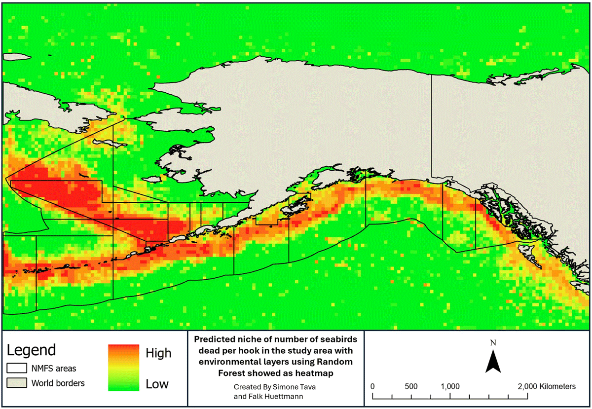
Figure 5
Predicted bycatch exposure assessment for predicted ecological niche model pixels with seabirds and marine mammals revised using environmental predictors and presented as a heatmap. RIO values range from Low (0.0) to High (6.26).
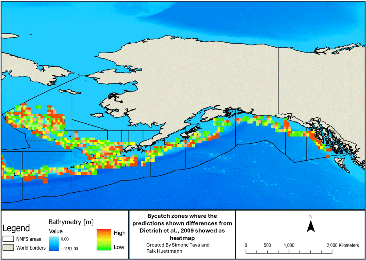
Figure 6
Differential map from our assessment and bycatch and the one found in literature (Dietrich, Parrish and Melvin, 2009) presented as a heatmap. RIO values range from Low (0.0000001) to High (2.550000). With this map we intended to show which of the areas are affected by an underestimation of bycatch, going from values around zero (if pixels have not an underestimation) to values around 2.55 (pixels have highly bycatch underestimation).
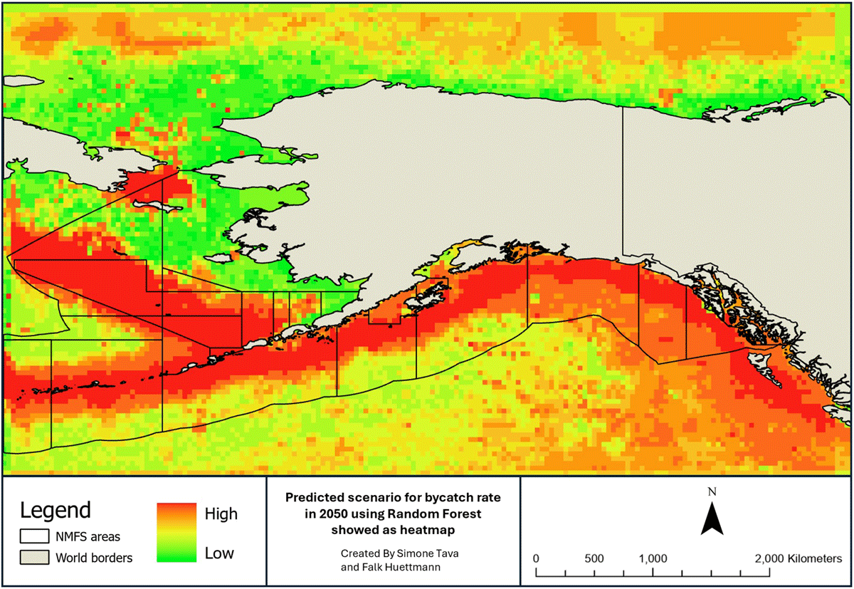
Figure 7
Scenario created from the bycatch exposure for 2050 using the eight environmental predictors and considering a raising in Sea Surface Temperature of 3.0°C. The map is presented as a heatmap. RIO values range from Low (0.000) to High (4.574).
Table 4
Fishery and bycatch data in the Exclusive Economic Zone of Alaska and under the Magnuson-Stevens Act.
| DATASET | DATASET DESCRIPTION | DATA FORMAT | METADATA | PRESENCE IN MAGNUSON-STEVENS ACT |
|---|---|---|---|---|
| Bycatch spatial data (Dietrich, Parrish and Melvin, 2009) | Spatial bycatch data of seabirds in Alaskan EEZ | Digitized data This work aimed to have it in GEOTIFF and shapefile | No | Yes |
| Predicted bycatch map (this work) | Prediction of influence of bycatch on marine megafauna | GEOTIFF and shapefile | Yes (this work) | No (to be included) |
| Predictors | Variables used to create distribution maps | GEOTIFF and shapefile | Yes (this work) | No (to be included) |
| Future prediction | Prediction of influence of bycatch on marine megafauna for, 2050 | GEOTIFF and shapefile | Yes (this work) | No (to be included) |