
1. Introduction
In the pursuit of sustainable development and a resilient future for Africa, the integration of geoinformatics and Earth observation (EO) has emerged as a transformative approach (Ramachandran et al., 2021). At the heart of this approach lies Open Science (OS), a paradigm that fosters collaboration among researchers and accelerates scientific advancement by promoting the sharing of knowledge and resources (Okafor et al., 2022). Open Science extends beyond the mere exchange of software, data, and publications to encompass policies, technologies, systems, and protocols, thereby enhancing capacity building, crowdsourcing, and cooperation in research and development on a global scale (Calatrava et al., 2023, Ibrahim and Elramly, 2016; Ibrahim and Elramly, 2017). By facilitating open access to geospatial data, particularly remote sensing data, OS offers significant economic and societal benefits, aligning with the African Union’s Agenda 2063 goals (AU, 2015). Furthermore, the development of tools that enable faster and more effective decision-making is crucial for enhancing the resilience of Africa’s systems (Roberts, 2021). With the advent of artificial intelligence (AI), there is unprecedented potential to revolutionize OS and geoinformatics, making them more efficient, accessible, and collaborative (Gevaert, 2022; Miralles et al., 2023; Nost & Colven, 2022). It is imperative to develop government agendas in developing countries and raise awareness among governments and leaders to harness these advancements effectively. The promotion of OS aims to make geospatial data and tools more accessible to African researchers and policymakers, addressing critical challenges such as climate change and food insecurity while fostering collaboration between African and international researchers. In many academic domains, OS facilitates innovation and commercialization by enhancing the reusability and reproducibility of research outputs, enabling the validation and replication of findings, and providing a framework for future developments. This paper explores the collaborative efforts, international funding, and partnerships required among African countries and global stakeholders to achieve the successful adoption and implementation of OS and geospatial technologies. By building upon the concept of open commons (Grossman, 2023), which underscores the need for ethical principles in the innovative use of scientific knowledge (Capps, 2021), and leveraging open innovation to foster collaboration (Wendzel et al., 2017), the goal is to improve policy-making and advance the African Union’s Agenda 2063 and the Sustainable Development Goals (SDGs) (Allen et al., 2021).
2. Contribution to Theory and Research Gap
This paper addresses the critical research gap concerning the application of OS and geoinformatics in informing policy-making and promoting sustainable development in Africa, with a focus on Agenda-2063.
This paper tries to answer the question of how to use OS and geoinformatics to inform policy-making and promote sustainable development in Africa based on Agenda 2063.
It answers this question by highlighting the benefits of open data for economic and societal advancement. It proposes strategic recommendations and outlining practical implementations and challenges for African governments to adopt and implement OS and Geoinformatics, emphasizing international collaboration through African Open Science Platform (AOSP) (https://aosp.org.za/). It proposes solutions to address implementation challenges. The paper offers an action plan and framework designed to leverage these technologies to advance the African Union’s Agenda-2063 and the Sustainable Development Goals (SDGs), thereby bridging the gap between theoretical knowledge and practical application. Moreover, it examines the potential of AI to augment OS and geoinformatics, proposing solutions to address implementation challenges.
3. Methodology
This paper employs a scoping methodology to explore how to use OS and geoinformatics to inform policy-making and promote sustainable development in Africa based on Agenda 2063? This research review follows a five-step process: formulating a research question, identifying relevant studies, selecting studies, charting the data, and summarizing and reporting the findings (Arksey and O’Malley, 2005). This structured approach enables researchers to assess the extent of OS and geoinformatics utilization in the field and identify gaps and challenges in existing knowledge.
3.1 Identification of studies via databases
The search for relevant literature was conducted using SCOPUS database, based on specific criteria. The search was limited to abstracts and full-text articles published between 1992 and 2023 because OS movement has started in 1991 with arXiv.org as a novel repository for economics where scientists can publish their research for free (Miedema, 2022).
The criteria (Figure 1) included keywords such as ‘open science,’ ‘sustainable development,’ ‘geoinformatics,’ ‘SDG,’ and ‘Agenda 2063.’ Papers that did not discuss OS practices or did not contribute to the SDGs were excluded from the review.
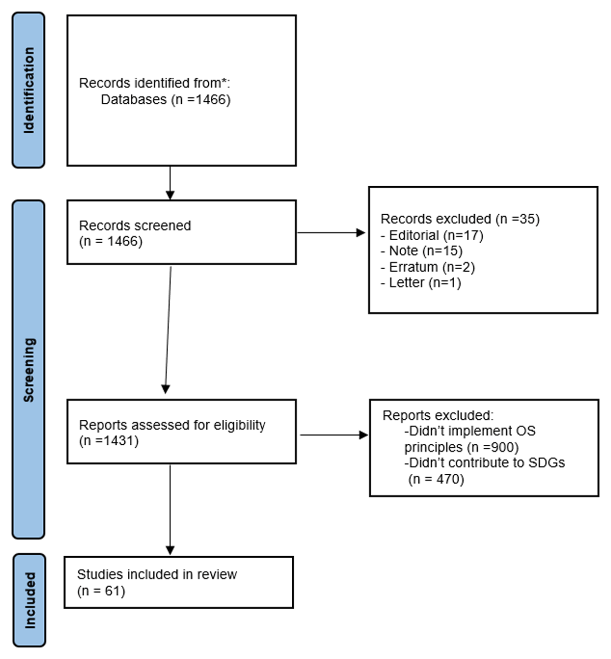
Figure 1
Identification of studies via databases.
3.2 International research collaboration
AOSP is an initiative designed to promote OS across the continent by linking African member states through regional nodes. As of 2023, AOSP has appointed three regional nodes that are connected to a continental hub hosted at the National Research Foundation in South Africa. This hub aims to contribute to strategic science priorities for Africa. Establishing trust and cohesion between members who have never collaborated before is essential for working together toward socially and scientifically meaningful goals with clear benefits. Partnerships and alliances, especially in cross-industry innovation, are crucial (Friesike et al., 2015). Being part of an alliance with a wide range of members and varied expertise offers the advantage of lowering investment risks (Tay, 2021). AOSP, along with its regional nodes, focus on key priorities that address challenges facing Africa, such as disease prevention and control, improved intra-Africa research collaboration, environmental protection, and other significant issues. Success in achieving these priorities depends on increased rates of wealth creation in Africa and its member states.
3.3 Open science policies in North Africa and the Middle East
Several international cooperatives, such as UNESCO, the International Science Council (ISC), and the European Commission (EC), are actively working on OS recommendations and policies. For instance, the ISC has fostered OS policies and projects in Africa by funding and establishing partnerships (Drach et al., 2022; Okafor et al., 2022). Currently, there is no formal OS policy in North Africa (NA) and the Middle East (ME) countries (Figure 2). However, some initiatives are driven by higher education and research institutions. Examples include the open-source community at Ain Shams University in Egypt, the Egypt OS community (https://osc-international.com/osc-egypt/), and initiatives by National Authority for Remote Sensing and Space Sciences (NARSS) in response to new development demands. Additionally, in the Arab states, there are initiatives like Saudi Arabia OS community (https://osc-ksa.com/). The figure indicates that no government in the region publishes data, whether open or closed, to enhance social policy or government accountability.
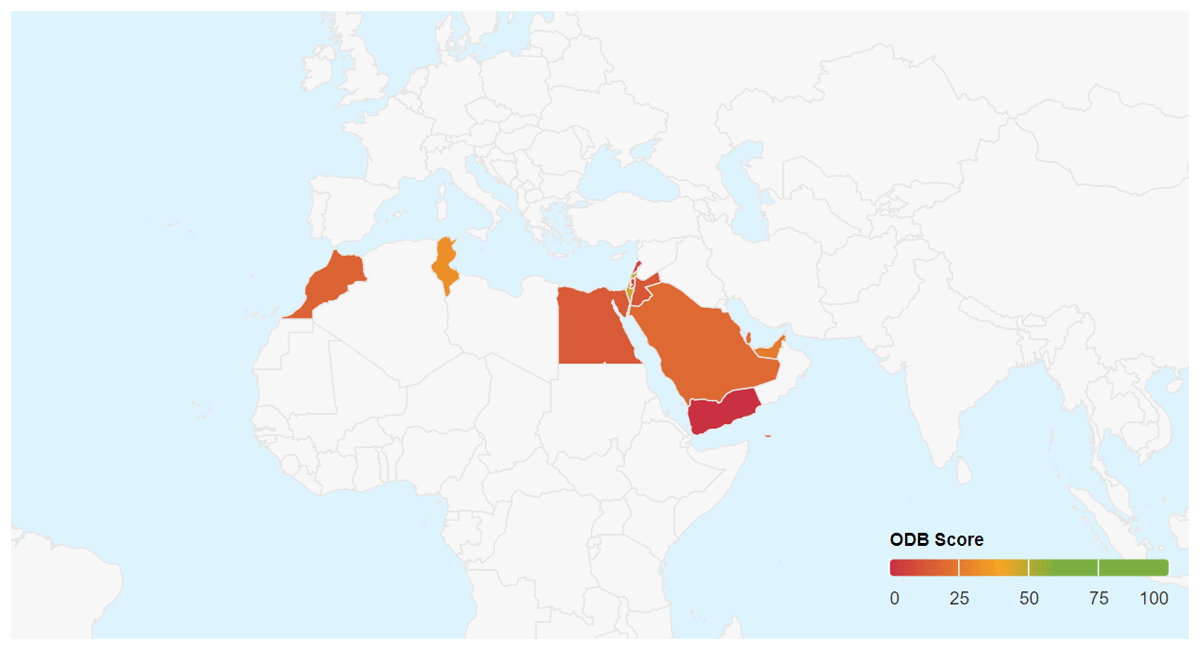
Figure 2
Open Data Barometer Fourth Edition for NA and ME (Source: https://opendatabarometer.org/4thedition/regional-snapshot/middle-east-north-africa/).
3.4 Community development
OS communities and alliances are collaborative learning environments that facilitate interaction, and mutual learning among researchers with varying degrees of experience., Supporting the continuous creation of OS infrastructure, innovations, and policies, enabling these groups to spread out OS approaches (Bertram et al., 2023). Researchers often form OS groups in a bottom-up manner, but increasingly, organizations are supporting these initiatives by offering financial backing and targeting individuals interested in OS who have not yet adopted its practices (Bertram et al., 2023). Initiatives like the international network of OS and scholarship communities provide resources, such as a starter kit, to help researchers establish local OS communities at their institutions (www.startyourosc.com). Despite their advantages, OS practices can be challenging to implement. Therefore, institutional support and incentives at multiple levels are crucial for making OS viable (Bertram et al., 2023). Several key stakeholders have been identified as a basis for promoting and strengthening OS and Geoinformatics in Africa which include; (a)Ministries and directories responsible for education, science, technology and innovation, (b)Funding institutions, (c)Institutional leaders, (d)National Education Research Network, (h) ‘Regional Center for Remote Sensing of North Africa States’.
The question is, ‘Do these existing organizations in North Africa have such potential and capacity to drive the conversations around a holistic OS policy for Africa?’ Through the African Regional Multi-stakeholder meeting on OS in 2020, the African Union Commission made a good step by bringing stakeholders and experts together on OS but unfortunately, there was no roadmap for accomplishing the set goals declared during the meeting (UNESCO, 2021). The African agenda (2063) and the global SDGs would be far from being fulfilled in Africa unless OS is prioritized through a working policy for Africa. The African Institutions frequently require guidance; in the form of an action plan that will direct them to start the process of implementing the UNESCO principles. This paper offers a roadmap (Table 1) identifying the framework and strategy to serve as guidelines for government officials to transfer the principles into a set of actions that might assist in improving open data practices.
Table 1
Action plan and framework that helps African governments to take actions towards successful adoption and implementation of OS and Geoinformatics.
| 1. PLANNING STAGE | 2. EXPLORING STAGE | 3. IMPLEMENTATION STAGE | 4. REFINING STAGE |
|---|---|---|---|
|
|
|
|
| 5. DATA MANAGEMENT STAGE | 6. COMMUNITY SUPPORT & ENGAGEMENT | 7. CAPACITY DEVELOPMENT | 8. STRATEGY AND CHANGE MANAGEMENT |
|
|
|
|
The primary goal is to embed a culture of openness in governments sustainably and effectively. Table 2 provides an estimated cost of implementing OS and geoinformatics activities in Africa, though the actual cost will vary based on several factors. For instance, establishing a national OS infrastructure will be more expensive in countries with limited existing infrastructure. Additionally, the cost of training and supporting researchers and policymakers will depend on the size and experience of the research community. However, African governments can reduce implementation costs by partnering with international organizations and other stakeholders.
Table 2
A Rough estimate of the cost of action plan in US dollars to leverage OS and Geoinformatics in the pursuit of SDGs and Agenda-2063.
| FOUNDATIONAL ACTIVITY | COST ESTIMATE (US DOLLARS) |
|---|---|
| Develop and implement a national OS policy | $100,000–$500,000 |
| Establish a national OS infrastructure | $1 million–$5 million |
| Provide training and support to researchers and policymakers on OS | $500,000–$2 million |
| Raise awareness of OS among the public | $100,000–$500,000 |
| Promote OS through international cooperation | $250,000–$1 million |
3.5 Linking open science, geospatial technologies to SDGs and Africa Agenda 2063
The African Agenda-2063 is a strategic framework for the development of Africa in the 21st century, mainly dedicated to creating a ‘prosperous, united, and integrated Africa, developed, based on shared values and a common destiny.’ (AU, 2015).
The SDGs cover a wide range of issues, including hunger, health, education, and so on based on Agenda-2063 (Table 4). EO can be used to track progress towards many of the SDGs. For example, EO data can be used to monitor poverty and hunger (Smith, 2020); to improve health and well-being (Smith, 2019); and it provide real-time and historical data on environmental changes such as land use, deforestation (Johnson, 2018). This data helps in tracking progress and assessing the impact of policies and interventions (Johnson, 2021). EO helps in the efficient management of natural resources (SDG 2) like water, agriculture, identifies areas prone to excessive water usage, assisting in sustainable agriculture practices (Ibrahim and Elramly, 2020; Johnson, 2021; Johnson, 2023a; Smith, 2022a). In addition, EO data can be used to monitor climate change by tracking changes in temperature, sea level rise, supporting regional, and national plans towards climate action supporting SDGs 11, 13 (Johnson, 2023b; Smith, 2022b). Moreover, EO data when made accessible can empower communities, policymakers and researchers (Johnson, 2022). It enables informed decision-making and fosters awareness about environmental issues, supporting SDGs 4, 17 (Smith, 2021). It enables the monitoring and conservation of ecosystems, and habitats supporting SDGs 14,15 (Acharya and Lee, 2019; Anderson et al., 2017; Mulligan et al., 2020).
In addition to helping to bridge microdata gaps, crowdsourced geographic data—particularly in OpenStreetMap—offers a more up-to-date perspective on SDG achievement than can be obtained via yearly/biannual surveys and sporadic censuses. Determining coverage, gaps, and hazards at the ultra-local level is made easier for decision-makers by enabling communities to geo-locate important community assets and vulnerabilities (Clark et al., 2019; Masó et al., 2020). Table 3 links contributions of OS, EO/Geoinformatics to SDGs based on Agenda-2063.
Table 3
Framework and actionable insights of OS, Geoinformatics, EO to SDGs based on Agenda 2063.
| AGENDA 2063 GOAL(S) | UN SDG | ROLE OF GEOINFORAMTICS & OS |
|---|---|---|
| ‘High standard of living, quality of life and well-being’ | 1. ‘End poverty’ |
|
| ‘Poverty, inequality and hunger’ ‘Modern agriculture for increased productivity and production’ | 2. ‘Zero hunger’ |
|
| ‘Healthy and well-nourished citizens’ | 3. ‘Good health and well-being’ |
|
| ‘Well-educated citizens’ ‘Engaged and empowered youth and children’ | 4. ‘Quality education’ |
|
| ‘Full gender equality in all spheres of life’ | 5. ‘Gender equality’ |
|
| ‘Blue/ocean economy for accelerated economic growth’ | 6. ‘Clean Water and Sanitation’ |
|
| ‘Environmentally sustainable and climate resilient economies and communities’ | 7. ‘Affordable, and clean energy’ |
|
| ‘Incomes, jobs and decent work’ ‘Social security and protection’ ‘Transformed economies’ | 8. ‘Decent work and economic growth’ |
|
| ‘World-class infrastructure crisis–crosses Africa’. | 9. ‘Industry, innovation and infrastructure’ |
|
| ‘Africa takes full responsibility for financing her Development Goals’ | 10. ‘Reduce inequalities’ |
|
| ‘Modern, affordable and liveable habitats’ | 11. ‘Sustainable cities and communities’ |
|
| ‘Environmentally sustainable and climate resilient economies and communities’ | 12. ‘Responsible Consumption and Production’ |
|
| 13. ‘Climate Action’ |
| |
| ‘Blue/ocean economy for accelerated economic growth’ | 14. ‘Life below water’ |
|
| ‘Climate resilience and natural disasters preparedness’ | 15. ‘Life on land’ |
|
| ‘Democratic values, practices, universal principles of human rights, justice and the rule of law entrenched’ ‘Peace, security and stability are preserved’ | 16. ‘Peace. Justice and strong institutions’ |
|
| ‘Africa as a major partner in global affairs and peaceful co-existence’ | 17. ‘Partnerships for the goals’ |
|
Here are some specific examples of how OS, Geoinformatics, EO, SDGs, and Agenda 2063 are being linked together:
The Global Open Data for Agriculture and Nutrition (GODAN) initiative (https://godan.info) is operating to make agricultural data more open and accessible. This data can be used to support the implementation of Zero Hunger and Life on Land goals.
The AfriGeo initiative is working to encourage the use of Geoinformatics in Africa. AfriGeo supports the development of geospatial infrastructure and the training of geospatial professionals. This work is supporting the implementation of Agenda 2063 and the SDGs (https://earthobservations.org/mission/areas/sustainable-development-goals).
The Africa Climate Change Data Exchange (ACCDEX) is a platform for sharing climate change data in Africa, supporting the implementation of SDG 13 (Climate Action) and Agenda-2063 (Trisos et al., 2022).
Africa has taken successful steps towards strategizing space on a continental scale, this is by developing the continental African space policy and strategy. This has been declared and approved by the head of state given the support to establish the African Space Agency to coordinate and manage the space activities in the continent (AU, 2023). This continental body will be the mechanism to enable the Earth Observation data and geospatial data for African member states to accomplish the continental Agenda-2063 and SDGs.
In summary EO, Geoinformatics and open data support monitoring, understanding and addressing of various sustainable development challenges. They play a pivotal role in informed decision-making, resource management and policy formulation towards achieving the SDGs and Agenda 2063 (Table 3).
3.6 Usage of artificial intelligence in OS and Geoinformatics
When the COVID-19 pandemic emerged in 2020, the world was unprepared for its impact and a vast amount of data became available, allowing scientists and policymakers worldwide to utilize models and simulations. By analyzing data, decision-makers could accurately predict the spread of the disease and determine the necessary resources, such as beds and lab tests, and their optimal deployment locations and timing that could potentially save numerous lives (Roberts, 2021).
AI can be used to automate many of the time-consuming and repetitive tasks involved in scientific research, such as:
Literature search and review: AI algorithms can be used to quickly and efficiently search through the vast and growing body of scientific literature, identifying relevant articles and summarizing their findings.
Data analysis and visualization: AI can be used to analyze complex datasets and create informative visualizations and recommendations, helping researchers to identify patterns and trends that would be difficult or impossible to see with the naked eye.
Translating scientific papers into multiple languages: AI-powered translation tools can assist in reducing language barriers and making scientific research accessible to a global audience.
Understand the meaning of scientific papers, and that can identify relevant papers even if they use different terminology or are written in different languages.
AI can be used to develop tools that can automatically extract data from tables, figures, and text in scientific papers, and that can then analyze this data to identify patterns and trends.
AI can be used to develop tools that can create interactive and dynamic visualizations of scientific data, helping researchers to better understand and interpret their data.
AI can be used to develop platforms that make it easier for researchers to share their data, code, and other resources, and to collaborate on research projects.
Nevertheless, some obstacles need to be addressed before AI can be fully integrated into OS. One challenge is the need for more open and FAIR (Findable, Accessible, Interoperable, and Reusable) data (Garcia-Silva et al., 2019). AI algorithms are only as good as the data they are trained on, so it is important to have access to large and well-curated datasets. Another challenge is the need to develop ethical guidelines for the use of AI in science. It is necessary to ensure that AI is used in an accountable and transparent manner and that it does not exacerbate existing inequalities in science (Gevaert et al., 2022).
Recently, Egypt has developed its national guidelines on how to use AI in higher education and scientific research and its AI national strategy (https://ai.gov.eg/Egypt%20National%20AI%20Strategy%20(6-4-2021)4.pdf). Algeria has also adopted a national AI strategy for research and innovation (Algeria Press Service, 2023).
Here are some specific examples of AI-powered OS tools and platforms that are currently under development:
Semantic Scholar is a free, AI-powered research platform for scientific literature. Semantic Scholar uses AI to extract and analyze data from scientific papers, and to generate insights such as related papers, citation networks, and author profiles (https://www.semanticscholar.org/).
Dimensions AI is an advanced research platform that leverages AI and machine learning technologies to facilitate scholarly research and discovery. Dimensions AI provides a comprehensive database of scholarly literature, as well as AI-powered search capabilities, and powerful analytics tools. and integrations with other research platforms (https://www.dimensions.ai/).
KNIME Analytics Platform is an open-source data analytics platform that includes several AI-powered tools for data preparation, machine learning, and data visualization. It is used by researchers in a wide range of disciplines, including social sciences, biology, etc. (https://www.knime.com/knime-analytics-platform).
Open ML is an open-source platform for machine learning experimentation. It provides a repository of machine learning algorithms and datasets, as well as tools for evaluating and comparing machine learning algorithms. It is used by researchers to develop and test new machine-learning algorithms for a variety of scientific tasks (https://www.openml.org/).
These are just a few examples of the many AI-powered OS tools and platforms that are currently under development. As the industry of AI continues, we can expect to see even more powerful and innovative tools emerge.
3.7 OS impact assessment
Assessing the impact OS is a complex task, due to the various ways to define and measure impacts. However, several key factors should be considered (Chakravorty et al., 2022; Saenen et al., 2019), including:
Usage and engagement: How frequently are OS resources being used and engaged with? This can be measured by tracking metrics such as citations, social media engagement, downloads.
Impact on the research community: How is OS transforming research practices, sharing, and dissemination? This can be assessed by examining changes in research practices, the development of new research collaborations, and the adoption of OS tools and platforms.
Impact on society: How is OS benefiting society? This can be evaluated by analyzing its influence on policy development, public awareness of science, and the commercialization of scientific research.
To get a complete picture of the impact of OS, it’s essential to consider a range of metrics. Additionally, assessing the impact over time is crucial, as the effects of OS may not be immediately apparent. The following are strategies can help in assessing the impact of OS:
Define goals. What aspects of impact are most important to you? Once you have defined your goals, you can identify the relevant metrics to track.
Use a variety of metrics: to get a more complete picture.
Assess impact over time. The impact of OS may not be immediately apparent. Instead, track your metrics over time to see how they change.
Be transparent about your methods. When publishing your impact assessment, clearly outline the methods used for data collection and analysis. Transparency helps others understand and evaluate your findings effectively.
4. Implementation Challenges and Solutions
While OS and Geoinformatics have many benefits, they also face several challenges as in Table 4, (Okafor et al. 2022, Chakravorty et al. 2022).
Table 4
Challenges and Solutions.
| CHALLENGES | SOLUTIONS |
|---|---|
|
|
|
|
|
|
|
|
|
|
|
|
|
|
|
|
|
|
|
|
|
|
|
|
|
|
|
|
|
|
|
|
|
|
|
|
|
|
|
|
|
|
|
|
|
|
5. Results and Discussion
5.1 Results of identification of studies via databases
As shown in Figure 3, 53.6% of publications from 1992 to 2023 were concerned with the social sciences, environment, computer science and engineering, which are directly related to SDGs. EC and NSF are engaged in an ambitious effort to increase awareness, create collaboration, and monitor the impact of attaining the SDGs on the countries.
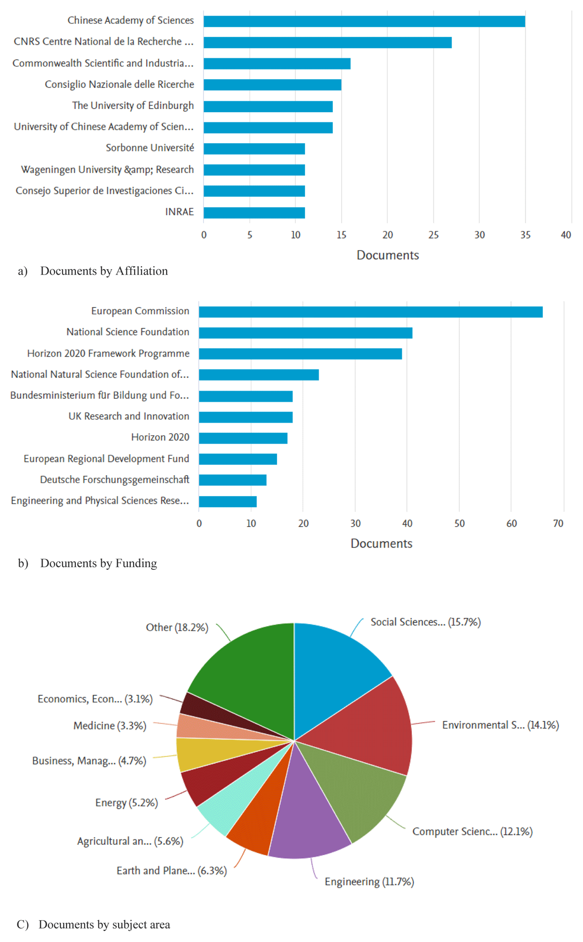
Figure 3
Contributions to OS: a) Documents by affiliation, b) Documents by funding, c) Documents by subject area.
OS and Geoinformatics are needed to drive scientific innovations and development in Africa (Okafor et al., 2022; Micheli et al., 2022). Nevertheless, several challenges should be addressed before AI-powered OS tools and platforms can be widely adopted.
These challenges include:
The need for open and FAIR data: It’s important to have access to large and well-curated datasets (Sarkar and Biswas, 2023). However, much of the data that scientists need to conduct their research is not openly accessible.
The need for ethical guidelines: It’s important to ensure that AI is used transparently and responsibly in science. Ethical guidelines for the use of AI in science are still under development.
The need for training and support: Researchers need to be trained on how to use AI-powered tools and platforms effectively. Additionally, support is needed to help researchers to identify and adopt the right AI-powered tools for their needs.
We found that these challenges are interlinked and funding may further contribute to inadequate infrastructure. However, it’s important to address the challenges associated with AI before it can be fully integrated into OS. The African governments that are considering implementing OS and Geoinformatics should:
Conduct market analysis to determine the specific needs of their research community and the existing infrastructure landscape.
Develop an implementation plan that outlines the specific activities that will be undertaken, the timeline for implementation, and the estimated costs.
Identify potential partners that can provide funding and technical support.
Monitor and evaluate the implementation process to ensure that it is on track and meeting its objectives.
By taking these steps, African governments can ensure that OS and Geoinformatics are implemented sustainably and effectively. Therefore, promoting ‘open science’ in Africa can help accelerate scientific discovery, improve research quality, and make the benefits of science more accessible to everyone. This can be approached through several steps: (a) Creating a national coordination body responsible for developing and implementing the national OS, and geospatial policy, establishing the national infrastructure, and providing training and support to researchers and policymakers. (b) Funding OS initiatives. (c) Requiring researchers to publish their work in open-access journals and make their data openly accessible. This could be done through funding and grant requirements. (d) Providing incentives for researchers to practice OS. This could include providing researchers with credit for their OS activities in performance evaluations and funding decisions. (f) Making OS and EO tools and resources available in local languages. This would make OS and Geoinformatics more accessible to African researchers and policymakers. (g) Partnering with international organizations and research institutions to promote OS and Geoinformatics.
It is anticipated that there is a growing consensus that all nations must come together on a unified platform to address the challenges associated with OS. It is essential to enact key resolutions aligned with UNESCO’s guidelines for OS and make them legally binding in member states. Although the initial steps towards implementing these resolutions may be challenging, all stakeholders must adapt to these changes to create a brighter, more transparent future for OS.
6. Conclusion
In this paper, we outlined the critical steps necessary for leveraging OS and Geoinformatics to inform policy-making and promote sustainable development in Africa. By exploring the interconnected roles of OS and Geoinformatics in advancing the SDGs as envisioned by Agenda-2063, we highlighted how sharing knowledge and resources can provide tangible solutions to societal challenges and support sustainable progress. The integration of advanced AI tools into the geospatial domain is transforming how we address societal problems, offering unprecedented opportunities for innovation and efficiency. However, without the facilitation of OS, many institutions and countries risk falling behind in adopting these new technologies. It is therefore crucial that we address the challenges associated with OS and Geoinformatics, particularly in African regions, and implement viable solutions.
To support OS and Geoinformatics effectively, it is essential to develop and implement new measures that encourage collaborative efforts across all levels. With the vast amounts of data being generated by various organizations, countries should consider establishing both official and global data-sharing portals. These platforms would enable scientists to access data quickly and easily, fostering successful partnerships and accelerating research and development.
To ensure the widespread adoption and implementation of OS and Geoinformatics, it is recommended that the OS framework and capacity-building in science are integrated into Africa’s strategies for science, technology, and innovation. By doing so, African member states can align their efforts with global best practices, ensuring that they are not only participants but also leaders of the global scientific community.
Ultimately, the journey towards a sustainable and prosperous future for Africa hinges on our collective ability to embrace OS and Geoinformatics. By fostering a culture of openness, collaboration, and innovation, we can pave the way for a brighter, more transparent future that benefits all.
Competing Interests
The authors have no competing interests to declare.
Author Contributions
Contribution of individual authors to the creation of a scientific article (ghostwriting policy).
Topic, Rania Elsayed Ibrahim; Conceptualization, Rania Elsayed Ibrahim, Tshiamo Motshegwa; Methodology, Rania Elsayed Ibrahim, Tshiamo Motshegwa, Madara Ogot, Joseph Wafula, Nokuthula P. Mchunu, Sepo Hachigonta; Software, Rania Elsayed Ibrahim; Validation, Rania Elsayed Ibrahim; Formal analysis, Rania Elsayed Ibrahim; Investigation, Rania Elsayed Ibrahim; Resources, Rania Elsayed Ibrahim, Tshiamo Motshegwa, Islam Abou El-Magd, Madara Ogot, Joseph Wafula, AZ Abotalib, Nokuthula P. Mchunu, Sepo Hachigonta, Hamed Abdelreheem Ead, John KINYURU; Data curation, Rania Elsayed Ibrahim, Tshiamo Motshegwa, Nokuthula P. Mchunu; Writing—original draft preparation, Rania Elsayed Ibrahim, Hamed Abdelreheem Ead; Writing—review and editing, Rania Elsayed Ibrahim, Hamed Abdelreheem Ead, Islam Abou El-Magd, Elham M. Ali; Project administration, Rania Elsayed Ibrahim, Islam Abou El-Magd, Tshiamo Motshegwa, Nokuthula P. Mchunu, Madara Ogot, Joseph Wafula, Sepo Hachigonta.