
Table 1
Typologies of CS engagement and their applicability to soil monitoring in conflict-affected regions.
| CS MODEL | LEVEL OF PUBLIC INVOLVEMENT | CORE FUNCTIONS | VALUE FOR ENVIRONMENTAL MONITORING | APPLICATION IN THIS STUDY |
|---|---|---|---|---|
| Contributory (selected model) | The public mostly participates in data collection using predetermined scientific guidelines. | Gathering samples on location, making simple observations, and documenting organized metadata. | Increases the geographic scope of sampling efforts and generates consistent datasets. | Soil samples are collected by local farmers and residents using a streamlined, International Organization for Standardization (ISO)-informed sampling technique. |
| Collaborative | Beyond data collection, contributors help researchers with information interpretation, cross-checking, and refinement. | Shared evaluation of the information gathered and finding any anomalies or gaps. | Enhances the validity of data and promotes mutual learning. | Members of the community assist in confirming mapped impact locations and field conditions. |
| Co-created | The research agenda, sampling strategy, and anticipated results are jointly shaped by communities and researchers. | Co-production of communication outputs, sampling zone selection, and protocol design. | Enhances relevance, builds trust, and encourages significant ownership of outcomes. | Municipalities and community representatives contributed to the development of training content and local coordination. |
| Community-Led/Extreme CS | The research process is autonomously led by local groups, which set priorities, gather data, and use the results for advocacy. | Data collection, tracking, and distribution for locally defined issues under community management. | Strengthens autonomy, fosters environmental governance, and increases long-term local capacity. | A longer-term goal is to replace contributory sampling with a community-run, locally anchored monitoring system. |
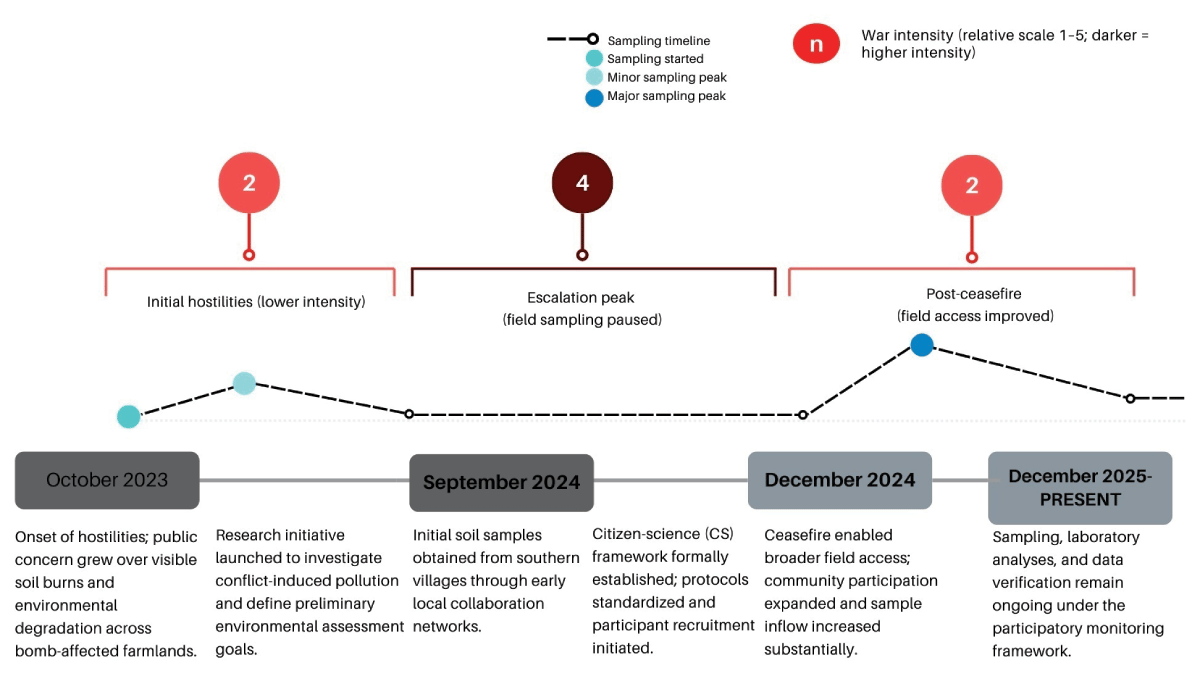
Figure 1
Timeline of conflict intensity and citizen science project activity in South Lebanon (October 2023–present). Field sampling was paused during the escalation period (September–December 2024) due to safety and access constraints, while coordination continued via local focal points. The sampling line indicates field activity status (active/paused/resumed), not sample counts.
Table 2
Flow of volunteer engagement and sample validation in the citizen science process.
| STAGE | DESCRIPTION | VOLUNTEERS/SAMPLES | OUTCOME | NOTES/OBSERVATIONS |
|---|---|---|---|---|
| Initial call for participation | Public announcement via municipal councils, university networks, and personal outreach. | ~250 interested volunteers | 100% baseline | Driven by community concern over soil safety after bombardments. |
| First training session (February 2025) | Standardized training on soil sampling, labeling, safety, and metadata recording. | ~70 volunteers (≈30% attendance) | ↓ 70% attrition | Attendance limited by mobility and security risks during conflict. |
| Sampling | Field collection by trained and peer-informed volunteers. | ~50 active samplers | ≈70% of trained volunteers | Informal peer mentoring extended training reach to untrained volunteers. |
| Peer-to-peer extension (“distributed training”) | Trained volunteers informally trained and guided neighbors who missed the formal session, expanding local coverage. | +45 additional samplers | +~90% increase in sampling reach | Demonstrates organic knowledge transfer and local ownership of the process. |
| Second training (April 2025) | Additional recruitment and expansion to new villages. | +95 new volunteers | Cumulative ≈190 contributors | Broadened geographic coverage and strengthened community inclusion. |
| Total samples | All waves combined from March–June 2025. | ~190 composite soil samples | – | Samples from 90 villagers across multiple municipalities. |
| Post-collection validation | Data filtering for completeness, coordinate accuracy, labeling consistency. | 161 validated samples from 85 verified contributors | ≈85% retention post-QC | 15% excluded due to incomplete metadata or GPS errors. |
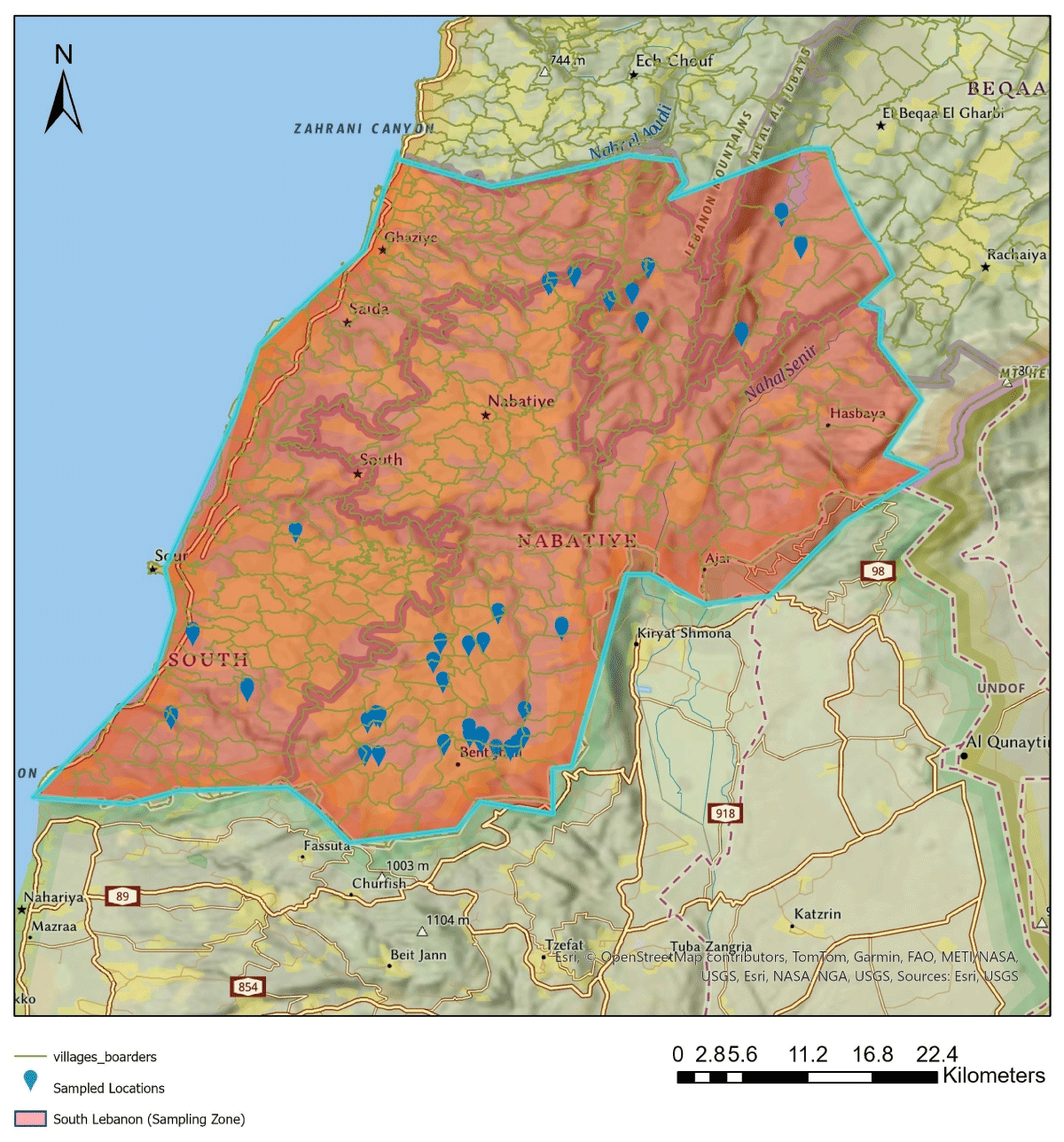
Figure 2
Spatial distribution of citizen science sampling locations across conflict-affected agricultural areas in South Lebanon between March and June 2025. Basemap: Esri, AUB GIS.
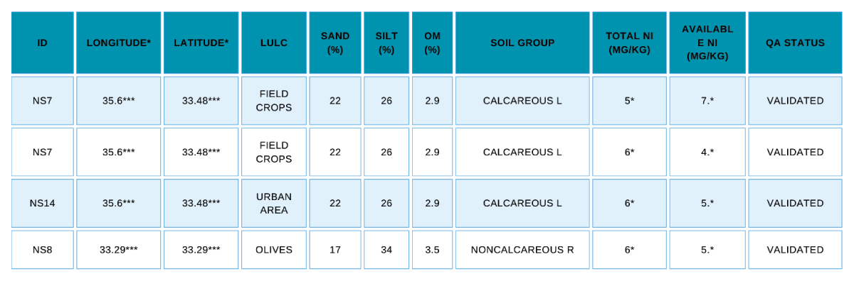
Figure 3
Example excerpt from the validated citizen science database of war-affected soils in South Lebanon. Coordinates and selected concentrations are partially masked for privacy and safety.
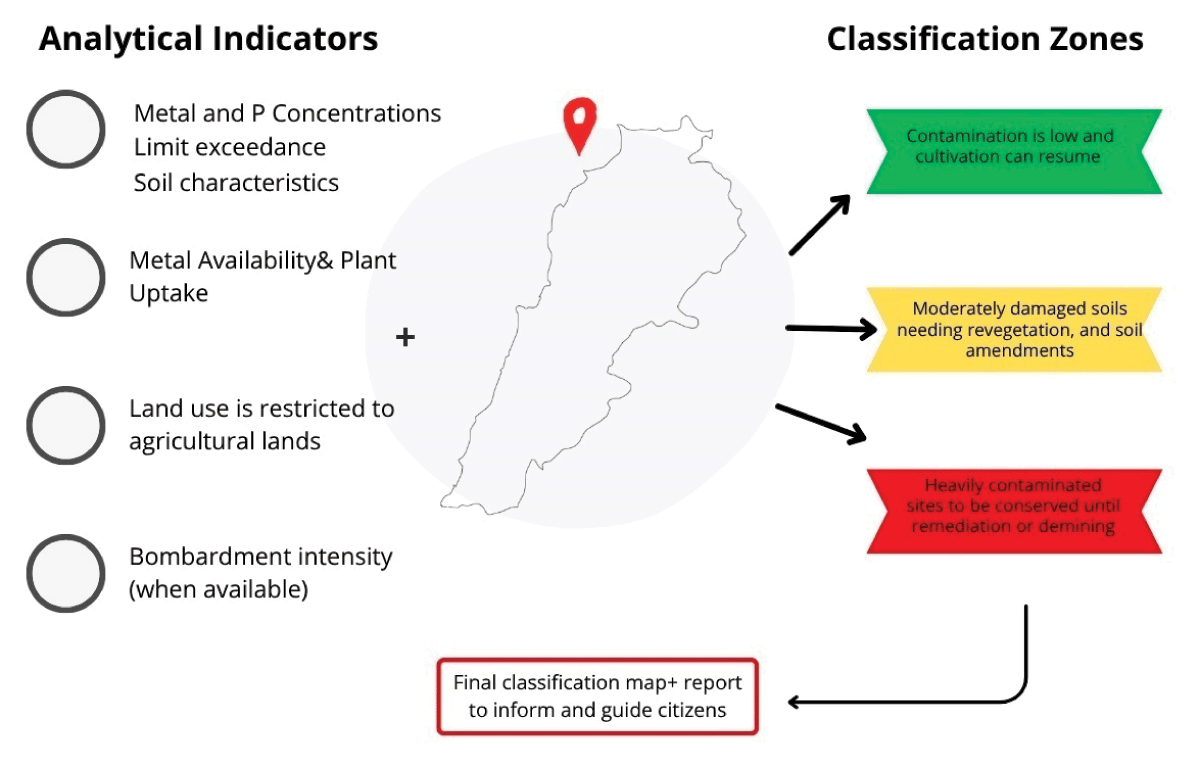
Figure 4
Conceptual and prospective zoning model showing how contamination metrics and land-use information generated through citizen sampling could be translated into provisional management categories (green, yellow, red). The figure is included as a forward-looking decision-support tool informed by the study findings, not as a finalized empirical zoning output.