
Introduction
Armed aggression, characterized by explosive and ground-altering military actions, generates numerous environmental disturbances, most notably in soil systems (Certini, Scalenghe, and Woods 2013). Shocks and disturbances brought on by armed conflict cause integrated physico-chemical-biological changes in soil systems (Pereira et al. 2022). Persistent hazardous materials, such as inorganic metals, petroleum residues, and explosive by-products, are released by explosive and thermal impacts and endure in soils and surrounding environments long after the initial event (Baliuk et al. 2022; Meaza et al. 2024). Beginning in late 2023, southern Lebanon experienced sustained bombardment with varying intensities, continuing through late 2025, including the post-ceasefire period during which the conflict remained unresolved. This war raised environmental contamination concerns in southern villages. Armed conflict is widely recognized to affect soil, water, and vegetation systems (Baliuk et al. 2022; Meaza et al. 2024); however, in many conflict-affected settings, disrupted or absent environmental assessment leaves these impacts insufficiently documented (Zwijnenburg and Postma 2017). This creates an urgent need for experimental studies to establish an accurate basis for understanding the war’s ecological footprint.
Given that land is central to livelihoods and ecological resilience (FAO and ITPS 2015; Keesstra et al. 2018), soil became a natural starting point for investigation. While conducting our review and defining the scope of post-war soil assessment, the urgent concern from locals expedited our timeline and acted as additional motivation for scientific examination. In the villages of southern Lebanon, residents showed a concern about the possible impacts of explosives on their farmland, crops, and ultimately their food chains. Fake news and the absence of formal environmental monitoring exposed them to misleading information often with exaggerated perception of pollution risk. This pattern has been observed before, where rumors tend to take an alarmist tone, thereby amplifying the perceived effects of conflict (Roy and Edwards 2019; Skarlatidou et al. 2024). From a scientific standpoint, this can undermine the credibility of environmental data and highlights the political dimensions of environmental measurement, particularly how contamination risks are interpreted, debated, and communicated in conflict settings (Van der Vet 2024).
The soil contamination status is an important starting point to detail the environmental impacts and create a scientific database. Data collection in wartime is recognized to face multiple constraints due to constant aggression, limited site access, and failure of environmental monitoring infrastructure. These factors restrict conventional field investigations in conflict settings, and even post-conflict monitoring is often further constrained by administrative and security conditions (Zwijnenburg and Postma 2017; Broomandi et al. 2020).
Researchers affiliated with the American University of Beirut (AUB) and laboratory personnel involved in environmental monitoring were unable to access the bombed zones directly due to safety and institutional restrictions, including administrative clearance requirements, security protocols, and liability regulations governing research activities in active or recently bombed areas. This limitation underscored the urgency for an alternative data collection strategy maintaining scientific rigor and field safety. Consequently, this study sought to develop and implement a practical soil sampling method under restricted war conditions, aiming to evaluate the practicality and value of using a citizen science (CS) framework as a research tool for evaluating soil quality in conflict-affected regions where conventional monitoring approaches are constrained or unfeasible.
CS broadly refers to the involvement of non-professionals in scientific research (Haklay 2013; Bonney et al. 2009). Rooted in traditions of civic science (Irwin 2002; Tolbert et al. 2025), it encompasses varying degrees of participation, from expert-led contributory projects to co-created initiatives where communities help design research and outcomes (Haklay 2013; Shirk et al. 2012). In contexts where institutional monitoring is hindered, CS provides an adaptive mechanism for producing reliable, spatially explicit data, making it particularly suited for environmental assessment in restricted or post-conflict settings (Weir, McQuillan, and Francis 2019).
In war settings, it has been described as “civilian science,” a form of participatory environmental monitoring adapted for areas affected by armed violence (Weir, McQuillan, and Francis 2019). Civilian science empowers local residents to collect, report, or help interpret environmental or health data when official monitoring is disrupted. In such contexts, the goal is to generate fit-for-purpose evidence that can identify contamination hotspots, document environmental harm, and support accountability when conventional monitoring is not feasible. Here, “just-good-enough” evidence refers to timely, spatially indicative, community-generated data rather than comprehensive regulatory assessment (Gabrys et al. 2016). Thus, this merges the rigor of CS with the exigencies of conflict contexts, serving as a methodological framework and an instrument for environmental restoration, while filling the gap of missing scientific damage assessments. Under conditions of war, CS is not only a practical adaptation but also an ethical and epistemic challenge. Involving local residents in environmental monitoring raises questions about risk, responsibility, and how knowledge is produced under insecurity. While participation can extend monitoring and support locally grounded evidence, it may also place uneven burdens on affected communities. We therefore approach civilian science as a situated form of knowledge production shaped by vulnerability, care, and uneven authority.
This study examines whether a CS framework can generate reliable, spatially explicit evidence of soil contamination under the institutional and mobility constraints imposed by conflict in South Lebanon. Specifically, it evaluates whether citizen-led sampling can support the identification of contamination patterns in accessible locations when conventional monitoring is not feasible. The contribution of the study is therefore bounded: Rather than providing a fully representative assessment across all affected areas, it demonstrates that, under defined conditions of training, protocol standardization, and laboratory validation, citizen-collected samples can produce methodologically adequate evidence within the sampled sites. The evidentiary scope of the study is bounded by its sampling design and the specific conditions where data were generated. Accordingly, the study frames CS not as a comprehensive substitute for formal monitoring, but as a constrained yet operational approach for generating fit-for-purpose environmental evidence in conflict-affected settings. The article first situates the study within CS and civilian science debates, then describes the adapted participatory sampling framework developed for wartime conditions, and finally assesses what this approach demonstrates about the feasibility and limits of citizen-led environmental monitoring in conflict-affected landscapes.
Methodology
The methodology we adopted entailed a two-phase research plan combining a literature and an applied component: (i) The first phase consisted of a literature review that informed the study’s conceptual framework and methodological design. (ii) The second phase put these insights into practice by developing and implementing a CS–based soil sampling campaign tailored to war-related constraints in southern Lebanon.
Review
An extensive literature review on the methods and applications of CS was conducted during the first phase. We concentrated on the fundamentals of CS, typological differences, operational phases, and significant innovations in the environmental studies field, particularly in the area of soil assessment. This review directly informed the methodological design of the study by guiding the selection of an appropriate participatory model, the development of simplified sampling and training protocols, and the incorporation of validation procedures suited to conflict-affected settings. This investigation also extended participatory inquiry into vulnerable and conflict-impacted environments where formal monitoring systems are weak or nonexistent, taking into account the changing paradigm of civilian science (Weir, McQuillan, and Francis 2019).
The study drew on foundational frameworks that describe how science and society co-produce knowledge, including participatory environmental monitoring (Danielsen et al. 2009) and the CS project life cycle (Fraisl et al. 2022). These frameworks informed the application of CS in war-affected settings by emphasizing practices beyond procedural compliance: strategic volunteer recruitment attentive to local diversity and lived experience, continuous context-responsive training, transparent data verification, and accessible results sharing. Particular attention was given to CS under constrained conditions, including high-risk, data-poor, and contaminated environments where limited mobility and weak governance make conventional monitoring difficult (Simmons et al. 2022). These concern how CS redistributes responsibility, authority, and knowledge production. Participation may broaden who contributes data, but it does not automatically equalize who defines protocols, validates evidence, or interprets results (Shirk et al. 2012). This is especially important in sensitive settings (Weir et al. 2019), where trust and legitimacy are unevenly structured (Skarlatidou et al. 2024).
CS reoriented environmental monitoring by broadening how data and expertise are co-produced across disciplines, including hydrology (Buytaert et al. 2014; Baalbaki et al. 2019), biodiversity (Theobald et al. 2015; Pocock et al. 2018), and soil systems (Mason et al. 2024; Charvát et al. 2025). By expanding the geographic, temporal and participatory scope of environmental observations, CS generates knowledge systems beyond the operational and financial reach of traditional monitoring. It transforms disparate local observations into coherent datasets that depict ecological change over time.
CS has both scientific and social value in environmental research. Beyond contributing data, citizen engagement can foster environmental literacy by helping contributors better understand ecosystem processes and their own role within them. It has therefore been described not only as a scientific method, but also as an educational and political practice that can strengthen accountability, local stewardship, and community capacity to recognize and respond to conflict-related environmental change (Danielsen et al. 2009; Austen et al. 2024). In soil research, public participation has been shown to deepen understanding of soil’s ecological and cultural significance and, when supported by clear protocols, to generate valid data on contamination and related processes (Pino et al. 2022; Ureta et al. 2022; Keuskamp et al. 2013). Participatory sampling has also been used to assess trace-metal contamination with sufficient accuracy for formal risk assessment and to make complex contamination data more understandable and locally meaningful (Taylor et al. 2021; Jiao et al. 2016).
At the same time, participatory environmental monitoring faces persistent challenges of data quality, standardization, and inclusion (Pocock et al. 2017). These can be reduced through community-adapted quality assurance, including simplified protocols, context-sensitive training, standardized metadata, and iterative validation (Baker et al. 2021; Balázs et al. 2021). Such measures do not remove uncertainty but help keep citizen-generated data reliable and fit for purpose under operational constraints, consistent with guidance on non-expert monitoring (USEPA 2019). In this study, they included simplified but standardized soil-sampling instructions; structured metadata recording; laboratory screening; and stepwise checks of labels, coordinates, field notes, and pre-analytical acceptance criteria. CS is also not inherently inclusive or empowering: Participatory processes may still reproduce social inequalities under uneven conditions of trust, access, and authority, especially in conflict-affected settings (Pateman et al. 2021; Herzog and Lepenies 2022; Mayes 2022; Weir et al. 2019). This is particularly relevant in post-conflict Lebanon, where weakened soil-monitoring systems make CS valuable not only as an alternative means of data collection, but also as a framework for rebuilding environmental knowledge and public stewardship. Sustained engagement, however, depends on local relevance, learning opportunities, and visible outcomes, especially when volunteers receive feedback on their contributions (Finger et al. 2023; Skarlatidou et al. 2024; Davis et al. 2020; Bedessem et al. 2023; Lopez 2021; Tiago et al. 2017).
Research increasingly shows that CS helps address monitoring gaps in fragile settings. The related concept of civilian science emphasizes participatory data collection by local observers and NGOs where institutional access is restricted or unsafe (Weir et al. 2019). In such contexts, informal networks can become important environmental intelligence sources, while remote sensing is most effective when paired with grounded observation (Zwijnenburg and Postma 2017; Sticher et al. 2023; Zwijnenburg and Ballinger 2023). In Lebanon, ongoing hostilities, restricted airspace, and politicized data make community-based ground monitoring one of the most practical and ethically appropriate ways to document soil contamination and environmental change.
CS spans different levels of participation, from contributing observations or samples to involvement in data collection, evaluation, and analysis (Shirk et al. 2012; Haklay 2013). These models vary in public involvement, co-design, and decision-making authority. Table 1 summarizes the main typologies and their relevance to post-conflict soil monitoring.
Table 1
Typologies of CS engagement and their applicability to soil monitoring in conflict-affected regions.
| CS MODEL | LEVEL OF PUBLIC INVOLVEMENT | CORE FUNCTIONS | VALUE FOR ENVIRONMENTAL MONITORING | APPLICATION IN THIS STUDY |
|---|---|---|---|---|
| Contributory (selected model) | The public mostly participates in data collection using predetermined scientific guidelines. | Gathering samples on location, making simple observations, and documenting organized metadata. | Increases the geographic scope of sampling efforts and generates consistent datasets. | Soil samples are collected by local farmers and residents using a streamlined, International Organization for Standardization (ISO)-informed sampling technique. |
| Collaborative | Beyond data collection, contributors help researchers with information interpretation, cross-checking, and refinement. | Shared evaluation of the information gathered and finding any anomalies or gaps. | Enhances the validity of data and promotes mutual learning. | Members of the community assist in confirming mapped impact locations and field conditions. |
| Co-created | The research agenda, sampling strategy, and anticipated results are jointly shaped by communities and researchers. | Co-production of communication outputs, sampling zone selection, and protocol design. | Enhances relevance, builds trust, and encourages significant ownership of outcomes. | Municipalities and community representatives contributed to the development of training content and local coordination. |
| Community-Led/Extreme CS | The research process is autonomously led by local groups, which set priorities, gather data, and use the results for advocacy. | Data collection, tracking, and distribution for locally defined issues under community management. | Strengthens autonomy, fosters environmental governance, and increases long-term local capacity. | A longer-term goal is to replace contributory sampling with a community-run, locally anchored monitoring system. |
Based on methodological guidance and conflict-related constraints, this study adopted a mainly contributory CS model centered on standardized soil sampling by trained volunteers. Limited collaborative elements were retained where local contextual knowledge was essential for confirming impact locations, site accessibility, and field conditions, providing a practical balance between scientific rigor and community engagement where insecurity, incomplete maps, limited mobility, and limited resources made deeper co-design impractical (Senabre Hidalgo et al. 2021; Vasiliades et al. 2021).
This model enabled standardized, traceable data collection through streamlined ISO-adapted procedures and locally relevant training without compromising contributor safety. Volunteers contributed essential local judgment, while protocol design, validation, and interpretation remained with the research team. To fit Lebanon’s wartime context, protocols were simplified and translated into Arabic, standard equipment was replaced with low-cost local tools, and coordination relied on trusted focal points. These adaptations informed the pilot strategy implemented through mobilization, training, sampling design, and fieldwork.
Action work and field implementation
The second phase moved from conceptual design to field implementation. Although the civilian-science framework was developed in 2024 in response to restricted institutional access and escalating bombardment in southern Lebanon, most fieldwork took place between January and June 2025. This article evaluates the feasibility, procedural robustness, and data-integrity mechanisms of that implementation under conflict-related constraints.
The framework was adapted to the operational and ethical realities of Lebanon’s conflict-affected landscapes, drawing selectively on participatory environmental monitoring approaches (Danielsen et al. 2009; Pino et al. 2022). It prioritized contributor safety, procedural transparency, and adaptive inclusivity as core elements of reliable environmental research. A call for volunteers was shared through the Lebanese Association of the Knights of Malta, also known as Order of Malta Lebanon (OML) in war-affected southern villages to support soil sampling and site documentation in safe, accessible locations (Supplemental File 1: Figure S1). Rather than relying mainly on digital platforms, recruitment used trusted relational networks, including municipalities, university contacts, and personal ties, which were effective under conditions of insecurity. Field communication and coordination were mediated through OML, represented by Adel Ghandour, who served as the primary liaison between the research team and village-level contributors. The research team provided the scientific sampling protocol, training instructions, safety precautions, and sample-handling requirements, while OML coordinated outreach, communication, practical training, and field implementation with farmers, municipal contacts, and village contributors. To support standardized participation, we developed a bilingual illustrated guide and a soil-sampling plan informed by Ivan et al. (2025), based on concentric distances from visible impact points (0, 10, 30, and 50 m, with a distant control at ~300 m where feasible), adjusted for land use, slope, and accessibility (Supplemental File 2: Figure S2). Visible impact indicators included craters, burned patches, or other bombardment-related features located within or near land contributors could safely and routinely access. Thus, “0 m” referred to the nearest accessible soil point associated with a visible impact feature, not entry into an unsafe crater, bombed structure, or restricted zone. Volunteers collected soil from 0–15 cm depth using clean hand tools, usually from their own fields, orchards, or gardens.
Approximately 500 g of soil was collected at each point, placed in labeled plastic bags, and accompanied by metadata on land use, crop type, visible residues, and GPS coordinates recorded by smartphone.
Peer assistance was provided where needed through a train-the-trainer model, which extended participation while enabling peer-to-peer skill transfer and distributed quality control without continuous external supervision (Lorke et al. 2019; Weinstein et al. 2025; Russell et al. 2024). Participation was voluntary and unpaid; sampling materials and laboratory analyses were covered through institutional research funding, and training used a hybrid format with printed, digital, and in-person support where feasible (ISO 2017).
Samples were labeled with unique identifiers and field notes, then tracked through a streamlined chain-of-custody procedure to maintain traceability (Corbau et al. 2025). Before analysis, they were air-dried, sieved (<2 mm), and homogenized. Total metals (Pb, Cd, Ni, Cu, Zn) were measured by acid digestion (EPA 3051A) and Atomic Absorption Spectrophotometry (Thermo Scientific iCE 3000), while total and reactive phosphorus were determined by acid extraction and colorimetry (ISO 6878). Quality control included blanks, certified reference materials, and duplicate analysis of 10% of samples. Contributor safety was prioritized as a methodological constraint rather than only as an ethical principle. Potential risks included damaged terrain, metallic fragments, renewed military activity, psychological stress, and security concerns linked to location documentation. To reduce these risks, contributors were instructed to sample only from familiar, regularly accessed land and to avoid bombed structures, craters, fenced or military-marked areas, and unfamiliar sites. They were also instructed not to touch metallic fragments or suspicious objects, to sample during daylight, and to stop immediately if safety concerns arose. This safety-first approach took priority over spatial completeness: Contributors were not asked to travel beyond familiar safe zones to obtain additional samples or reach presumed hotspots, and some potentially relevant areas were therefore deliberately excluded. No contributor injury or direct adverse event was reported to the research team; sampling was paused or delayed during periods of renewed conflict intensity or restricted land access. The project followed a precautionary, care-based approach: contributors could decline, stop, or withdraw their contribution before analysis or reporting, and voluntary participation was confirmed verbally or in writing depending on field conditions, contributor preference, and access to the participation-confirmation form. When Adel could reach farmers directly, the written form was completed on the spot; otherwise, including during peer-to-peer participation, mobility restrictions, limited form access, or time-sensitive sampling, the same information was explained verbally before any contribution was accepted. Verbal confirmation consisted of oral agreement after explaining the project purpose, sampling procedure, potential risks, safety instructions, and withdrawal option. Supplemental File 3: Appendix A includes the participation-confirmation template, with fields for verbal confirmation, witness name/role, and the reason written confirmation was not used. All contributors received the same core information; only the mode of documentation differed.
The AUB Human Research Protection Program/Institutional Review Board (HRPP/IRB) reviewed the activities as described and provided written clarification that the project does not fall under the definition of Human Subject Research and does not require IRB review. This determination was based on the project as conducted: The activity focused on environmental soil sampling and site documentation, and the visible site observations and photographs did not capture human subjects. The AUB HRPP/IRB Manual, Version 8, February 2020, defines a human subject as a living individual “about whom” investigators obtain data through intervention or interaction, or identifiable private information.
In this study, the object of inquiry was soil/site condition, not contributors as persons. Field-facing communication, training, and soil sampling were coordinated by Order of Malta Lebanon (OML), while the AUB research team provided the sampling methodology, safety and training guidance, sample-handling instructions, and laboratory analysis. Optional contact details, where provided to local mediators for coordination or clarification, were not incorporated into the analytical dataset or reported in the manuscript. Sensitive geolocation data were anonymized, generalized, or aggregated in outputs. The HRPP/IRB clarification applies only to the activities described and is therefore context-specific, not a general determination for CS studies. Safeguards consistent with participatory environmental research were nevertheless applied, including transparency, voluntary participation, risk minimization, withdrawal options, responsible data handling, and cautious communication in a conflict-affected setting. Appendix A provides the participation-confirmation template used to document voluntariness, risk disclosure, withdrawal options, and soil data-use permissions.
Results and Discussion
Implementation and volunteer participation
The CS framework was developed in 2024 in response to escalating bombardment in southern Lebanon to support community-based soil sampling in conflict-affected areas. Recruitment increased after the ceasefire, when mobility improved, then stabilized, with participation closely tracking the rhythm of the conflict: It declined during renewed airstrikes but recovered quickly through trusted local networks. Figure 1 shows the temporal alignment between major bombing events and citizen-sampling activity, with fieldwork concentrated during brief ceasefires. A total of 85 volunteers contributed to the study, the majority of whom were municipal employees, farmers, and students. To maintain soil sampling across the study area, core volunteers, those trained directly by the research team or through peer-based instruction, were essential. This supports the value of the train-the-trainer model described by Lörke et al. (2019), and aligns with broader evidence that peer learning and local facilitation can sustain participatory environmental monitoring where institutional presence is limited (Benyei et al. 2023).
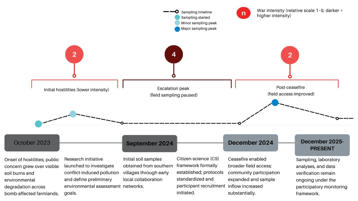
Figure 1
Timeline of conflict intensity and citizen science project activity in South Lebanon (October 2023–present). Field sampling was paused during the escalation period (September–December 2024) due to safety and access constraints, while coordination continued via local focal points. The sampling line indicates field activity status (active/paused/resumed), not sample counts.
After the initial training session in February 2025, contributors were introduced to standardized procedures for soil collection, labeling, and risk management. Attendance was limited to about 30% because of mobility constraints and psychological reluctance under ongoing conflict. A second training and coordination meeting in April 2025 expanded coverage to additional villages. Across these engagement waves, 90 villagers from multiple municipalities collected 200 composite soil samples. After screening for completeness, coordinate accuracy, and labeling consistency, 161 validated samples from 85 contributors were retained. Table 2 summarizes how participation evolved in relation to access, motivation, and assurance. Despite the crisis, volunteers maintained strong procedural consistency, with only minor variation in GPS accuracy and labeling; about 15% of records were excluded during metadata screening.
Table 2
Flow of volunteer engagement and sample validation in the citizen science process.
| STAGE | DESCRIPTION | VOLUNTEERS/SAMPLES | OUTCOME | NOTES/OBSERVATIONS |
|---|---|---|---|---|
| Initial call for participation | Public announcement via municipal councils, university networks, and personal outreach. | ~250 interested volunteers | 100% baseline | Driven by community concern over soil safety after bombardments. |
| First training session (February 2025) | Standardized training on soil sampling, labeling, safety, and metadata recording. | ~70 volunteers (≈30% attendance) | ↓ 70% attrition | Attendance limited by mobility and security risks during conflict. |
| Sampling | Field collection by trained and peer-informed volunteers. | ~50 active samplers | ≈70% of trained volunteers | Informal peer mentoring extended training reach to untrained volunteers. |
| Peer-to-peer extension (“distributed training”) | Trained volunteers informally trained and guided neighbors who missed the formal session, expanding local coverage. | +45 additional samplers | +~90% increase in sampling reach | Demonstrates organic knowledge transfer and local ownership of the process. |
| Second training (April 2025) | Additional recruitment and expansion to new villages. | +95 new volunteers | Cumulative ≈190 contributors | Broadened geographic coverage and strengthened community inclusion. |
| Total samples | All waves combined from March–June 2025. | ~190 composite soil samples | – | Samples from 90 villagers across multiple municipalities. |
| Post-collection validation | Data filtering for completeness, coordinate accuracy, labeling consistency. | 161 validated samples from 85 verified contributors | ≈85% retention post-QC | 15% excluded due to incomplete metadata or GPS errors. |
Sampling coverage, analytical progress, and data integrity
The CS network gathered 161 validated soil samples from 29 bomb-affected villages. Although field accessibility and land size limitations prevented the full design from being implemented at every site, coverage within 0–200 m of impact craters remained consistent with actual exposure zones. Figure 2 shows the spatial distribution of CS sampling locations relative to confirmed bombing coordinates. The map illustrates the initiative’s scope, demonstrating that citizen-led sampling covered a sizable portion of the southern agricultural belt. During the post-war recovery phase, collective local action filled critical monitoring gaps, as evidenced by each marked point that represents both a scientific data entry and a moment of civic engagement. Beyond its geographical range, the dataset is Lebanon’s first coordinated, georeferenced record of war-affected soils produced through public involvement. The accuracy and completeness of recorded coordinates and metadata suggest that volunteers generally followed standardized field instructions, supporting the adequacy of the training model under constrained conditions. The validated dataset consists of a structured spreadsheet and GIS-linked file containing sample ID, village/area, land-use classification, GPS coordinates (Soil_X/Soil_Y), soil type, and laboratory results (total metals and phosphorus fractions). Each record is traceable through a unique alphanumeric identifier linked to metadata and chain-of-custody documentation. An illustrative excerpt of the database structure is presented in Figure 3 to clarify the organization of the validated dataset.
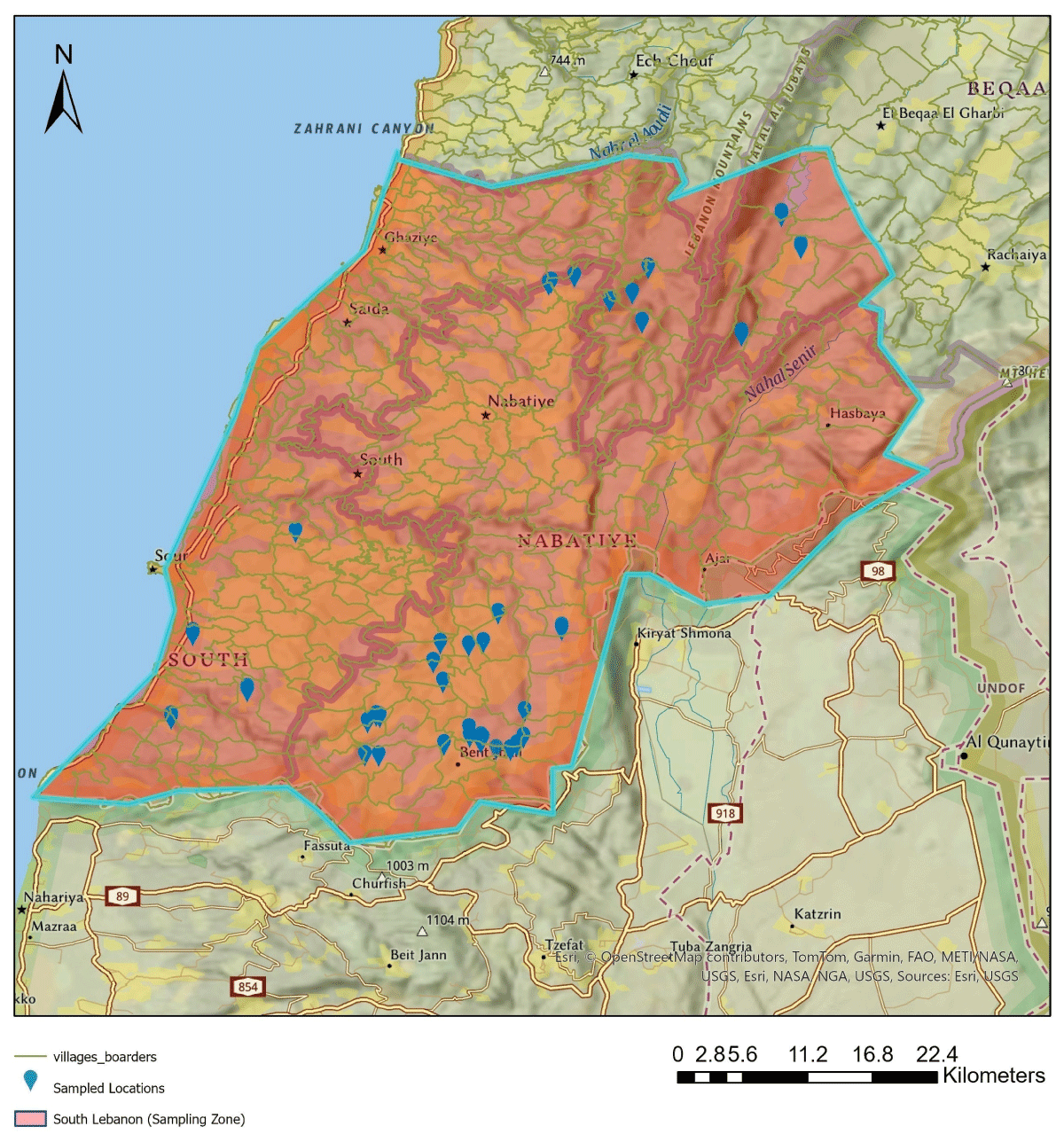
Figure 2
Spatial distribution of citizen science sampling locations across conflict-affected agricultural areas in South Lebanon between March and June 2025. Basemap: Esri, AUB GIS.
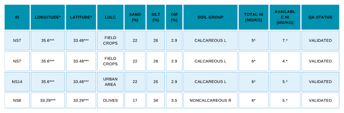
Figure 3
Example excerpt from the validated citizen science database of war-affected soils in South Lebanon. Coordinates and selected concentrations are partially masked for privacy and safety.
To support data reliability under conflict-related constraints, quality assurance was implemented as a sequential process spanning upstream design, midstream screening, and downstream validation. Upstream measures included standardized protocols, pilot testing, controlled vocabularies, geolocation checks, and structured field records to reduce field and metadata errors at source (Balázs et al. 2021). Midstream controls involved pre-analytical screening of submitted samples for physical integrity, sample adequacy, chain-of-custody documentation, labeling consistency, sampling-depth compliance, and metadata completeness. Records that failed these criteria were excluded from the validated dataset. Downstream validation combined plausibility screening, peer and expert review, iterative correction, and laboratory quality assurance and quality control (QA/QC).
Laboratory analyses used standardized digestion and extraction procedures, with internal quality control including method blanks, continuing calibration verification (CCV), and routine instrument performance checks. Laboratory analyses of total metals and phosphorus fractions provided analytical verification that accepted citizen-collected samples were methodologically adequate for identifying contamination patterns under constrained field conditions. Together, these measures formed an integrated QA framework, summarized in Supplemental File 4: Figure S3 and detailed in Supplemental File 5: Appendix B, supporting the reliability of the modified CS approach as a tool for environmental monitoring (Monitora et al. 2023).
Taken together, the results demonstrate four main outcomes: the establishment of a conflict-time sampling network across 29 bomb-affected villages; the generation of a validated dataset of 161 georeferenced soil samples from 85 contributors; evidence that trained and peer-supported volunteers could follow standardized protocols with acceptable data quality under wartime constraints; and a participatory process through which local concern over soil safety was translated into documented environmental evidence.
Community engagement and knowledge return
This project aimed at restoring trust, agency, and environmental awareness in communities that were impacted by conflict by means of participation, knowledge return, and communication. Although these aspects were not quantitatively measured, they may have been supported through sustained participation of volunteers, repeated sampling, peer-to-peer engagement, as well as sustained communication with coordinators. Updates were communicated to volunteers through municipal focal points and repeated engagement with coordinators, as part of a transparency-oriented approach intended to reduce the risk of extractive research practices. A comprehensive restoration plan will be needed after the conflict, but the continued cultivation of bomb-affected soils also makes targeted interim rehabilitation measures necessary (Baliuk et al. 2022). In a later post-war phase, the project aims to expand sampling across impacted areas of South Lebanon to support a spatial zoning framework for restoration planning, drawing on approaches used in other war-affected settings (de Matos-Machado et al. 2019; Bonchkovskyi et al. 2025). The zoning model presented here is conceptual and prospective. It illustrates how contamination metrics generated through citizen sampling could be translated into land-management categories; it does not represent a finalized spatial zoning output derived from the complete dataset.
Under this proposed framework, soils would be categorized as green, yellow, or red zones.
Green zones: low contamination; cultivation can resume following basic agrochemical testing and organic or mineral amendment.
Yellow zones: moderately impacted soils requiring crater filling, re-vegetation, and targeted amendment.
Red zones: heavily bombed or phosphorus-contaminated areas that should remain under conservation until remediation or demining is completed.
The intention of this framework is to provide a structured basis for communicating results to local stakeholders and to support future integration of soil restoration priorities with environmental and public health safeguards once broader recovery planning becomes feasible.
Figure 4 presents a color-coded zoning framework that integrates land use, soil geochemistry, and contamination data to communicate management priorities. By translating analytical results into accessible visual guidance, it can support shared decision-making by citizens and local authorities during restoration. Early low-cost measures, such as organic matter addition and slope stabilization, may help limit erosion and contaminant spread before full remediation begins. At the policy level, findings can be synthesized into technical reports and briefs aligned with municipal and ministerial needs, strengthening the science-policy-society interface and linking community-generated evidence to both immediate soil safety actions and longer-term recovery planning (Meaza et al. 2024).
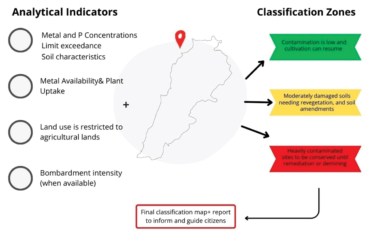
Figure 4
Conceptual and prospective zoning model showing how contamination metrics and land-use information generated through citizen sampling could be translated into provisional management categories (green, yellow, red). The figure is included as a forward-looking decision-support tool informed by the study findings, not as a finalized empirical zoning output.
Challenges and lessons learned
Implementing CS during war involved major structural, operational, and methodological challenges. Field coordination and sample delivery were disrupted by restricted access, safety concerns, and communication breakdowns. Active bombardment, distress, and institutional mistrust also reduced participation, while some volunteers required reassurance about confidentiality. As noted in related work, war-related trauma, insecurity, and weak civic and epistemic trust can limit engagement in scientific initiatives (Weir et al. 2019; Skarlatidou et al. 2024; Karam et al. 2025). Methodological constraints included unavoidable spatial bias, the exclusion of inaccessible or UXO-contaminated zones, and likely underrepresentation of peak contamination in border areas. Equipment variability, signal interference, and satellite distortion produced minor metadata inconsistencies and GPS deviations during the conflict. Access and airspace insecurity also prevented cross-validation of citizen-generated data with expert or remote-sensing references, although such comparison is known to improve participatory monitoring accuracy and confidence (Baker et al. 2021; Loglisci et al. 2024; Ziliaskopoulos and Laspidou 2024). Participation was also uneven, tending to concentrate among better-resourced or better-connected households, consistent with inclusivity challenges reported in other CS projects (Hecker et al. 2018; Jönsson et al. 2024). This likely shaped the knowledge produced by amplifying better-connected sites and concerns while underrepresenting more isolated or marginalized areas, showing how wartime environmental knowledge is conditioned by uneven exposure, unequal participation, and negotiated trust.
These findings should therefore be read as evidence of feasibility and fit-for-purpose adequacy, not as a comprehensive account of contamination across all affected areas. In this case, CS was sufficient to document contamination patterns in sampled locations and to show that wartime civilian science can generate usable environmental evidence, but not to support broader claims of full representativeness beyond the sampled context.
A recurring limitation was the lack of consistent institutional and financial support, which constrained training and the development of longer-term data systems. Resource and compensation support are recognized as important for sustaining participation, particularly in crisis-affected settings where local capacities and livelihoods are under strain (Benyei et al. 2023). Even modest logistical or financial support could strengthen local action, reinforce community capacity, and make participation more equitable and sustainable.
Overall, the project shows how social cohesion and scientific rigor are intertwined in research impacted by conflict, when trusted local networks, clear protocols, and validation procedures are in place, despite ongoing constraints related to access, security, and institutional capacity. Future efforts should pair community-based sampling with institutional partnerships, secure digital tools for real-time validation and feedback, and use remote-sensing data to cross-check field observations. Embedding such participatory approaches in national monitoring programs could strengthen both data reliability and post-conflict environmental governance.
Conclusion
In addition to upsetting ecosystems, the ongoing conflict in South Lebanon sparked a strong scientific and civic duty to record its effects on the environment under constrained conditions. This study shows that a CS approach, tailored to local realities, can serve as a civilian science framework in conflict-affected areas despite limited access and safety risks. The findings demonstrate the feasibility of community-based soil sampling and the methodological adequacy of the approach for producing spatially explicit contamination data in sampled locations. At the same time, the evidence should be interpreted within the limits of the study design, which was shaped by uneven participation, restricted access, and the practical conditions of wartime data collection. The project also suggests that participatory environmental monitoring may help connect scientific assessment with local concerns around land recovery, remediation, and cultivation. Rather than offering a comprehensive or universally replicable model, this work provides a context-specific example of how CS can generate fit-for-purpose environmental evidence in a conflict-affected setting.
Supplementary Files
The Supplementary files for this article can be found as follows:
Supplemental File 1
Figure S1. Citizen science participation announcement. DOI: https://doi.org/10.5334/cstp.956.s1
Supplemental File 2
Figure S2. Soil-sampling plan, required field tools, and safety measures. DOI: https://doi.org/10.5334/cstp.956.s2
Supplemental File 3
Appendix A. Participation-confirmation template. DOI: https://doi.org/10.5334/cstp.956.s3
Supplemental File 4
Figure S3. Citizen science workflow and quality-assurance process. DOI: https://doi.org/10.5334/cstp.956.s4
Supplemental File 5
Appendix B. Quality-assurance and validation procedures. DOI: https://doi.org/10.5334/cstp.956.s5
Ethics and Consent
The American University of Beirut Human Research Protection Program/Institutional Review Board (AUB HRPP/IRB) determined that the study did not constitute human-subject research and did not require IRB review. In written correspondence dated 10 September 2026, the IRB officially confirmed that “the protocol submitted does not fall under ‘Human Subject Research’ definition and does not require IRB review.” The HRPP/IRB was aware of the journal submission and requested the submitted manuscript as part of the determination process. The study concerned environmental soil sampling and site documentation rather than research on contributors as individuals. Relevant institutional definitions and guidance are provided in the AUB HRPP/IRB Manual (American University of Beirut, 2020).
Citizen scientists participated voluntarily and without remuneration, providing verbal or written consent after receiving information on the project, sampling activities, risks, safety measures, and withdrawal options. Potential risks included damaged terrain, suspicious objects, renewed military activity, psychological stress, and disclosure of sensitive locations. Sampling was restricted to familiar, safe, accessible land, with instructions to avoid hazardous areas and objects and stop if safety concerns arose. Fieldwork was paused or delayed during heightened insecurity, and sensitive location data were protected in research outputs. No contributor injury or direct adverse event was reported. Further details are provided in the Methodology section and Appendix A.
Acknowledgements
The authors extend their sincere gratitude to the citizens of the villages across South Lebanon, whose collaboration made this study possible. We would especially like to express our gratitude to all of the farmers and members of the community who generously donated their time, expertise, and trust during the difficult post-conflict circumstances by taking part in the soil sampling process. At the core of this work is their dedication to preserving their land and restoring their environment.
Data Accessibility Statement
The dataset underlying this study is not currently publicly available because data curation and analysis are still in progress and because it includes sensitive location-based environmental information from a conflict-affected area. Public release at this stage, without full contextualization, may risk misinterpretation and raise ethical and security concerns for participating communities and sampled sites. Aggregated data and selected de-identified materials may be made available by the corresponding author upon reasonable request, subject to review of the intended use and relevant ethical considerations.
Author Contributions
Leen Dirani coordinated the study and drafted the manuscript. Rami Zurayk contributed to conceptualization, project administration, visualization, and manuscript review and editing. Adel Ghandour liaised with farmers and delivered soil samples. Nermine Faaour conducted laboratory work and supported coordination. Reem Jaber assisted with laboratory work and coordination.