
1. INTRODUCTION
Post-disaster reconstruction is not only technical or institutional but also a knowledge practice: a socially embedded process through which claims about risk, priorities and legitimate authority are assembled, contested and stabilised (Jabareen 2013; Arefian 2018; Sakalasuriya et al. 2018). Here, knowledge practice refers to observable documentary and institutional operations through which actors produce, contest and stabilise what counts as actionable knowledge in reconstruction. These practices include legal interpretation, committee deliberation and standard-setting (e.g. route valuation procedures). They also include inscription work—producing and circulating plans, maps and reports—and recording disputes in Diet minutes and other proceedings. Throughout, three related terms are used in a specific way.
First, rather than invoking a loose ‘epistemic enterprise’, reconstruction is treated as knowledge ordering: legal tools, valuation methods, and planning categories are assembled and ranked so that some ways of seeing the city become actionable, while others are marginalised. ‘Knowledge ordering under constraint’ highlights how these classificatory and procedural decisions were made under severe time pressure, material scarcity and overlapping jurisdictions, e.g. when officials prioritised particular streets, risks and neighbourhoods because they could not address all claims at once. Finally, ‘institutional memory’ is used to describe how prior experiences and records of disaster and planning—such as the 1923 Great Kantō Earthquake, pre-war city planning designations, and earlier fires and floods in Fukui—were recalled, archived, and translated into post-war standards and design choices through the careers and writings of specific actors. These terms allow the tracing of how competing understandings were translated into enforceable decisions under severe constraint.
Fukui city’s reconstruction after two successive disasters—the United States Army Air Forces (USAAF) air raid of 19 July 1945 and the inland earthquake of 28 June 1948 (Figure 1)—is examined as a historically situated case of reconstruction-as-knowledge practice. Rather than viewing these two events as discrete moments of destruction and response, this article treats the overlapping post-war and post-seismic recoveries as a single, compounded project of reconstruction-as-knowledge practice, in which planning laws, engineering standards and war memories were actively reworked. Central to this process was the mobilisation and negotiation of knowledge across diverse registers: planning laws and engineering standards; war memory and imperial trauma; emergent democratic ideals; and localised technical know-how. The case of Fukui shows that post-disaster reconstruction does not merely restore a damaged urban fabric: it reorders institutional priorities, political authority and spatial epistemologies under pressure.
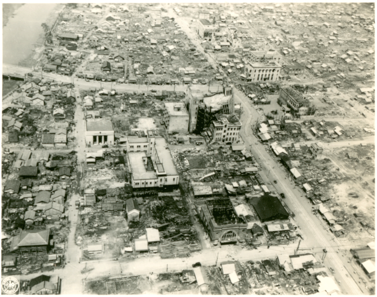
Figure 1
The vast devastation one month after the earthquake of 28 June 1948: at centre is the Fukui Bank building, nearby the ruins of the Daiwa Store Department and at left the approach to and start of Saiwai Bridge.
Source: Courtesy of the Theodore Akimoto Family Collection.
Fukui’s case foregrounds four interrelated themes—knowledge politics, temporal compression, symbolic urbanism and multiscalar governance—as empirical registers for tracing planning choices and institutional negotiations (1945–55). First, knowledge politics in post-war Fukui was defined by intense negotiation between national policies, occupation-era reforms and local governance strategies. Mayor Kumagai Tasaburō1 was an important actor in this process, but this article focuses on the documentary and institutional mechanisms through which priorities were negotiated and stabilised across levels of government (Takahashi et al. 2015). These mechanisms operated under shifting legal authority during the Allied occupation (GHQ)2 and Japan’s evolving post-war administrative arrangements. Second, temporal compression defined the politics of urgency and legitimacy in post-war Fukui. The air raid of 1945 had already devastated 93% of the urban core when the 1948 earthquake delivered a second, unanticipated blow. In the space of three years, Fukui’s administrative apparatus had to shift from emergency relief to comprehensive spatial reform. Remarkably, the city completed land readjustment over 507 ha within just 2.5 years—an extraordinary pace compared with other war-damaged Japanese cities (Chūō Bōsai Kaigi 2011) (Figure 2). This speed was enabled by flexible bureaucratic arrangements, local technical capacity and coordinated legal interpretation. This alignment enabled a compressed reordering of planning categories and institutional roles under pressure, as legal authority, engineering expertise and public consent were aligned within a short time frame. Third, the reconstruction plan engaged in symbolic urbanism, using design not merely for safety but for memory and identity. Riverside green spaces, widened avenues, and the station-front plaza and parks were designed not only as firebreaks but also as spatial expressions of rebirth and modernity. As Khalaf (2020) and Fiaschi (2021) argue in comparative contexts, post-disaster landscapes become vehicles of narrative reconstruction. In Fukui, the 1952 Fukui Fair (Fukkō Hakurankai) (Figure 3), new parks, and the restructuring of the city centre framed public works as symbols of rebirth and modernity. Public spaces such as the riverside green area along the Asuwa River—later formalised as Asuwagawa Riverside Green Area (Asuwagawa Kasen Ryokuchi)3—functioned both as buffer zones along the river and as symbolic anchors in the rebuilt cityscape. Fourth, multiscalar governance shaped every phase of Fukui’s recovery. In July 1948, the House of Representatives National Land Planning Committee resolved to continue examining the ‘earthquake in the Fukui and Ishikawa prefectures’ during the recess and to dispatch members for on-site investigations, treating their field reports—on collapsed bridges, cracked levees on the Kuzuryū River, and emergency water and housing needs—as a basis for subsequent budgetary and technical decisions. From the national government’s implementation of the War Damage Rehabilitation Law (Sensai Fukkō Keikaku Hō) to prefectural-level planning and from technical assistance from GHQ’s advisors to citizen-driven rebuilding committees, recovery was managed across intersecting jurisdictions. This complexity mirrors what Forino (2015) and Rajasingham-Senanayake (2005) describe in cases such as L’Aquila and Sri Lanka, respectively: fragmented authority, conflicting norms and contested temporalities. In contrast, Fukui offers a case study where limited coherence was achieved not through centralised control but by negotiated adaptability across levels: the collaboration between architects, engineers and city administrators created hybrid professional ecosystems that transcended rigid institutional boundaries. Section 3 details the documentary corpus and coding strategy used to trace these practices across national, prefectural and municipal arenas.

Figure 2
Fukui War-Damage Reconstruction City Plan Map (1:6000), i.e. the 1949 plan for war damage reconstruction.
Note: The land readjustment area (marked with a pink line) of more 507 ha was remarkably completed within 2.5 years.
Source: Adapted by the authors. Courtesy: Fukui Prefectural Library Rare Books Collection, Fukui Prefectural Archives, A1001-00023.

Figure 3
The main site of the 1952 Fukui Fair (Fukkō Hakurankai) at Fukui University, which was not included in the land readjustment plan but which was damaged during the bombing.
Source: Hokkoku Shimbunsha (1952).
Fukui’s recovery is read as a form of ‘social repair’ (Aijazi 2015) in which reconstruction reconfigured both institutional relations and knowledge frameworks. The case therefore offers a historically grounded account of how cities reconstruct knowledge as much as they reconstruct space.
This article makes three related contributions. Conceptually, it specifies reconstruction-as-knowledge practice by defining ‘knowledge ordering under constraint’ and ‘institutional memory’ in a mid-sized Japanese city. Empirically, it reconstructs Fukui’s 1945–55 recovery across national, prefectural and municipal scales, using Japanese-language planning archives, professional journals and parliamentary records. Methodologically, it demonstrates how a close reading and thematic coding of plans, legal instruments and committee minutes can be used to trace knowledge practices in post-war urban reconstruction.
2. LITERATURE REVIEW AND CONTEXTUAL FRAMEWORK
Post-war scholarship often emphasises metropolitan cases such as Tokyo and Hiroshima—iconic sites of destruction and rebirth that shaped national planning policy and modernist ideals (Hein 2017). Yet this focus risks obscuring smaller cities such as Fukui, whose compounded disasters demanded collaboration across jurisdictions with limited resources (Honda & Kawakami 1997). Theoretically, reconstruction is increasingly understood as a socio-technical process intertwining physical rebuilding with social negotiation, institutional legitimacy and memory (Jabareen 2013; Latour 2005; Healey 2007). Fukui illustrates the challenge of integrative governance under crisis, reinforcing actor-network perspectives on how hybrid assemblages of state and community expertise coalesce into resilience. Legal reforms such as the 1946 Special City Planning Law (Tokubetsu toshi keikaku hō)—abolished in 1956—and the 1968 New City Planning Law (Toshi keikaku hō) provided frameworks for differentiated local implementation (Watanabe & Shimokawa 2009). Fukui’s case shows how prefectural mediation and municipal improvisation generated collaborative knowledge production and a form of ‘resilient memory’ that shaped priorities (Takahashi et al. 2015). This aligns with global disaster paradigms stressing institutional continuity and participatory governance, from the Sendai Framework to post-2011 experiences in Japan (UNDRR 2015). Fukui provides a mid-scale historical precedent for debates on institutional continuity and negotiated recovery under compound risk.
Fukui also speaks to contemporary ‘Building Back Better (BBB)’4 discourse embedded in frameworks such as Sendai and championed by organisations such as the World Bank’s Global Facility for Disaster Reduction and Recovery (GFDRR) (Swamy 2016). It is not a direct precursor, but a historical case in which risk reduction, legitimacy and feasibility were negotiated through land readjustment, zoning and public works. The value of the case lies less in claiming early BBB and more in showing the documentary and institutional mechanisms through which reconstruction priorities were ordered in practice. The next section details the documentary corpus and analytical procedure used to trace knowledge practices.
3. METHODS
This study uses qualitative historical document analysis to examine Fukui’s post-war reconstruction (1945–55) as institutional, spatial and knowledge work. The empirical base consists of four main types of documents. First, urban planning materials from national, prefectural and municipal authorities, including war damage and earthquake reconstruction planning maps (e.g. the Fukui War-Damage Reconstruction City Plan Map maintained by the Fukui Prefectural Archives) (Figure 2), and related planning histories (Fukui-ken Dobokubu Toshi Keikakuka 2019; Fukui-shi 1989). Second, practitioner accounts published in the journal Shin Toshi (New Cities), published by the City Planning Association (Toshikeikaku Kyōkai), the key urban-planning association engaged with reconstruction at the time—especially the 1950 Fukui special issue, which includes key articles by Igarashi (1950), Maekawa (1950), Kumagai (1950), Nomura (1950) and Toshikeikaku Kyōkai (1950) on reconstruction strategy, land readjustment and implementation mechanisms. Third, parliamentary records later analysed as Diet Committee minutes on topics related to reconstruction and disaster countermeasures (1948–52), and later policy syntheses used for triangulation, including the Central Disaster Management Council’s retrospective report on the 1948 earthquake (Chūō Bōsai Kaigi 2011). Fourth, local historical and museum sources, including a history of urban development in Fukui (Honda & Kawakami 1997), a planning study of the historical transition of central Fukui (Watanabe & Shimokawa 2009), the ‘Scenes of Modern Fukui’ digital collection (Fukui Shiritsu Kyōdo Rekishi Hakubutsukan 2023), and prefectural statistical yearbooks (Fukui-ken Sōmubu Tōkeika 1956).
In total, the analysis draws on several dozen discrete items: a core set of planning and cartographic documents, including city-planning maps, land readjustment plans and related reproductions; professional articles; Diet sessions whose minutes address Fukui or relevant disaster legislation; and a similar number of local histories, museum catalogues and statistical yearbooks. The primary temporal focus is the period 1945–55, but documents from earlier and later periods are incorporated where they illuminate institutional memory and retrospective interpretation, e.g. pre-war city-planning designations and their later reassessment (Ishida 2004; Fukui-shi 1989; Fukui-ken Dobokubu Toshi Keikakuka 2019). Sources were identified iteratively: the 1950 Shin toshi Fukui issue served as a seed set, then references to laws, committees and actors were traced into Diet records and prefectural/municipal materials, complemented by targeted catalogue and repository searches.
Analytically, the authors combined close reading with thematic coding. All selected documents were analysed and coded for recurring dimensions that operationalise knowledge practice, in this case:
negotiations between actors and levels of government (e.g. between national ministries, Fukui prefecture and City Hall)
reinterpretations and practical uses of legal instruments, such as land readjustment provisions and emerging building standards
conflicts and frictions, including disputes over demolitions, compensation or the location and width of new streets
explicit references to precedents and institutional memory, such as the 1923 Great Kantō Earthquake, earlier fires and floods in Fukui, and pre-war planning problems
discourse about risk, modernity, memory and political legitimacy in framing reconstruction choices.
Claims in the Findings section are anchored in specific passages and, where possible, triangulated across at least two source types (e.g. plan plus minutes; practitioner account plus administrative report). Cross-source comparison was then used to identify patterns of ‘knowledge ordering under constraint’ and to reconstruct practices such as standard-setting, document circulation and legal interpretation.
This approach has important limitations. The core sources—government reports, professional journals and parliamentary minutes—primarily reflect institutional and expert viewpoints; the voices of ordinary citizens appear only indirectly through reported speeches, newspaper summaries or retrospective commentary in local histories. Archival holdings are uneven: some municipal records, internal memoranda and committee minutes are missing or fragmentary, so certain negotiations can only be inferred from later summaries. Moreover, the act of documentation in post-war Japan was shaped by modernist planning and state-building priorities, which means that informal rebuilding, everyday coping strategies and more critical local perspectives are likely underrepresented. These constraints do not invalidate the analysis, but they do mean that the reconstruction traced here is primarily the reconstruction as documented and remembered by institutions, rather than a full social history of all affected residents.
4. FINDINGS
4.1 NATIONAL GOVERNANCE
At the national level, knowledge practice operated through legislation, valuation standards and committee deliberations that shaped what could be planned, funded and justified. Post-war Japan’s national government played a decisive role in framing Fukui’s reconstruction, drawing on institutional memory from past disasters. In the wake of the Second World War, national policymakers drew explicitly on precedents such as the 1923 Great Kantō Earthquake to justify wide firebreak streets and land readjustment under emergency legal authority. These precedents informed the Special City Planning Law of 1946, which empowered war-damaged cities to redesign their layouts with unprecedented boldness (Ishida 2004). Under this Act, Fukui quickly outlined a comprehensive reconstruction blueprint that included a new road hierarchy, large-scale land readjustment, and designated land-use zones, parks and green spaces—all with the explicit goal ‘to rebuild a modern city’. Such goals aligned with the national narrative of modernisation and resilience: healthier cities with wider streets and safer design were seen as key to leaving behind the ruin of war (Chūō Bōsai Kaigi 2011).
Crucially, the national government provided not only legislative authority but also technical and financial coordination. A cadre of experienced urban planners and engineers who had served in the pre-war Home Ministry or its wartime agencies became agents of this policy. A key national mechanism was standard-setting. The route valuation method (rosenka hōshiki) for land readjustment translated heterogeneous local damage into comparable metrics used to rank interventions, and became a widely applied national routine (Takahashi et al. 2015). In Fukui, this standard supported parcel replotting and street widening by stabilising compensation logic and reducing disputes. National technical advisers also reviewed local plans, recommending elements such as zoning and sewer systems to align proposals with emerging national planning norms. These figures embodied institutional memory: they carried forward decades of Japanese urban planning knowledge (from early city planning laws of 1919 to wartime and other disaster reconstructions) into Fukui’s post-war context.
Beyond expert guidance, the central government integrated Fukui’s recovery into national reconstruction programmes. After the devastation of the June 1948 earthquake, Fukui city was designated under a national Five-Year Reconstruction Plan decided in August 1949 and commencing in fiscal year 1950 (Takahashi et al. 2015). Separately, Fukui prefecture implemented a three-year urban planning programme for six heavily damaged surrounding towns under Ministry of Construction guidelines (Toshikeikaku Kyōkai 1950). Together, these frameworks treated the disaster zone as an integrated reconstruction unit extending beyond the city’s administrative boundaries. Inclusion in the Five-Year Plan meant priority in budget allocations and expedited approval for projects. Diet minutes from the House of Representatives National Land Planning Committee on 5 July 1948 (Shūgiin Kokudo Keikaku Iinkai 1948b) show that a 10 billion yen public-works reserve was explicitly earmarked for disaster recovery under the Construction Agency, with ministers stating that this reserve was to be used primarily for the Fukui earthquake and that additional supplemental budgets would be arranged if needed. Indeed, national funds (through the Reconstruction Finance Bank Fukkō Kin’yū Kinko and other channels) were funnelled to Fukui to underwrite major expenses of land readjustment and infrastructure. The national Ministry of Construction monitored progress and contemporary accounts framed Fukui as a ‘model’ case of recovery. This rhetoric—visible in professional commentary such as Igarashi’s (1950) review—functioned as legitimation: it provided a narrative of coordination and downplayed frictions that are more visible in committee minutes. Significantly, national authorities also learned from Fukui: the 1948 earthquake’s severe building collapses and fires were cited in post-war policy discussions on fire- and earthquake-resistant regulation, including the policy context around the 1950 Building Standards Law (Koyama 2003). Diet debates in the House of Representatives Committee on Public Security and Local Autonomy on 4 July 1948 (Shūgiin Kōan oyobi Chihō Jichi Iinkai 1948) explicitly linked the 1923 Great Kantō Earthquake’s subsidies for fire-resistant rebuilding in Tokyo and Yokohama to the post-war reconstruction of Fukui, with ministers stating that, despite fiscal constraints, they aimed to tighten regulations and strengthen material assistance so that Fukui and other war-damaged cities would rebuild in earthquake- and fire-resistant form. In sum, national governance supplied legal authority, standard-setting routines and budgetary instruments that ordered reconstruction priorities. The next sections show how prefectural and municipal actors translated these instruments into implementable plans under local constraint.
4.2 PREFECTURAL GOVERNANCE
At the prefectural level, knowledge practice operated through plan mediation, oversight routines and administrative capacity that translated national frameworks into implementable street and land readjustment decisions. Prefectural planning capacity drew on pre-war city-planning designations and administrative routines (Fukui-ken Dobokubu Toshi Keikakuka 2019). These institutional legacies helped the prefecture scale land readjustment and street expansion rapidly after 1948.
Fukui prefecture functioned as an interface: it mediated between municipal demands and national requirements through plan review, procedural guidance and staffing. The prefecture’s government, led during these years by Governor Obata Harukazu (1905–98), bore primary responsibility for implementing the reconstruction within the framework set by Tokyo. Obata himself was a former Interior Ministry bureaucrat with a deep knowledge of planning law and disaster response. Taking office in 1946, he immediately championed Fukui’s war-damage reconstruction plan under the new Special City Planning Law, pushing it through the approval process (Takahashi et al. 2015). Prefectural leadership treated the war-damage plan as an administrative template that could be reactivated after the earthquake, enabling continuity in procedures while revising targets for new damage. One contemporary noted that Obata’s leadership:
enabled the seamless transition of the war reconstruction plan into a seismic reconstruction plan, allowing an unprecedented swift recovery.
Later discussions of pre-disaster reconstruction (jizen fukkō) have treated Fukui as an accidental precedent: the war-damage reconstruction plan prepared before the 1948 earthquake was effectively reactivated as an earthquake-reconstruction framework (Nakabayashi 2016).
Within the prefectural government, the Urban Planning Section was the technical engine of reconstruction. This section was newly established in 1947, reflecting how city planning capacity in post-war Japan often resided at the prefectural (regional) level rather than at the war-weakened municipal offices. The section’s first chief, Maekawa Tadashi, was effectively the lead urban planner for Fukui’s rebuild. Prefectural planners framed street widening as disaster prevention. In Shin toshi, Maekawa argued that widening major streets was the ‘key point’ of reconstruction and that land readjustment enabled a ‘revolutionary revision’ of the street network (Maekawa 1950, cited in Chūō Bōsai Kaigi 2011). This is a clear documentary trace of knowledge ordering: risk narratives were translated into street-width decisions through a legal instrument.
Under the prefecture’s guidance, Fukui’s central street plan was completely redrawn: the city that had been a feudal castle town of tight lanes was replanned with a hierarchical street grid. Two axes—the 44-m-wide Station Avenue and a 36-m-wide north–south arterial through downtown—formed the backbone of the new plan. These were complemented by numerous widened secondary roads (15, 20 and 30 m in width) carved in straight alignments where crooked alleys once ran. Such changes were codified in the official city planning decision of May 1946, which designated over 500 ha of central Fukui for land readjustment and major street projects (Honda & Kawakami 1997).
Translating paper plans into reality required intensive coordination, which the prefecture handled by leveraging its administrative clout and technical bureaus. The Civil Engineering Department of Fukui prefecture, led by Kobayashi Shōhei after 1949, took charge of implementing infrastructure works. Kobayashi convened regular round-table meetings among agencies and ensured resources from the prefecture’s budget and manpower were funnelled into Fukui’s projects. In a 1950 roundtable discussion on Fukui’s reconstruction published in Shin Toshi, Kobayashi outlined the prefecture’s efforts, highlighting the speedy construction of the new 36-m-wide downtown avenue, the repair and strengthening of river embankments, and the restoration of waterworks (Toshikeikaku Kyōkai 1950). Under Kobayashi’s supervision, disaster-mitigation features were deliberately built into each project: wider streets doubled as firebreaks, raised dikes on the Kuzuryū River protected against floods, and new sewer lines were designed to handle future emergencies. This integration of lessons learned (from both the 1945 fires and 1948 quake–flood) shows the prefecture’s institutional memory in action. At meetings of the prefectural reconstruction headquarters, officials frequently noted how past disasters underscored the need for these improvements, invoking experiences from other cities as well (Chūō Bōsai Kaigi 2011). During Diet debates on 5 July 1948, the House of Representatives National Land Planning Committee likewise foregrounded the Kuzuryū River as the most urgent concern: committee members reported that local residents ‘would rather see the embankment rebuilt than receive even a single tsubo of housing’, and government inspectors described 4-m subsidence and collapsed bridges, justifying immediate embankment and bridge works as top-priority disaster-recovery projects (Shūgiin Kokudo Keikaku Iinkai 1948b).
The prefecture also had to manage the legal and organisational challenges of land readjustment. Establishing Land Readjustment Committees was one such step. Fukui’s committee, chaired by local experts but under prefectural oversight, held its first session in April 1947 (Kumagai 1955). By the committee’s fifth meeting in February 1948, an astounding 90% of the city’s new parcel layout (covering 507 ha) had been provisionally designated. Compared with other war-damaged cities, the pace was unusually fast in comparative accounts. Contemporary observers marvelled that in just two-and-a-half years after Japan’s defeat, Fukui’s plan of replotting land and clearing war rubble was largely mapped out. However, this progress was not without friction. Thousands of Fukui residents, desperate to rebuild after the 1945 air raid, had put up temporary shacks and even permanent homes in the ruins of the old city. By 1948, an estimated 14,000 buildings had been rebuilt on the original plots (Kumagai 1955, cited in Chūō Bōsai Kaigi 2011), many of which conflicted with the new street alignments. This proliferation of ‘individual reconstruction’ stalled the implementation of land readjustment—an experience that echoed difficulties in other cities. In response, prefectural authorities attempted to enforce the plan: in June 1948, just two days before the earthquake, they used their powers under the Special City Planning Law to designate 200 recently built houses as ‘required removal’ (Yōiten) because they stood in the path of planned roads. This bold move—essentially ordering citizens to vacate and demolish new homes for the sake of the future city—illustrates the tension between immediate recovery and long-term planning. (Fukui’s Mayor Kumagai reportedly agonised over these orders, as he knew many families personally.) Ironically, the catastrophic Fukui Earthquake on 28 June 1948 accomplished in moments what officials had struggled to do—most of those structures were obliterated by nature’s hand. In the quake’s aftermath, the prefecture’s role became even more pivotal: clearing debris, re-surveying land and preventing ad hoc rebuilding. There was a concerted effort by Governor Obata and his planners to ‘hold the line’ on the planned urban redesign, despite the humanitarian pressures for quick shelter. Their stance was validated by public opinion to a degree—the quake had proven that the old, dense urban form was unsafe. Surveys performed by the prefecture noted a shift in local attitudes: many citizens now accepted the planned street widenings as necessary, having seen narrow alleys turn into firetraps. Prefectural officials leveraged this acceptance to push reconstruction into high gear by late 1948. Fukui prefecture coordinated with the national government to secure designation as a model reconstruction zone, and by 1949 full-scale construction of the new city streets was underway. The prefecture even extended technical support to neighbouring towns (such as Mikuni, Sabae and Takefu) affected by the earthquake, folding them into a regional recovery strategy (Maekawa 1950; Takahashi et al. 2015).
In summary, prefectural governance provided the strategic coordination, technical planning and administrative muscle for Fukui’s reconstruction. In doing so, it had to balance the top-down imperatives of modern urban design with the bottom-up realities of local conditions—a balance informed by institutional memories of disaster and reconstruction elsewhere. The widened boulevards and replotted neighbourhoods that emerged by 1953 owed much to this meso-level governance: the prefecture as mediator and enforcer of the vision that connected Tokyo’s policies to Fukui’s people.
4.3 LOCAL/MUNICIPAL GOVERNANCE
At the municipal scale, knowledge practice was enacted through entrusted execution arrangements, neighbourhood negotiations and the everyday administration of land readjustment. Municipal leadership mattered, but the emphasis here is on how plans, standards and deliberative forums were translated into implementable routines. Mayor Kumagai Tasaburō (r. 1945–59) was a prominent voice in legitimising reconstruction priorities. He assumed office in October 1945, when Fukui was still smouldering from the July wartime air raid (which destroyed an estimated 80–90% of the city’s urban area). Kumagai framed reconstruction as a cultural and civic project, arguing that ‘urban planning is the backbone of urban culture’ (Kumagai 1 January 1946, as cited in Takahashi et al. 2015). In the documentary record, such statements functioned as legitimation devices: they translated technical interventions into claims about civilisation, dignity and collective purpose.
Street widening and land readjustment—the two linchpins of the plan—were championed by Kumagai not merely as technical improvements imposed by higher authorities, but as a collective civic endeavour. He reframed these projects in moral and psychological terms to win public support. In 1950, he portrayed the new 36-m-wide roads as evidence of collective resolve, using civic rhetoric to secure consent for disruptive replots (Kumagai 1950). Kumagai explained that through land readjustment, it was sought to reorganise the city centre and shape it into a proper modern city, implicitly asking residents to embrace short-term sacrifices for long-term greatness. Such rhetoric—invoking crystalised courage, a poetic image—resonated in a community that had twice been reduced to ashes (once by war, then by earthquake). It cast the rebuilding of streets and neighbourhoods as a powerful civic narrative. Kumagai’s stance was as much emotional as it was practical. He argued that restoring homeland love (kyōdoai) among citizens was inseparable from rebuilding the physical city, and that reconnecting residents to their landscape and history would restore collective dignity after war and earthquake (Kumagai 1955). Contemporary cultural rhetoric (e.g. ‘Phoenix City’ narratives) framed public works as rebirth and is analysed here as part of the legitimation of planning interventions rather than as a neutral evaluation.
City Hall also managed implementation in tandem with the prefecture. A small Reconstruction Department was set up within the Fukui city government, though in the initial years it had limited capacity and leaned heavily on prefectural experts. One key figure was Nomura Minoru, the city’s civil engineering section chief. Nomura’s task was to carry out the land readjustment project on the ground. He and his staff innovated by using the mechanism of ‘entrusted execution’ (itaku shikō). Under this approach, components were entrusted to designated implementers (e.g. land readjustment unions), enabling flexibility and shared responsibility. Nomura later explained how this method allowed for flexibility and greater community involvement (Nomura 1950). In practice, it meant that groups of landowners in a district could form an association to replot their area with city oversight, or the city could hire a contractor to develop readjusted land and install infrastructure, with the costs and benefits shared. This scheme tapped into local knowledge and labour, speeding up reconstruction. It also had the political benefit of dispersing authority: citizens did not feel everything was imposed by distant bureaucrats, some felt they owned a piece of the process.
Mayor Kumagai also personally engaged in consensus-building at the grassroots. In late 1946 and again after 1948, as the plan gained momentum, he held countless town hall meetings in each ward of the city. He listened to residents’ anxieties—typically complaints such as ‘Will I lose my home?’ or ‘Where will my shop move?’—and responded with empathy but firmness about the greater good (Takahashi et al. 2015). Importantly, he did not act solely top-down: he often tweaked plan details in response to valid local concerns. For example, when shopkeepers on one old shopping street worried that a new boulevard would divert traffic away, Kumagai adjusted the plan to designate their street as a commercial lane with arcades feeding the main road, thus assuaging fears by ensuring their inclusion in the new city layout (Watanabe & Shimokawa 2009). By doing so, he showed that the plan could be fine-tuned with local input without sacrificing its core principles.
City officials coordinated closely with neighborhood associations (chōnaikai), which were strong in Fukui and became an essential conduit for communication. These associations helped conduct surveys of plot owners, disseminated public notices about construction schedules and even organised communal work (such as clearing debris from planned park sites) to assist the city. Through the neighborhood networks, Kumagai cultivated what might be called a ‘symbolic consensus’: while not everyone was happy to lose land or relocate, there was a broad acknowledgement that something had to be done to prevent another catastrophe, and that the city’s plan was a legitimate path forward. This collective mindset was crucial because land readjustment inherently requires individual sacrifices (each landowner gives up a portion of land for roads and public space, and many are reallotted smaller or differently shaped lots). In Fukui, remarkably few legal disputes arose from the replotting process—a fact noted by post-war evaluators (Takahashi et al. 2015). Kumagai’s political skill in persuading landowners was a major reason: he used both carrot and stick, offering expedited public services and aid for those who cooperated, while invoking the Special City Planning Law to force the issue when necessary (as seen in the June 1948 removal designations).
Local institutional memory—the community’s own recollection of past urban events—also shaped outcomes. Fukui’s residents had lived with certain chronic urban problems that predated the war. For instance, the city had suffered a devastating flood in 1891 and periodic large fires in the late 19th century; older generations knew the vulnerability of the crowded old city. During the war, many had witnessed how the lack of firebreaks led to the 1945 firestorm that obliterated downtown. These memories meant there was latent understanding among citizens that straightening and widening the streets could save lives. After 1945, some community leaders had already called for not simply rebuilding ‘as was’ but rather creating a safer city (Fukui-shi 1989). By 1947, however, as reconstruction dragged, that urgency had waned and people were rebuilding piecemeal. The 1948 earthquake tragically reawakened those memories. In its aftermath, local newspapers reported citizens agreeing that ‘we must not repeat the mistakes’ and urging the government to go ahead with the big plan (Honda & Kawakami 1997: 54). The Central Disaster Council’s report notes that narrow streets and poor urban infrastructure were explicitly blamed for exacerbating the quake’s toll, which in turn ‘advanced the residents’ understanding of urban planning’. This acceptance was an invaluable asset for local officials. It allowed Kumagai to proclaim, with minimal pushback, that Fukui would not be rebuilt on the old footprint: ‘We will not simply revive what was destroyed; we will build a new Fukui’ became his rallying cry in late 1948 (Kumagai 1948). In practical terms, this meant many pre-war lot boundaries and even whole streets were wiped off the map—a psychological hurdle for any community. But the populace, having survived three disasters in three years (war, quake and post-quake floods) had come to trust this vision of a safer city.
By 1953, the local fruits of this governance approach were visible. New spatial realities had taken shape: where once sat the crowded Hondamachi and Daimyōmachi quarters now ran a 36-m-wide boulevard flanked by young roadside trees and modernist concrete buildings. The city centre’s whole grain had changed: the medieval castle-town street pattern was reconfigured into a simpler orthogonal grid. A central park and several smaller parks were created on land cleared by readjustment, addressing open-space needs. Many of Fukui’s citizens took pride in these changes, especially as shops and homes sprang up anew along the wide streets. Contemporary accounts describe residents strolling on weekends to admire ‘Earthquake Reconstruction Avenue’ (as one new road was nicknamed) and the fresh shops built with the required fire-resistant materials (Takahashi et al. 2015). The local government had managed not only to execute the physical plan but also to instil a sense of local ownership of it. One measure of this success was population return: despite the destruction, people came back. By 1955, Fukui’s population had not only recovered but also exceeded its pre-war figures, indicating that residents and newcomers alike were willing to stake their futures in the replanned city (Fukui-ken Sōmubu Tōkeika 1956).
In summary, municipal governance in Fukui was characterised by visionary leadership, community engagement and adaptive implementation. Kumagai and his team worked to translate the top-down mandate of street widening and land readjustment into a locally negotiated reconstruction programme for a ‘new Fukui’. They navigated the delicate balance between enforcing necessary changes and maintaining public trust. The ‘institutional memory’ of trauma and survival among the people was harnessed to reinforce the planning imperatives, lending a moral weight to what could have been seen as technocratic impositions. Local voices—whether a poet’s homage to the Phoenix city or a neighborhood head’s plea for a minor road alignment tweak—were woven into the narrative of reconstruction. The result by 1955 was not a replica of pre-war Fukui, but a markedly transformed urban space. That transformation was presented as coordinated across levels: national ideals, prefectural plans and local hopes brought together in the rebuilt streets of Fukui. As one 1950 commentary in Shin toshi put it, Fukui’s recovery was held up as a model of civic energy and planning resolve—its rapid new boulevards and public works presented as the product of shared determination across officials and citizens (Igarashi 1950), even though Diet debates and resident accounts reveal more friction than this celebratory narrative suggests. The widened boulevards and reconfigured land parcels remained as spatial outcomes of these post-war reconstruction choices, later retrospectively framed through such language of unity.
5. DISCUSSION
The preceding sections have traced how national, prefectural, and municipal actors assembled and implemented Fukui’s reconstruction plan as a situated knowledge practice. The discussion will now abstract from this empirical material to identify broader patterns of knowledge ordering under constraint and the role of institutional memory in post-disaster governance. Consideration is then given to how these patterns speak to contemporary debates on resilience, BBB and the governance of compound disasters. The case of Fukui offers a rare and revealing lens through which to see how post-disaster reconstruction is not merely a matter of logistics or engineering but fundamentally a knowledge practice rooted in institutional memory, administrative continuity and adaptive improvisation. Through the layered interplay of laws, documents, personnel and routines, Fukui’s recovery process activated and transformed inherited planning categories, while simultaneously generating new frameworks for valuing land, defining safe street widths and sequencing public works that resonated beyond Fukui.
At the same time, the narrative reconstructed here is necessarily shaped by the sources on which it relies. Many of the most detailed records of Fukui’s recovery—planning journals, government reports, mayoral speeches and commemorative histories—were produced by political and technical elites who had strong incentives to present reconstruction as coherent and successful. Diet Committee reports from early July 1948 portray the Fukui–Ishikawa earthquake primarily through the lens of destroyed transport links, damaged levees on the Kuzuryū River and fears of epidemic, reinforcing an institutional perspective in which infrastructure and public order define what counts as ‘urgent’ knowledge. Citizens’ suffering, displacement and everyday struggles appear only indirectly in these documents, and forms of informal rebuilding or quiet resistance are likely underrepresented. Moreover, the modernist planning that underpinned street widening and land readjustment did not simply enhance safety, it also erased parts of the pre-war urban fabric and its social memory, reinscribing a new spatial order that some residents may have experienced as loss as well as progress. Recognising these limits does not negate Fukui’s achievements, but it underscores that the ‘Phoenix city’ story analysed here is itself a historically situated reconstruction of disaster and recovery.
Institutional memory operated in Fukui through a complex amalgam of pre-war legal frameworks, planning categories and the active roles of returning bureaucrats who had been trained under the technocratic system of the 1930s and early 1940s. As Honda & Kawakami (1997) argue, many Japanese cities after the war drew upon inherited templates of ‘orderly planning’ even as they faced radically altered socio-political conditions. In Fukui, zoning concepts, street-width norms and land readjustment procedures were reactivated as tools for rebuilding, but were also transformed through their post-disaster application. The reuse of pre-war instruments such as the 1919 City Planning Law was not passive. As Takahashi et al. (2015) show, these categories were selectively reinterpreted to match post-war objectives, particularly in relation to public health, fire prevention and traffic circulation. In Fukui, this meant adapting older concepts of land use to a broader modernist vision: a rational city with wide boulevards, functional zoning and centralised public facilities. These frameworks were further legitimised by the invocation of the Special City Planning Law, itself a wartime legal instrument retooled for peacetime recovery.
Yet legal continuity did not mean equity. Parliamentary discussions in 1948 and 1949 repeatedly contrasted the generous legal frameworks created for war-damage reconstruction with the more ad hoc treatment of earthquake-affected areas, revealing tensions over how different categories of disaster were recognised in law and subsidy schemes (Shūgiin Kokudo Keikaku Iinkai 1948a, 1948b; Chūō Bōsai Kaigi 2011). By 1951, these tensions were being translated into a more general fiscal framework for public civil-engineering disaster recovery, in which national burden rates were calibrated according to the scale of disaster costs and the fiscal capacity of local governments (Sangiin Kensetsu Iinkai 1951). This shift underscores how planning systems offered continuity in technique but not necessarily fairness in institutional response.
Coordination across governance layers was equally decisive. While central ministries provided legal authority and occasional financial support, implementation hinged on prefectural mediation and municipal initiative. Fukui’s mayor Kumagai operated within these constraints by invoking the authority of national law while pragmatically adjusting timelines and expectations to suit local realities. This asymmetry illustrates what Watanabe & Shimokawa (2009) describes as the ‘centralisation paradox’ in post-war Japan: the state invested heavily in its own infrastructure while outsourcing the burdens of coordination and trust-building to municipalities. By late 1949 legislators acknowledged that ‘poor coordination between the prefectural and national governments’ continued to hamper Fukui’s reconstruction (House of Representatives, Construction Committee, 22 November 1949; Shūgiin Kensetsu Iinkai 1949). Such admissions complicate triumphalist narratives and affirm the view common in urban governance studies that resilience is not only a product of strong institutions but also of relational capacities across boundaries.
At the same time, Fukui’s reconstruction was a knowledge-generating process in its own right. Through experimentation with planning tools, reinterpretation of legal norms, and iterative engagement with residents, local officials developed a spatial vocabulary that could translate aspirations into tangible form. As Central Disaster Management Council (2011) notes, this involved material transformations—new roads, parks, and grids—but also symbolic acts, such as relocating government offices or redefining neighborhood centres. By the early 1950s, planning officials and commentators began to portray Fukui as a reference case for other cities, celebrating its wide boulevards and rapid completion of land readjustment as a ‘model’ of coordinated recovery (Igarashi 1950; Chūō Bōsai Kaigi 2011). Retrospective acclaim validated the city’s trajectory, but it often obscured the frictions that shaped it. These debates highlight that planning capacity is not simply inherited but must be built, tested, and iterated under conditions of strain. Committee debates in mid-1948 on emergency appropriations for the Fukui–Ishikawa earthquake and later Construction Committee discussions in November 1949 highlighted mismatches between central priorities (infrastructure and public buildings) and local demands for housing and livelihood support, as well as concerns about escalating reconstruction costs and the administrative burden placed on prefectures and municipalities (House of Representatives, National Land Planning Committee, 2nd Diet, 17th and 18th meetings, 3 and 5 July 1948; Shūgiin Kokudo Keikaku Iinkai 1948a, 1948b; House of Representatives, Construction Committee, 22 November 1949; Shūgiin Kensetsu Iinkai 1949; Chūō Bōsai Kaigi 2011).
Taken together, Fukui’s experience suggests that institutional memory is not merely a legacy but a resource for adaptation. The ability to reuse old tools in new contexts, negotiate legal ambiguities, and reconfigure relations between state and citizens proved critical in translating disaster into opportunity. This capacity to reinvent planning categories and reuse legal tools in new ways remains highly relevant today in discussions of climate resilience, where cities must confront cascading risks while managing bureaucratic inertia. Mid-sized cities such as Fukui are especially instructive. As the literature on regional innovation and urban resilience emphasises, such cities may lack the financial resources of metropolitan centres, but often possess greater agility in experimentation and decision-making. Fukui’s case shows how institutional memory, combined with cross-scalar coordination and a culture of pragmatic governance, enabled a provincial city to become a laboratory for adaptive planning.
The frictions between inherited logics and emergent adaptations—visible in both local narratives and Diet records—illustrate the challenge of preserving institutional continuity while embracing necessary transformation. This dialectic is not unique to Japan, but Fukui offers a particularly clear illustration of how knowledge infrastructures, embedded in law, administration and spatial practice, mediate the temporalities of disaster recovery. In this sense, the city’s post-war reconstruction was not just a response to crisis but a turning point in how planning problems were defined and solved, one that illuminates how memory, governance and adaptation intertwine in making resilient urban futures.
6. CONCLUSIONS
This article has examined the post-earthquake reconstruction of Fukui not merely as a technical achievement but as a project of institutional learning and knowledge ordering shaped by institutional memory, layered governance and negotiated transformation. Drawing on planning reports, technical documents and parliamentary proceedings, it has shown how inherited practices—particularly land readjustment and street widening—were reused and reimagined after disaster, challenging simple divides between continuity and innovation, and between pre- and post-war regimes.
Fukui’s recovery illustrates how institutional memory—embodied in laws, routines, professionals and civic expectations—enabled both flexibility and coordination. This memory was not automatic: it had to be activated and adapted. Legal tools such as the Special City Planning Law provided a framework, but their impact depended on how local actors deployed them. Leadership at mayoral, prefectural and national levels was crucial, as were neighborhood associations and newspapers, which communicated plans and built consensus.
Street widening and land readjustment reveal planning as a knowledge practice embedded in governance. These measures were not only spatial but also defined how risk, modernity, and fairness were understood and inscribed into the rebuilt city. They reconciled collective goals with individual compensation and showed how pre-war instruments could be reoriented for post-disaster needs. Such tools gained new meaning through repeated use, crystallising in Fukui as practices that linked continuity with reinvention.
The trajectory of recovery underscores that resilience lay more in governance capacity than in infrastructure. Diet records highlight this: in 1948, legislators acknowledged inequities that disadvantaged disaster-stricken cities compared with war-damaged areas, later tracking Fukui’s uneven progress and eventual status as a ‘model for other cities’. Recovery was thus both material and discursive—narrating success, allocating blame and revising legitimacy. Seen in this light, Fukui contributes to a broader understanding of planning as institutional learning: the reinterpretation of inherited frameworks under new conditions. In post-war Japan, where systems bridged imperial, wartime and democratic legacies, such reinterpretation enabled mid-sized cities to adapt tools across ruptures. ‘Institutional memory’ thus serves as a lens through which to examine how knowledge infrastructures evolve through crisis.
From a policy perspective, Fukui highlights the importance of supporting mid-level cities and institutional continuity in disaster-prone regions. While metropolitan centres receive most attention, regional cities also possess latent capacities—administrative knowledge, civic networks, adaptability—that require recognition and sustained support. In an era of escalating climate risks and compound disasters, the lessons of post-war reconstruction remain highly relevant. Fukui is a reminder that resilience is not just about bouncing back, but about assembling recovery through memory, negotiation and creativity. As cities worldwide rebuild for safer, more sustainable futures, Fukui offers cautionary insights and enduring inspiration, showing how even a provincial city can function as a laboratory of adaptive planning and be framed as a site of urban reinvention.
Notes
[1] Names are given in the traditional Japanese order, with the family name first, following international standards for Japanese academic publications.
[2] GHQ is General Headquarters, the military command that administered the Allied occupation of Japan from 1945 to 1952.
[3] The Asuwa River works were completed after the article’s main period, but the riverside cherry trees, first planted by residents in 1952, became part of Fukui’s post-reconstruction civic landscape.
[4] The concept of ‘Build Back Better’ originated in 2005 after the Indian Ocean tsunami and was formalised by the United Nations’ Sendai Framework in 2015, so it did not formally exist during Japan’s post-war reconstruction period. However, Japanese Prime Minister Shinzō Abe and other Japanese officials have noted that the principles underpinning BBB—such as using disaster recovery to build more resilient and sustainable communities—are deeply rooted in Japan’s historical experiences of reconstruction.
ACKNOWLEDGEMENTS
The authors thank the Fukui Prefectural Archives and Fukui Prefectural Library for access to planning maps and historical materials, as well as their colleagues who provided comments on earlier versions of this work. Any remaining errors are the authors’ own.
AUTHOR CONTRIBUTIONS
Conceptualisation: A.Y.F.U., K.Y.; methodology: A.Y.F.U., K.Y.; investigation: A.Y.F.U., K.Y.; writing—original draft: A.Y.F.U.; writing—review and editing: A.Y.F.U.; supervision: A.Y.F.U.
DATA ACCESSIBILITY
This article draws on publicly available primary and secondary sources, which include: (1) published planning reports, city planning maps and prefectural documents held in publicly accessible prefectural archives and library rare-book collections; (2) articles from the professional journal Shin Toshi (New Cities), published by the City Planning Association; (3) National Diet Committee minutes, searchable through the National Diet Minutes Database (Kokkai Kaigiroku Kensaku Shisutemu); (4) a government report on the 1948 Fukui Earthquake produced by the Central Disaster Management Council’s Expert Committee on the Succession of Disaster Lessons (Chūō Bōsai Kaigi 2011); and (5) local histories, museum digital collections and prefectural statistical yearbooks. All sources are cited in the references. No proprietary or restricted data were used.