
1. Introduction
Traditionally, the primary focus of criminological research has been on individuals and their involvement in crime, but criminologists have also been increasingly interested in geographic studies and places like neighborhoods.1 Nowadays, spatial methods are widely used in criminology, and often the spatial methods used are associated with the analysis of the spatial patterns of crime. With the emergence of geospatial analysis, the spatial analysis of crime has become very popular. Geospatial analysis is a process of GIS data processing, exploration and modelling, from acquisition to understanding results. In the literature, the geospatial analysis has been used to determine the efficient spatial distributions of police patrol areas,2 and to explain the crime concentrations of assaults,3 robbery,4 shootings,5 and burglary.6
However, less attention has been paid to analyzing the spatial patterns and networks of court services such as the locations of the district courts or planning the geographically optimal district court networks. In the literature review, there are only a few international studies, which have used spatial optimization methods in order to plan the court service networks.7 Blacksell (1990) examined with spatial analysis the question whether rural inhabitants are disadvantaged in terms of their access to legal services by comparison with people in urban areas. Based on the spatial distribution analysis and survey he suggested that remote rural communities harbour cases of considerable deprivation with respect to legal services.8 Thomas and others (1991) utilized location-allocation technique in the spatial analysis of the work of County Courts in England and Wales.9 Rømo and Sætermo (2000) reported a discrete location model which was developed for defining the locations and jurisdictions of first instance courts in Norway.10 Recently, location-allocation analysis was use to define the new spatial organization of the judicial system in Portugal.11 The aim of the spatial optimization was to promote the efficiency and specialization of the justice system and to provide a good level of accessibility to courts.12 The lack of research is surprising because location problems form a very important aspect of the strategic and operative planning of court services13 and these techniques have been used in other sectors widely, such as, health service planning. The use of geospatial knowledge could increase the quality and regional equality of the planning and offer objective criteria for structural changes in the court service networks like their use in other service provision have shown.
The purpose of this paper is to explore the possibilities of utilizing geospatial analysis to plan spatial networks of court services. The main objective is to assess the recent district court reform in Finland with spatial optimization techniques. The reform came into force on January 1, 2019. The article answers the questions of how the geospatial methods can be used to assess the court service reforms, and what the benefits of geospatial methods such as spatial optimization techniques are, when used in court service network planning and decision-making. These questions were answered analyzing the Finnish district court reform. The paper demonstrates the use of spatial optimization techniques in planning the geographically best possible district court network from the remaining number of district court offices. Location-allocation problems are an important part of court services and are, for instance, related to questions about the structural development of the district court network in Finland.
Availability and accessibility are important features of court services and should be considered when planning structural reforms for the court services. However, geospatial methods are not widely used to assist the structural development of the court services in Finland or in other countries, although the importance of geographical features such as accessibility is recognized in the legislation. For instance, Constitution of Finland (731/1999) states that public authorities must ensure, according to the law further provided, adequate geographical accessibility of court services (21 §).14 For this reason, there is a need to evaluate how district court reform would affect accessibility, and to ensure that the implications of political decisions are equitable in terms of accessibility.
2. Geospatial methods assessing district court networks
Geospatial research refers to the methodology by which statistical and computational methods are used to analyze geocoded data.15 Its scientific basis combines geography, mathematics, statistics and information theory, which form a continuously evolving theory of geospatial analysis. Geospatial analysis can, for example, enhance social activities when different services such as the district courts can find optimal locations and form an optimal structure for service networks, where the geographical coverage and accessibility of services are as good as possible. Geospatial analysis enables a realistic geographic analysis and provides detailed information about the phenomenon under investigation such as the reform of the district court network. Geographic information about the optimal service networks can improve the quality of the decision-making, and thus increase the effectiveness of decision-making. The major constraints of geospatial analysis are often related to the availability of accurate data, their high price, and the high computing power required for large data processing.16
The added value generated by the geospatial methods is generated by its binding to a location that allows the geographical accessibility of district court boundaries bound to the road. Accessibility is an attribute that describes the time or distance within which a district court can be reached.17 The geospatial location-allocation methods allow consideration of the geographical determinants of accessibility and offer insights into how to better allocate or adjust district court resources to best serve population. The methods offer a valid and reliable criterion for allocation and planning the locations of the district court network, and thus can serve as a foundation upon which to build a “rational basis of planning in the administration of justice.”18
2.1. Accessibility of the district courts
Finnish district courts are general courts of first instance, that is, they are concerned with criminal, civil and non-contentious civil cases at the first instance of the court system. In the future, it is hoped that the focus of trials will increasingly be on courts of first instance,19 which highlights the importance of their reasonable accessibility as a guarantee for citizens’ legal protection.
The question of the unit size of district courts and their number is one of the most important issues for the development of the structure of the judiciary, with spill-over effects on the accessibility of district courts and court services more generally.20 However, it is important to notice that availability and accessibility are two different things. Although, for example, court services might well be available, they may not be easily accessible. In this article, the focus is on the geographic accessibility, which is a vital element of the planning of the district court network.
Article 6 of the European Convention on Human Rights states that “everyone is entitled to a fair and public hearing within a reasonable time by an independent and impartial tribunal established by law.” At national level in Finnish legislation, the accessibility of the district courts is referred to indirectly only in Section 21.1 of the Constitution of Finland: “Everyone has the right to have his or her case addressed appropriately and without undue delay by a legally competent court of law or other authority, as well as to have a decision pertaining to his or her rights or obligations reviewed by a court of law or other independent organ for the administration of justice.”21 There are no strict criteria in legislation for the reasonable accessibility of district court which increase the need for objective criteria for the equal accessibility of the district courts.
Accordingly, in the European Convention on Human Rights and in the Constitution of Finland, access to a district court is ensured and included in the basic conditions of a fair trial. In order to be able to assess the fairness of the procedure at all, the procedure must first be reached. However, this is not enough since access to justice also requires the actual geographic access to substantive rights.22
2.2. Accessibility of the district courts as a research subject
The geographical location of the district courts is of central importance to the reasonable access to justice. The reduction in district courts and their offices necessarily imply that, for some citizens, the distance to the district court may even be significantly longer. This may unreasonably increase travel costs for parties and cause practical inconvenience for them. Special attention should therefore be paid to their geographical distribution and reasonable accessibility when reducing the number of district court locations. The accessibility of the district court should not be impaired unnecessarily. This underlines the need for objective planning criteria to optimize the geographic structure of the district court network and minimize users’ distances to district courts. The need to travel to the district court can be reduced by increasing e-services and videoconferencing facilities, as well as using state-run single contact points in the customer services of the courts. However, these instruments still require legislative and practical measures to make them effectively available to citizens.23 It is important to note that longer distances may also mean that people do not file cases as before.24
The right to a trial must be effectively safeguarded, i.e. the practical circumstances must be organized in such a way that every citizen has a real chance of trial. For example, a factor in securing actual access to justice has been ensuring that the procedure or search for it should not be too expensive.25 This is linked to geographic accessibility and costs involved, since long distances are considered a serious obstacle to access to justice.26 According to a Finnish study, people generally think that courts are difficult to deal with, and most think that the use of courts should be easier. This is particularly related to the difficulties in dealing with district courts caused by poor geographic accessibility.27
The effects of the COVID-19 pandemic are likely to produce real change in structural terms to the procedure and practice of the courts. Courts can use more and more digital technology to conduct remote hearings and trials.28 Rowden has studied Australian courts, their symbolism and use of video links. She points out how the formal, symbolic impression created by courthouses will be lost by using video links.29 Courthouses have traditionally been impressive buildings, which have reflected the importance of the legal system in society. The purpose of courts and large courtrooms is to engender a feeling of awe.30 It can also be so that participants appearing more and more remotely may fail to perceive the court and the judge as legitimate and authoritative.31 These aspects are also important to take into account when making court reforms. Good accessibility, for example to district courts, contributes to maintaining respect, dignity and legitimacy of the legal system.
3. District court reform in Finland
Finland is a sparsely populated country where efficient and equal provision of court services is challenging. Strong urbanization process in past decades together with the need to control public spending on court services, have led authorities to consider the geographical extent at which court services are provided in the country.32 During the past decades the closure of several district court offices already enforced the centralization of the court services and has raised concern in the affected regions.33 The debate is focused around the question of adequate accessibility for district court in sparsely populated country as in Finland the total population of 2019 was 5.53 million and the land area was 303,933 km2, and so the average population density was 18.2 inhabitants/km2.34 According to the Finnish urban-rural classification (Figure 1), the degree of urbanization in Finland was more than 72% in 2018, but urban areas covered only 5% of land area.35 The centres are small, and their internal distances are long, and so Finland is a very rural country by regional rural structure.
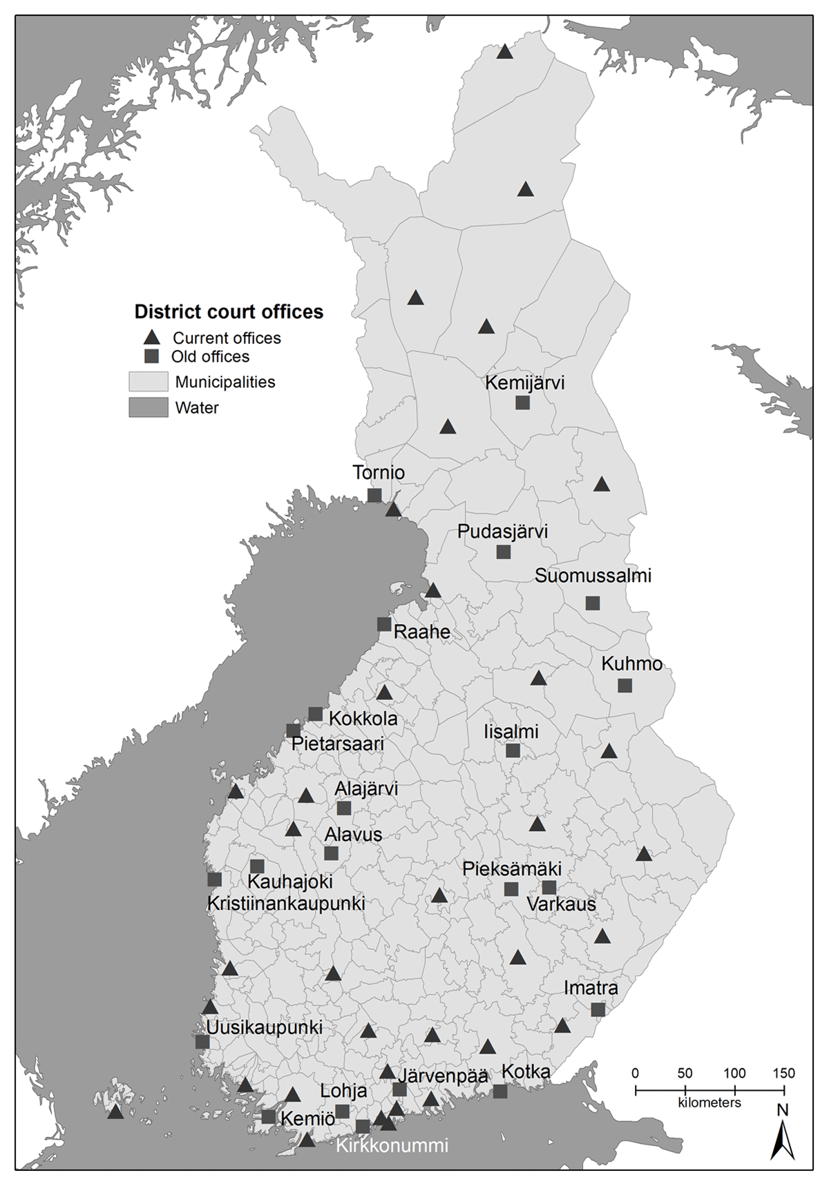
Figure 1
Old and current renewed district court networks in Finland.
Before the latest district court reform, district courts had 57 administrative offices, offices or courtrooms in total.36 On 1 January 2019, the number of district court locations decreased from 57 to 36 as a result of the reform indicating relatively big changes. Currently there are 20 administrative offices, 4 separate offices and 12 separate courtroom places in the new district court network. Overall, there are 36 locations in total when offices and courtrooms are considered. The renewed district court network is shown in Figure 1. The reform has been justified with a low utilization rate, safety deficiencies and large investments needed to update technical equipment.
The main objective of the district court reform was to strengthen the structure of the district court network so that access to justice and the quality of justice can be safeguarded in the changing environment of the future. The reform therefore aimed to create an operationally efficient and geographically comprehensive site network in a way that the district courts and their offices would be in the largest population centers. However, the aims of the reform were not analyzed or supported by the geospatial research methods, which is a reason why the geographical features were not taken into account in the reform.
4. Data and methods
4.1. GIS databases
The article’s spatial database is based on the Population Grid Data (5 km × 5 km), which contains the total population and age and gender distributions of each inhabited population grid in Finland. The grid data is produced by Statistics Finland and the population statistics are based on the year 2016.37 The population grids accurately describe, for instance, the population development despite the administrative boundaries (e.g. municipal boundaries), so this data is more suitable for demographic and regional analyses than, for example, municipal data. The accurate population grid database was selected for analysis because the results of the spatial optimization depend on how the data are aggregated,38 and with the grid database this source of error can be minimized. The geographic coverage of the spatial optimization was extensive, as the analyses of this paper used 10,303 populations grids, which covered 98.8% of the Finnish population. The total number of inhabited grids in Finland in 2016 was 10,442, so only 139 population grids were excluded from the analysis, either because they are located on islands with long ferry connections or are over 5 km away from roads.
4.2. Spatial optimization
Geospatially determined optimal location is an important element of the district court network as it can objectively maximize the geographic coverage and accessibility of the court services produced in the district courts. In this way, the optimal locations of the district court offices can enable the empirical criterion to be established for reasonable accessibility to the district court and could be used to assist in the planning and decision-making of the district court network. A location-allocation technique generally involves two steps: locating facilities and allocating resources. In the former step, a certain number of facilities are optimally selected from a potential set to provide services; in the latter step, resources are optimally allocated to a set of spatially distributed demanding sites for consumption.39 Optimality is typically evaluated with an objective function in terms of minimum average travel distance or time, maximum coverage, or minimum cost related to multiple factors. With a non-trivial role, location allocation analysis is implicated in regional planning and resource allocation for flexibility and refinement.40 Technique can be used to analyze the effects of the shrinking or expanding court service networks and they can support diverse planning processes such as rightsizing the old service networks in the aging societies like Finland. Studies on public facilities have mainly focused on deriving the optimal deployment of emergency response facilities such as ambulance sites41 or determining convenient locations for schools to minimize travel distance.42 The studies using location allocation analysis on court services seem to be systematically missing.
In this study, the optimization is based on the route network optimization of the Network Analyst application of ArcGIS software. The location-allocation tool was used to optimize the district court network so that the distance of the weighted demand points, here population grids (y), to the selected location (z) of the district courts is as small as possible.43 The use of the weighted demand points means that differences in in the population of the population grids are considered in the analysis.
Spatial optimization is done by two location-allocation methods. First, the ‘minimize impedance’ method based on the p-median problem was used to optimize the district court network. Hakimi44 defines the p-median problem as follows: the technique aims to determine the locations of P facilities such that the total travel distance from each demanding site to the closest facilities is minimized. A similar method was previously used to optimize the hospital network in Finland.45 The second, the ‘maximize attendance’ method was used in spatial optimization as a ‘contrast’ to the ‘minimize impedance’ method. The ‘maximize attendance’ (MA) technique seeks to maximize the attendance of the demand within the distances used or travel time. This method solves the neighborhood store location problem where the proportion of demand allocated to the nearest chosen facility falls with increasing distance.46 In the optimization, the set of facilities that maximize the total allocated demand is chosen.
In this article, in the optimization the population grids are weighted by population numbers that assume that demand for the district court services is similar across the country. The analysis use population as the weighting variable because it implements through the geospatial research methods the basis of the spatial justice and emphasize the geographical aspects of justice in the accessibility the district court services. The choice can also be justified by the fact that statistics on the court cases are not found in official databases. Weighting could also be based on the observed need for court services if accurate spatial data is available. Similarly, the optimization could emphasize, for example, the condition of buildings, investment in sites or the availability of skilled labor. However, the relationship between these weights should be determined and their relevance to the accessibility of the district court should be considered. This would complicate the assessment and widen the concept of geographical accessibility, so that the demand for the district courts might also be influenced by factors related to the provision of the district courts. This is not included in optimizations because, for example, in the case of a skilled workforce, it is also a matter of organizing the work within the district court, which is not necessarily directly linked to the geographical accessibility of the district court.
4.3. Accessibility analyses
Accessibility is generally described by distance, time or travel costs.47 To simplify the calculation of the accessibility, the accessibility of the district courts was described in this paper by distance. This can be justified by the fact that accessibility to the location of services is generally the most important factor affecting mobility costs, as it determines travel time and associated costs.48 The calculation did not, therefore, take account of the mode of transportation, even though it would be possible to include the mode of transportation in the calculation, but would require the compilation of a large spatial database, which is not publicly available. Planning based on public transport would also be problematic from the point of view of rural areas, as comprehensive public transport is missing in the rural areas.49 Therefore, since travel by car is an overwhelmingly dominant mode of transport in Finland, it is reasonable to restrict the analyses to this mode of transport.
In this article, the accessibility analyses from population grids to the closest district court office were implemented with ArcGIS software’s Network Analyst plug-in using the ‘closest facility’ method based on the Dijkstra algorithm. The ‘closest facility’ method finds the shortest route between two points along the defined street network so that the shortest distance calculation for the selected service can be performed on all population squares at the same time. As a result, the exact distances to the closest district court office were obtained along the road network. The accessibility information used in this article is based on the Digiroad road network from 2014.50 In the calculation, it was assumed that travel to the nearest district court would be done from the place of residence.
5. Results: Use of spatial optimization methods in Finnish district court reform
5.1. Geographic coverage and accessibility of the district court network
Before the district court reform, the geographical coverage and accessibility of the district courts could be considered good, as 92.3% of Finns lived less than 50 km away from their closest district court. As the number of district court offices declines in the renewed district court network and the geographic coverage shrinks in the reform, the accessibility was reduced, as this share dropped to 84.2% on January 1, 2019 (Table 1). The geospatial analysis shows its usefulness in the planning of the district court network, because if the reform were based on an optimized district court network where the geographic accessibility losses were minimized with the utilization of location allocation techniques, the corresponding percentage would 89.4 (Table 1). The difference between an optimized and renewed district court network is 5.2%, which corresponds to a population of 281,492 inhabitants. The figures demonstrate that geospatial analysis would help in mitigating the loss in the accessibility by indicating which courts are better geographically placed to serve more citizens. In the distance classes, the greatest difference between the renewed and optimized district court network is, in addition to the distance of less than 50 km, in the range of 51–100 km, where the difference between the renewed and optimal district court network is 5.7%, corresponding to a population of 313,972 inhabitants. The difference between optimization methods is remarkable because, with the ‘maximize attendance’ method, the share of population that lives less than 50 km from the closest district court is 20% smaller than with p-median optimization (Table 1).
Table 1
Accessibility of the closest district court by distance range in the old (before reform) and renewed (after reform) district court networks and their optimized district court networks (Optimal (57) and Optimal (36)) with p-median and ‘maximize attendance’ techniques.
| ACCESSIBILITY | % OF POPULATION | |||||
|---|---|---|---|---|---|---|
| OBSERVED NETWORKS | OPTIMIZED NETWORKS WITH P-MEDIAN | OPTIMIZED NETWORKS WITH ‘MAXIMIZE ATTENDANCE’ | ||||
| OLD, BEFORE REFORM IN 2019 (57 LOCATIONS) | RENEWED, AFTER REFORM IN 2019 (36 LOCATIONS) | OPTIMAL (57 LOCATIONS) | OPTIMAL (36 LOCATIONS) | OPTIMAL (57 LOCATIONS) | OPTIMAL (36 LOCATIONS) | |
| ≤50 km | 92,3 | 84,2 | 94,5 | 89,4 | 79,2 | 69,1 |
| 51–100 km | 7,5 | 15,0 | 5,3 | 9,3 | 17,7 | 26,1 |
| 101–150 km | 0,2 | 0,8 | 0,2 | 1,1 | 2,7 | 3,9 |
| 151–200 km | 0 | 0 | 0 | 0,1 | 0,3 | 0,8 |
| >200 km | 0 | 0 | 0 | 0,1 | 0,1 | 0,1 |
| Average (km) | 17,1 | 23,3 | 19,9 | 24,4 | 33,4 | 39,8 |
| Median (km) | 9,6 | 12,5 | 15,6 | 17,9 | 24,2 | 29,2 |
In the old district court network, the average distance to the closest district court was 17.1 km. In the renewed network, however, the average distance to the closest district court increased by an average of 6.2 km for every Finn after the reform. Compared to an optimized 36-site district court network, the average reach of the nearest district court would have been extended by 7.3 km by the p-median method and by 22.7 km by the ‘maximize attendance’ method. The average distance is slightly increased in comparison to renewed and optimized p-median district court networks because the p-median method minimizes the distance between the median and the closest district court, not the citizens.
Figure 2 visualizes the locations of the district courts in the old and renewed district court networks. In terms of geographical coverage, especially in Eastern and Central Finland, there are sub-regions where the district court was lost in the reform, even though the spatial p-median optimization technique would have supported the allocation of a district court in the region as part of the optimized district court network. Figure 2 also demonstrates that the old district court network was not optimal in terms of accessibility. This also shows that the previous district court reforms did not seek to form a spatially optimal district court network with the good accessibility.
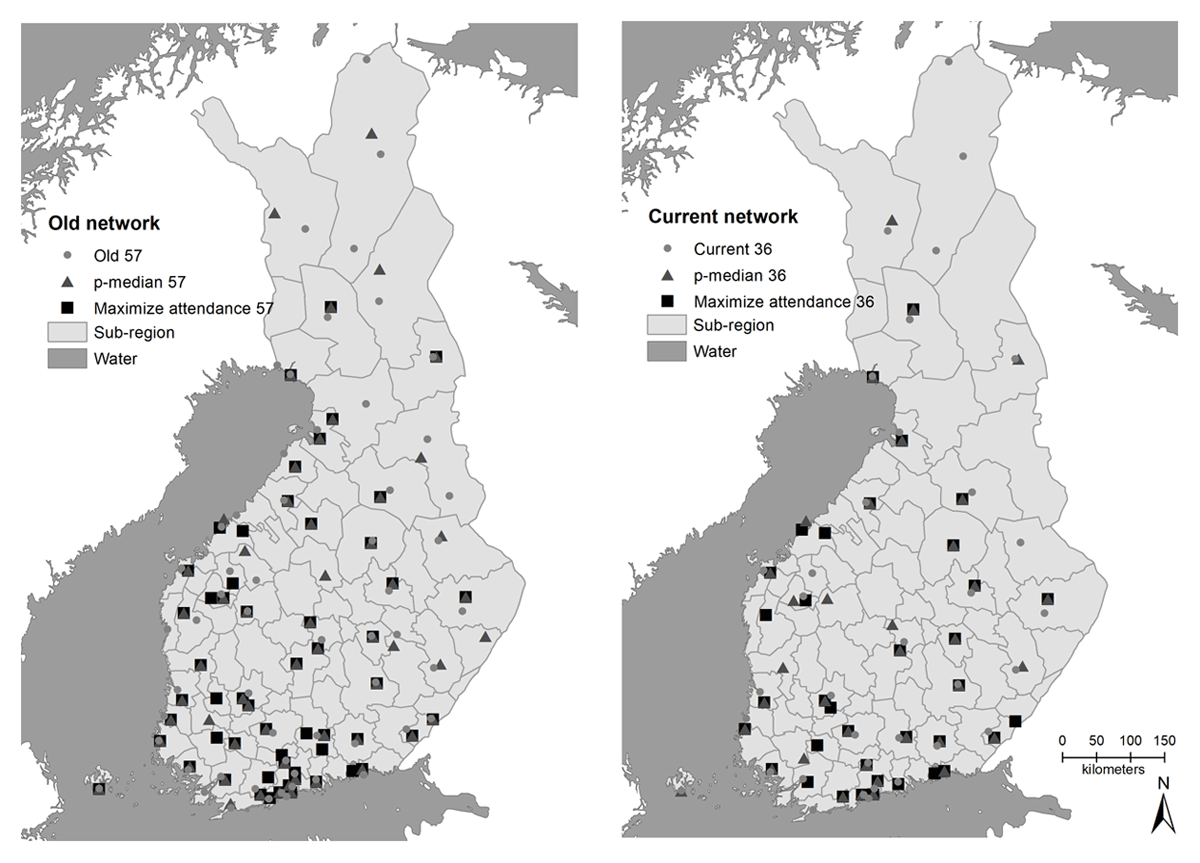
Figure 2
Old and current renewed district court networks and their optimized locations with p-median and ‘maximize attendance’ techniques. The regions in the figure represent sub-regions.
The geographic coverage of the offices of the optimized district court network, measured by distance, is heavily improved by increasing the size of the district court network up to about ten locations (Figure 3). As the district court network expands from one office to 25 offices, the average distance to the closest district court declines by 180 km from 211 km to just 31 km by p-median optimization. Based on the simple regression model, the average accessibility of district courts is improved by 2.1 km for every Finnish district court office added to the network (regression model a = 106.965, b1 = –2.061 (p-value 0.013), r2 = 0.419). The interpretation of the network size of about 25 sites appears to limit the reasonable accessibility of district courts. When the size of the district court network exceeds 25, the improvement in accessibility begins to deteriorate even if the number of offices in the network increases. This can be seen from the regression model, which is estimated for network sizes of 30 to 55, as the regression coefficient (b1) falls to –0.268 (p-value < 0.001), indicating that increasing the size of the district court network by one office would improve the average accessibility by 0.268 km. At the same time, the social benefit of expanding and decentralizing the district court network also deteriorates. For example, increasing the number of district court offices from 30 to 55 locations in the network shortens the average distance to the closest district court by only 6.7 km.
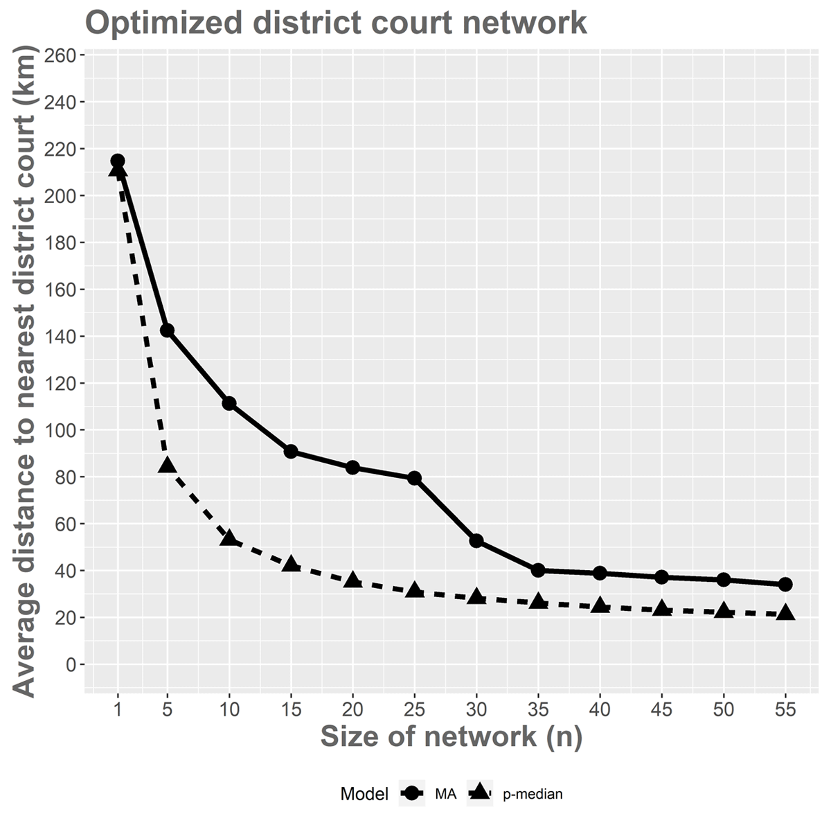
Figure 3
The average distance to the nearest district court and the size of the district court network with p-median and ‘maximize attendance’ techniques.
There are large differences between optimization techniques (Figure 3). With the ‘maximize attendance’ technique, there are incentives to enlarge the district court network to 35 offices when the average accessibility is still weaker than with the p-median technique with 25 offices. With the ‘maximize attendance’ technique, when the size of the district court network exceeds 35, the improvement in accessibility begins to deteriorate, even if the number of offices in the network increases. The difference between techniques indicates that optimization techniques and reasoning behind the different techniques have a high impact on the spatial network of the district court network. On the basis of the regression model, accessibility in the optimized network with the ‘maximize attendance’ technique is improved by an average of about 2.7 km per open office, which is higher than the corresponding value of the p-median technique, but the intercept of the ‘maximize attendance’ regression model is also higher than in the p-median regression model (regression model a = 155,017, b1 = –2.717 (p-value <0.001), r2 = 0.764).
5.2. Geographical changes in the accessibility of district courts
The spatial optimization results described in the previous sections are based on averages, so do not illustrate local changes in the accessibility of the district courts in Finland. The changes in local accessibility due to district court reform can be illustrated on the map showing the changes in the accessibility between the old and current renewed district court networks and current renewed and the optimized district court networks. The p-median technique was selected for optimization because it seems to offer a valid criterion for allocation of the court services in a sparsely populated country.
Figure 4 shows the changes in accessibility of the population grids between the renewed 36 offices and old 57 offices. The dark gray areas shown in Figure 4 lost out in the reform (the left side of the figure), because in these regions the distance to the nearest district court is longer than before the reform. The distances to the nearest district court grow the most in the sub-regions located, for example, in Eastern Lapland and large areas in the provinces of Central and Southern Ostrobothnia (Figure 4). The changes in accessibility are remarkable because, with a total of 593,517 residents, the distance to the nearest district court is extended by more than 20 km and, for 266,173 residents, this distance is longer than 50 km, which corresponds to approximately 4.9% of the Finnish population.

Figure 4
Differences in the accessibility of the nearest district court.
In Figure 4 on the right, the current district court network is compared to an optimized equivalent-sized 36-site district court network. Here again, the losers are partly the same areas as in the previous comparison, but the new losers, the dark gray areas, appear on the map in the suburbs of Kristiinankaupunki, Raahe and Punkalaidun (Figure 4). These sub-regions would have a district court office in an optimized district court network, but this is missing from the current district court network. The beneficiaries of the current network compared to the optimized network, the areas colored light gray, are, for example, the northern parts of Lapland and the sub-regions of Pielinen Karelia, and Porvoo (Figure 4).
The mismatch in the current district court network in relation to the optimized network is remarkable: the distance to the nearest district court will be extended by more than 20 km for 429,335 inhabitants while correspondingly it will be shortened by more than 20 km for only 297,299 inhabitants. The distance to the nearest district court is extended by more than 50 km for 120,640 residents, while it is reduced by more than 50 km for only 41,637 inhabitants. In the current network, therefore, the district courts are locally more distant than in the optimally planned network. From the point of view of accessibility, this unnecessary increase in the distance to the closest district court could have been avoided by using geospatial optimization in the planning process of the current district court network.
6. Discussion
The results of this article highlight two important findings about the district court reform in Finland and the use of geospatial methods as ways of planning the district court network. Firstly, the results show that district court reform is not geographically optimal, so for some citizens the distance to the nearest district court is unnecessarily lengthened, even in extreme cases, potentially jeopardizing their access to courts. In p-median optimization, the distance to the nearest district court will be unnecessarily extended by 78,967 inhabitants, which corresponds to approximately 1.5% of the Finnish population. The spatial injustice revealed by unnecessary displacement of district courts from citizens justifies the criticism of the current district court network, even though the numbers are relatively small.
The second important finding in the accessibility calculations was that, in the future, the district court network cannot be reduced by very much in Finland without radically worsening the accessibility of the nearest district court. The low population density of Finland, fragmented community structure and long distances between urban areas were reflected in spatial optimizations, with the average distance to the nearest district court extending greatly as the district court network becomes thinner. From the point of view of the geographical coverage and accessibility of the district court network, therefore, there are no incentives to reduce the size of the district court network to less than 25 district court offices if the planning of the network is based on the p-median technique. At the same time, a reasonable average distance of approximately 31 km was determined in a 25-office district court network. The results underline the need for new ways to develop the accessibility of district courts through digitalization. Thus, the next structural development of the district court network in Finland should be based on the development of functionality if the distances are not to increase further.
6.1. Policy considerations
This study was motivated by the need to evaluate the potential impacts on accessibility and service provision resulting from the district court reform in Finland. This kind of assessment of the geographical accessibility was not conducted during the reform preparation and planning process before the year 2019. Thus, the implications of accessibility reforms have been largely overlooked in Finland in decision making. This study offers two important findings is respect to decision making.
A first important finding is that, in the reform, the accessibility gap for the optimized district court network of the same size is greater than the district court network before the reform. There is thus a risk of increasing this difference if the district court network is further reduced in the future without enough knowledge of the geographic characteristics of the district court network. This observation highlights the need to increase the use of geospatial information in the preparation of possible future district court reforms, as the reforms seem to expose citizens to the unnecessarily lengthening of distances to the nearest district court when the number of district court offices declines significantly. In this respect, the result confirms the view that using a comprehensive knowledge base will improve the quality and effectiveness of the decision-making. The impact of the current reform needs to be monitored as required by the Finnish Parliament’s Committee on Legal Affairs (LaVM 11/2017 vp) in order to provide enough information on how the reform will affect the provision of court services and their geographical accessibility.
The second important observation is that the geospatial methods used in the article are well suited to assessing district court reform and assisting in decision-making on the geographic structure of the district court network. However, the latest reform did not use geographical information about the network in the planning process, which means that decision makers are unfamiliar with these geographical issues and techniques should be better informed about geospatial analysis and its possibilities. Due to the optimality of the solution networks, recommendations for allocating district courts using the location-allocation technique should carry a greater weight in decision-making. However, the differences between different location-allocation techniques should be considered and openly state the reasons for using a certain optimization method. In the Finnish example, the sparse population structure underlined the need for p-median optimization in order to guarantee equal access to district courts. It should be noted that the geospatial optimization methods provide an objective basis for planning and developing the district court network.
6.2. Limitations of the Study
Aside from the fact that this study was designed to focus solely on geographic accessibility, thus excluding many other factors affecting the provision of court services, we acknowledge there are several limitations involved in analyses performed in the study. For instance, the geographic accessibility was measured only by distance to the closest district court office, but in future research it would also be possible to integrate, for example, the maintenance and transportation costs of the district court network into spatial optimization. In this case, the economic consequences of the reform and the associated incentives could be further assessed. At the same time, there could be a holistic view of how it would be economically viable to produce district court services in a decentralized or centralized manner.
7. Conclusions
Even if the importance of service accessibility has been generally understood, it has not been widely taken into consideration in organizing court services in Finland. A possible explanation for this is that aspects related to accessibility have only become important as a result of the centralization of court services due to district court reform in 2019. Accessibility has not been a major concern in the era of expanding court services but after relatively big changes because of the centralization process it has become a more important factor in the future determining the district court network. The negative impacts on accessibility may become increasingly pronounced in the future.
In this article, spatial optimization techniques were used to operationalize a reasonable average distance to the closest district court office and set a threshold at which the average distance to the nearest district court remained reasonable. This threshold can be considered as a criterion for reasonable access to district courts in future reforms, and information can also be used to consider future priorities for the development of the district court network. The geographically scattered and sparse population structure in Finland requires smaller district court offices to be retained especially in remote areas in the north, despite centralization efforts and policies. Nevertheless, a country-wide analysis of accessibility concerning the district court network can be advocated as a fundamental tool for decision-making.
Notes
[1] See K. Economides, K. Blacksell & C. Watkins, The Spatial Analysis of Legal Systems: Towards a Geography of Law. Journal of Law and Society 13 (2) 1986, pp. 161–181; D. Weisburd, E. R. Groff & S. M. Yang, The Criminology of Place: Street Segments and Our Understanding of the Crime Problem. Oxford University Press 2012, p. 6.
[2] K. Curtin, K. Hayslet-McCall & F. Qiu, Determining Optimal Police Patrol Areas with Maximal Covering and Backup Covering Location Models. Networks and Spatial Economics 10, 2010, pp. 125–145.
[3] L. Kennedy, J. Caplan, E. Piza & H. Buccine-Schraeder, Vulnerability and Exposure to Crime: Applying Risk Terrain Modeling to the Study of Assault in Chicago. Applied Spatial Analysis and Policy 9 (4) 2016, pp. 529–548.
[4] G. Drawve, A Metric Comparison of Predictive Hot Spot Techniques and RTM. Justice Quarterly 33 (3) 2016, pp. 369–397.
[5] J. Caplan, L. Kennedy, & J. Miller, Risk terrain modeling: Brokering criminological theory and GIS methods for crime forecasting. Justice Quarterly 28 (2) 2011, pp. 360–381.
[6] J. Caplan, L. Kennedy & J. Barnum, Risk terrain modeling for spatial risk assessment. Cityscape: A Journal of Policy Development and Research 17 2015, pp. 7–16; W. Moreto, E. Piza & J. Caplan, A plague on both your houses? Risks, repeats, and reconsiderations of urban residential burglary. Justice Quarterly 31 (6) 2014, pp. 1102–1126.
[7] M. Blacksell, Social justice and access to legal services: a geographical perspective. Geoforum 21 (4) 1990, pp. 489–502; R. Thomas, B. Robson & R. Nutter, Planning the Work of Country Courts: A Location-Allocation Analysis of the Northern Circuit. Transactions of the Institute of British Geographers 16 1991, pp. 38–54; F. Rømo, I. A. F. Sætermo, New courts of first instance: A model for analysis of optimal location of courts of first instance in Norway. SINTEF report STF38 A00613 (technical report), Trondheim, Norway, 2000; J. C. Teixeira, J. F. Bigotte, H. M. Repolho & A. P. Antunes, Location of courts of justice: The making of the new judiciary map of Portugal. European Journal of Operational Research, 272 (2) 2019, pp, 608–620.
[14] Finlex Data Bank, The Constution of Finland (731/1999 English). Translations of Finnish acts and degrees. <https://www.finlex.fi/en/laki/kaannokset/1999/en19990731> [accessed 13 December 2020].
[15] M. de Smith, M. Goodchild, & P. Longley, Geospatial analysis: a comprehensive Guide to principles, techniques and software tools. Leicester: Troubador Ltd, 2005, p. 516.
[19] See Government proposal HE 246/2014 vp to Parliament for acts amending Chapter 25 and 25a of the Code of Judicial Procedure and Section 3 of the Military Court Procedure Act.
[20] Ministry of Justice Finland, Report of the Committee on the Development of the Judiciary. White paper 2003:3. <https://julkaisut.valtioneuvosto.fi/handle/10024/75857> [accessed 25 May 2020].
[23] Report of the Committee on Legal Affair 11/2017 on government proposal HE 270/2016 vp to Parliament for acts amending the Courts Act and certain other related acts.
[24] N. Chappe, M. Obidzinski, The impact of the number of courts on the demand for trials. International Review of Law and Economics 37 (C) 2014, pp. 121–125.
[27] H. Niskanen, T. Ahonen & A. Laitinen, Suomalaisten luottamus tuomioistuimiin. Turun yliopiston oikeustieteellisen tiedekunnan julkaisuja. Rikos- ja prosessioikeuden sarja A N:o 25. Turku, 2000.
[28] J. Sorabji, Initial Reflections on the Potential Effects of the Covid-19 Pandemic on Courts and Judiciary of England and Wales. International Journal for Court Administration 12(2) 2021. DOI: https://doi.org/10.36745/ijca.394.
[29] E. Rowden, Distributed Courts and Legitimacy: What do we Lose When we Lose the Courthouse? Law, Culture and the Humanities 14 (2) 2018, pp. 263–281.
[30] J. Eisenstein, H. Jacob, Felony Justice: An organizational Analysis of Criminal Courts. Boston: Little, Brown and Company, 1977.
[32] Government proposal HE 270/2016 vp to Parliament for acts amending the Courts Act and certain other acts. (HE 270/2016 vp).
[33] Government proposal HE 28/1986 vp to Parliament for legislation to harmonize general lower courts; S. Laukkanen, Oikeuslaitoksen rakennemuutos – toteuttamiskelpoinen suunnitelma? in E. Havansi – R. Koulu & H. Lindfors (eds.), Oikeudenkäyntejä ja tuomioistuimia. Juhlakirja Juha Lappalainen 60 vuotta. COMI ja Edita Publishing Oy 2007, pp. 245–262; Käräjäoikeusverkoston kehittämistyöryhmä, Käräjäoikeusverkoston kehittäminen. Oikeusministeriön mietintöjä ja lausuntoja 14/2015.
[34] Statistics Finland, Finland in Figures, 2020. <https://www.tilastokeskus.fi/tup/suoluk/index.html> [accessed 12 December 2020].
[35] V. Helminen, K. Nurmio & S. Vesanen, Kaupunki-maaseutu-alueluokitus 2018. Paikkatietopohjaisen alueluokituksen päivitys (English abstract: Urban-rural classification). Suomen ympäristökeskuksen raportteja 21 / 2020, pp. 32. <https://helda.helsinki.fi/handle/10138/315440> [accessed 1 July 2020].
[37] Statistics Finland, Population grid data 5 km × 5 km, 2017 <https://www.stat.fi/org/avoindata/paikkatietoaineistot/vaestoruutuaineisto_5km.html> [accessed 25 May 2020].
[38] A. Fotheringham, P. Densham & A. Curtis, Zone definition problem in location-allocation modeling. Geographical Analysis 27 (1) 1995, pp. 60–77.
[39] Z. Drezner, H. W. Hamacher, Facility Location: Applications and Theory. New York: Springer, 2004.
[40] S. Rahman, D. K. Smith, Use of location-allocation models in health service development planning in developing nations. European Journal of Operational Research 123 (3) 2000, pp. 437–452.
[41] E. Erkut, A. Ingolfsson & T. Sim, Computational Comparison of Five Maximal Covering Models for Locating Ambulances. Geographical Analysis 41 (1) 2009, pp. 43–65.
[42] F. Ndiaye, B. M. Ndiaye & I. Ly, Application of the p-Median Problem in School Allocation. American Journal of Operations Research 2 2012, pp. 253–259.
[43] H. J. Miller, S.-L. Shaw, Geographic information systems for transportation: principles and applications. New York: Oxford University Press, 2001, p. 458.
[44] S. L. Hakimi, Optimum Locations of Switching Centers and the Absolute Centers and Medians of a Graph. Operations Research, 12 (3) 1964, pp. 450–459.
[45] T. Huotari, H. Antikainen, T. Keistinen & J. Rusanen, Accessibility of tertiary hospitals in Finland: a comparison of administrative and normative catchment areas. Social Science & Medicine 182 2017. pp. 60–67; T. Huotari, J. Rusanen, T. Keistinen, T. Lähderanta, L. Ruha, M. Sillanpää & H. Antikainen, Effect of centralization on geographic accessibility of maternity hospitals in Finland. BMC Health Services Research 20:337 2020, pp. 1–9.
[46] J. Holmes, F. Williams & L. Brown, Facility Location Under a Maximum Travel Restriction: An Example Using Day Care Facilities. Geographical Analysis 4 (3) 1972, pp. 258–266; S. M. Algharib, Distance and Coverage: An Assessment of Location-Allocation Modeles for Fire Stations in Kuwait City, Kuwait. Doctor of Philosophy, Kent State University, 2011.
[47] M. P. Kwan, Space-Time and Integral Measures of Individual Accessibility: A Comparative Analysis Using a Point-based Framework. Geographical Analysis 30 (3) 1998, pp. 191–216.
[48] J.-P. Rodrigue, C. Comtois & B. Slack, The Geography of Transport Systems. Third Edition. Routledge, 2013.
[49] M. Ristimäki, Relationships between commuting distance, frequency and telework in Finland. Journal of Transport Geography 15 (5) 2007, pp. 331–342.
[50] Finnish Transport Agency, Digiroad, Descripion of data types, version 2.2, 2015. http://www.digiroad.fi/dokumentit/fi_FI/dokumentit/_files/84853505707737499/default/Digiroad_tietolajien_kuvaus_22.pdf.
Competing Interests
The authors have no competing interests to declare.