Have a personal or library account? Click to login
Water stable isotopes in the Yarlungzangbo headwater region and its vicinity of the southwestern Tibetan Plateau Cover

Water stable isotopes in the Yarlungzangbo headwater region and its vicinity of the southwestern Tibetan Plateau

By: ,   and    
Open Access
|Jan 2016

Figures & Tables

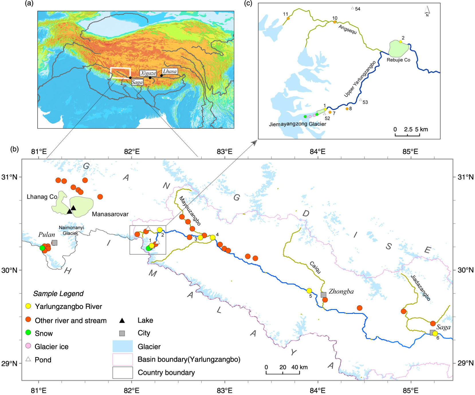
Fig. 1

(a) Geographical location of the Yarlungzangbo headwater region; (b) sample location map of various waters from the Yarlungzangbo headwater region and its vicinity, showing the upper Yarlungzangbo flows from the Jiemayangzong Glacier in the western Himalaya to the site near Saga; (c) sample location map of waters in the Yarlungzangbo source area. Some sample numbers are also shown.
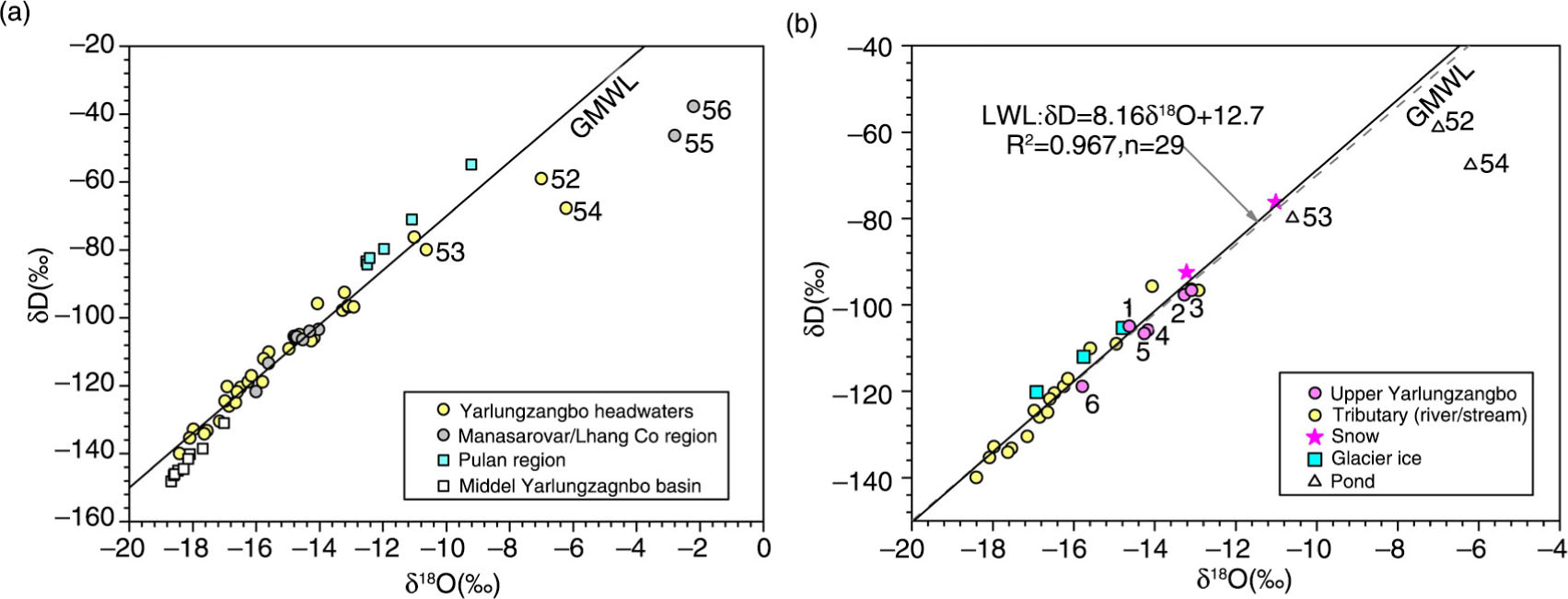
Fig. 2

(a) δ18O and δD results of all waters in relation to the GMWL (δD=δ18O+10) (samples are divided into four categories based upon their geographical locations and the lake/pond sample numbers are shown); (b) δ18O and δD results of various types of water in the Yarlungzangbo headwaters. The local water line (LWL) is developed using isotopic data of snow, ice, river and stream samples.

Table 1. Sample localities and measured isotopic data

SampleSampling dateLat. (°N)Long. (°E)Sampling elevation (m a.s.l.)δ18O (‰)δD (‰)d-excessc (‰)NoteRiver/stream waters1a2012/07/1630.254882.21355064−14.64−104.912.2Main flow (outflow of the JMYZ Glacier lake)2a2012/07/1630.432482.30184943−13.27−97.78.5Main flow (Rebujie Co lake)3a2012/07/1630.350782.73804719−13.09−96.78.0Main flow (above the confluence with Mayouzangbo)4a2012/07/1630.350782.87054670−14.18−105.87.6Main flow (below the confluence with Mayouzangbo)5a2012/07/1829.778583.90674584−14.26−106.67.5Main flow (outflow of a large flow-through lake)6a2012/07/1829.319485.25924477−15.79−118.87.5Main flow (near Saga)72012/07/0330.261882.22685026−14.96−10910.7Stream (near the JMYZ Glacier)82012/07/0330.280582.25745027−13.10−96.48.4Stream (near the JMYZ Glacier)92012/07/0330.352582.62164773−12.92−96.76.7Stream102012/07/0930.400582.13905037−15.60−11014.8River (Angsequ)112012/07/0930.373782.06185270−14.07−95.716.9Stream122012/07/0230.258381.10013905−12.53−83.416.8Stream (near Pulan)132012/07/0230.258081.06464294−11.09−71.017.7Stream (near Pulan)142012/07/0230.293081.16533916−12.50−84.315.7Stream (near Pulan)152012/07/0230.231881.10444616−11.96−79.716.0Stream (near Pulan)162012/07/0230.209581.06594773−12.42−82.417.0Stream (near Pulan)172012/07/0230.965081.21134637−15.60−113.311.5Stream182012/07/0230.957081.27524626−14.75−105.912.1Stream192012/07/0230.890181.37304627−14.71−105.612.1Stream202012/07/0530.861281.42684631−14.03−103.48.9Stream212012/07/0230.838781.45254625−14.52−106.39.9Stream222012/07/0530.966481.50004870−14.32−103.910.6Stream232012/07/0230.776781.61374623−16.00−121.66.4Stream242012/07/0230.537682.57514923−16.49−120.411.5River (Mayouzangbo)252012/07/0430.520882.60424874−16.85−125.98.9River (Mayouzangbo)262012/07/0230.496482.61534836−16.25−118.811.2River (Mayouzangbo)272012/07/0430.373682.78034730−16.15−117.012.2River (Mayouzangbo)282012/07/0230.276482.94914653−16.65−124.88.4Stream292012/07/0330.232482.99414640−16.98−124.411.4Stream302012/07/0330.215783.01584630−16.59−121.711.1Stream312012/07/0330.132183.30714608−17.15−130.46.8Stream322012/07/0330.128083.32844594−17.55−133.27.2Stream332012/07/0329.711784.06974569−18.41−139.97.4River (Caiqu, near Zhongba)342012/07/1729.593184.44774576−17.98−132.811.0Stream352012/07/1729.556884.91984651−17.64−134.17.0River (Jiadazangbo)362012/07/1729.427485.23424715−18.09−135.39.4Stream37b2012/07/1829.472485.95214887−18.09−140.14.6River (Qiangxiongzangbo)38b2012/07/1829.482586.02664814−18.46−145.02.7Stream39b2012/07/1829.479786.19094790−18.67−148.11.3Stream40b2012/07/1829.492086.49114655−17.68−138.52.9River (Duoxiongzangbo)41b2012/07/2029.320687.01444454−18.60−146.32.5Stream42b2012/07/2029.087988.03874266−18.57−146.02.6Stream43b2012/07/2029.149888.08734150−18.29−144.51.8Stream44b2012/07/2029.212588.36953877−18.15−141.63.6Stream45b2012/07/2029.275488.89623839−17.02−131.05.1River (Nyangqu, near Xigaze)Surface snow462012/07/1630.247282.20425116−13.21−92.513.2In ablation zone of the JMYZ Glacier472012/07/1630.235682.18225334−11.01−76.211.9In ablation zone of the JMYZ Glacier482012/07/0230.238381.03944842−9.22−54.818.9Near PulanGlacier ice492012/07/1630.235382.18505307−15.76−11214.1In ablation zone of the JMYZ Glacier502012/07/1630.238982.19225239−16.92−120.215.1In ablation zone of the JMYZ Glacier512012/07/1630.244282.20035143−14.79−105.412.9In ablation zone of the JMYZ GlacierPond water522012/07/1630.257282.21745096−7.00−59.0−3.0Deep (~3 m), with no outlet/inlet, near the JMYZ Glacier lake532012/07/1630.313682.28165057−10.64−79.95.2Large, shallow and connected with the main channel through a narrow opening542012/07/0930.435382.18135018−6.22−67.7−18.0Shallow, with no outlet/inlet, far from any river channel or glacierLake water552012/07/0130.714481.37074598−2.79−46.3−24.0The lake of the Manasarovar562012/07/0130.665081.32154680−2.20−37.7−20.1The lake of the Lhanag Co

[i] aMain flow of the upper Yarlungzangbo. bOut of the range of Fig. 1b and were sampled from Xigaze westward to Saga. cd-excess=δD – 8δ18O.
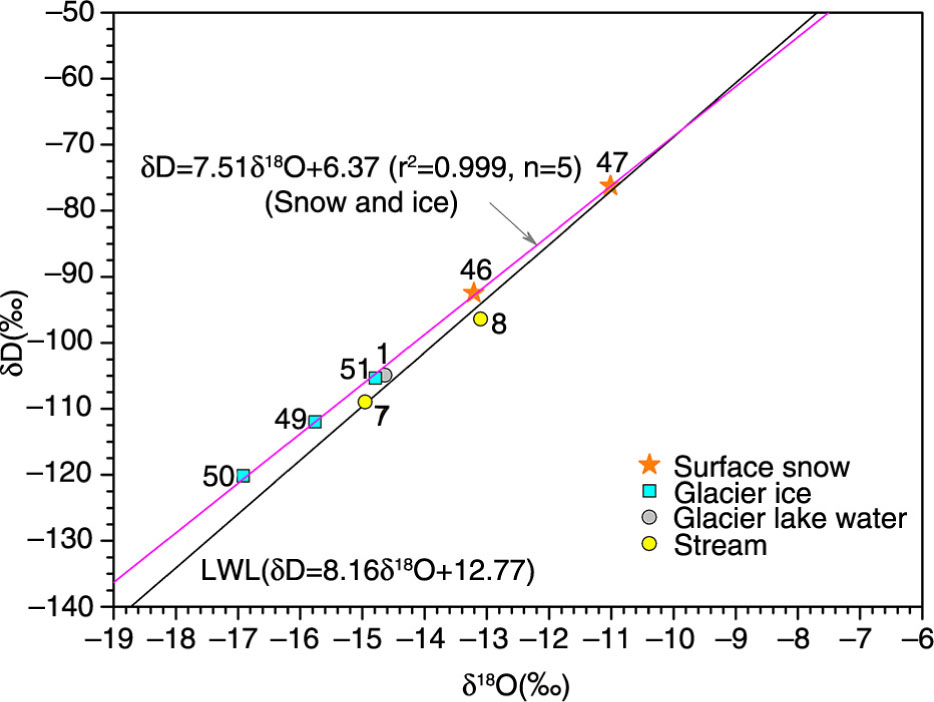
Fig. 3

δ18O and δD of surface snow/glacier ice (in the ablation zone of the Jiemayangzong Glacier), glacier lake and stream water samples in the Jiemayangzong Glacier area.
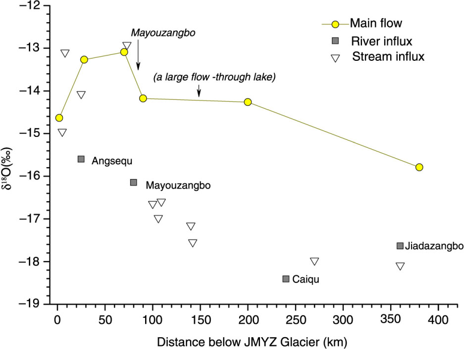
Fig. 4

Main flow (upper Yarlungzangbo) and tributary influx δ18O vs. distance downstream from the JMYZ Glacier (0 km) to Saga (~370 km).
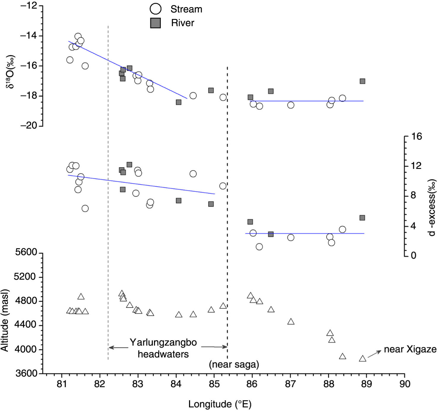
Fig. 5

Plot of river/stream δ18O, d-excess and sampling altitude vs. longitude. These samples do not include main flows in the Yarlungzangbo and waters collected from the western Himalaya. Blue lines represent individual variation trends for each section.
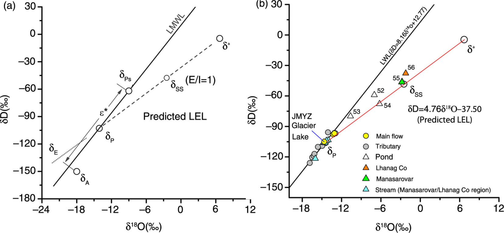
Fig. 6

(a) Schematic representation of the buildup of the predicted LEL relative to LMWL (local meteoric water line) for a given region. δps is the isotopic composition in precipitation in average thaw season. δA is the average isotopic composition in evaporative-flux-weighted atmospheric moisture and is assumed to be in approximate isotopic equilibrium with δps. δss is the isotopic composition in a terminal (closed-drainage) basin fed by annual mean precipitation with an isotopic value of δp in a steady state (evaporation=inflow, E=I). δ* represents the theoretical limiting isotopic composition attainable for water bodies under average evaporative conditions in summer (Appendix A). (b) Isotopic compositions in various waters from the Yarlungzangbo source region (above the confluence with the Mayouzangbo) and the Manasarovar/Lhanag Co region in relation to the LWL and the predicted LEL.

Language: English
Page range: 30397 - 30397
Submitted on: Nov 13, 2015
Accepted on: May 16, 2016
Published on: Jan 1, 2016
Published by: Stockholm University Press
In partnership with: Paradigm Publishing Services

© 2016 Wei Ren, Tandong Yao, Shiyou Xie, published by Stockholm University Press
This work is licensed under the Creative Commons Attribution 4.0 License.