
1. Introduction
A lake is a considerable volume of water within a land depression without inlet from a sea. Lakes occupy only about 1.8% of the land surface but are distributed very irregularly. Turbulent and radiation fluxes from lakes and from land surface differ a lot, thus lakes influence local weather conditions and local climate (Eerola et al., 2010; Samuelsson et al., 2010). In regions with a large number of lakes such as Canada, the Scandinavian Peninsula, Finland, Northern Russia, their influence is of particularly importance. For regions with a small number of lakes, their influence is less pronounced, but still not negligible. Lakes are also involved in a carbon cycle (Tranvik et al., 2009), and thermokarst lakes are among the sources of methane (Walter et al., 2007), which means that lakes may noticeably influence global climate. The effect of lakes should be parameterised in numerical weather prediction (NWP) and climate modelling. Sometimes a proper description of a lake state in a model may help prevent serious errors in a forecast (K. Eerola, personal communication 2014). A lake parameterisation becomes more influential with an increase of a model horizontal resolution and when a model grid box is divided into several different surface types. Therefore, even small-size lakes become visible on a model grid.
NWP and climate models need a computationally cheap lake model for the parameterisation of lakes. Currently, for this purpose many atmospheric models use the bulk (zero-dimensional) lake model FLake (Mironov, 2008). Information about characteristics of lakes (external model parameters) is also necessary. Atmospheric models need gridded data. Therefore, lake data should be provided in a gridded form. Lake fields should be global and contain information about all existing lakes. Lake depth is the most important parameter used by all lake models. We may use the bathymetry when it is available, or for middle and small size lakes we may use the mean lake depth, which is recognised to be a reasonable approximation in atmospheric applications, when we are mainly interested in surface lake processes on large scales. Moreover, for atmospheric modelling (in contrast with hydrological), an accuracy and even a reliability of depth data are not critical, but a global coverage is essential. In the absence of direct measurements, indirect estimates, though less precise, can be used.
For the parameterisation of lakes in NWP and climate modelling, Global Lake Database (GLDB) (Kourzeneva, 2009; Kourzeneva et al., 2012a) was developed. It contains gridded data on the lake depth and includes slightly more than 13000 lakes in its first version (GLDBv.1). However, the recently assumed number of lakes in the world exceeds 8 million. Most lakes, especially of small size, were never inspected to measure the depth. To estimate the depth of the uninspected lakes, it is natural to assume (Doganovsky, 2006; Doganovsky, 2012) that water bodies of the same origin and the same age should have a similar size. For example, it is widely known that tectonic lakes are deeper than glacial, karst lakes usually have small surface area, but are rather deep, and eolian lakes are usually shallow. So, different information, for example, about the geological origin of lakes, could be used to estimate the lake depth indirectly (Kondratiev, 2010).
There are many studies devoted to estimations of the lake depth and the water transparency characteristics on the basis of richness in nutrients and/or mineralisation and soil type of a surrounding landscape (Canfield et al., 1985; Lee and Rast, 1997). However, richness in nutrients is hard to determine precisely without any direct observations. Besides, different studies propose different methods for different parameters based on statistics from different territories, and these results need to be generalised. Hence, resulting maps would have low accuracy. We should also mention an attempt described in Balsamo et al. (2010) to estimate the lake depth by variational methods, using the annual lake water surface temperature measurements from remote sensing and a lake model. The main problem with this approach is errors in remote sensing data.
As for geological origin of lakes, in literature we found only two studies devoted to its relation to the lake depth and size. In Doganovsky (2012) and Doganovsky (2006), lake volume is estimated as a function of the lake area with the regional coefficients dependent on the regional geology mostly of the Quaternary period. From the lake volume and the lake area, the mean lake depth may be easily calculated. Hereafter, we refer to this method as ‘improved geomorphologic’. Unfortunately this method is developed only for the Baltic region and is not applicable for very small lakes. The method described in Kitaev (1984) is based on geographical zones (we refer to it as ‘geographical’). Different lake characteristics are considered to be dependent on the geographical zone, where the lake is located. Only geographical zones belonging to the boreal zone are considered. This method has low accuracy. A detailed description of both methods can be found in Sections 4.3 and 4.4. Since each of them has their advantages and disadvantages, in our study they were used only in addition.
The main purpose of our study is to upgrade the GLDB for parameterisation of lakes in atmospheric modelling (Kourzeneva et al., 2012a) by indirect estimates of the mean depth for lakes in a boreal zone on the basis of their geological origin. Estimates are obtained from statistical and expert evaluation. First, we outlined boundaries of regions with kindred geological origin of lakes. Second, we proposed a typical lake depth for these regions. Finally, the new version of GLDB was developed. It includes typical mean depth estimations from the geological origin of boreal lakes. Section 2 describes data sources of the study, namely GLDBv.1 and different maps which were used. Section 3 describes methodology of allocating regions with kindred origin of lakes. Section 4 is devoted to expert evaluation to propose the typical lake depth for allocated regions from statistical analysis, method of analogies, improved geomorphologic and geographical methods. Section 5 presents the new product. Section 6 demonstrates a sensitivity of modelling results to the upgrades in GLDB. Section 7 presents our conclusions of the study.
The study is interdisciplinary. The problem was formulated by the meteorological community, which is the main user of the product and defines main requirements to it. However to solve it, knowledge from hydrology and hydrogeology was necessary. To outline regions with typical geological origin of lakes, we used an approach which we refer to as ‘the bottom-up approach’ in the rest of the paper. We started from information about the deepest layers of the Earth crust from Tectonic Plates Map, then we applied data about middle layers from the geological map, then about upper layers from the map of Quaternary deposits and finally about the top layer from the geomorphologic map. We considered first the boreal zone, making the first step forward to global estimates. Even nowadays, this climate zone remains the most explored, as it was in the mid-80s, when the first study generalising morphological characteristics of lakes appeared (Kitaev, 1984). Northern boundary of the boreal climate zone was considered to be the North Pole. Southern boundary was drawn in the Northern hemisphere at 30° latitude for the North America continent, 50° latitude for the Europe continent (westward from the 40° longitude) and 40° latitude for the Asia continent (eastward from the 40° longitude).
2. Data sources
2.1. GLDBv.1 and the mapping method
GLDB (Kourzeneva, 2009; Kourzeneva et al., 2012a) was developed especially for the purpose of parameterisation of lakes in NWP and climate modelling. It contains mapped information on the lake depth. This information is presented on the fine grid with the resolution of 30 arc sec (approximately 1 km). Basically, it contains the mean lake depth data, with bathymetry for several large lakes. Information in gridded form gives an opportunity to use it for global atmospheric models.
GLDB applies the following data sources: (i) data on the mean depth for individual lakes from different regional databases (ca. 13000 lakes), (ii) the global map – ecosystem dataset ECOCLIMAP2 (Champeaux et al., 2004), and (iii) bathymetry data for 36 large lakes, from ETOPO1 (Amante and Eakins, 2009) and digitised navigation and topographic maps.
The dataset for individual lakes contains the following information for each lake: the name, the location country name, geographical coordinates, the mean depth, the maximum depth, and the surface area. At the moment, the dataset for individual lakes consists of over 13000 freshwater lakes (and in addition 220 saline lakes and endorheic basins). Natural and artificial lakes both are presented and not distinguished. In this study, we updated this list by fixing errors and adding ca. 500 lakes.
To map the data for individual lakes, the automatic method described in Kourzeneva et al. (2012a) is used. The method is probabilistic: it is assumed that all data have random errors. Data on freshwater lakes are processed and data on saline lakes are skipped. When there is a lake on the map, but its depth is unknown (no data in the dataset for individual lakes), a ‘default’ depth of 10 m is used. The result of data processing is the global gridded lake depth data set with a resolution of 30 arc sec. In areas with missing data, the map shows the ‘default’ depth. An additional map containing information about sources of data is also provided. This information is coded according to the following legend:
no lake or river (sea or land), depth=0 m
no information about this lake in the list of individual lakes, depth=10 m
missing lake depth in the list of individual lakes, depth=10 m
information about lake depth is taken from the list of individual lakes or bathymetry
river, depth=3 m.
2.2. Tectonic Plates Map and geological maps
To allocate regions with kindred geological origin of lakes, the bottom-up approach was used. The main idea of this approach is to start from a description of the deepest layers of the Earth's crust, gradually elevating to the surface. We started from tectonic plates and cratons, then distinguished different types of rocks, and finally outlined deposits in the last geological period and boundaries of the permafrost. Information was obtained from Tectonic Plates Map and different geological maps of the world. In this study, we used maps from Physical Geography Atlas of the World published by ‘Academy of Science of the USSR and Head Office of Geodesy and Cartography of the USSR’ (PGAW, 1964).
Tectonic Plates Map shows forms of bedding, time and conditions of formation of structural elements of the Earth's crust. From this map, we outlined boundaries of tectonic plates, cratons, orogenies, volcanic plateaus, intercontinental rifts and fault areas. Fault areas were considered as the 1° zones around fault lines. We also outlined boundaries of the oceanic crust segments, uplifted above the sea level. Geological maps depending on their content and purpose include: stratigraphic maps, maps of Quaternary deposits, and geomorphologic maps. Stratigraphic maps show age, composition, origin and type of rocks bedding. From them, we outlined the boundaries of igneous, metamorphic and sedimentary rocks. Quaternary maps show location of the deposits of different origin in the last geological period. From these maps we outlined the boundaries of glacier activity areas, as well as areas of the marine and fluvioglacial Quaternary deposits. Other types of deposits were considered not to be relevant to origin of present lakes and these territories were assumed to be covered with terrigenous rocks. From a geomorphological map, which shows the main types of the land relief and its individual elements according to their origin and age, we outlined only the southern boundary of permafrost.
We digitised contours of regions by tools of geographic information systems. A form of digitised information was a vector, namely each contour was approximated by a polygon specified by coordinates of its vertices.
3. Methodology of allocating regions of similar geological origin of lakes
To allocate regions with the similar geological conditions, it was necessary to find intersections of the digitised contours. Hypothetically (mathematically), all intersections may exist and all combinations should be checked. With using of some a priory geographical knowledge, we could exclude many combinations. For example, there are no terrigenous Quaternary deposits in Iceland; hence, there are also no appropriate intersections in this area. For even existing intersections, sometimes there is no lake depth information in GLDBv.1. Hence, there is no practical reason to outline them. To find combinations, which for sure exist geographically and are useful in practice, we also engaged lake information. We developed and applied an innovative algorithm, which combines together both information about lake location and geological information.
Input data were: (i) digitised contours from Tectonic Plates Map and geological maps in ‘bottom-up’ order, and (ii) coordinates of individual lakes and/or gridded map of lakes from GLDBv.1. To specify if the lake point with the certain geographical coordinates belongs to the contour in question, we used a polygon test with a crossing number algorithm (Hormann and Agathos, 2001). If the point belongs to several contours, it means that these contours intersect. Coordinates of lake points may be known either from the dataset of individual lakes or from the pixel coordinates of the gridded lake map. For better statistical analysis, we processed data twice: both for the list of individual lakes and for the gridded lake map.
For every lake from the list of individual lakes with known mean depth and coordinates with the polygon test, we determined: (i) the tectonic plate and (ii) the craton which the lake in question belongs to, (iii) presence/absence of the permafrost, (iv) Quaternary deposits type and (v) type of rocks on the territory where the lake in question is located. Different combinations of information from (i) to (v) formed an individual code. These codes corresponded to intersections of contours, which we assume to be the regions with similar geological conditions of lake origin. A logical scheme to process data from the list of individual lakes is presented in Fig. 1. For pixels of the gridded lake map with known lake depth, we applied a similar algorithm. To process data automatically, we developed software with the Fortran90 programming language.
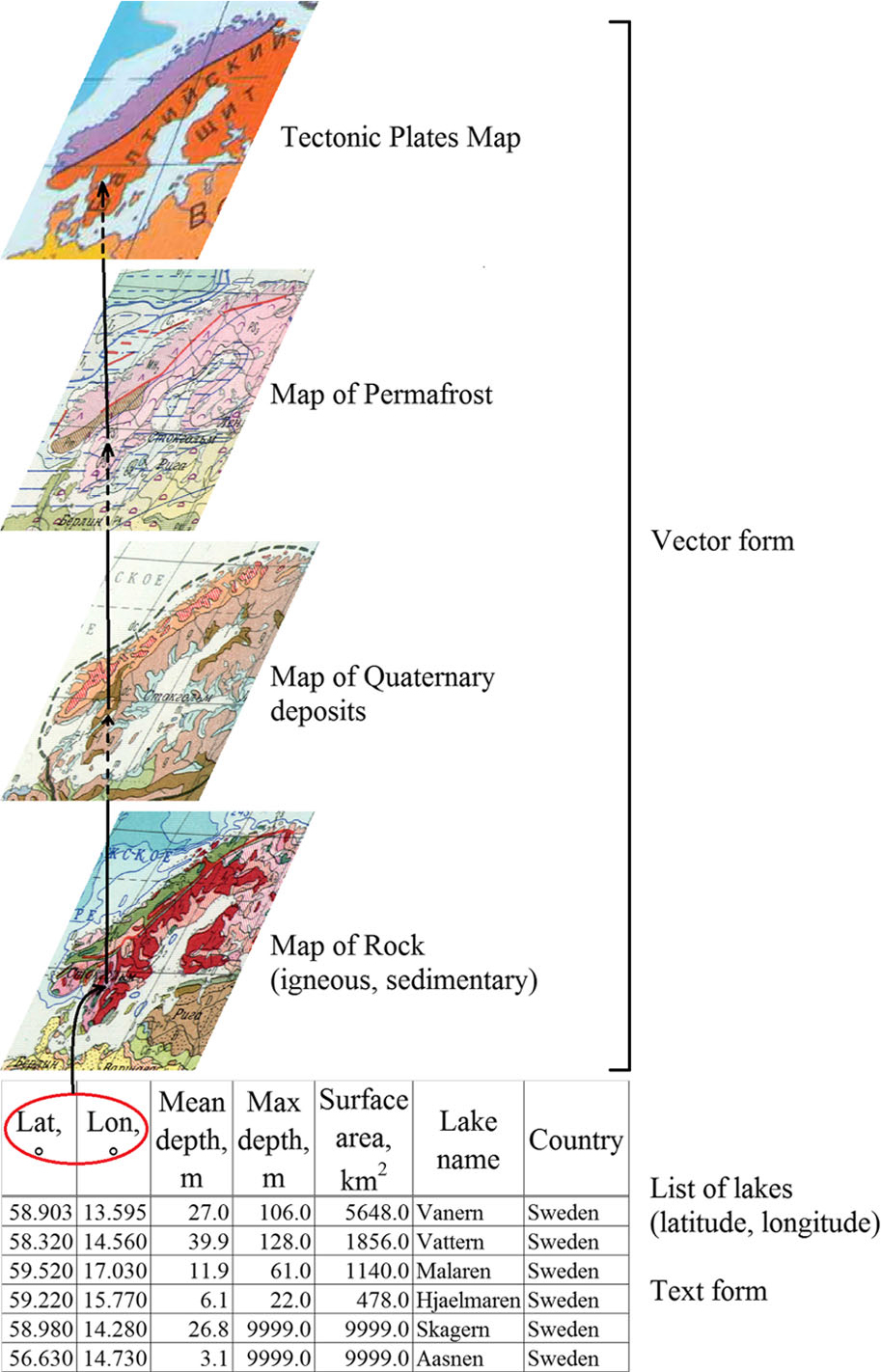
Fig. 1
Logical scheme to find existing intersections of contours from geological maps engaging data from the list of individual lakes.
Altogether, we allocated 141 regions. The list of allocated regions is presented in the Appendix. Polygons corresponding to different tectonic plates, cratons, permafrost, Quaternary deposits and rock type, were overlapped. Contours of the allocated regions were obtained by tools of geographic information systems and used further for visual analysis. Figure 2 gives an example of the allocated region: Region No. 2 from the list in the Appendix (black on the map) belongs to the group of the North American Plate, the Cadomian and Caledonian Orogenies, with igneous rocks covered by glacial Quaternary deposits, and in the region there is no permafrost.
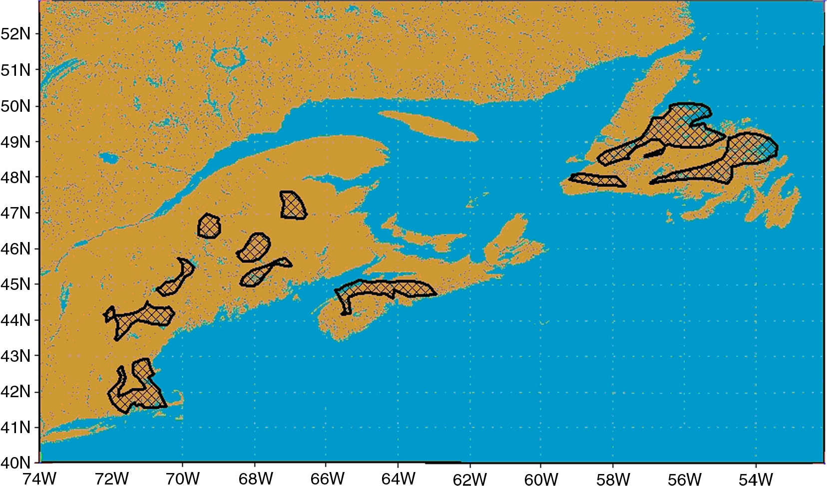
Fig. 2
Geographical location of Region No. 2 from the list in the Appendix. Region in question is marked with black on the map.
4. Evaluation of the typical lake depth
4.1. Expert evaluation based on statistical analysis
To find the typical lake depth for allocated regions, statistics from the GLDBv.1 was gained and analysed. The core of statistical analysis was building histograms of the lake depth for each region. Maximum of the histogram (the most probable value) was considered to be a guess for the typical lake depth for the region in question. Later on, starting from this guess, an expert decision about the typical lake depth was reached. Statistics were collected both from the list of individual lakes and from pixels of the gridded lake map, bearing in mind that statistics from lake pixels indirectly takes into account lake areas. Lists of lakes for each region were also compiled, as they were helpful in arriving at an expert decision.
The assumption about common geological origin of lakes in allocated regions is of course rather rigid. There could be some lakes in a region which had been formed differently from the majority of neighbouring ones. We did our best to exclude them from our analysis. For that, we performed our analysis in several steps. First, we analysed full statistics collected from the list of individual lakes and from the pixels of the gridded lake map. If there were enough data in GLDBv.1 and maximums of histograms for individual lakes and for lake pixels agreed well, the expert decision about the typical lake depth could be arrived at quite easily. Very different maximums of histograms indicated situations of non-typical large lakes located in the region. To cope with these situations, we also collected filtered statistics, with excluded large lakes, and built the appropriate histograms. For filtering, we used a criterion of the lake surface area to be more than 200 km2. This threshold value was based on practical reasons. First, the mean depth of most lakes like this is known, while measurements for smaller lakes are rather rare. Second, large lakes are often of more complex origin. They may occupy a particular geological structure that is not typical for the region. Usually they are older and have passed through the numerous cycles in their evolution. It makes them non-representative for the given statistical subset of lakes. For each of the 141 regions, four histograms were built and then analysed: for individual lakes and for lake pixels, with full data and with filtered data, making up 564 histograms in total. Statistics was collected using specially developed Fortran90 software. The expert decision about typical lake depth was reached individually for each region on the basis of the obtained statistics. Here we give some examples of expert evaluation of the typical lake depth.
The first example is Region No. 2 from the list in the Appendix displayed in Fig. 2 (the North American Plate, the Cadomian and Caledonian Orogenies, with glacial Quaternary deposits on igneous rocks, no permafrost). First, we specify how many lakes and lake pixels are in the region: here, 17 lakes and 1139 lake pixels. Second, we give a short geographical description of the region: it consists of several rather small fragments located in different parts of the Island of Newfoundland and on the seashore between the Gulf of Maine and the City of Providence. Third, we describe lakes in the region qualitatively, using the list of individual lakes for this region: here, five lakes are deeper than 10 m, four lakes are larger than 10 km2, and one lake has missing data on the lake area; small lakes (less than 3 km2) are generally dominant. The fourth step is statistical analysis, with full and filtered statistics for individual lakes and pixels of the gridded lake map (Fig. 3). A maximum of the histogram for individual lakes corresponds to the depth of 3 m, while that for lake pixels – to 50 m. This is because of a large lake which dominates in pixel statistics and which is, in fact, partly located in the neighbouring region. Since the maximums of the histograms are too far from each other, a sure decision cannot be reached on the basis of full statistics only. So we consider filtered statistics, only for lakes with the surface area less than 200 km2. There are 17 such lakes, the number of corresponding lake pixels is 417. The maximum of the histogram for individual lakes still corresponds to 3 m, but for lake pixels it changes to 7 m. Finally, the expert decision about the typical lake depth in Region No. 2 is 7 m. This is the secondary maximum of the full data histograms and the primary maximum of the filtered data lake pixel histogram.
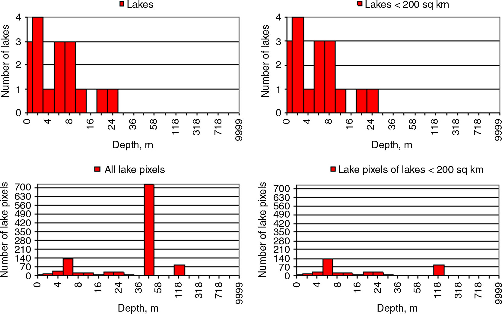
Fig. 3
Lake depth histograms for Region No. 2 from the list in the Appendix, for individual lakes (upper row), and for lake pixels on the gridded map (lower row), with full statistics (left column), and with filtered statistics, for lakes with the surface area <200 km2 (right column).
The second example is Region No. 130 from the list in the Appendix displayed in Fig. 4. It is located on the Eurasian Plate, on the Precambrian Shield, there are fluvioglacial deposits on sedimentary rocks and no permafrost. Four histograms, with full and filtered statistics, for individual lakes and lake pixels are displayed in Fig. 5. From full statistics, the maximum of the histogram for individual lakes corresponds to the depth of 7 m, but for lake pixels – of 18 m. This is probably due to a large lake, not typical for the region. Filtered statistics helped us to come to an expert decision about typical lake depth in this region of 7 m.
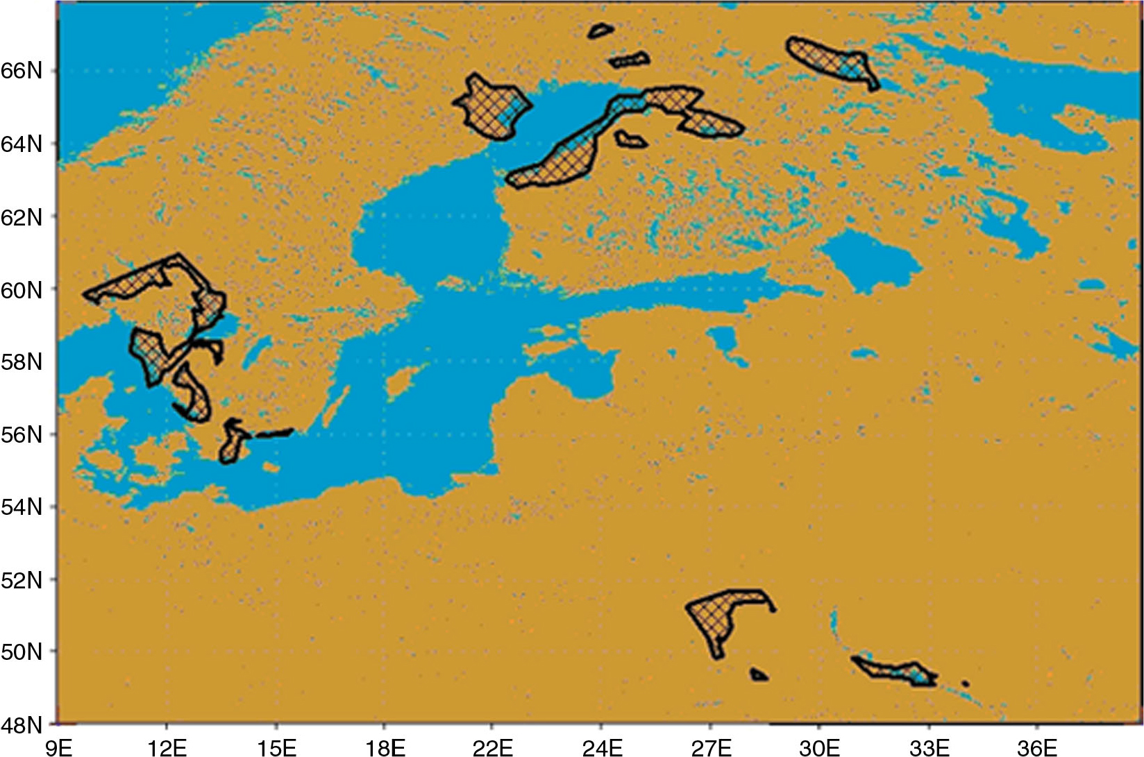
Fig. 4
Geographical location of Region No. 130 from the list in the Appendix. Region in question is marked with black on the map.
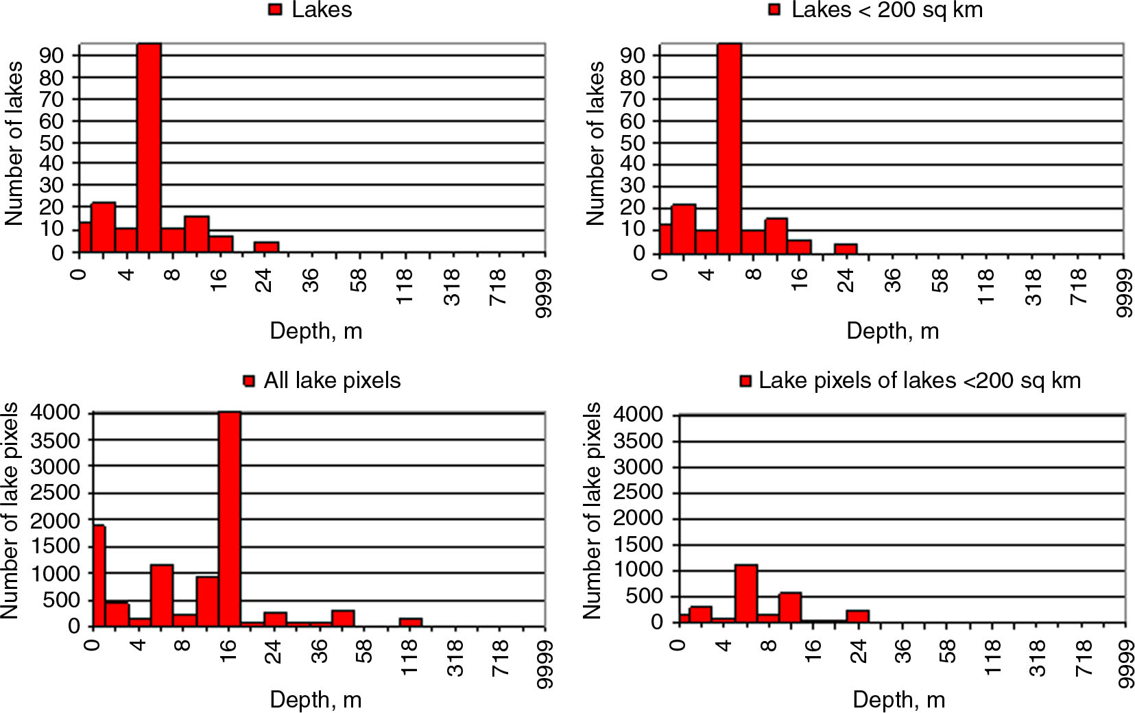
Fig. 5
Lake depth histograms for Region No. 130 from the list in the Appendix, for individual lakes (upper row), and for lake pixels on the gridded map (lower row), with full statistics (left column), and with filtered statistics, for lakes with the surface area<200 km2 (right column).
In general, statistical analysis was enough to reach a decision about the typical lake depth in a region. However, in some cases it was difficult to obtain a confident estimation on the basis of statistical analysis only; in this situation, we used the method of analogies. Also, geographical and improved geomorphologic methods were used where it was necessary and possible.
4.2. Method of analogies
We used this approach when there were no sufficient statistics about the lake depth for one region, but enough for other regions with similar geological and geomorphologic structure. The main idea of the method is extrapolation of statistics using certain geological knowledge. From this knowledge, we specified regions–analogues as follows: (i) regions with glacial, marine and fluvioglacial Quaternary deposits of one tectonic plate, (ii) cratons of one tectonic plate, (iii) Precambrian shields of different tectonic plates, (iv) orogenies of one tectonic plate. We did not combine the orogenies of one tectonic plate, but used this information to assess reliability of depth estimates.
In addition, in expert evaluation sometimes we used morphological and geographical information to consider properties of the regions (shape of lakes, elevation, surrounding vegetation, etc.). For two regions with very shallow lakes (Region No. 110 located in Southern Urals and in the north-eastern part of China and Region No. 115 located at the British and the Netherlands’ coast of the Northern Sea), we modified the typical lake depth of 1 m, given by statistical evaluation. Usually, when a lake is 1 m deep, either its bottom is visible on images or its surface in summer is covered by macrophytes. Very often, shallow lakes dry up during the summer period. From careful visual analysis of satellite images provided by Google Earth and based on Landsat and other high-resolution sensors, this was not the case for these regions. So, the typical lake depth there was estimated to be slightly larger, that is, 2 m.
4.3. Improved geomorphologic method for North East of Europe
This method (Doganovsky, 2006, 2012) was developed only for Northwest Russia and was applied here for the middle size lakes (>10 km2). This method is also based on information about geological origin of lakes. The lake volume (from which the mean lake depth may be derived) is estimated from a statistical dependency on the lake area, and this dependency is different for regions with different geological situation. To draw contours of these regions, characteristics of many known lakes with different geographical locations were analysed. Contours were drawn on the basis of knowledge about lake origin well documented for this area. Four regions were distinguished: I) region with glacial–tectonic lakes, II) lowland region with glacial–accumulative lakes, III) region with hilly–moraine glacial–accumulative lakes, IV) region with ancient glacial–accumulative lakes formed after the second glacial epoch (170–125 ka). Using the large dataset of in situ measurements of morphological parameters of lakes in Doganovsky (2012) and Doganovsky (2006), the relation between the water volume (W) and the surface area (F) was established:
where y=log10 (W+1), x=log10 (F+1), a is a parameter, dependent on the typical lake size on the territory, and m is a parameter, dependent on geological characteristics of the territory. Values of a and m for each region are given in Table 1. Therefore, from a given lake area, we can estimate the lake volume and the mean lake depth h by inverting eq. (1):
where h is given in m, and F is in km2.
We considered this method to have high reliability and gave it the highest priority on the appropriate territory. The development of this method is being continued for other territories.
4.4. Geographical approach
This method was developed by Kitaev (1984) for the boreal zone. It implies that the mutual distribution of lake parameters is specific for each geographical zone. Geographical zones of tundra, northern taiga, middle taiga and mixed forest were considered. This approach is not related to lake origin, although it may implicitly account for morphology of the territory through the dependency of vegetation on lithology of a rock or permafrost conditions. The distributions of the mean lake depth for different zones depending on the lake area are generalised and represented in Table 2. This method has very low reliability and we gave it the lowest priority. It was used for the territories where neither our statistical expert evaluations, nor improved geomorphologic method were possible. A specific case was Region No. 110 located in Southern Urals and in the north-eastern part of China (it belongs to the Eurasian Plate, sediments on the Paleozoic craton, with terrigenous deposits on sedimentary rocks without permafrost). In Southern Urals (to the north from 50° latitude), the priority was given for the geographical method: here post-permafrost lakes prevail, and the geographical method was developed especially for them.
Table 2. Lake mean depth, m, depending on lake area for different geographical zones
<1,01,934,673,905,491,0–5,03,144,834,025,675,0–10,04,964,055,485,9210,0–50,06,235,196,375,40>50,03,5010,356,216,37
The geographical zones were defined using the landscape map of SAW (1990). As legends used there and in Kitaev (1984) were different, in some cases we combined or split different landscape types to obtain better coherence. We merged together six different types of tundra landscapes, five different taiga landscape types and five mixed forest landscape types. We split taiga into northern and middle parts along a polar circle. Mountain zones were excluded.
To improve the accuracy and reliability of this method, we verified it and improved it using data from GLDBv.1. We generated analytical equations approximating statistical dependencies and used them instead of tables. For some geographical zones, we used equations based on statistics from GLDBv.1, while for others, where data in GLDBv.1 were scarce, we used data based on information from Kitaev (1984). Equations for different zones with references for data sources are given in Table 3.
Table 3. Equations for different geographical zones used in geographical method (F is the lake surface area, km2; h is the mean lake depth, m)
Tundrah=3.81·ln(F)+9.96(Kitaev, 1984)Northern taigah=4.22·e0.0112·F (Kitaev, 1984)Middle taigah=1.73·ln(F)+5.04GLDBv.1Mixed foresth=5.73·e0.0142·F GLDBv.1
For both geomorphological and geographical methods, it was necessary to know the surface area of each lake F. To obtain it, we summarised pixels of GLDBv.1 raster map for each lake, bearing in mind that a 30 arc sec. pixel area S in longitude–latitude projection is:
where 0.86 km2 is the pixel area on the Earth's equator, and ϕ is the latitude.
5. New product and discussion
Indirect estimates of the mean lake depth from their geological origin where appended to GLDBv.1 and the new raster map of the world GLDBv.2 was produced. Technically, the new map was combined from GLDBv.1 and three auxiliary maps of the world, containing the lake depth estimates from our expert evaluation, improved geomorphologic and geographical methods (see Section 4) accordingly. The additional map from GLDBv.1 containing coded information about sources of data was used for flagging and then updated. Values for pixels with code 3 (see Section 2) were just copied from the old map to a new one. For them the lake depth was measured and no indirect estimates were needed. The same was done for code 4 (river). For codes 1 and 2, we applied the following procedure: (i) if a geomorphologic method was possible, we specified the mean lake depth from it (this situation was coded by digit 7); if not, then (ii) if estimations from our expert evaluation were possible, we used them (this was coded by digit 5); if not, then (iii) if a geographical method was possible, we specified the mean lake depth from it (digit 6); if not, then (iv) we used the default depth=10 m and codes 1 or 2 accordingly. Exception from this rule was Region No. 110, for a section of it, the priority was given to the geographical method (see Section 4.4 for an explanation).
As a result, two new global raster maps were produced. The first map contains gridded information about lake depth including indirect estimates (or predictions). The second map contains information about sources of data coded with the following legend:
no lake or river (sea or land), depth=0 m
no information about this lake in the list of individual lakes, depth=10 m
missing lake depth in the list of individual lakes, depth=10 m
information about lake depth is from the list of individual lakes or bathymetry
river, depth=3 m
lake depth is estimated by our expert evaluations
lake depth is estimated by the geographical method
lake depth is estimated by the geomorphologic method.
Figures 6 and 7 give an example of the new product in comparison with the old one, for the territory close to Hudson Bay in North America. In GLDBv.1, the lake depth for unknown lakes is 10 m (code 1 on Fig. 6A and 7A). In GLDBv.2, the lake depth is smaller in the north-western part and larger in the south-western part of the region. In the south-western part (along the Gulf of St. Laurence), lakes have mostly tectonic origin, so they are supposed to be deep. This is in accordance with our estimations and modifications of the lake depth here from 10 m in GLDBv.1 to 22 m in GLDBv.2.
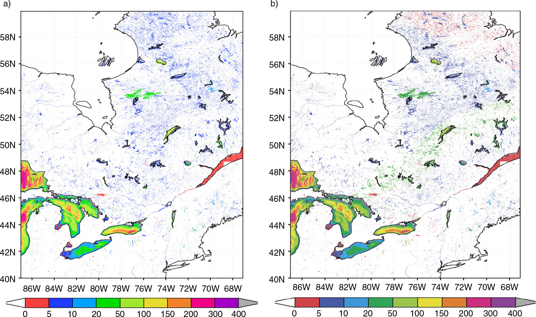
Fig. 6
Fragments of the global gridded map of lake depth, m. (a) GLDBv.1; (b) GLDBv.2.
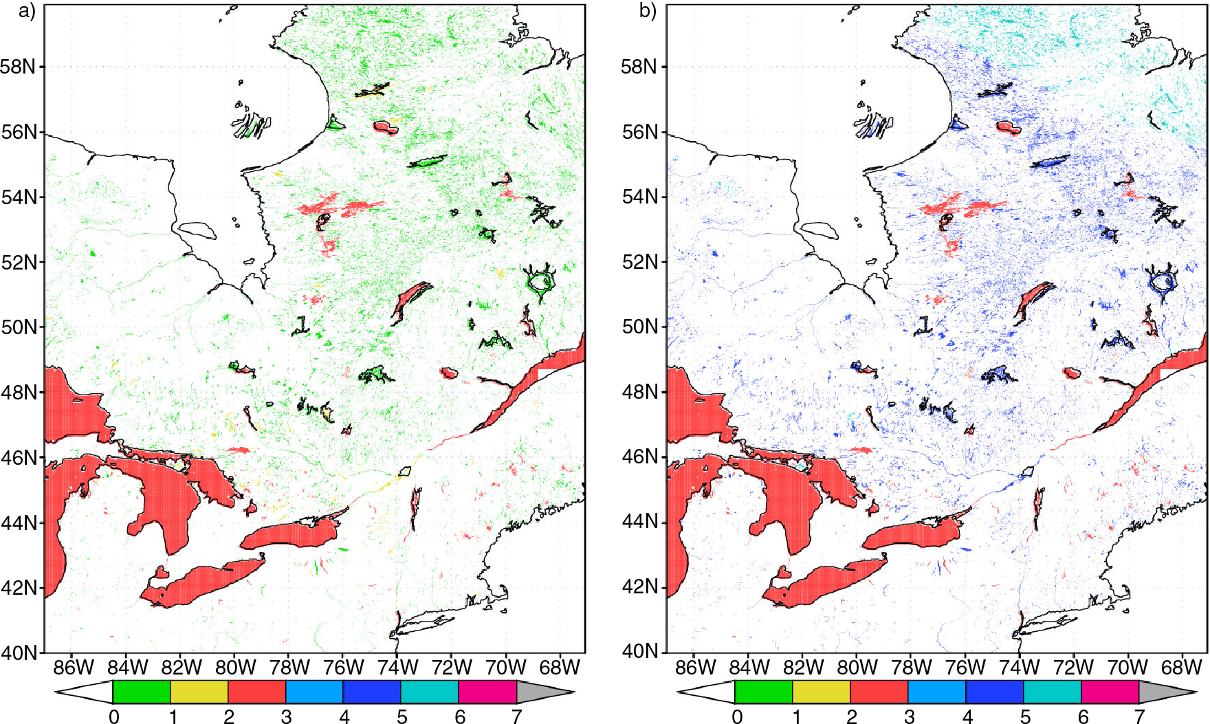
Fig. 7
Fragments of the global gridded map with coded information about origin of lake data (see legend in text, Section 5). (a) GLDBv.1; (b) GLDBv.2.
Currently, we have no additional dataset to verify or validate our product. Cross-validation is also impossible, because of data scarcity for many regions. Our estimates are noticeably subjective and basically difficult to verify. Nevertheless, we evaluated our product qualitatively, as in the example presented above. We suggest that the new version of the GLBD is more realistic as it provides physically-based estimations without contradiction to the seldom real lake depth measurements. In future, when the new data is available, validation will be performed as well as improvements being made. Another way to validate the new product is indirect. We may compare modelling results of the lake surface temperature with remote sensing observations. The main problem with this approach is errors in remote sensing data, which on the global scale may be large and should be carefully filtered out. This validation is also planned.
6. Sensitivity of the modelling results
To demonstrate the sensitivity of the modelling results to the corrections of the lake depth field, the lake model climatology (Kourzeneva et al., 2012b) was used. This climatology was developed to initialise the lake model variables in operational NWP model runs of so-called ‘cold’ start. The climatology is obtained by the 20-yr off-line runs of the two-layer bulk lake model FLake (Mironov, 2008). This model uses a self-similar representation (an assumed shape) of the temperatures profile in a lake including the mixed layer and the thermocline. The model also contains the ice module, the snow module and the bottom sediments module. The bottom sediments module was switched off in climatologic runs to save computational time and because of low sensitivity of the lake surface temperature to it. The snow module was also switched off, because it had not been yet enough validated at that moment. For atmospheric forcing, the global dataset described in Sheffield et al. (2006) was used. The product is presented on the grid in geographical coordinates (longitude and latitude) with 1° resolution. Simulations were performed for 12 hypothetic lakes with depths varying from 1 to 50 m in each grid box. Modelling results were averaged in time for 10-d intervals. The grid of a certain NWP model may have different resolution and map projection than the grid of the lake climatology product. Thus, lake information must be projected from one grid to another with the closest neighbour interpolation method. During this step, data about real lake depth on the target NWP model grid are applied, see Kourzeneva et al. (2012b) for details.
The sensitivity of the lake modelling results to modifications in GLDB is demonstrated with the climate fields of the mean water temperature, the surface water temperature and the thickness of ice for different seasons. The target grid in this example is in geographical coordinates (longitude and latitude) with a horizontal resolution of 0.02°. The domain contains part of North America with Hudson Bay where many modifications in GLDB have been done (see Figures 6 and 7). Figure 8A and Fig. 9A represent fields of the lake mean water and surface temperature for the second decade of August calculated using the new lake depth dataset. Figure 8B and 9B represent the difference, if the lake depth from GLDBv.2 and GLDBv.1 is used. Negative difference means colder temperatures with GLDBv.2; it mainly corresponds to deeper lakes. The difference both in terms of the mean water and surface temperature may reach 5°C. Ice conditions are sensitive to the modifications in GLDB mainly in autumn, since the lake depth controls an onset of the ice season. The difference between two simulations in terms of the ice thickness for the first decade of December reaches 50 sm (Fig. 10). Negative difference means less ice with GLDBv.2: many lakes, which were ice covered with the old version of GLDB, are ice-free with the new version. These lakes are deeper in GLDBv.2.
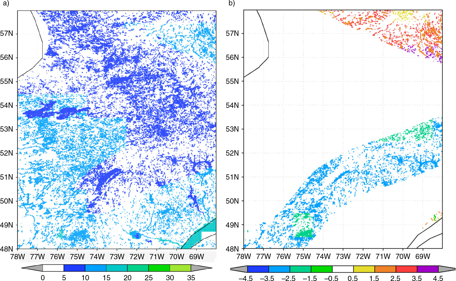
Fig. 8
Lake mean water temperature, °C, for the second decade of August, if the lake depth is extracted from GLDBv.2 (a), and the difference, if the lake depth from GLDBv.1 is used (b).
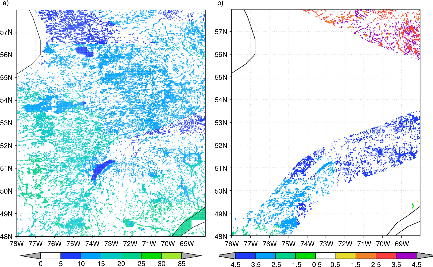
Fig. 9
Lake surface water temperature, °C, for the second decade of August, if the lake depth is extracted from: left GLDBv.2 (a), and the difference, if the lake depth from GLDBv.1 is used (b).
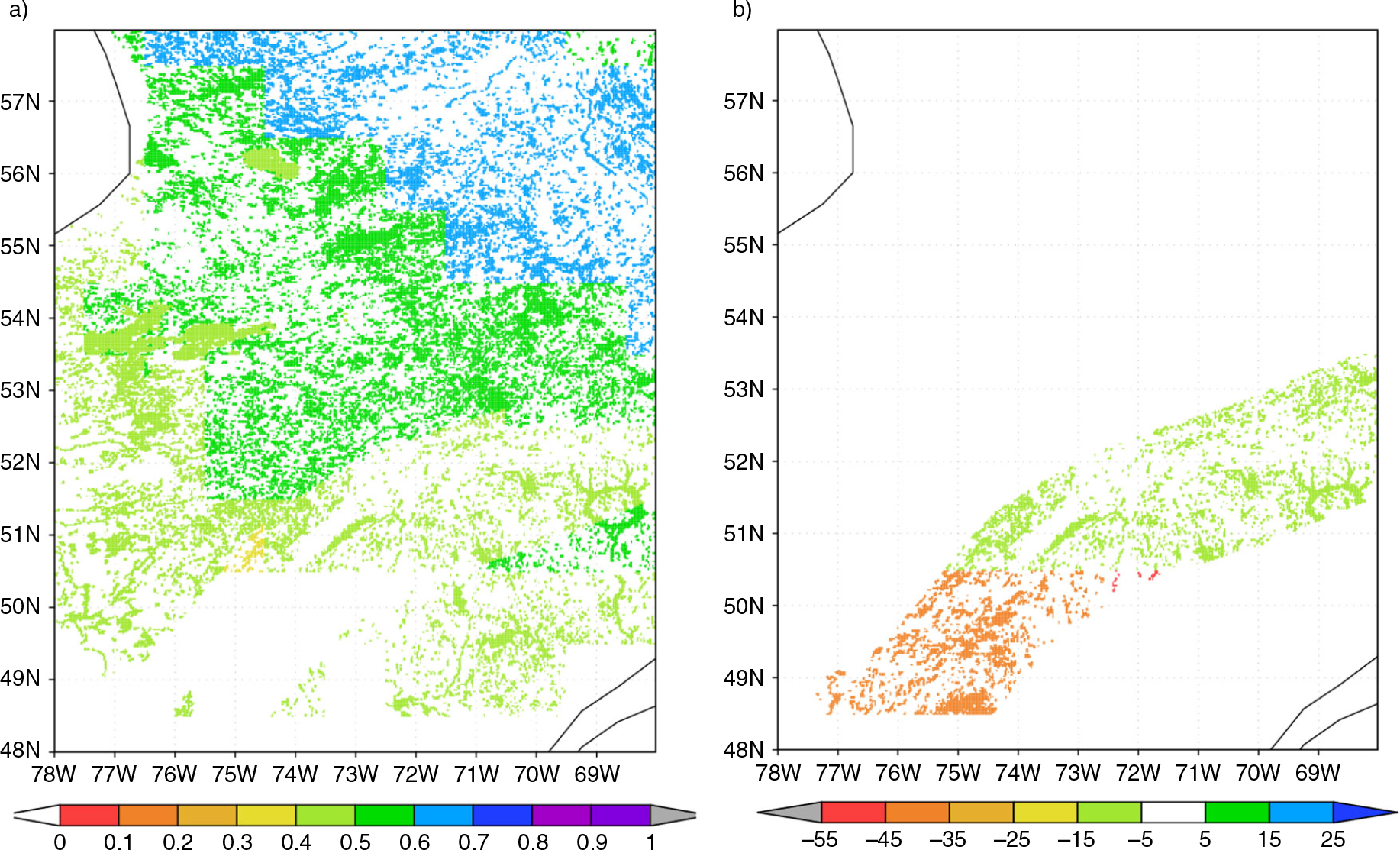
Fig. 10
Lake ice thickness, m, for the first decade of December, if the lake depth is extracted from GLDBv.2 (a) and the difference, sm, if the lake depth from GLDBv.1 is used (b).
7. Conclusion
Lakes influence local weather and the regional climate through the surface turbulent fluxes and fluxes of radiation. To parameterise them in NWP and climate modelling, external parameters are needed. The main objective of this study was to upgrade the existing GLDBv.1 (Kourzeneva et al., 2012a) by estimations (predictions) of the mean lake depth depending on their geological origin and to produce the new version of the database.
For that, we outlined the regions with similar geological and geomorphologic history suggesting similar origin of lakes there, and proposed the typical lake depths for them using expert evaluations on the basis of the statistics from the first version of the database GLDBv.1 and involving other sources of information. In addition, geomorphologic (Doganovsky, 2006) and geographical (Kitaev, 1984) methods were used where necessary and possible. We produced the new version of the database GLDBv.2, which includes estimates of the typical mean depth for the boreal lakes. Final products include the global gridded map of lake depth with the resolution of 30 arc sec. containing also indirect estimates (predictions) of the mean lake depth, and the updated list of individual lakes now containing ca. 13500 lakes.
Apart from continuous maintenance of GLDB by updating the list of individual lakes, the further developments could be proposed: (i) Extend this study and obtain the typical mean depth estimates for lakes outside boreal climate zone. (ii) Add bathymetry for more large lakes. (iii) Increase the map resolution by using different global raster maps – different ecosystem datasets.
8. Acknowledgements
The authors thank Yurii Batrak and Suleiman Mostamandi (Russian State Hydrometeorological University), as well as Pavel Andreev (North-West Interregional Territorial Department of the Federal Service for Hydrometeorology and Environmental Monitoring) for useful tips and discussions. Two anonymous reviewers made many useful comments. The project was made possible due to the support from ECMWF.
Appendices
9. Appendix
List of allocated regions with kindred geological origin of lakes and the typical mean depth h, m.
No.Type of Quaternary deposits (QD), rocks (R) and permafrost (P). Geographical description of the region.hThe North American Tectonic Plate
The Cadomian and Caledonian Orogenies 1
1Fluvioglacial QD on igneous R, no P. Rather small region on the coast of the Atlantic Ocean (near New York City)72Glacial QD on igneous R, no P. Several rather small fragments in different parts of the island of Newfoundland and on the seashore between the Gulf of Maine and Providence City73Marine QD on igneous R, no P. Small region on the seashore of the Bay of Fundy (the Nova Scotia peninsula) and the Gulf of Maine74Fluvioglacial QD on sedimentary R, no P. Rather small region, consists of several fragments on the island of Newfoundland, the Nova Scotia peninsula and the New Brunswick peninsula105Glacial QD on sedimentary R, no P. Rather big region, consists of several fragments on the coastline and far from it, on the island of Newfoundland, the Nova Scotia peninsula and the New Brunswick peninsula106Terrigenous QD on igneous R, no P. Rather small region, consists of several small fragments on the coast of the island of Newfoundland and the inland of the New Brunswick peninsula57Marine QD on sedimentary R, no P. Several fragments on the island of Anticosti in the Gulf of St. Lawrence, the northern coast of the island of Newfoundland, north-eastern and southern coasts of the New Brunswick peninsula, northern and western coasts of the Nova Scotia peninsula108Terrigenous QD on sedimentary R, no P. Several rather small fragments on the coast of the island of Newfoundland, western and southern coasts of the Gulf of St. Lawrence and the inland of the New Brunswick peninsula (Montpelier City)10The Cadomian and Caledonian Orogenies 2
9Terrigenous QD on sedimentary R, P. Large area in the middle of North-East Siberia–1The fault 1, the eastern part of the Laurentian Upland
10Glacial QD on sedimentary R, no P2211Terrigenous QD on sedimentary R, no P22The fault 3, along the Sierra Nevada and the Gulf of California
12Terrigenous QD on igneous R, no P1013Terrigenous QD on sedimentary R, no P10The fault 4, along the Coast Mountains
14Terrigenous QD on igneous R, no P5015Terrigenous QD on sedimentary R, no P50The fault 2, the northern Great Plains
16Glacial QD on sedimentary R, no P517Terrigenous QD on sedimentary R, no P.5The Hercynian Orogeny
18Glacial QD on sedimentary R, no P. Several rather small fragments near New York City and on the coasts of the Ohio River1019Terrigenous QD on igneous R, no P. Several fragments near Washington City, along the Alabama River, crossing the Savannah River (near the Atlantic coastal plain)1020Terrigenous QD on sedimentary R, P. Region in the Canadian Arctic Archipelago, the islands of Banks, Prince Patrick, Melville, Ellesmere, some are included fully, others partly2721Terrigenous QD on sedimentary R, no P. Large fragments on the north of the Canadian Arctic Archipelago (the island of Prince Patrick and the islands of Queen Elisabeth) and along the southern Appalachians till New York City10The volcanic plateau 1
22Terrigenous QD on igneous R, no P. Several small fragments in the Cascade Range area along the 120°W longitude (40–50°N)1423Marine QD on sedimentary R, no P. Rather small region on the island of Nunivak (Alaska) and the island of Vancouver–24Terrigenous QD on sedimentary R, no P. Several rather big fragments on the coast of Alaska, in the middle and southern parts of the American Cordillera27The Cimmerian and Alpine Orogenies
25Glacial QD on sedimentary R, P. Very big region, consists of several fragments with very peculiar shape, on the Oymyakon Highland, the Koryak Mountains and on the shore near it (Russia), on the northern part of the Chukchi Highland near the Chukchi Sea (Russia); on the seashore near Nome City, on the Brooks Range and the Mackenzie Mountains (Alaska)526Glacial QD on igneous R, no P. Several rather small fragments on the coast of the Alaska peninsula, the Alaska Range, and the Mackenzie Mountains5027Glacial QD on sedimentary R, no P. Rather big region, several fragments on the coast and inland of the Alaska peninsula, the Alaska Range, the Mackenzie Mountains and the northern part of the Rocky Mountains528Terrigenous QD on igneous R, no P. Numerous small fragments on the Aleutian Islands, the Alaska peninsula, the Selwyn Mountains, the Coast Mountains, the Sierra Nevada and near Phoenix City5029Terrigenous QD on sedimentary R, P. Several big fragments in Alaska till the Mackenzie mountains, the Kamchatka peninsula, the Koryak Mountains, the Yukagir Plateau, the northern part of the CentralPlateau till the Dzhugdzhur Mountains–30Marine QD on sedimentary R, no P. Rather small region on the island of Vancouver and near it3331Terrigenous QD on sedimentary R, no P. Huge region, several big and small fragments on the Aleutian islands, the Alaska peninsula, the Alaska Range, the Alexander Archipelago, along the Rocky Mountains and on the coast of the Kamchatka peninsula27Sediments on the Mesozoic Craton
32Terrigenous QD on sedimentary R, P. Rather big region, fragments on the Lena River, the Yano-Indigirka Lowland, the Kolyma Lowland till the Yukagir Plateau, Ayon Island–Sediments on the Paleozoic Craton 1
33Glacial QD on sedimentary R, no P. Rather small region along the coast of New York city till Philadelphia City534Terrigenous QD on igneous R, no P. Several rather small fragments from Philadelphia City along the Appalachians1035Terrigenous QD on sedimentary R, no P. Huge region from New York City along the Appalachians to the south-east and south till the Sacramento Mountains, the Gulf of Mexico10Sediments on the Paleozoic Craton 2
36Terrigenous QD on sedimentary R, P. Several rather big fragments near Barrow City and the Queen Elizabeth Islands–Sediments on the Precambrian Craton
37Glacial QD on sedimentary R, P. Several rather big fragments near the Mackenzie River, Banks Island and Victoria Island, the northern part of the Boothia peninsula, the northern part of Baffin Island, some parts of the Hudson Bay's coast–38Glacial QD on igneous R, no P. Two rather small fragments in State of Wisconsin near Lake Michigan, and in State of New York near the Hudson River and Lake Ontario1039Fluvioglacial QD on sedimentary R, no P. Several rather small fragments near Lakes Manitoba, Superior, Michigan, Huron340Glacial QD on sedimentary R, no P. Several big and small fragments in the Great Plains, along the Appalachians, State of Ontario, the Hudson Bay's coast541Terrigenous QD on igneous R, no P. Several rather small fragments between the Rivers of Colorado and Rio Grande, along the Sangre de Cristo Range, between the Mississippi River and Lake Superior, coasts of the River Hudson1042Terrigenous QD on sedimentary R, P. Rather big region, several fragments near the Mackenzie River, Great Bear and Great Slave Lakes, south-western coast of the Hudson Bay, coasts of Southampton Island, parts of the Canadian Arctic Archipelago–43Terrigenous QD on sedimentary R, no P. Huge region in the central part of USA and near Great Lakes5The Precambrian Shield
44Glacial QD on sedimentary R, P. Big region, several fragments in southern part of the Canadian Arctic Archipelago, the Northwest Territories (to the east from Great Bear and Great Slave lakes) and Nunavut, north-eastern coasts of Quebec and Labrador–45Fluvioglacial QD on igneous R, no P. Rather small region between Lake Superior and Lake Michigan1046Glacial QD on igneous R, no P. Several rather small fragments on the Labrador peninsula, near the St. Lawrence River, around Lake Superior, the Athabasca River, between lakes Great Slave and Athabasca1047Marine QD on sedimentary R, P. Rather big region, several fragments on the southern coast of the Gulf of Amundsen, northern coasts of Foxe Basin, western coast of the Ungava Bay, western costs of Hudson Strait, western coast of the Hudson Bay–48Fluvioglacial QD on sedimentary R, no P. Rather small region, several fragments between lakes Superior and Michigan and the Mississippi River749Glacial QD on sedimentary R, no P. Rather big region, several fragments between the Rocky Mountains and the Hudson Bay, the centre and southern part of Quebec1050Terrigenous QD on igneous R, no P. Rather small region, several fragments on the Labrador peninsula, around Lake Superior1051Terrigenous QD on sedimentary R, P. Huge region, several rather big and small fragments in Greenland, east islands of the Canadian Arctic Archipelago, Victoria Island, Prince of Wales Island, the Boothia peninsula, near lakes Great Bear and Great Slave, northern coast of the Labrador peninsula–52Marine QD on sedimentary R, no P. Rather small region on the eastern coast of the James Bay, some fragments on the western coast of the Hudson Bay, the St. Lawrence River1053Terrigenous QD on sedimentary R, no P. Rather big region, several fragments between Lake Winnipeg and the Hudson Bay, south-eastern coast of the Hudson Bay, southern and eastern coasts of the Labrador peninsula, along the St. Lawrence River10The Eurasian Tectonic Plate
The Cadomian and Caledonian Orogenies 1
54Glacial QD on igneous R, no P. Rather small region, several fragments on the north-west of Ireland, north-east of Scotland1055Glacial QD on sedimentary R, no P. Several rather small fragments in the Northern Ireland and Scotland, on the north of Scandinavia near North Cape356Terrigenous QD on igneous R, no P. Several rather small fragments along Scandinavia, north-east of Scotland, north of Ireland2757Terrigenous QD on sedimentary R, no P. Rather big region, several fragments along Scandinavia, north of Ireland and Northern Ireland, Scotland, north of Wales and England14The Cadomian and Caledonian Orogenies 2
58Glacial QD on sedimentary R, P. Several small fragments near the Altai mountains, the Yenisey River, the Taymyr peninsula–59Terrigenous QD on igneous R, P. Rather big Region, several fragments along the Altai mountains, the Stanovoye Plateau, eastern and northern coasts of the Taymyr peninsula, northern coast of the Island of Oktyabr'skoy Revolyutsii1460Fluvioglacial QD on sedimentary R, no P. Three small fragments on the east and south of the West Siberian Plain, the Altai mountains361Terrigenous QD on igneous R, no P. Rather big region, several fragments along 50° N and near the Sea of Japan1462Terrigenous QD on sedimentary R, no P. Rather big region, several fragments along 50–60° N near Lake Baikal763Terrigenous QD on sedimentary R, no P. Rather big region, several fragments in Mongolia, near the Sea of Japan5The fault 1 is situated in Scandinavia – approximately between Norway and Sweden
64Glacial QD on igneous R, no P.765Fluvioglacial QD on sedimentary R, no P.1466Glacial QD on sedimentary R, no P.767Terrigenous QD on igneous R, no P.768Terrigenous QD on sedimentary R, no P.7The fault 2 is situated near the Volga River and the Caspian Sea
69Terrigenous QD on sedimentary R, no P.5The fault 3 is situated near the Tien Shan.
70Terrigenous QD on igneous R, no P5071Terrigenous QD on sedimentary R, no P10The Hercynian Orogeny 1
72Glacial QD on igneous R, no P. Tiny region between the rivers Elbe and Odra1073Fluvioglacial QD on sedimentary R without P. Three rather small fragments near London and near the Rhine River574Glacial QD on sedimentary R, no P. Several rather small fragments in southern parts of Ireland and Wales, near the Rhine River575Terrigenous QD on igneous R, no P. Several rather small fragments near the rivers Rhine and Elbe, the southern coast of the English Channel, south-eastern part of Ireland1876Terrigenous QD on sedimentary R, no P. Rather big region, several fragments in southern parts of Ireland, Wales and England, in Spain, northern part of the Alps, Corsica, Sardinia, near the Sea of Azov14The Hercynian Orogeny 1
77Fluvioglacial QD on sedimentary R, P. Three rather big fragments on the Taymyr peninsula, the Altai Mountains, on south-western coast of the Kara Sea–78Glacial QD on sedimentary R, P. Two big fragments on south-western coast of the Kara Sea, the Taymyr peninsula–79Terrigenous QD on igneous R, P. Several rather small fragments along 50° N from the Altai mountains till Strait of Tartary, in the northern part of the Urals1880Fluvioglacial QD on sedimentary R, no P. Rather small region, several fragments in the western part of the West Siberian Plain, in the north-western part of the Altai Mountains381Terrigenous QD on igneous R, no P. Numerous small fragments along the Urals, near the Tien Shan, the Mongolian Altai Mountains, the Sikhote-Alin, on the coast of the Sea of Japan382Terrigenous QD on sedimentary R, P. Several rather big fragments all over the Asia: Novaya Zemlya, the Urals, the Taymyr peninsula, along 50° N from the Altai Mountains till Strait of Tartary783Terrigenous QD on sedimentary R, no P. Several rather big fragments on the cost of the Sea of Azov, in the southern part of the Urals, along 40–50° N from the Tien Shan till Strait of Tartary5The intercontinental rift 1, along the line which connects the western part of the Alps with the western part of the North European Plain
84Fluvioglacial QD on sedimentary R, no P.1485Terrigenous QD on sedimentary R, no P.7The intercontinental rift 2, along Lake Baikal
86Terrigenous QD on igneous R, P.1087Terrigenous QD on sedimentary R, P.10The volcanic plateau 1
88Glacial QD on sedimentary R, P. Two rather small fragments in north-western and northern parts of the Central Siberian Plateau5089Terrigenous QD on sedimentary R, P. Rather big region in north-western part of the Central Siberian Plateau50The volcanic plateau 2. Rather small region on the north coast of Strait of Tartary
90Terrigenous QD on igneous R, P.391Terrigenous QD on igneous R, no P.392Terrigenous QD on sedimentary R, P393Terrigenous QD on sedimentary R, no P3The Cimmerian and Alpine Orogenies 1
94Terrigenous QD on igneous R, no P. Rather small region, several fragments in the Caucasus between the Black and Caspian seas1495Marine QD on sedimentary R, no P. Rather small region, several fragments on the western and eastern coasts of the Caspian Sea596Terrigenous QD on sedimentary R, no P. Rather big region, several fragments in the Pyrenees, the Alps, the Apennines, from the Adriatic Sea to the Black Sea, southern and eastern coasts of the Black Sea, the Caucasus22The Cimmerian and Alpine Orogenies 2
97Terrigenous QD on igneous R, P. Several rather small fragments in the Dzhugdzhur Mountains, the Sikhote-Alin398Terrigenous QD on igneous R, no P. Several rather small fragments in the Sikhote-Alin, on the eastern coast of Honshu399Terrigenous QD on sedimentary R, P. Rather small region, several fragments near Chumikan City, the Turana Range, the Sikhote-Alin, the northern part of Sakhalin–100Marine QD on sedimentary R, no P. Rather small region, several fragments on Hokkaido7101Terrigenous QD on sedimentary R, no P. Rather big region, several fragments in the Sikhote-Alin, Sakhalin, Hokkaido, Honshu10Sediments on the Paleozoic Craton 1
102Fluvioglacial QD on sedimentary R, P. Rather big region, several fragments near the Pechora River, northern part of the Urals, the Ob River, near Salekhard City, in the middle of the West Siberian Plain, on the north of the Central Siberian Plateau–103Glacial QD on sedimentary R, P. Big region, several fragments along 65–75° N from the Kanin peninsula till the Taymyr peninsula–104Fluvioglacial QD on igneous R, no P. Small region, several fragments in the south-eastern part of the West Siberian Plain and near the Ishim River5105Glacial QD on igneous R, P. Rather small region near Salekhard City (the northern part of the Urals)70106Marine QD on sedimentary R, P. Rather small region, several fragments in the Kanin peninsular, Kolguyev Island, southern coast of the Pechora Sea, the Yamal peninsula, the Gydan peninsula, the Anabar Bay–107Fluvioglacial QD on sedimentary R, no P. Rather big region, several fragments in the Caucasus, between the Timan Ridge and the Urals, the southern part of the West Siberian Plain3108Terrigenous QD on igneous R, no P. Several small fragments all along from the Caspian Sea till Strait of Tartary, along 40–60° N5109Terrigenous QD on sedimentary R, P. Rather big region, several fragments in the Kanin peninsula, Kolguyev Island, the Pechora River, between the rivers Angara and Yenisey, northern part of the West Siberian Plain–110Terrigenous QD on sedimentary R, no P. Several big fragments in the Turan Lowland, along and on the west of the Urals, between the Black and Caspian Seas, near the Amur River1Sediments on the Paleozoic Craton 2
111Glacial QD on igneous R, no P. Very small region near Berlin City – between the rivers Elbe and Odra10112Fluvioglacial QD on sedimentary R, no P. Rather small region, several fragments near London City, the rivers Rhine, Elbe, Odra, Vistula, Bornholm Island (the Baltic Sea), the Kuban River near the Black Sea33113Glacial QD on sedimentary R, no P. Big region, several fragments in the northern part of England, near the rivers Rhine, Elbe, Odra, Vistula3114Terrigenous QD on igneous R, no P. Two small fragments on the southern coast of the English Channel, near the Elbe River10115Marine QD on sedimentary R, no P. Rather small region, several fragments near London City, Amsterdam City and Rotterdam City – near the Rhine River1116Terrigenous QD on sedimentary R, no P. Rather big region, several fragments on the coast of Portugal, the Pyrenees, the Serrania de Cuenca, coast of England, France, near the rivers Rhine, Elbe, Odra, Vistula, south-western coast of the Adriatic Sea, near the Black Sea and the Sea of Azov5Sediments on the Precambrian Craton 1
117Fluvioglacial QD on sedimentary R, no P. Rather big region, several fragments on the Oland Island, near the rivers Vistula, Nyoman, Daugava, Dnieper, Volga, Don, near Solikamsk City3118Glacial QD on sedimentary R, no P. Rather big region, several fragments near the rivers Vistula, Nyoman, Daugava, Dnieper, near Lake Onega, the Timan Ridge, the Gotland Island and the Jutland peninsula3119Marine QD on sedimentary R, no P. Several small fragments in the Caspian Lowland, on the coasts of the Baltic and White Seas1120Terrigenous QD on sedimentary R, no P. Big region, several fragments all along the territory between the Carpathians and the Urals, the Jutland peninsula, the Taklimakan Desert5Sediments on the Precambrian Craton 2
121Terrigenous QD on igneous R, P. Small region, several fragments all aver the Central Siberian Plateau, the Dzhugdzhur Mountains5122Terrigenous QD on sedimentary R, P. Big region situated on the Central Siberian Plateau, along the Lena River–123Terrigenous QD on sedimentary R, no P. Several rather small fragments on the Central Siberian Plateau5The Precambrian Shield 2
124Glacial QD on sedimentary R, P. Rather small region on the Kola peninsula till North Cape7125Fluvioglacial QD on igneous R, no P. Rather small region, several fragments in lowlands of Sweden, the north-eastern coast of the Gulf of Bothnia, near Kiev City7126Glacial QD on igneous R, no P. Rather big region, several fragments all over Sweden, Finland, Russia near the border with Finland, near Kiev City7127Glacial QD on igneous R, P. Very small region, several fragments on the Cola peninsula7128Terrigenous QD on igneous R, P. Rather small region, several fragments on the north coast of the Cola peninsula7129Marine QD on igneous R, no P. Rather small region, several fragments on the eastern coast of the White Sea7130Fluvioglacial QD on sedimentary R, no P. Rather small region, several fragments on Finnish coasts of the Baltic Sea, coasts of the Gulf of Bothnia, near the Dnieper River7131Glacial QD on sedimentary R, no P. Big region, several fragments on the coasts of Sweden, between the Gulf of Bothnia and the White Sea7132Terrigenous QD on igneous R, no P. Several rather small fragments all over Sweden, on the northern coast of the Gulf of Finland, near lakes Ladoga and Onega, near Kiev City7133Terrigenous QD on sedimentary R, P. Rather small region, several fragments on the Cola peninsula7134Marine QD on sedimentary R, no P. Rather small region, several fragments on the western coast of the White Sea7135Terrigenous QD on sedimentary R, no P. Rather small region, several fragments along southern and eastern coasts of Sweden, near the White Sea, near lakes Ladoga and Onega, Vanern and Vattern7Iceland2
136Fluvioglacial QD on sedimentary R, P. Two rather small fragments on the north-eastern and southern parts of Iceland5137Glacial QD on sedimentary R, P. Several fragments in the northern, eastern and southern parts of Iceland5138Fluvioglacial QD on igneous R, P. Rather small region, several fragments in the south-west of Iceland7139Glacial QD on igneous R, P. Rather small region, several fragments on the south-western and north-eastern coasts of Iceland7140Terrigenous QD on igneous R, P. Rather small fragments all over Iceland3141Terrigenous QD on sedimentary R, P. Rather small region, several fragments in the centre and on the coasts of Iceland5