
Fig. 1

Fig. 2

Fig. 3

Fig. 4

Fig. 5

Fig. 6

Fig. 7

Fig. 8
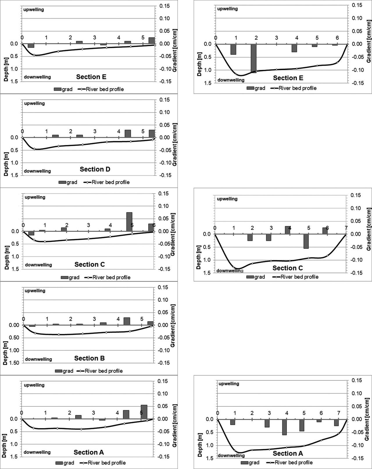
Fig. 9

Fig. 10

Fig. 11

Fig. 12

Hydrological variation in the Moszczenica catchment (based on Jokiel 2004)_
| Section of Moszczenica | Total runoff | Groundwater runoff | Share of groundwater runoff in the total runoff | Specific total runoff | Specific groundwater runoff | Share of specific groundwater runoff in the specific total runoff |
|---|---|---|---|---|---|---|
| [dm3 · s−1 · km−2] | [%] | [dm3 · s−1 · km−2] | [%] | |||
| Upper | 4–5 | 3–4 | 60–70 | 6.1–7.0 | 3.6–4.0 | >60 |
| Middle | 4–5 | 2–3 | 50–60 | 5.1–6.0 | 3.1–3.5 | 56–60 |
| Lower | 3–4 | <2 | 40–50 | 4.1–5.0 | 2.6–3.0 | 51–55 |
Characteristic water level and flow of the Moszczenica River measured in the gauging station in Gieczno in 1971–1990 (after Szczepański 1995)_
| Water level [cm] | |
| Extremely high stage | 316 |
| Extremely low stage | 120 |
| Flow [m3 · s−1] | |
| Extremely high flow | 9.42 |
| Medium high flow | 4.72 |
| Medium mean flow | 0.92 |
| Medium low flow | 0.29 |
| Extremely low flow | 0.17 |
Water levels in the riverbed, water table in observation wells and hydraulic gradients in the Moszczenica bottom in upwelling zones_
| Date | Hr | No. 6 | No. 3 | ΔL [m] | 875 | ΔR [m] | 432 |
|---|---|---|---|---|---|---|---|
| Δ (No. 6 – Hr) | Grad L | Δ (No. 3 – Hr) | Grad R | ||||
| [m a.s.l.] | [m] | [−] | [m] | [−] | |||
| Oct-15 | 114.94 | 116.78 | 115.95 | 1.84 | 0.0021 | 1.01 | 0.0023 |
| Nov-15 | 114.96 | 116.88 | 115.87 | 1.92 | 0.0022 | 0.91 | 0.0021 |
| Dec-15 | 114.99 | 117.16 | 116.10 | 2.18 | 0.0025 | 1.12 | 0.0026 |
| Jan-16 | 115.09 | 117.20 | 116.07 | 2.11 | 0.0024 | 0.98 | 0.0023 |
| Feb-16 | 115.01 | 117.26 | 116.13 | 2.25 | 0.0026 | 1.12 | 0.0026 |
| Apr-16 | 115.08 | 117.70 | 116.43 | 2.62 | 0.0030 | 1.35 | 0.0031 |
| May-16 | 114.94 | 117.30 | 116.33 | 2.36 | 0.0027 | 1.39 | 0.0032 |
| Jun-16 | 114.91 | 117.50 | 116.27 | 2.59 | 0.0030 | 1.36 | 0.0031 |
| Jul-16 | 114.92 | 117.10 | 116.17 | 2.18 | 0.0025 | 1.25 | 0.0029 |
| Aug-16 | 114.89 | 117.20 | 116.10 | 2.31 | 0.0026 | 1.21 | 0.0028 |
| Sep-16 | 114.87 | 117.15 | 115.77 | 2.28 | 0.0026 | 0.90 | 0.0021 |
| Oct-16 | 114.98 | 117.20 | 116.12 | 2.22 | 0.0025 | 1.15 | 0.0027 |
| Nov-16 | 115.15 | 117.28 | 116.40 | 2.13 | 0.0024 | 1.25 | 0.0029 |
| Feb-17 | 115.30 | 117.50 | 116.61 | 2.21 | 0.0025 | 1.32 | 0.0030 |
| Apr-17 | 115.00 | 117.26 | 116.72 | 2.26 | 0.0026 | 1.72 | 0.0040 |
| May-17 | 114.94 | 117.10 | 116.94 | 2.16 | 0.0025 | 2.00 | 0.0046 |
| Jun-17 | 114.88 | 117.00 | 116.79 | 2.13 | 0.0024 | 1.92 | 0.0044 |
| Jul-17 | 114.91 | 117.08 | 116.70 | 2.17 | 0.0025 | 1.79 | 0.0041 |
| Sep-17 | 115.13 | 117.20 | 116.94 | 2.07 | 0.0024 | 1.81 | 0.0042 |
| Oct-17 | 115.12 | 117.15 | 117.00 | 2.03 | 0.0023 | 1.88 | 0.0044 |
| Dec-17 | 115.17 | 117.35 | 116.65 | 2.18 | 0.0025 | 1.48 | 0.0034 |
| Jan-18 | 115.20 | 117.60 | 116.72 | 2.40 | 0.0027 | 1.52 | 0.0035 |
| Feb-18 | 115.08 | 117.60 | 116.52 | 2.52 | 0.0029 | 1.44 | 0.0033 |
| Apr-18 | 114.98 | 117.53 | 116.58 | 2.55 | 0.0029 | 1.60 | 0.0037 |
| Jun-18 | 114.89 | 117.48 | 116.60 | 2.59 | 0.0030 | 1.71 | 0.0040 |
| Jul-18 | 114.93 | 117.40 | 116.57 | 2.47 | 0.0028 | 1.64 | 0.0038 |
| Oct-18 | 115.00 | 117.63 | 116.66 | 2.63 | 0.0030 | 1.66 | 0.0038 |
| Nov-18 | 114.97 | 117.71 | 116.64 | 2.74 | 0.0031 | 1.67 | 0.0039 |
| Dec-18 | 115.02 | 117.75 | 116.70 | 2.73 | 0.0031 | 1.68 | 0.0039 |
| 0.0026 | gradav | 0.0033 | |||||
Results of the water flow rate measurement in the canal of the Moszczenica_
| Canal | Distance | Flow | Comments |
|---|---|---|---|
| [m] | [m3 · s−1] | ||
| P1 | 0 | 1.1747 | |
| P2 | 92 | 1.0654 | In front of the ditch |
| P3 | 88 | 1.1795 | Behind the pond |
| P4 | 80 | 1.2264 |
Granulometric and hydraulic characteristics of the Moszczenica riverbed sediments_
| Parameters | P1 | P4 | P9 | |||
|---|---|---|---|---|---|---|
| Fractions | ||||||
| Gravel % (10–2 mm) | 5.70 | 1.26 | 24.45 | 2.64 | 49.37 | 0.46 |
| Sand % (2–0.1 mm) | 85.78 | 65.48 | 77.43 | 76.29 | 44.06 | 34.30 |
| Silt % (0.1–0.01 mm) | 8.43 | 29.95 | 6.14 | 20.72 | 6.36 | 62.76 |
| Loam % (< 0.01 mm) | 0.09 | 3.30 | 2.13 | 0.35 | 0.22 | 2.48 |
| Equivalent grain diameters and grain distribution unevenness index | ||||||
| d10 [mm] | 0.055 | 0.013 | 0.088 | 0.023 | 0.079 | 0.013 |
| d20 [mm] | 0.086 | 0.024 | 0.130 | 0.048 | 0.140 | 0.016 |
| d60 [mm] | 0.210 | 0.120 | 0.370 | 0.140 | 2.300 | 0.044 |
| Hydraulic conductivity | ||||||
| U | 3.82 | 9.23 | 4.21 | 6.09 | 29.11 | 3.39 |
| k10 [m · s−1] | 1.28 · 10−3 | 6.77 · 10−5 | 3.30 · 10−3 | 3.34 · 10−4 | 3.91 · 10−3 | 2.67 · 10−5 |
Analysis of the hydraulic gradient results in the Moszczenica bottom at different water levels_
| Parameter | Low water level | High water level | ||
|---|---|---|---|---|
| A B C D E | A C E | |||
| Upwelling | Downwelling | Upwelling | Downwelling | |
| Maximum | 0.075 | −0.000 | 0.030 | −0.000 |
| Minimum | 0.000 | −0.015 | 0.000 | −0.110 |
| Average | 0.016 | −0.008 | 0.018 | −0.027 |
| Median | 0.010 | −0.005 | 0.025 | −0.025 |
| Number | 27 | 6 | 3 | 18 |
| Share | 81.8% | 18.2% | 14.3% | 85.7% |
Statistical analysis of the results of the hydraulic gradient research in the bottom of the Moszczenica for the canal, transitional zone and the natural riverbed_
| Parameter | Artificial canal | Transition zone | Natural riverbed | Together | ||||
|---|---|---|---|---|---|---|---|---|
| P1–P5 | P6–P8 | P9–P13 | P1–P13 | |||||
| Upwelling | Downwelling | Upwelling | Downwelling | Upwelling | Downwelling | Upwelling | Downwelling | |
| Maximum | 0.005 | −0.000 | 0.045 | −0.000 | 0.055 | −0.000 | 0.055 | −0.000 |
| Minimum | 0.000 | −0.085 | 0.000 | −0.040 | 0.000 | −0.065 | 0.000 | −0.085 |
| Average | 0.003 | −0.029 | 0.018 | −0.025 | 0.023 | −0.023 | 0.019 | −0.027 |
| Median | 0.005 | −0.020 | 0.020 | −0.030 | 0.023 | −0.015 | 0.018 | −0.020 |
| Number | 3 | 15 | 7 | 4 | 12 | 5 | 22 | 24 |
| Share [%] | 16.7 | 83.3 | 63.6 | 36.4 | 70.6 | 29.4 | 47.8 | 52.2 |