
Table 1
Population and population density in communes.
| No. | Commune | [1] Population on 31.Dec.1998 | [2] Population on 31.Dec.2008 | [3] Population on 31.Dec.2018 | [4] Population change in years 1998–2018 | [5] Population density. Population per 1 km2 on 31.Dec.2008 | [6] Population density. Population per 1 km2 on 31.Dec.2018 | [7] Data difference. Change in population density (people per 1 km2) in years 2008–2018 |
|---|---|---|---|---|---|---|---|---|
| 1 | Żukowo | 14,771 | 21,337 | 32,368 | 17,597 | 134 | 203 | 69 |
| 2 | Kolbudy | 8,191 | 13,147 | 17,417 | 9,226 | 159 | 211 | 52 |
| 3 | Pruszcz Gdański | 14,021 | 18,592 | 30,232 | 16,211 | 129 | 210 | 81 |
| 4 | Cedry Wielkie | 6,044 | 6,347 | 6,947 | 903 | 51 | 56 | 5 |
| 5 | Stegna | 9,709 | 9,622 | 9,779 | 70 | 57 | 57 | 0 |
Table 2
State of the population in the villages.
| No. | Commune | Region | Village | [1] Population on 31.Dec.2008 (data from 1. Jan. 2009) | [2] Population on 31. Dec. 2018 | [3] Difference Population change from 2008 to 2018 |
|---|---|---|---|---|---|---|
| 1 | Żukowo | Kashubian Villages | Chwaszczyno | 2,937 | 3,781 | 844 |
| 2 | Nowy Świat | – | 319 | – | ||
| 3 | Rębiechowo | 561 | 847 | 286 | ||
| 4 | banino | 2,395 | 6,903 | 4,508 | ||
| 5 | Czaple | 329 | 641 | 312 | ||
| 6 | Leźno | 1,450 | 1,688 | 238 | ||
| 7 | Sulmin | 469 | 563 | 94 | ||
| 8 | Kolbudy | Otomin | 631 | 973 | 342 | |
| 9 | Kowale | 2,535 | 4,161 | 1,626 | ||
| 10 | Jankowo Gdańskie | 518 | 846 | 328 | ||
| 11 | Pruszcz Gdański | Borkowo | 829 | 4,159** | 3,330 | |
| 12 | Straszyn | 5,738 3,057* | 5,156** | 2,099 | ||
| 13 | Rotmanka | lack of data 2,255* | 3,229** | 974 | ||
| 14 | Żuławy Villages | Mokry Dwór | 214 | 213** | −1 | |
| 15 | Krępiec | 102 | 103** | 1 | ||
| 16 | Dziewięć Włók | 140 | 145** | 5 | ||
| 17 | Przejazdowo | 637 | 643** | 6 | ||
| 18 | Bogatka | 150 | 172** | 22 | ||
| 19 | Wiślinka | 1,130 | 1,268** | 138 | ||
| 20 | Cedry Wielkie | Trzcinisko | 210 | 187 | −23 | |
| 21 | Stegna | Żuławki | 612 | 450 | −162 | |
| 22 | Drewnica | 947 | 879 | −68 | ||
| 23 | Mikoszewo | 765 | 741 | −24 |
* – represents data for Straszyn and Rotmanka (Public Information Bulletin of Pruszcz Gdański Commune Office 2008).
The 2008 data for Straszyn obtained from the Universal Electronic Population Register System (Polish – PESEL) seems doubtful (5,738 persons). In this case, the 2002 population figures available on the website of the commune of Pruszcz Gdański have been taken into account.
Table 3
Number of apartments handed over for use in the years 2008–2017.
| No. | Commune | Region | Village | [1] 2008 [I+S/R+T] | [2] 2009 | [3] 2010 | [4] 2011 | [5] 2012 | [6] 2013 | [7] 2014 | [8] 2015 | [9] 2016 | [10] 2017 | [11] Total from years 2008–2017 |
|---|---|---|---|---|---|---|---|---|---|---|---|---|---|---|
| 1 | Żukowo | Kashubian villages | Chwaszczyno | [28+0] 28 | [21+0] 21 | [34+63] 97 | [40+2] 42 | [55+11] 66 | [37+3] 40 | [37+0] 37 | [18+4] 22 | [38+9] 47 | [23+7] 30 | [331+99] 430 |
| 2 | Nowy Świat | – | – | – | – | – | – | – | – | – | – | – | ||
| 3 | Rębiechowo | [7+0] 7 | [12+0] 12 | [22+0] 22 | [19+0] 19 | [8+0] 8 | [14+0] 14 | [6+0] 6 | [6+0] 6 | [15+1] 16 | [15+0] 15 | [124+1] 125 | ||
| 4 | Banino | [53+2] 55 | [37+0] 37 | [56+16] 72 | [58+21] 79 | [81+36] 117 | [117+83] 200 | [107+76] 183 | [72+246] 318 | [67+295] 362 | [37+238] 275 | [685+1,013] 1,698 | ||
| 5 | Czaple | [3+0] 3 | [0+0] 0 | [5+0] 5 | [4+0] 4 | [11+0] 11 | [10+9] 19 | [8+5] 13 | [7+6] 13 | [6+16] 22 | [12+17] 29 | [66+53] 119 | ||
| 6 | Leźno | [4+0] 4 | [7+0] 7 | [17+0] 17 | [8+0] 8 | [15+0] 15 | [15+0] 15 | [9+0] 9 | [16+1] 17 | [16+0] 16 | [10+1] 11 | [117+2] 119 | ||
| 7 | Sulmin | [3+0] 3 | [2+0] 2 | [5+0] 5 | [5+0] 5 | [7+0] 7 | [5+0] 5 | [8+0] 8 | [3+0] 3 | [1+0] 1 | [3+0] 3 | [42+0] 42 | ||
| 8 | Kolbudy | Otomin | [17+0] 17 | [18+0] 18 | [16+0] 16 | [12+0] 12 | [16+0] 16 | [15+0] 15 | [13+1] 14 | [12+0] 12 | [11+0] 11 | [8+0] 8 | [138+1] 139 | |
| 9 | Kowale | [18+98] 116 | [15+30] 45 | [22+50] 72 | [15+40] 55 | [14+30] 44 | [13+94] 107 | [14+67] 81 | [14+114] 128 | [11+209] 220 | [8+252] 260 | [144+984] 1,128 | ||
| 10 | Jankowo Gdańskie | [11+5] 16 | [5+0] 5 | [14+1] 15 | [10+2] 12 | [10+2] 12 | [10+2] 12 | [9+10] 19 | [14+8] 22 | [8+2] 10 | [13+24] 37 | [104+56] 160 | ||
| 11 | Pruszcz Gdański | Borkowo | [22+27] 49 | [26+315] 341 | [20+109] 129 | [21+358] 379 | [16+207] 223 | [24+164] 188 | [29+60] 89 | [16+200] 216 | [22+12] 34 | [14+34] 48 | [210+1,486] 1,696 | |
| 12 | Straszyn | [78+197] 275 | [62+110] 172 | [59+101] 160 | [37+57] 94 | [95+75] 170 | [97+156] 253 | [55+74] 129 | [44+53] 97 | [47+134] 181 | [24+243] 267 | [598+1,200] 1,798 | ||
| 13 | Rotmanka | – | – | – | – | – | – | – | – | – | – | – | ||
| 14 | Pruszcz Gdański | Żuławy villages | Mokry Dwór | – | – | – | – | – | [2+0] 2 | [3+0] 3 | [2+0] 2 | – | – | – |
| 15 | Krępiec | [1+0] 1 | [0+0] 0 | [0+0] 0 | [0+0] 0 | [0+0] 0 | [0+0] 0 | [0+0] 0 | [0+0] 0 | [0+0] 0 | [1+0] 1 | [2+0] 2 | ||
| 16 | Dziewięć Włók | [1+0] 1 | [0+0] 0 | [1+1] 2 | [0+0] 0 | [1+0] 1 | [0+0] 0 | [0+0] 0 | [2+0] 2 | [1+0] 1 | [1+0] 1 | [7+1] 8 | ||
| 17 | Przejazdowo | [4+0] 4 | [1+0] 1 | [4+0] 4 | [3+0] 3 | [1+0] 1 | [3+0] 3 | [3+0] 3 | [2+0] 2 | [3+0] 3 | [3+0] 3 | [27+0] 27 | ||
| 18 | Bogatka | [1+0] 1 | [1+0] 1 | [1+0] 1 | [0+0] 0 | [0+0] 0 | [2+0] 2 | [1+0] 1 | [0+0] 0 | [0+0] 0 | [2+0] 2 | [8+0] 8 | ||
| 19 | Wiślinka | [21+0] 21 | [14+0] 14 | [12+0] 12 | [8+0] 8 | [15+0] 15 | [11+0] 11 | [9+0] 9 | [7+0] 7 | [5+0] 5 | [9+0] 9 | [111+0] 111 | ||
| 20 | Cedry Wielkie | Trzcinisko | – | – | – | – | – | – | – | – | – | [1+0] 1 | – | |
| 21 | Stegna | Żuławki | [4+0] 4 | [3+0] 3 | [3+0] 3 | [3+0] 3 | [1+0] 1 | [1+0] 1 | [2+0] 2 | [0+0] 0 | [0+0] 0 | [3+0] 3 | [20+0] 20 | |
| 22 | Drewnica | [3+0] 3 | [6+0] 6 | [2+0] 2 | [2+0] 2 | [1+0] 1 | [1+0] 1 | [2+0] 2 | [1+0] 1 | [3+0] 3 | [1+0] 1 | [22+0] 22 | ||
| 23 | Mikoszewo | [8+0] 8 | [5+0] 5 | [7+0] 7 | [10+0] 10 | [3+6] 9 | [7+0] 7 | [2+0] 2 | [5+0] 5 | [0+0] 0 | [5+1] 6 | [52+7] 59 |
[i] [1–10] – apartments handed over for use in the years 2008–2017 (Poland in figures 2017).
[iii] I – individual apartments.
[iv] S/R – apartments for sale/rental.
[v] T – total number of apartments handed over for use in particular year.
[vi] Explanation of colors:
 300 apartments and more handed over for use
 200–299 apartments
 100–199 apartments
 0 apartments
– lack of data
[vii] The term ‘apartment’ in this statistical context is understood to mean both apartment and house. The terminology used is consistent with that used by ‘Statistics Poland’.
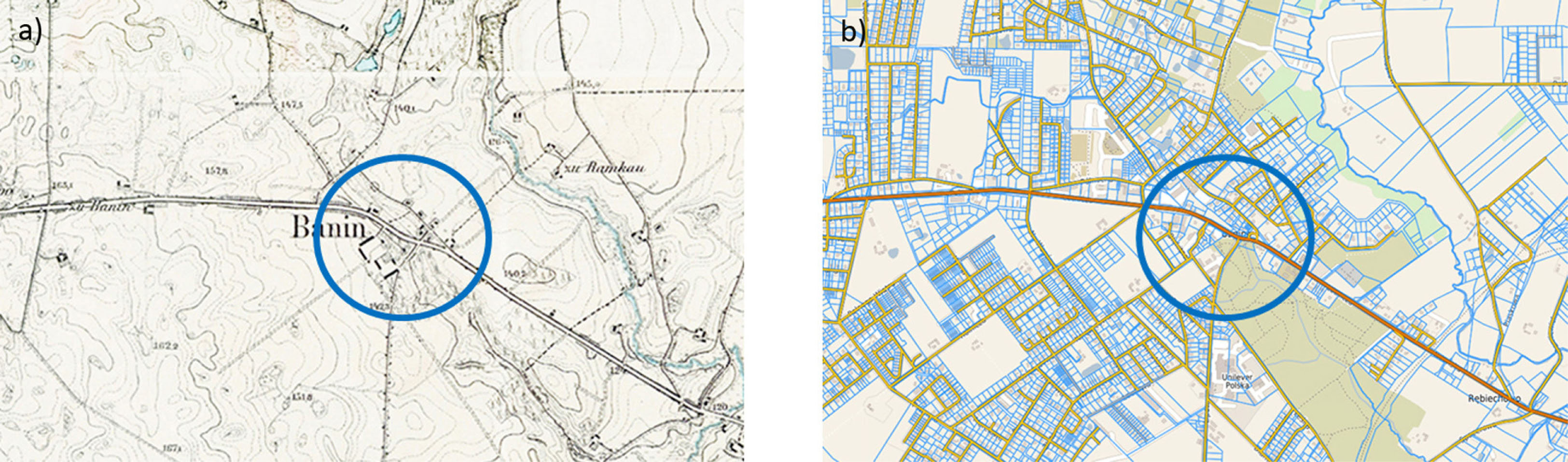
Fig. 1
Comparison of the spatial arrangement of Banino from (a) 1917 (map of Banino 1917) and (b) the contemporary one (map of Banino 2019). The blue circle indicates the oldest part of the village and the orange line indicates the main road through the village.
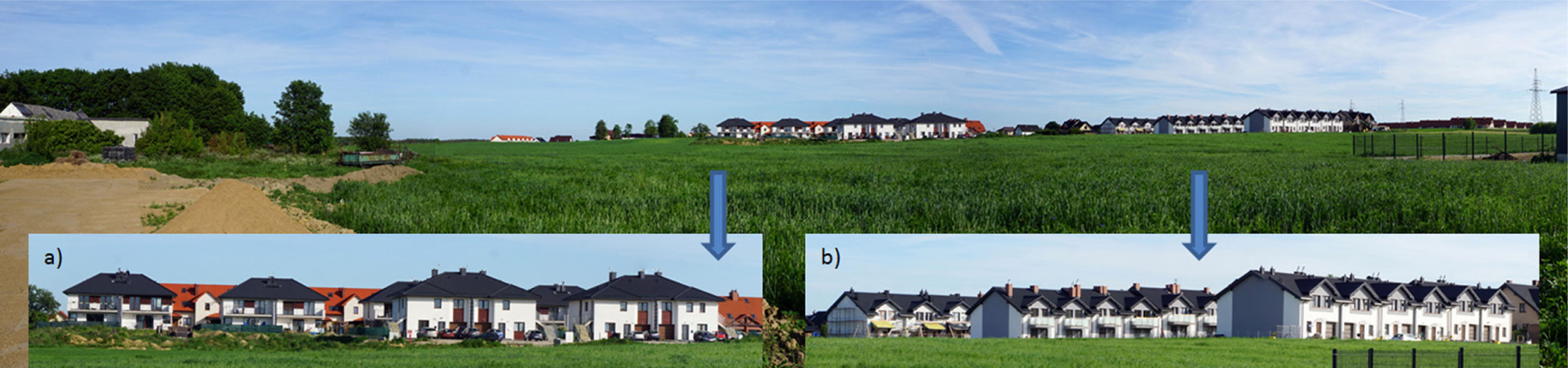
Fig. 2
Open view from the side of Lotnicza Street on the development at Halna and Rolnicza Streets: (a) a zoom on multi-family buildings and (b) a close-up on terraced houses. Buildings in the background, behind the arable field (starting from the left-hand side of the photos): farmstead, multi-family houses (behind them are single-family semi-detached houses) and terraced houses.
Photo by J. Poczobut, 2019.
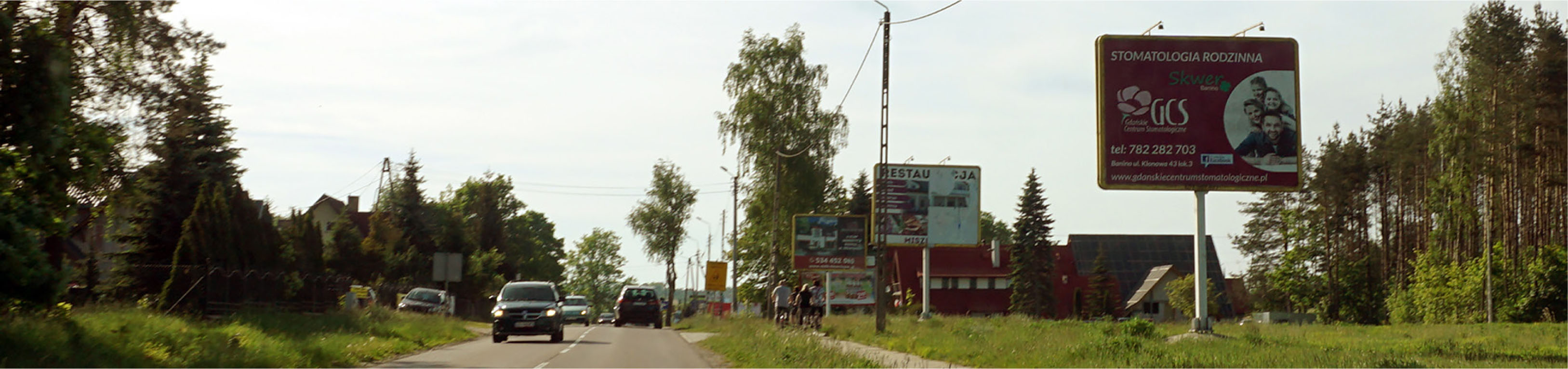
Fig. 3
Land development on the main road in Banino (Lotnicza Street). Large standing advertising banners covering the church tower – a dominant landscape of the village.
Photo by J. Poczobut, 2019.
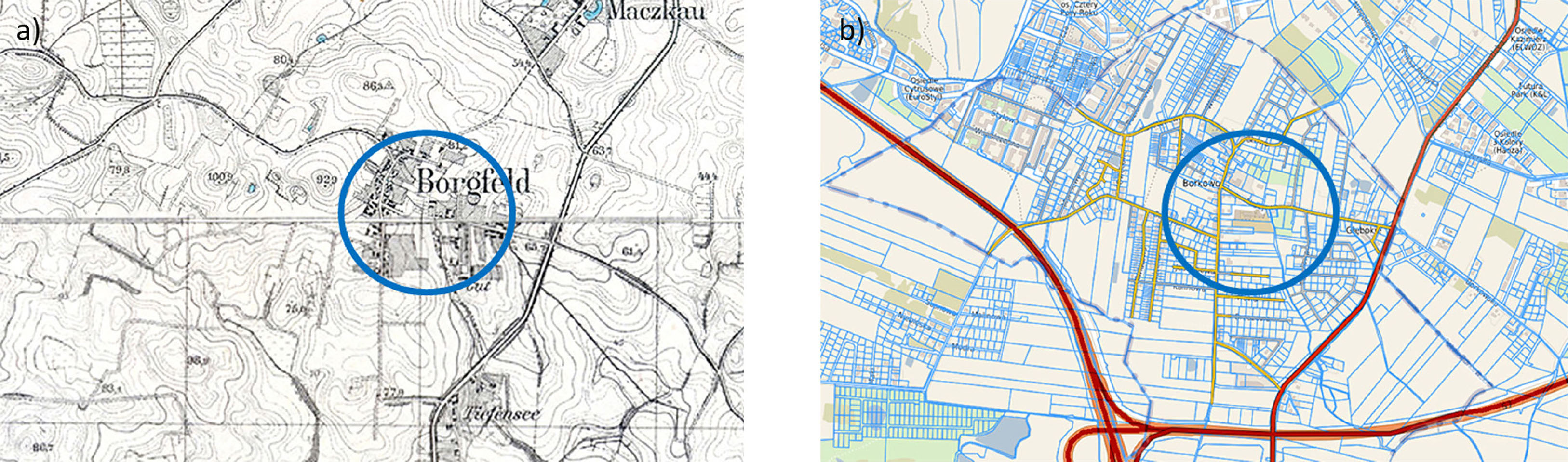
Fig. 4
Comparison of the spatial arrangement of Borkowo (a) in 1925 (map of Borkowo 1925) with (b) the contemporary one (map of Borkowo 2019). The oldest areas of the village are marked with the blue circle, the red line indicates its main road (with Tri-City ring road S6 and south road S7).
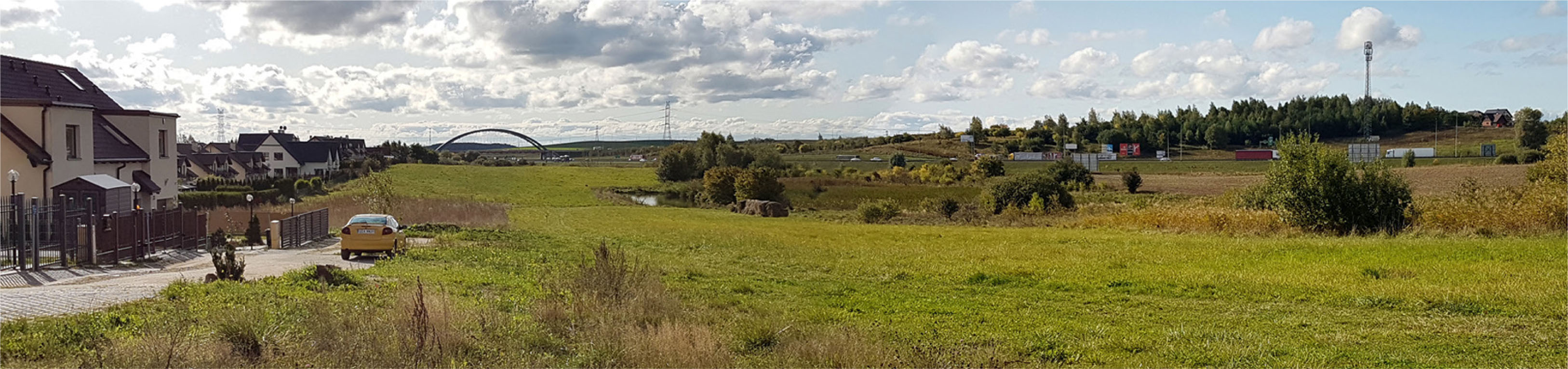
Fig. 5
Single-family semi-detached houses at Bratkowa and Kwiatowa Streets in Borkowo. Open view in the south-western direction. In the distance: construction of a bridge over Tri-City ring road S6 (communication node with south ring road S7).
Photo by J. Poczobut, 2019.
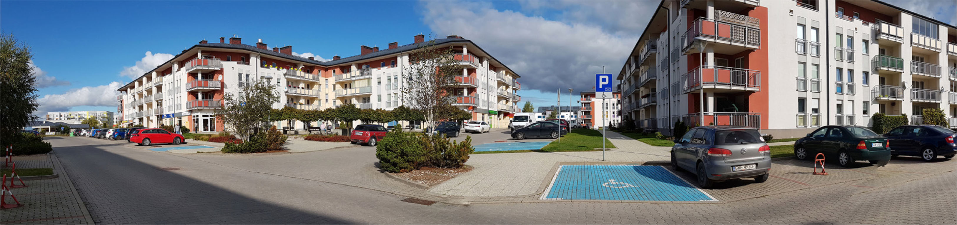
Fig. 6
Urban development of the Nowy Horyzont estate in Borkowo.
Photo by J. Poczobut, 2019.
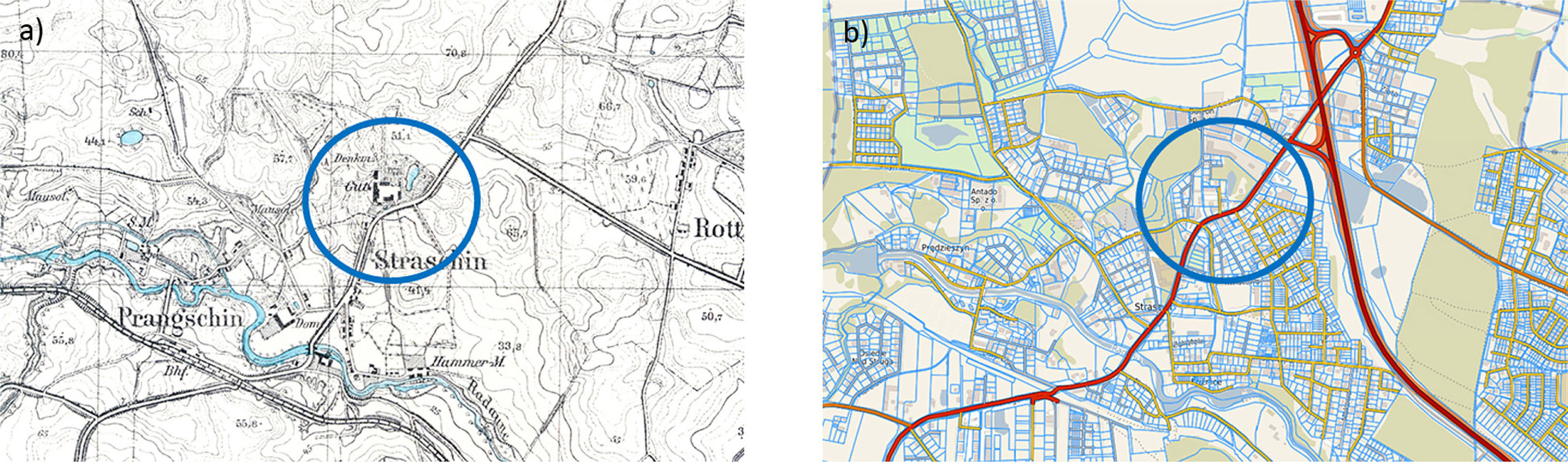
Fig. 7
Development of the spatial layout of Straszyn: (a) 1925 (map of Straszyn 1925), (b) the contemporary plan (map of Straszyn 2019). The blue circle indicates the oldest part of the village and the red line indicates the main road.
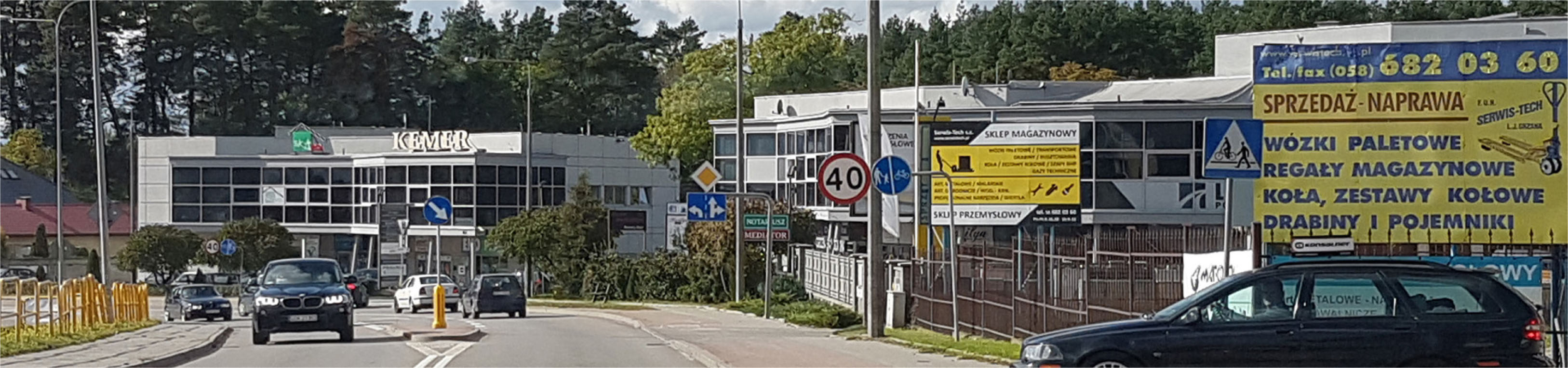
Fig. 8
A complex of service buildings in the centre of Straszyn at Starogardzka Street (road No. 222).
Photo by J. Poczobut, 2019.
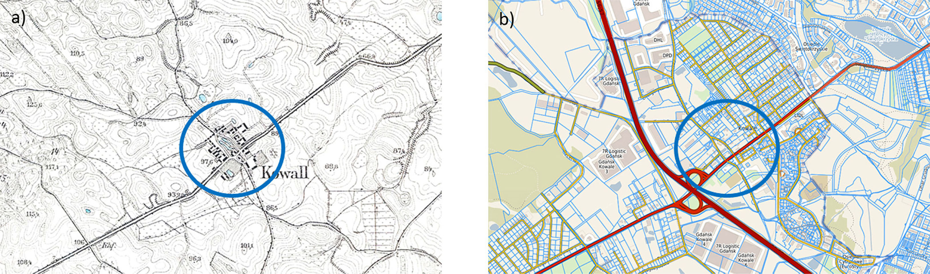
Fig. 9
Spatial arrangement of Kowale village.
(a) 1918 (map of Kowale 1918), (b) contemporary (map of Kowale 2019).
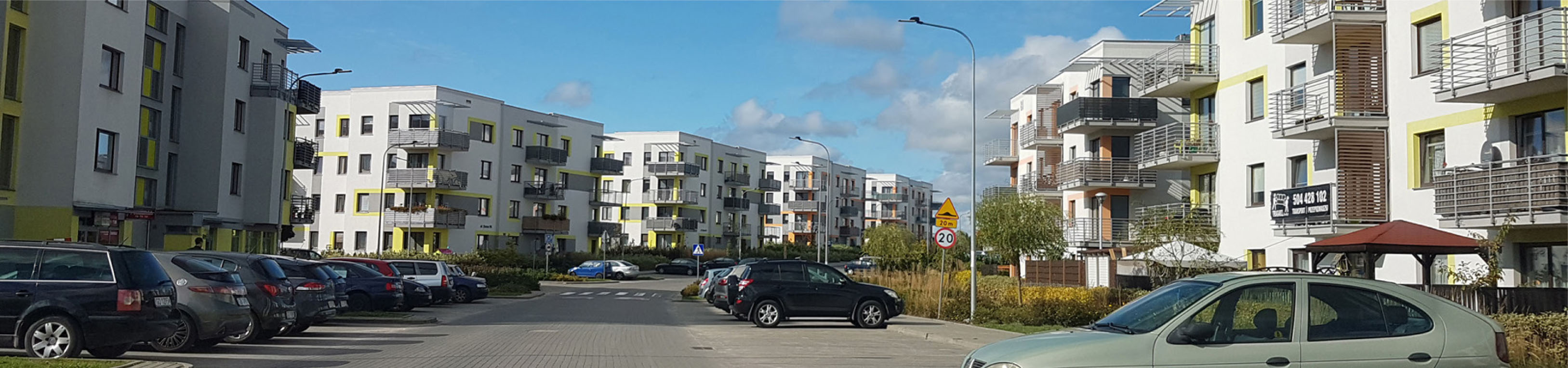
Fig. 10
Metropolitan buildings of the Cytrusowe Housing Estate at Zeusa Street in Kowale.
Photo by J. Poczobut, 2019.
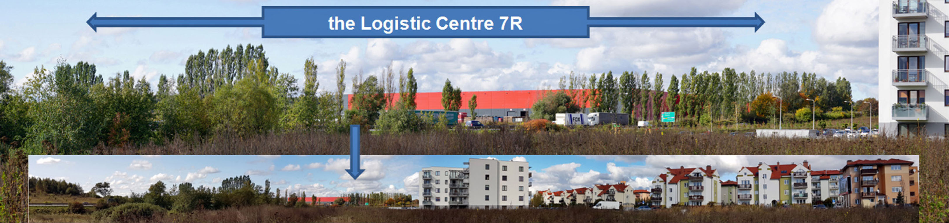
Fig. 11
Buildings of the Logistic Centre 7R Gdańsk Kowale. View from Zeusa Street.
Photo by J. Poczobut, 2019.
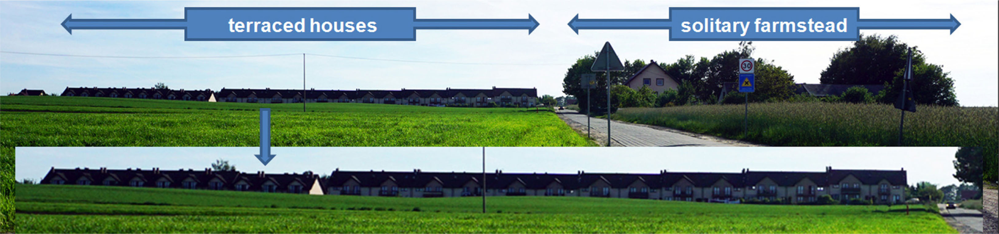
Fig. 12
Panoramic view from Rolnicza Street in Banino (at the exit of Lotnicza Street) in the south-western direction. Different types of buildings: terraced houses and a solitary farmstead.
Photo by J. Poczobut, 2019.
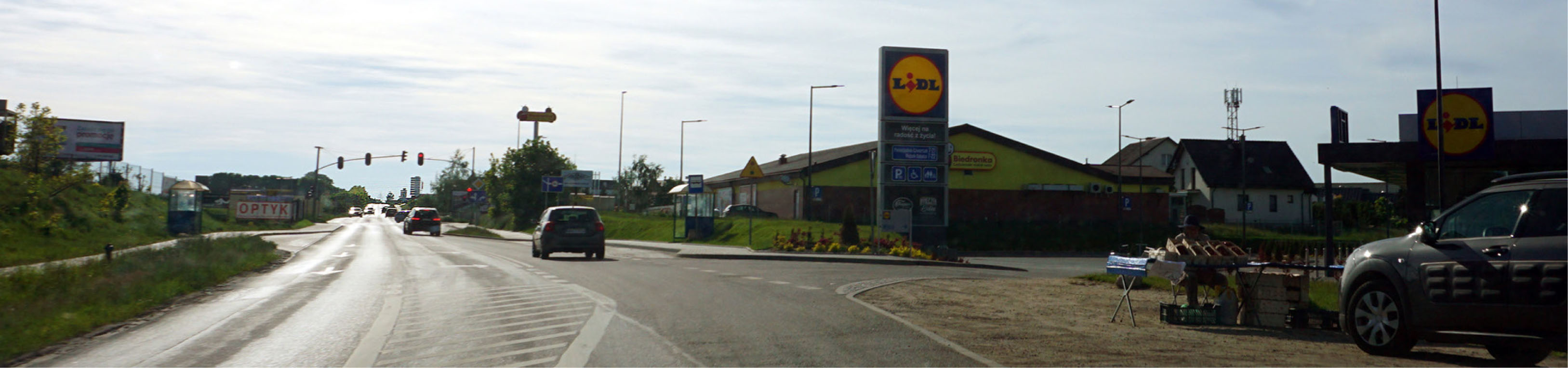
Fig. 13
Lotnicza Street in Banino and a new shopping centre – large-area stores (Lidl and, close behind, Biedronka).
Photo by J. Poczobut, 2019.