
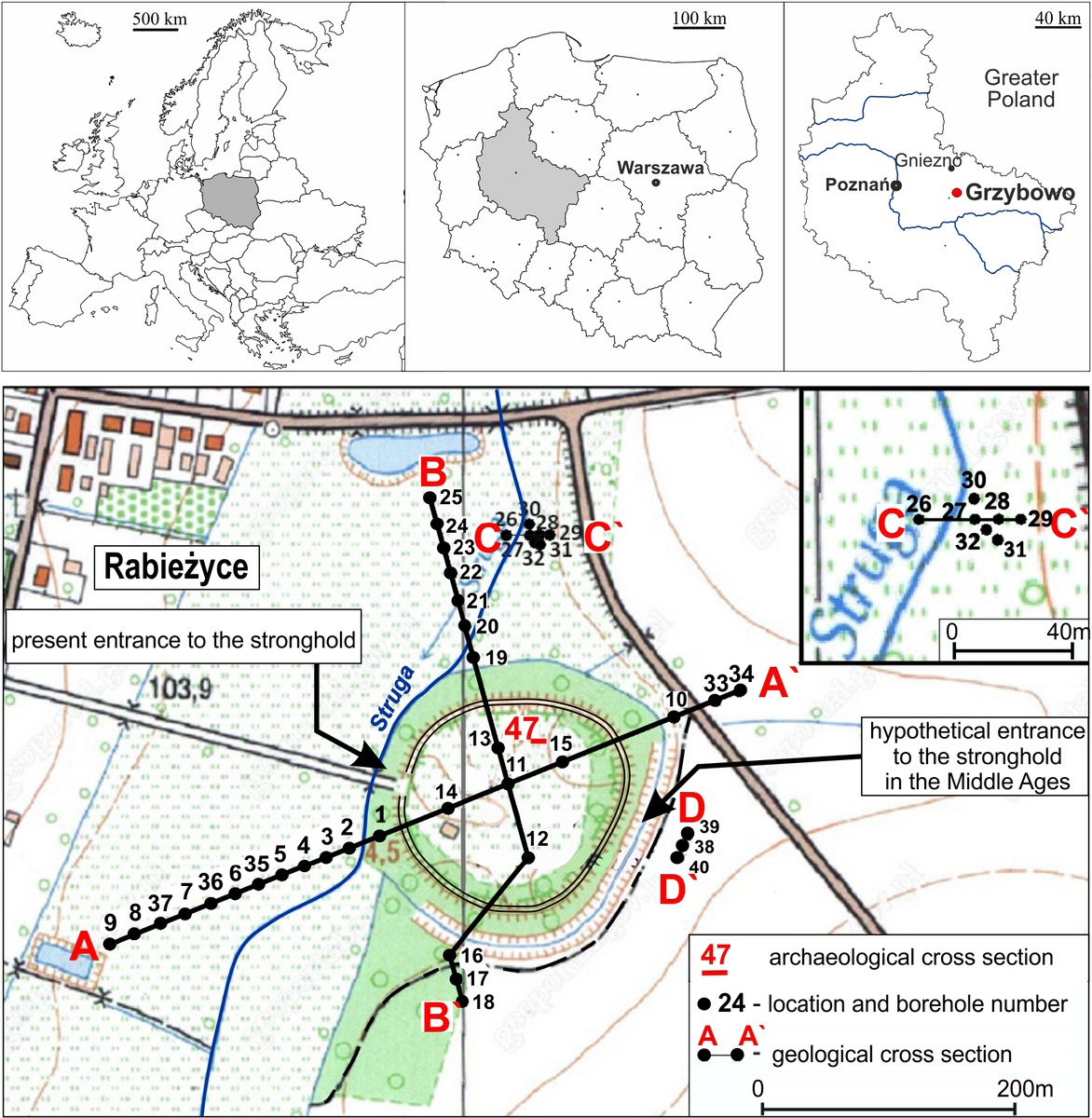
Fig. 1
Location of the study area with marked location of boreholes, cross-section lines of the stronghold area, and archaeological excavation (profile 47).
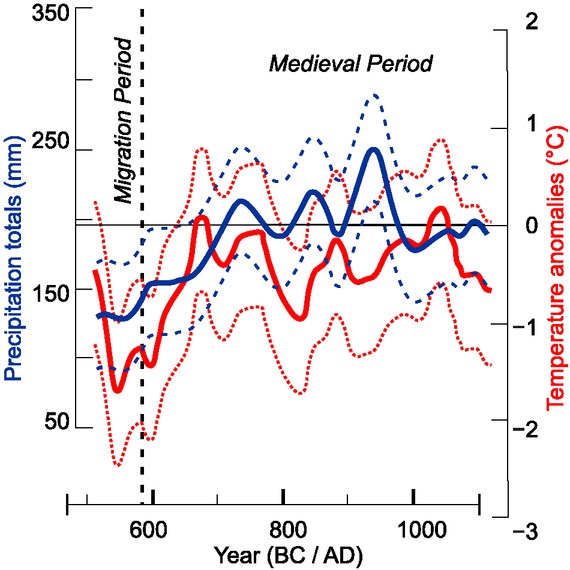
Fig. 2
Amount of precipitation and temperature anomalies in the Middle Ages after Büntgen et al. (2011) – simplified.
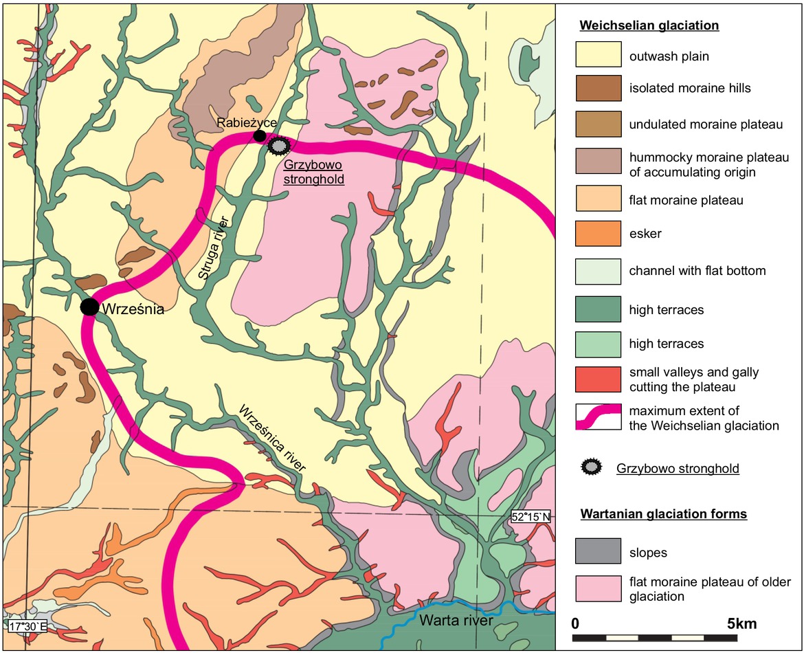
Fig. 3
Fragment of the geomorphological map of Greater Poland after Karczewski et al. (2007), changed.
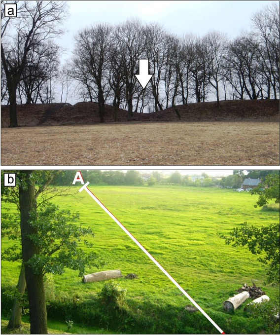
Fig. 4
View of the stronghold. a) lowering in the embankments, b) view to the west of the stronghold with marked cross-section line A-A` exceeding the boundary of the embankments.
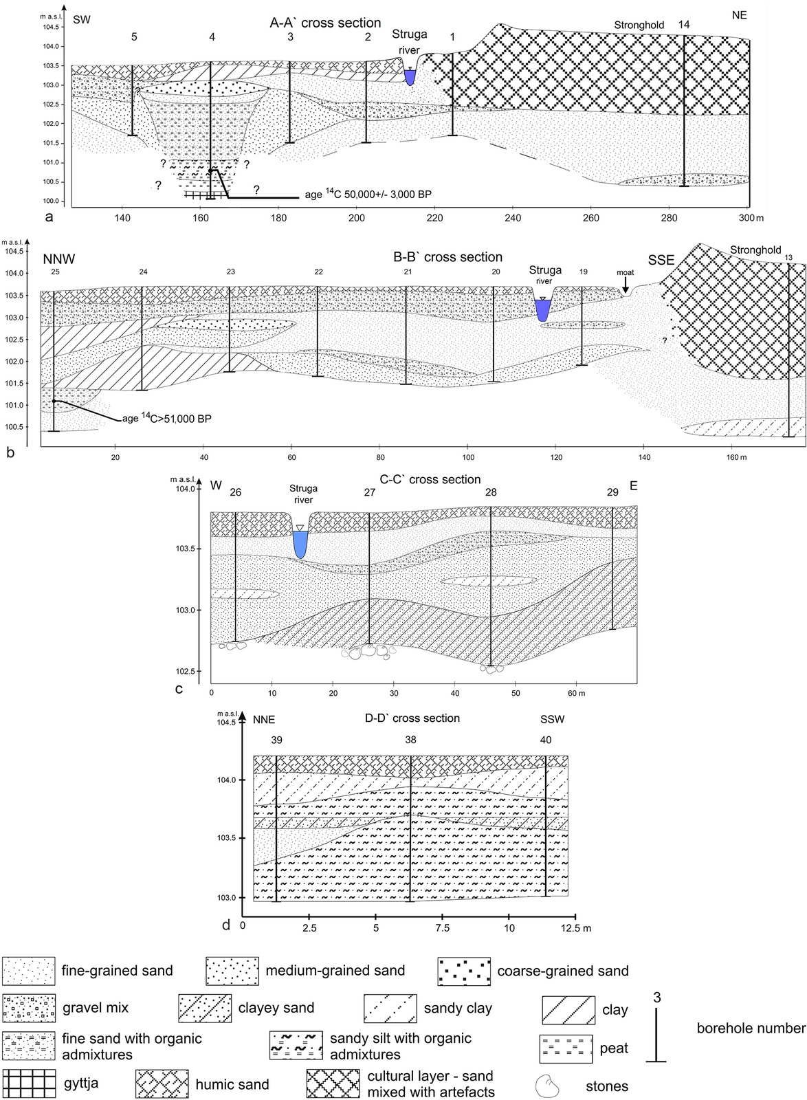
Fig. 5
Geological cross sections around the stronghold. a) fragment of the profile A-A`, b) fragment of the profile B-B`, c) profile C-C`, d) profile D-D`.
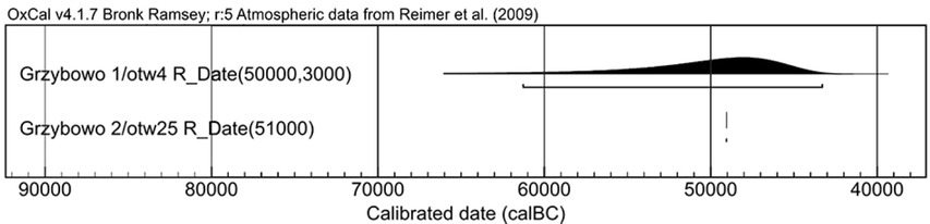
Fig. 6
Calibration of radiocarbon data set in graphical form.
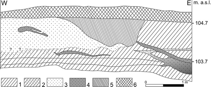
Fig. 7
Profile of archaeological section 47 according to Petri and Bakiewicz (2002, simplified), with a visible outline of a river bed filled with dark-brown sediments.
1 – clay with humic admixtures, 2 – sandy clay, 3 – sand with artefacts, 4 – sand with humus, 5 – dark brown sand, 6 – humic sand (described by archaeologist as an arable layer).
Table 1
Results of the sieve and aerometric analysis for 144 samples from boreholes Nos. 1 to 40.
| Sediments | Number of the samples | |
|---|---|---|
| 1 | Fine-grained sand | 62 samples |
| 2 | Medium-grained sand | 25 samples |
| 3 | Coarse-grained sand | 2 samples |
| 4 | Clayey sand | 5 samples |
| 5 | Sandy clay | 14 samples |
| 6 | Compact clay | 5 samples |
| 7 | Clay | 3 samples |
| 8 | Sandy silt | 3 samples |
| 9 | Gravel mix | 14 samples |
| 10 | Clayey gravel | 11 samples |
Table 2
Loss on ignition analysis of different samples with visible organic matter.
| Borehole No. | Depth [cm] | Ignition loss [%] | Sediment |
|---|---|---|---|
| 1 | 40–60 | 7.91 | Fine-grained sand |
| 4 | 120–150 | 4.95 | Sandy clay |
| 4 | 245–260 | 11.04 | Fine-grained sand |
| 4 | 293–300 | 19.11 | Sandy silt |
| 4 | 300–310 | 47.27 | Peat |
| 4 | 330–350 | 21.35 | Gyttja |
| 8 | 150–180 | 1.64 | Clayey sand |
| 10 | 50–70 | 3.50 | Clay |
| 12 | 20–40 | 2.91 | Fine-grained sand |
| 19 | 25–40 | 9.69 | Gravel mix |
| 19 | 130–150 | 10.85 | Medium-grained sand |
| 25 | 205–220 | 2.56 | Clay |
| 25 | 220–260 | 31.09 | Find-grained sand with organic |
Table 3
Content of CaCO 3 in particular samples.
| Borehole No. | Depth of the sample [cm] | Content of CaCO3 [%] | Sediments |
|---|---|---|---|
| 4 | 330–350 | 22 | Gyttja |
| 24 | 075–100 | 14 | Clay |
| 29 | 50–85 | 14 | Clayey sand |
| 31 | 110–130 | 6 | Clayey sand |
| 33 | 50–70 | 10 | Sandy clay |
| 34 | 35–55 | 9 | Sandy clay |
| 38 | 55–70 | 11 | Sandy silt |
| 39 | 085–100 | 9 | Sandy silt |
| 39 | 185–200 | <5 | Sandy silt |
| 40 | 075–100 | 9 | Sandy silt |
Table 4
Calibration of radiocarbon data set; made with OxCal v4.2.4 (Bronk Ramsey 2013) and IntCal13 atmospheric curve (Reimer et al. 2013).
| Sample no./ borehole no./ depth | Lab. code | Lab. comments | Material | 14C age BP | Age after calibration 68% [BC] | Age after calibration 95% [BC] |
|---|---|---|---|---|---|---|
| Grzybowo 1/ otw4/ 310 cm | Poz-56565 | Date out of range – 50,000±3,000 BP | wood | 50,000±3,000 BP | 52,769 BC (68.2%) 45,099 BC | 61,269 BC (95.4%) 43,298 BC |
| Grzybowo otw25/ 2/ 220–260 cm | Poz-56607 | Date out of range – 51,000 BP | organic fragments from sand | >51,000 BP | (68.249,052 %) 49,051 BC BC | (95.449,052 %) 49,051 BC BC |
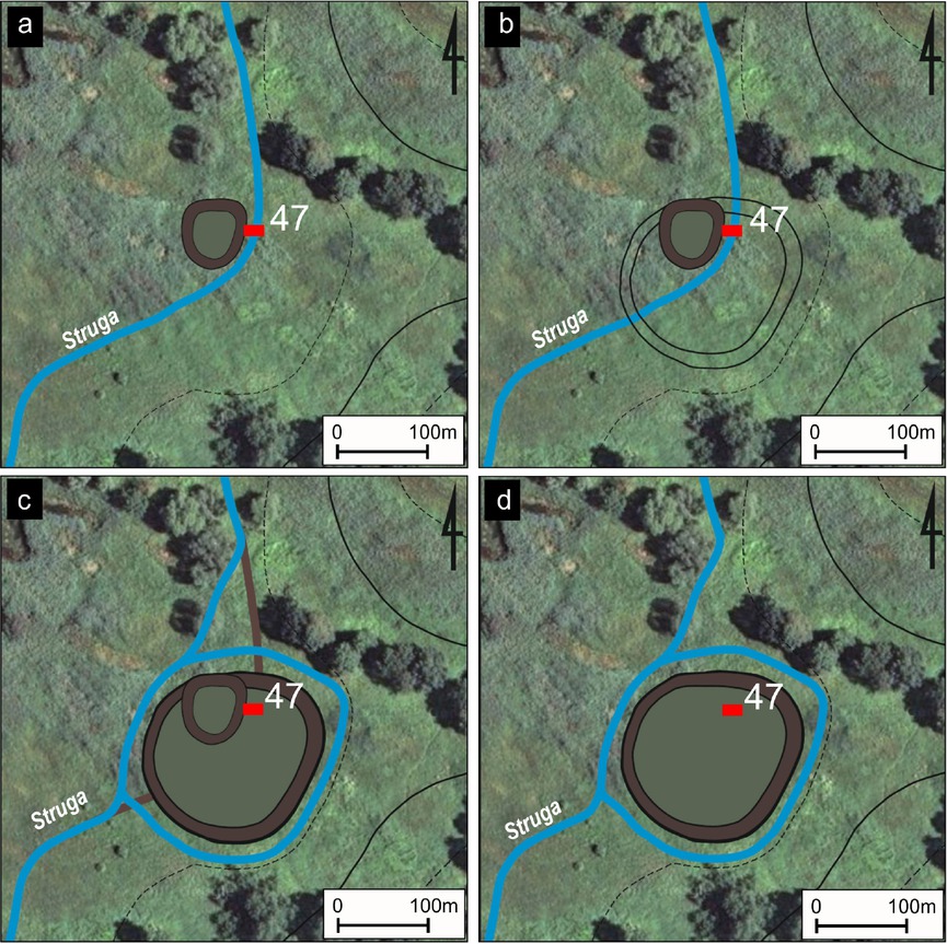
Fig. 8
Proposal of the reconstruction of subsequent stages of the change in the location of the Struga River channel based on geological research, stages of development of the stronghold according to archaeological research results (Petri 2006, Petri, Bakiewicz 2002).
a) and b) the older phase of the ring fort, c) younger phase with visible marked older phase, d) the younger phase of the ring fort; archaeological excavation no. 47 marked by a red colour.