
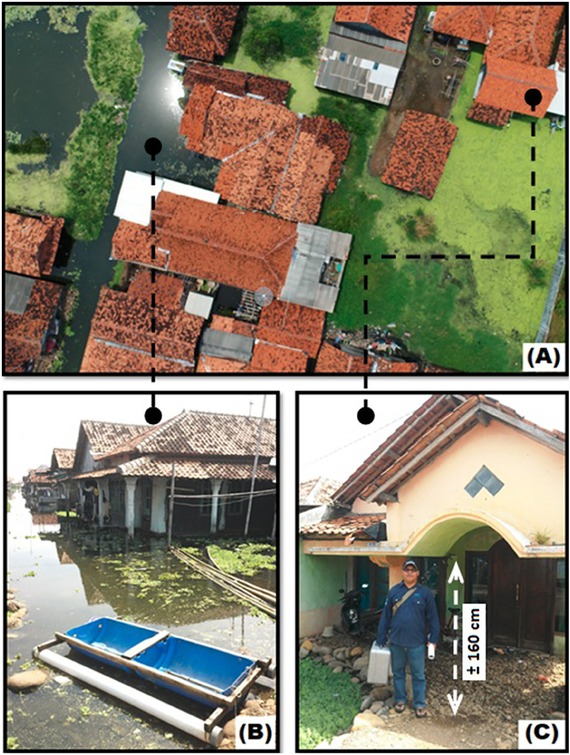
Fig. 1
Environmental conditions in one of the locations affected by tidal flooding in Mulyorejo Village, Tirto District, Pekalongan Regency. (Photos and drone mapping by Yulianto, 2017).
A. Tidal flooding seen from a height of 50 m using drone mapping; B. Non-functioning road infrastructure and inundated houses; C. Community adaptation efforts in dealing with the impact of tidal floods by piling up soil, sand and stone in the yard of a house.
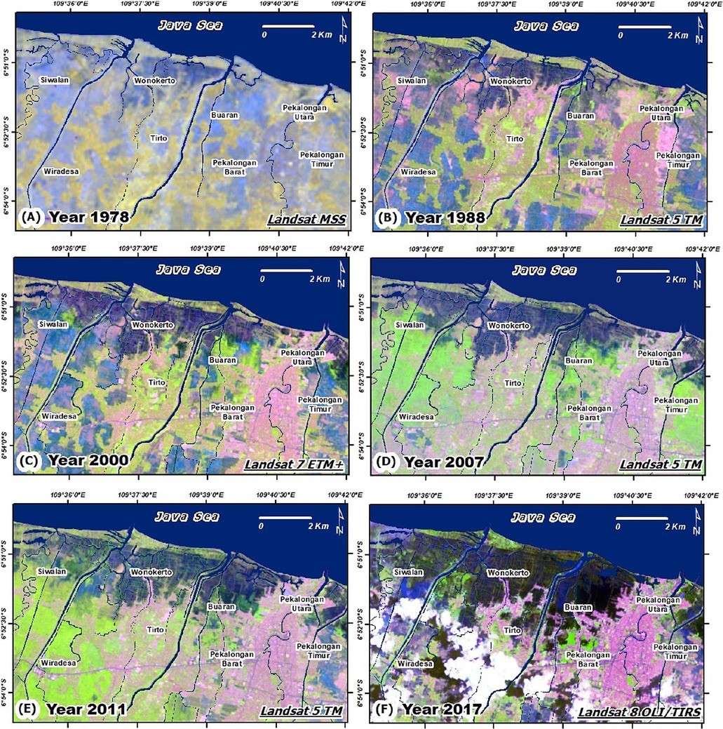
Fig. 2
Landsat images were used to perform coastal landform mapping, consisting of analysis of multi-temporal changes in morphology for 1978 to 2017 in the study area.
A. Landsat MSS 1978; B. Landsat 5 TM 1988; C. Landsat 7 ETM+ 2000; D. Landsat 5 TM 2007; E. Landsat 5 TM 2011; F. Landsat 8 OLI/TIR 2017.
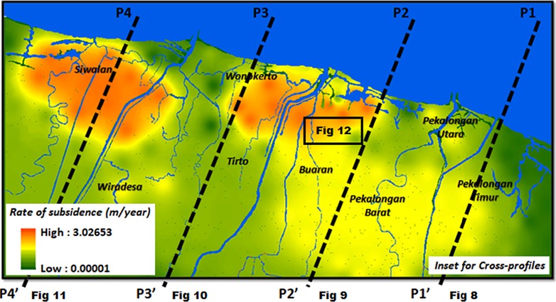
Fig. 3
The rate of subsidence (3 cm yr−1 on average) was obtained based on research by Nashrrullah et al. (2013). Inset are locations for Fig. 8, 9, 10, 11, and 12.
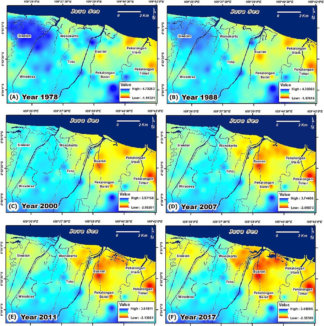
Fig. 4
The results of the dynamics of coastal topographical mapping and modelling for 1978 to 2017 in the study area.
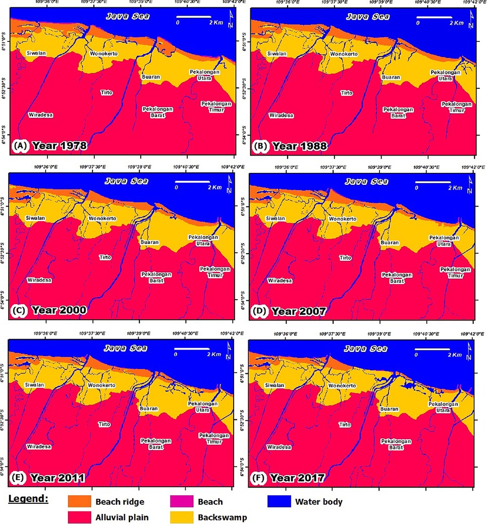
Fig. 5
The results of coastal landform mapping and change from 1978 to 2017 in the study area.
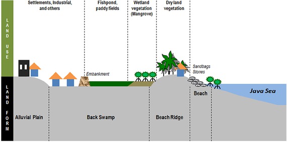
Fig. 6
The relationship between coastal landform profile and land use in the study area.
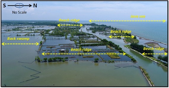
Fig. 7
Landform coastal conditions in 2017 in the study area. The beach ridge, which has an important role as a natural embankment in coastal areas, has been changed into a flat area and is used by local people for ponds (Photo: F. Yulianto 2017).
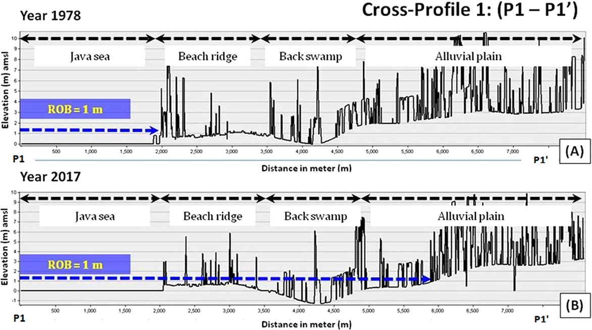
Fig. 8
Comparison results for morphological and topographic condition change from DEM modelling between 1978 and 2017 on cross-profile 1 (P1–P1’) and their implications for vertical tidal flood distribution in coastal landform areas.
A. DEM cross-profile 1 in 1978; B. DEM cross-profile 1 in 2017.
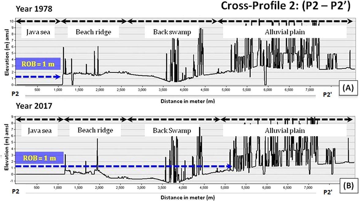
Fig. 9
Comparison results for morphological and topographic condition change from DEM modelling for 1978 and 2017 for cross-profile 2 (P2-P2’) and their implications for vertical tidal flood distribution in coastal landform areas.
A. DEM cross-profile 2 in 1978; B. DEM cross-profile 2 in 2017.
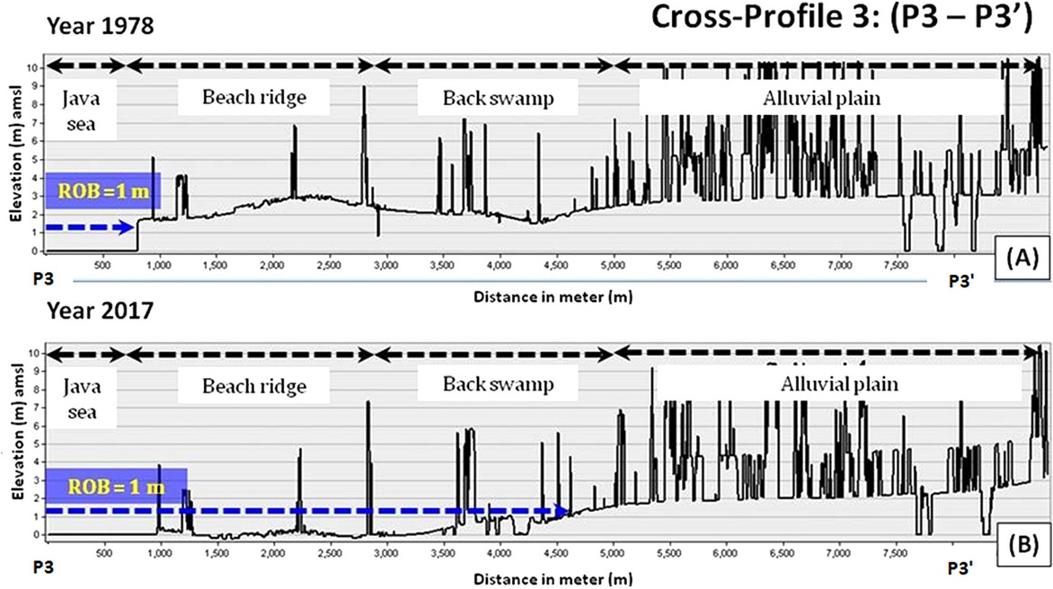
Fig. 10
Comparison results for morphological and topographic condition change from DEM modelling between 1978 and 2017 on cross-profile 3 (P3-P3’) and their implications for vertical tidal flood distribution in coastal landform areas.
A. DEM cross-profile 3 in 1978; B. DEM cross-profile 3 in 2017.
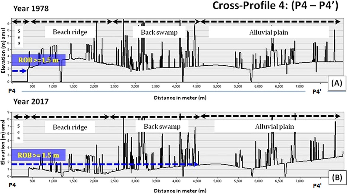
Fig. 11
Comparison results for morphological and topographic condition change from DEM modelling between 1978 and 2017 on cross-profile 4 (P4-P4’) and their implications for vertical tidal flood distribution in coastal landform areas.
A. DEM cross-profile 4 in 1978; B. DEM cross-profile 4 in 2017.
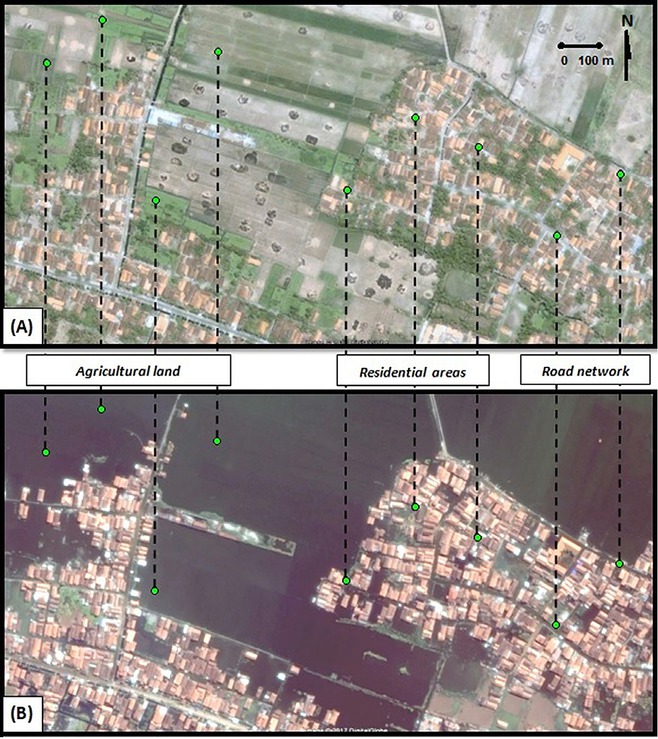
Fig. 12
Areas affected by flooding, such as agricultural land, residential areas and road networks in Jeruksari Village, Tirto District, Pekalongan Regency. (Source: Google Earth; CNES (the French space agency)).
A. Environmental conditions pre-tidal flood, 22 October 2006; B. Flooded conditions during/post-tidal flood, 28 April 2017.
Table 1
Elements of coastal landform classification in the study area.
| Coastal landform | Elements of the coastal landform classification | ||||||||
|---|---|---|---|---|---|---|---|---|---|
| Colour | Texture | Size | Shape | Relief | Site | Slope | Land use | Association of features | |
| Beach | bright white | smooth | narrow | elongated | flat/gently shelving | bordering the sea | 0–3% | bare land | beach, beach ridge and back swamps associate to form a major landscape in the coastal region |
| Beach ridge | bright green | rough | narrow | elongated | undulating | parallel to the beach | 3–8% | shrubs, bushes, croplands | |
| Backswamp | blue | smooth | extensive | elongated/ long | flat | behind the beach ridges | 0% (flat) | water | |
| Alluvial plain | bright green, blue, red | rough | very extensive | elongated/ wide and long | flat/gently sloping | behind the back swamps | 0–3% | various, dominated by settlements and paddy fields | the main depositional landforms bordering the coastal region |
Table 2
The estimated area of coastal landform change for 1978 to 2017 in the study area.
| Coastal landform | Year | |||||
|---|---|---|---|---|---|---|
| 1978 (ha) | 1988 (ha) | 2000 (ha) | 2007 (ha) | 2011 (ha) | 2017 (ha) | |
| Beach | 9 | 15 | 21 | 25 | 17 | 14 |
| Beach ridge | 727 | 713 | 642 | 584 | 578 | 465 |
| Backswamp | 2324 | 2333 | 2336 | 2359 | 2364 | 2379 |
| Alluvial plain | 7763 | 7640 | 7495 | 7286 | 7260 | 7151 |
Table 3
The estimate of the average rate area of coastal landform change for the year 1978 to 2017 in study area.
| Coastal landform | Change area (ha) | Average change area (ha yr−1) 1978–2017 | ||||
|---|---|---|---|---|---|---|
| 1978–1988 | 1988–2000 | 2000–2007 | 2007–2011 | 2011–2017 | ||
| Beach | +6 | +6 | +4 | −8 | −3 | +0.38 |
| Beach ridge | −14 | −71 | −58 | −6 | −113 | −6.72 |
| Backswamp | +9 | +3 | +23 | +5 | +15 | +1.41 |
| Alluvial plain | −123 | −145 | −209 | −26 | −109 | −15.69 |
[i] + – increase, −– decrease.
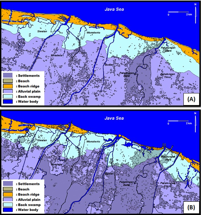
Fig. 13
Comparison of settlement distribution located on coastal landform between 1978 and 2017 in the study area.
(A) Settlement on coastal landforms in 1978; (B) Settlement on coastal landforms in 2017.
Table 4
Settlements and average area comparisons for coastal landforms for 1978 and 2017 in the study area.
| Coastal landform | Year | Average area of increase (ha yr−1) 1978 to 2017 | |
|---|---|---|---|
| 1978 area (ha) | 2017 area (ha) | ||
| Beach | 0.08 | 6.36 | 0.16 |
| Beach ridge | 25.24 | 66.11 | 1.05 |
| Backswamp | 99.54 | 396.90 | 7.63 |
| Alluvial plain | 1388.75 | 3962.76 | 66.01 |