
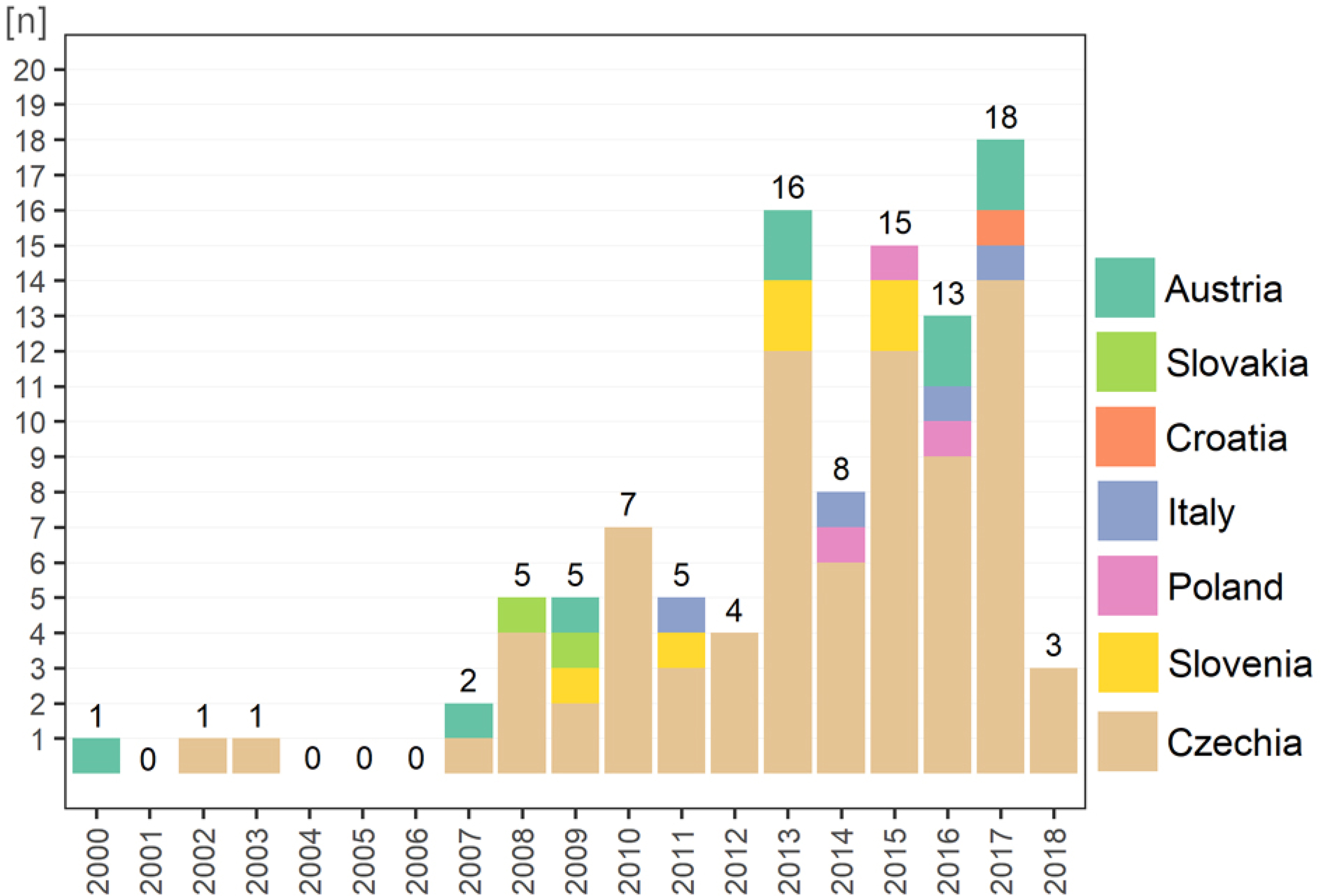
Fig. 1
Publication frequency and the localization of the record.
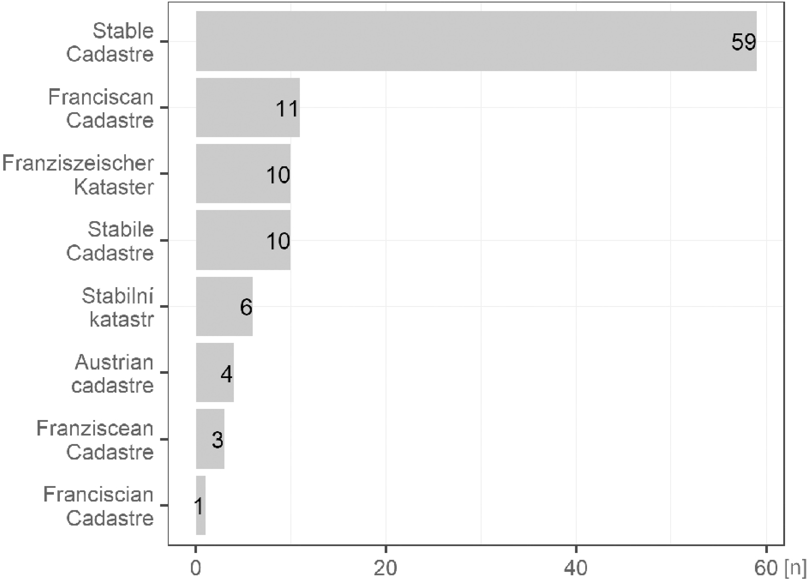
Fig. 2
Terms used for retrieval of the record.
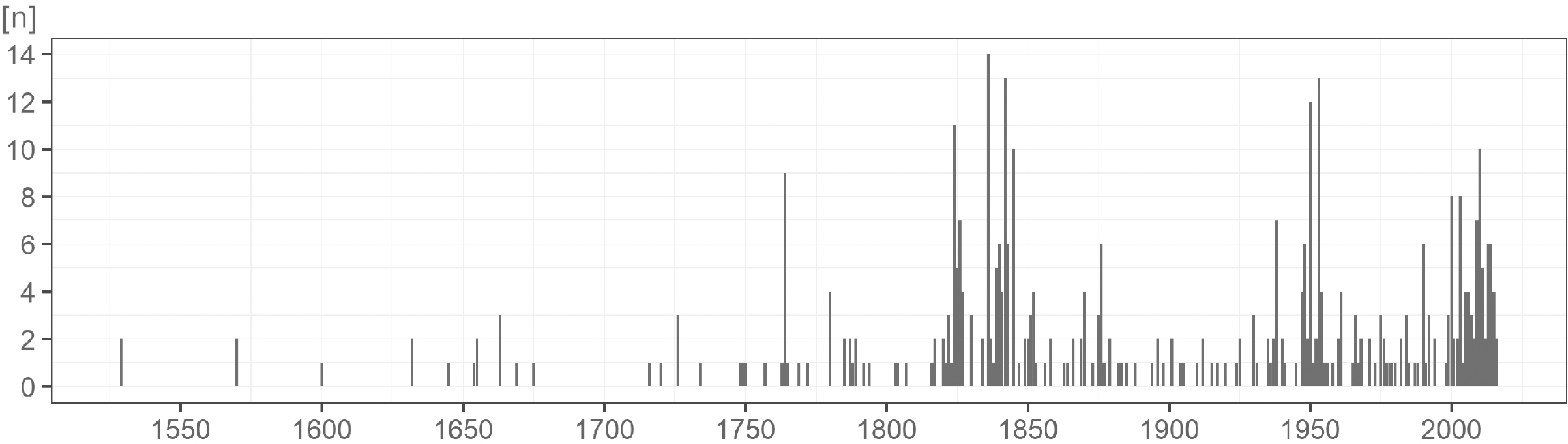
Fig. 3
Map and other sources dating frequency (note: figure include the FC).
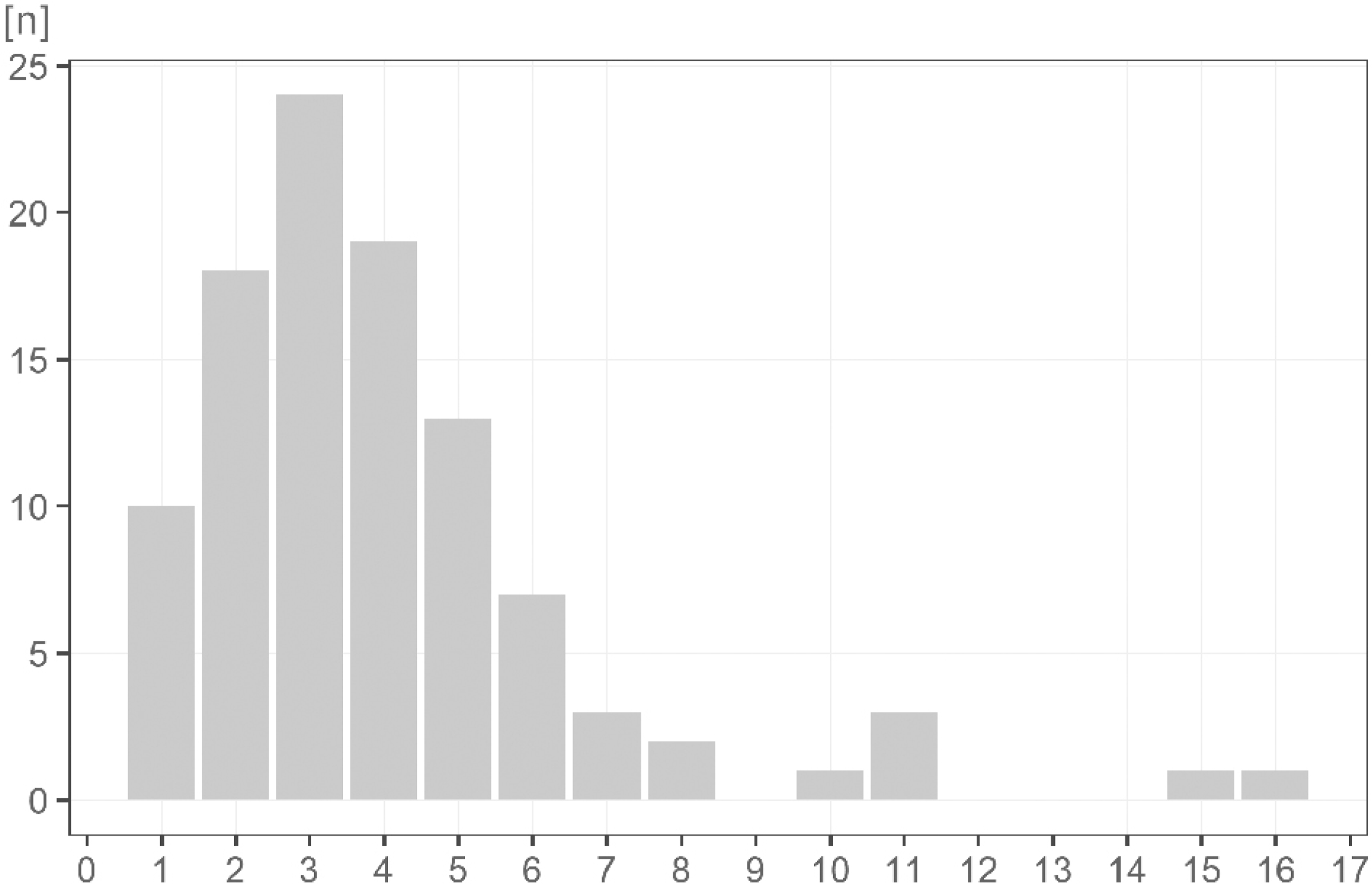
Fig. 4
Number of time points involved in the records (note: figure include the FC).
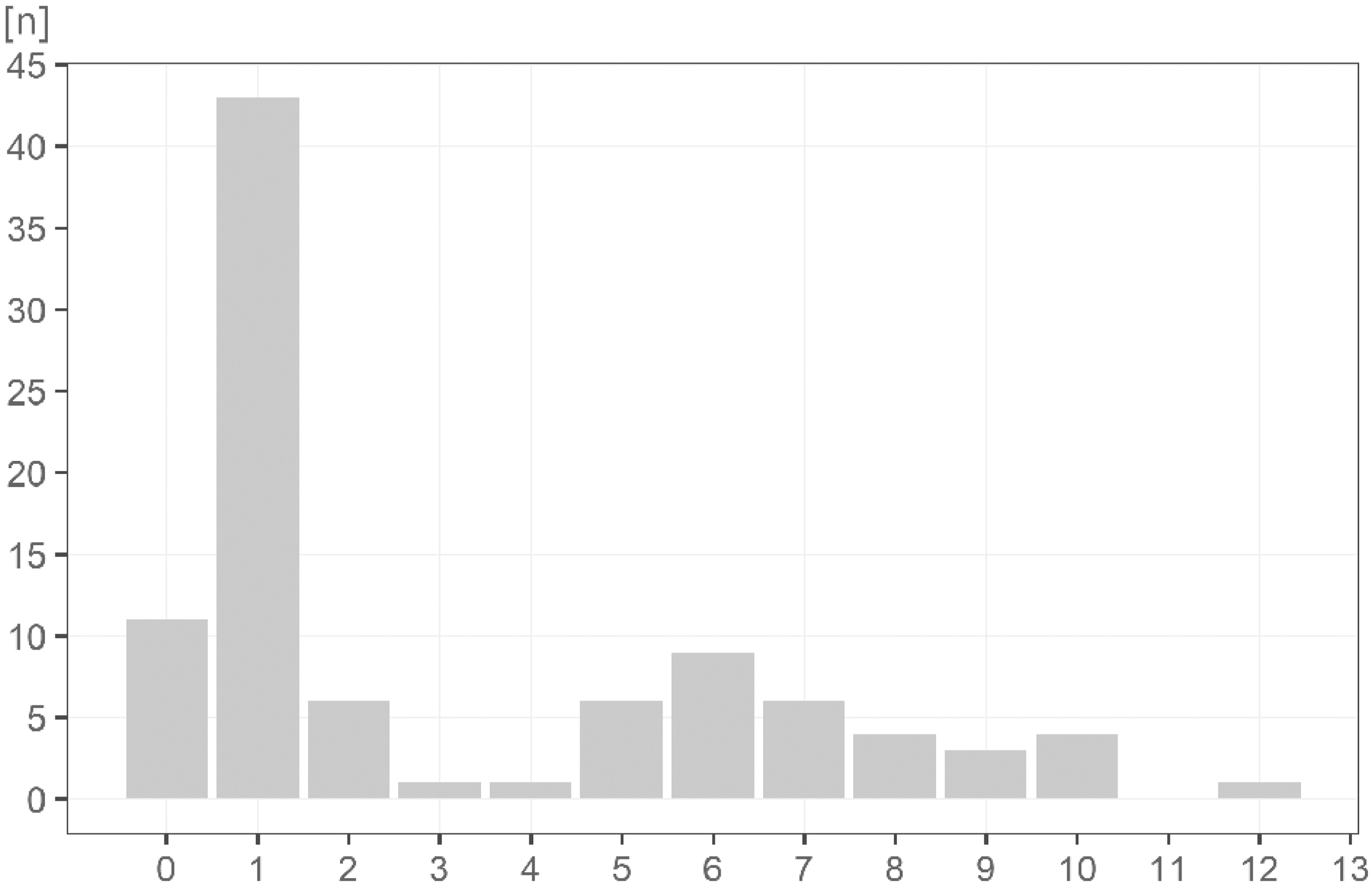
Fig. 5
Number of LULC classes employed in the record.
Table 1
Frequency table of LULC classes.
| LULC class | Frequency |
|---|---|
| Built-up areas (yards) | 36 |
| Forest | 39 |
| Coniferous forests | 1 |
| Deciduous forests | 1 |
| Coppice woods | 1 |
| Slash and Burn areas | 1 |
| Agricultural land | 3 |
| Arable land | 30 |
| Arable land with trees | 2 |
| Arable land with vineyards | 1 |
| Arable land with olive trees | 1 |
| Orchards | 14 |
| Vineyards | 12 |
| Vineyards with trees | 1 |
| Vineyards with olive trees | 1 |
| Hop fields | 2 |
| Meadows and Pastures | 10 |
| Meadows | 18 |
| Meadows with trees (fruit trees) | 5 |
| Pastures | 13 |
| Pastures with trees (fruit trees) | 5 |
| Water bodies (lakes, fish ponds) | 28 |
| Water streams, rivers | 18 |
| Gardens | 15 |
| Non forest woody vegetation | 13 |
| Roads, paths | 9 |
| Swamps, wetlands | 7 |
| Barren land | 6 |
| Mining sites, Rocks | 4 |
| Others | 11 |
| Administrative boundaries | 2 |
| LULC classes not extracted | 6 |

Fig. 6
Part of the Franziscean cadastre involved in the study.
IS – indication sketches, CE – Cadastral Elaborat, OM – original maps, WR – written registry, CII – Compulsory Imperial imprints, N/A – not available.
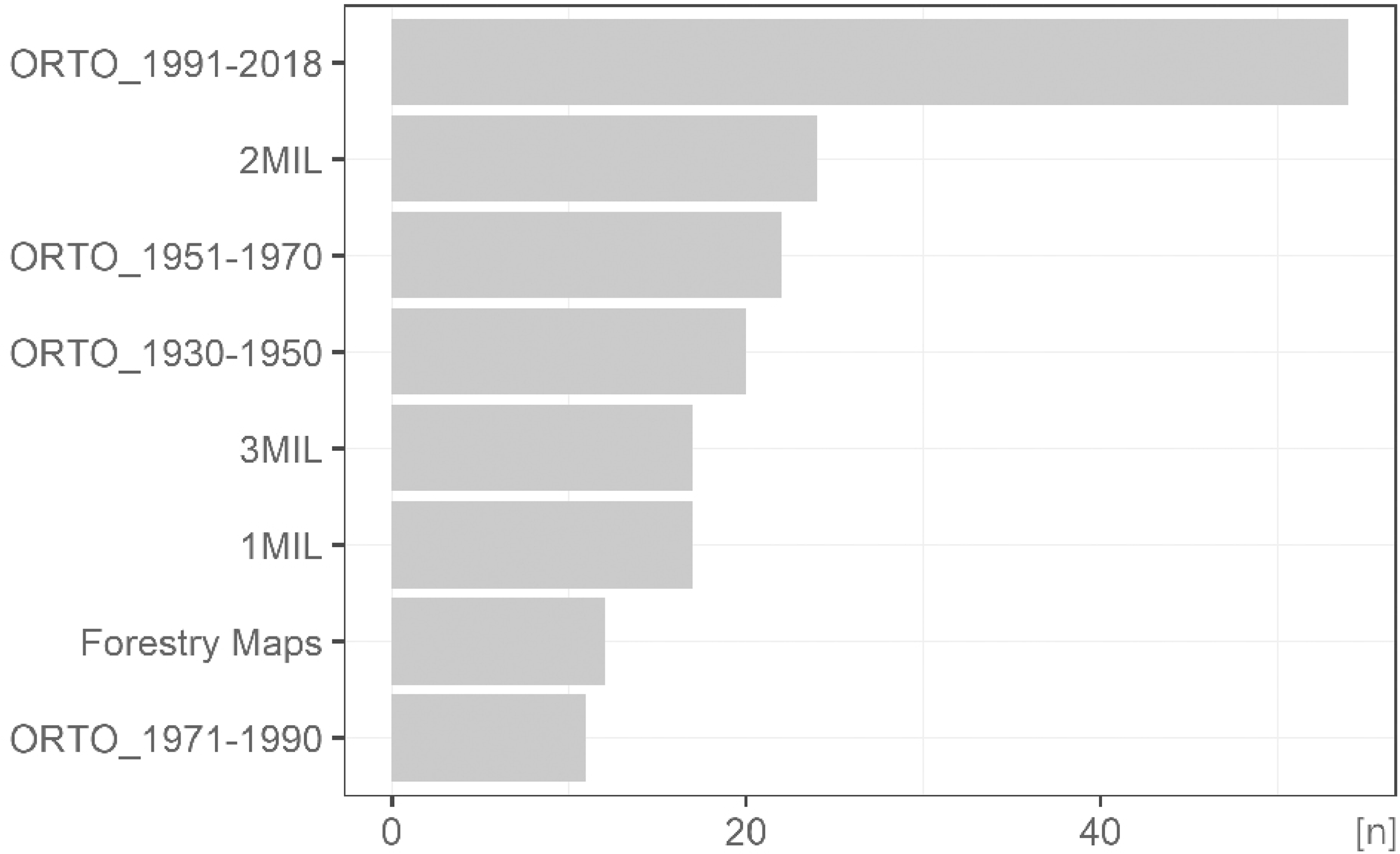
Fig. 7
Frequency of the supplementary data sets used. ORTO – orthophoto, MIL – Millitary mapping.
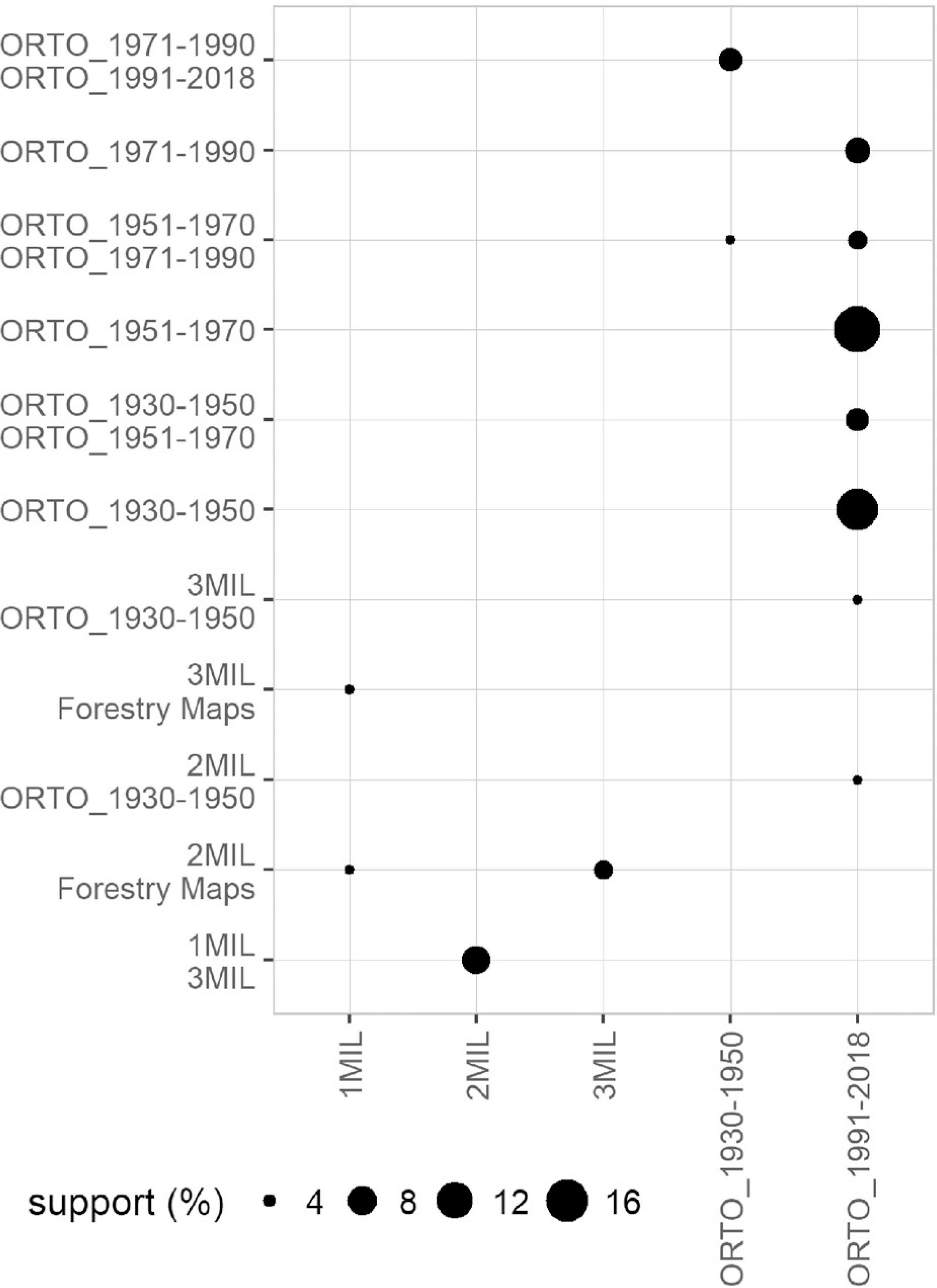
Fig. 8
Association between map and data sources.
MIL – Military mapping, ORTO – orthophoto/aerial imagery.
| Group | Feature | Description | Categories, Values (min.–max., SD) |
|---|---|---|---|
| Bibliographic info | Keyword | Database keyword used for search for record | Franziszeischer Kataster, Franciscian Cadastre, Stable Cadastre, Stabile Cadastre, Franciscan Cadastre, Františkánský katastr, Stabilní katastr and Austrian cadastre |
| Type | Type of the record | Article, Conference proceedings, Book Chapter, Review | |
| Year | Year of publishing | 2000–2018, 3.54 | |
| Article keywords | Keywords used in record | Comma delimited text | |
| State | Place of case study | Czechia, Croatia, Austria, Italy, Poland, Slovakia, Slovenia | |
| Purpose and general source | Cadastral maps | Indication of cadastral maps use | YES/NO |
| Written registry | Indication of written registry use | YES/NO | |
| Purpose of the study – general | General categories of the purpose | Landscape – general category; Streams and water bodies; Agricultural land; Forests, Forestry; Reconstruction models; Ownership and property rights; Demography | |
| Purpose of the study – detailed | Detailed description of the purpose | Text description (e.g. stream and water bodies localization, land use / land cover change | |
| Methodology and data manipulation | Multitemporality | Application of multiple time segments | YES/NO |
| Number of time points | Number of time segments applied | 1–16, 2.73 | |
| Years of time points | Years of time segments used | 1529–2016, 97.61 | |
| Other map sources | Categorization of other map sources | abbreviation of map source (e.g. 2MIL – Second military mapping, ORTO_1991–2018 – orthphoto originating from 1991–2018) | |
| Other data sources | Categorization of other data sources | abbreviation of data source (e.g. URB – Urbaria, FS – Field Survey, SCH – Soil Chemistry) | |
| Type of LULC | LULC categories extracted, applied | full name of category provided by author (i. e. Vineyards, Arable land with fruit trees) | |
| Number of LULC classes | Count of distinguished LULC classes | 0–12, 3.24 | |
| LULC – map | LULC classes derived solely from map | YES/NO | |
| Georefference of map Sheet | Indicated GIS manipulation mentioned | YES/NO | |
| Vectorization/digitization of map | Indicated GIS manipulation mentioned | YES/NO | |
| Spatial scale | Scale of the study | Spatial scale of the study | administrative scales – Cadastre, Municipality, County, Region, State; individual scales – mountain range, protected area, river, river basin |
| Explicit scale of the study | Acreage under study as reported by authors | 0.23–12,200, 2111.29 (n=32) |