
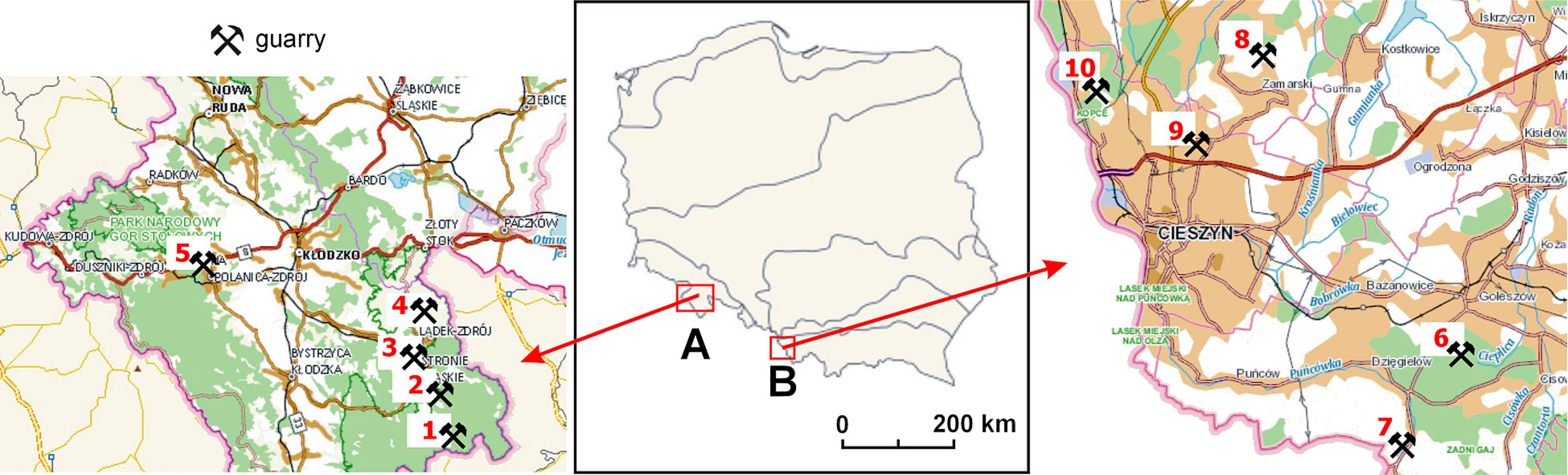
Fig. 1
Location of the selected quarries in the Kłodzko Region (A) and Cieszyn Foothills (B). 1 – Kletno, 2 – Krzyżnik, 3 – Sinica, 4 – Czarne Urwisko, 5 – Szczytna Zamek, 6 – Na Jesieniowej, 7 – Na Mołczynie, 8 – Grota na Rudowie, 9 – Nad Kalembianką, 10 – Ondraszkowa Dziura.
Table 1
Criteria for geotourism valorisation and scoring categories.
| I – Educational value | Point score |
|---|---|
| high (object with a rare type of geological and geomorphological structure) | 3 |
| medium (object with a frequent type of geological and geomorphological structure) | 2 |
| low (object with a common type of geological and geomorphological structure or without such) | 1 |
| II – Scientific value | |
| high (found in national scientific literature) | 3 |
| medium (found in regional scientific or popular science literature) | 2 |
| low or none | 1 |
| III – Visual value (accessibility of geological structure for direct observation) | |
| high (geological and geomorphological structures are very visible) | 3 |
| medium (geological and geomorphological structures are partially visible, possibility of clearing the rock walls) | 2 |
| low (geological and geomorphological structures are visible only in places – obscured by vegetation or not visible at all) | 1 |
| IV – Location value in terms of accessibility | |
| easily accessible, marked | 3 |
| accessible, unmarked | 2 |
| poorly accessible, unmarked | 1 |
| V – Cultural value | |
| very close connection with the history of the region and mining | 3 |
| medium connection with the history of the region and mining | 2 |
| little or no connection with the history of the region and mining | 1 |
| VI – Infrastructural value (geotourism development) | |
| high (geotourism route, accompanying facilities) | 3 |
| medium (information board on site) | 2 |
| low or none | 1 |
| VII – Legal protection value | |
| high (national rank) | 3 |
| medium (regional rank) | 2 |
| low (local rank) or none | 1 |
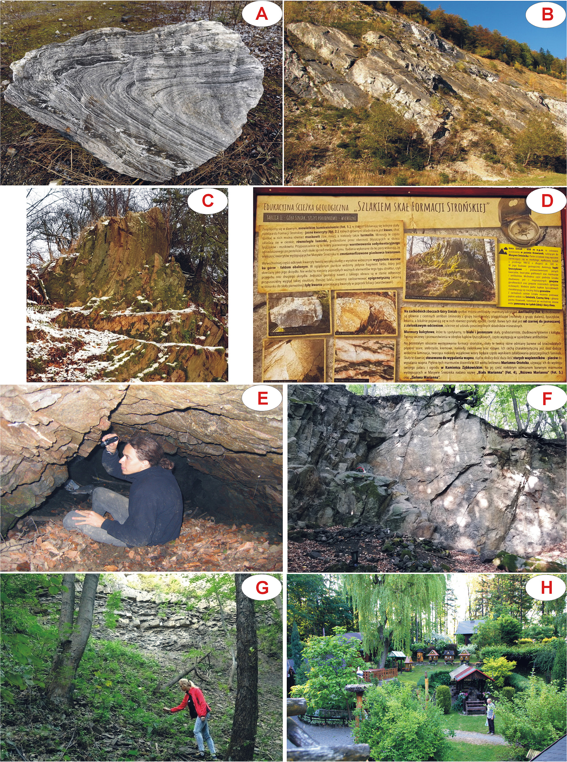
Fig. 2
Examples of geological structures and tourist infrastructure in the quarries. A – Krzyżnik, B – Kletno I; C, D – Sinica, E – Ondraszkowa Dziura (adit of teschenites), F – Grota na Rudowie, G – Na Jasieniowej, H – Na Mołczynie.
Table 2
Natural and historical attractions, and development of selected quarries.
| No of object | Name of object | Type of extracted rock material | Exploitation history | Natural and historical attractions | Present condition and tourist infrastructure |
|---|---|---|---|---|---|
| 1 | Kletno I | marble | second half of the 19th century; 1930 and 1958–1993 | exploitation levels forming steps; rock shelters; small water reservoir; sites of Dactylorhiza fuchsii subsp. Fuchsie, Rupicapra rupicapra | accessible to tourists; tourist trail; Śnieżnik Landscape Park |
| 2 | Krzyżnik | crystalline limestone | from the 19th century to the 1990s | recumbent fold; traces of mining blasting works | accessible to tourists; overgrown with vegetation, littered, with traces of bonfires |
| 3 | Sinica | gneisse, quartzite | 19th century and early 20th century | flank of overturned fold; veins of quartz | accessible to tourists; overgrown with vegetation; scenic point; information boards |
| 4 | Czarne Urwisko | basalt | 19th century | volcanic pipe; basalt poles | accessible to tourists; overgrown with vegetation, walking trail; scenic point; benches; Śnieżnik Landscape Park |
| 5 | Szczytna Zamek | sandstone | from 1892 till now, episodic exploitation, as per demand | large rock blocks; exploitation levels forming steps | poorly accessible to tourists; no tourist infrastructure |
| 6 | Na Jasieniowej | Cieszyn limestones, marly schist | from the 17th century to the second half of the 20th century; in 1942–1945 the area of the quarry was the workplace of the prisoners of the Auschwitz sub-camp in Goleszów | outcrop of Carpathian flysch with rich paleontological material; rock shelter, so-called Shelter in Jasieniowa (Ps-01.03); in the area of the quarry there are excavation complexes (one of them serves as a water reservoir Ton), a karst lake Pod Księżycem with fragments of an old hydrotechnical construction and traces of historical traction of cableway and narrow-gauge railway; site of mountain newt Triturus alpestris | poorly accessible to tourists, overgrown with vegetation; a status of documentation site, with an information board; scenic point; tourist trails (from Goleszów to Wielka Czantoria, communal walking trail Jasieniowa, didactic path Nature has no limits) |
| 7 | Na Mołczynie | Cieszyn limestones | first half of the 20th century | outcrops of Cieszyn limestones; artificially introduced fauna – including honey plants | easily accessible to tourists; private apiary farm Bee Town composed of beehives in the shape of highland huts, apiary workshop and rock horticulture compositions; scenic point; numerous tourist trails (the Main Carpathian Bicycle Trail and the Border Trail, Traditional Crafts of Cieszyn Silesia Trail) |
| 8 | Grota na Rudowie | teschenites | 19th century or early 20th century | rock poles of coarse and medium-grain teschenites; site of Langemannia gigantea; in the area of the quarry traces of iron ores exploitation | easily accessible to tourists; religious (St Mary’s) worship site in a rock shrine, also known as Quarry with a shrine; benches |
| 9 | Nad Kalembianką | teschenites | 19th century or early 20th century | intrusion of teschenites bordering on upper Cieszyn schist and metamorphic formations; site of Hacquetia epipactis | accessible to tourists; littered, situated on private ground, with documentation necessary to prepare a documentation site (Lamparska-Wieland 2001) |
| 10 | Ondraszkowa Dziura | teschenites | 19th century or early 20th century | intrusion of teschenites, also known as Shelter in Marklowice (K.Ps-01.01S); former teschenites adit (?); traces of mining blasting works; traces of opencast extraction of Cieszyn limestone; site of Boettgerillidae | accessible to tourists; located within the Kopce forest nature reserve; devastated due to illegal excavation in 2005 |
Table 3
Results of geotourism valorisation of selected quarries.
| No of object | Name of object | Category | Point score | ||||||
|---|---|---|---|---|---|---|---|---|---|
| I | II | III | IV | V | VI | VII | |||
| 1 | Kletno I | 2 | 2 | 3 | 2 | 3 | 1 | 2 | 15 |
| 2 | Krzyżnik | 3 | 3 | 3 | 2 | 3 | 1 | 1 | 16 |
| 3 | Sinica | 2 | 1 | 2 | 3 | 1 | 3 | 1 | 13 |
| 4 | Czarne Urwisko | 3 | 3 | 3 | 3 | 3 | 2 | 2 | 19 |
| 5 | Szczytna Zamek | 2 | 1 | 1 | 2 | 1 | 1 | 1 | 9 |
| 6 | Na Jasieniowej | 3 | 3 | 2 | 1 | 3 | 2 | 3 | 17 |
| 7 | Na Mołczynie | 1 | 2 | 1 | 3 | 3 | 3 | 1 | 14 |
| 8 | Grota na Rudowie | 3 | 3 | 3 | 2 | 3 | 1 | 1 | 16 |
| 9 | Nad Kalembianką | 3 | 3 | 3 | 1 | 3 | 1 | 1 | 15 |
| 10 | Ondraszkowa Dziura | 2 | 3 | 3 | 1 | 3 | 1 | 3 | 16 |