
Gamma radiation monitoring is crucial for environmental safety, particularly following nuclear contamination events or in regions with naturally occurring radioactive materials. Recent advancements in drone technology and miniaturized radiation detectors have opened new possibilities for environmental monitoring. Unmanned aerial vehicles (UAVs) equipped with radiation sensors offer several advantages over traditional ground-based or manned aircraft surveys, including reduced human exposure to radiation, improved access to difficult terrain, and enhanced cost-effectiveness [1].
Conventional radiometric surveys typically rely on large, expensive aircraft systems equipped with sophisticated detectors, which limit accessibility and deployment flexibility. While these systems provide high-resolution data and spectral information, their cost and complexity restrict their use to well-funded organizations and planned campaigns, creating a gap in rapid response capabilities and routine monitoring. This gap is especially problematic for smaller organizations or emergency scenarios that demand rapid deployment.
This study addresses this gap by evaluating the effectiveness of a low-cost UAV-based system for ra-diation monitoring. We used a consumer-grade DJI Phantom 2 quadcopter paired with a GammaRAE II R dosimeter, creating an affordable, portable, and easy-to-use system. Our approach illustrates the adaptation of consumer technology for scientific applications, with the goal of democratizing access to radiation monitoring capabilities. The Třebsko site in the Czech Republic was selected as our test area due to its advantageous characteristics. Previous high-resolution gamma radiation surveys in this area have revealed detailed spatial variations associated with thorium and uranium concentrations in the underlying rock formations [2]. This benchmark data is valuable for validating our system’s performance, and the site’s diverse geological features make it ideal for detecting radiation anomalies.
The objectives of this research are to assess the feasibility of using a low-cost UAV system for gamma radiation surveys, to validate system capabilities through comparison with high-resolution surveys, to evaluate potential applications in environmental monitoring, emergency response, and education, and to demonstrate the viability of open-source data processing tools for radiation mapping. By addressing these objectives, we contribute to the growing body of knowledge on UAV-based radiation monitoring and provide practical insights into the application of consumer-grade technology in scientific research. This work ultimately aims to bridge the gap between sophisticated professional systems and the need for accessible, rapidly deployable radiation monitoring solutions.
The survey was conducted in Třebsko, a rural region in central Bohemia, Czech Republic, approximately 60 km southwest of Prague. Třebsko sits within a geologically diverse area of Paleozoic sedimentary rocks, metamorphic schists, and basalt from past volcanic activity. This area was chosen for its diverse geological formations, including granite and metamorphic rocks, which create variations in natural background radiation, making it ideal for detecting small anomalies in radiation distribution. Nearby Pribram, historically significant for uranium mining during the 20th century, contributed to Czechoslovakia’s nuclear development [3]. The region is also known for silver and gold deposits, reflecting the broader tectonic history of the Bohemian Massif.
Previous high-resolution gamma-ray spectrometry surveys at this site revealed significant spatial patterns linked to underlying geological structures [2], providing a valuable benchmark for validating the results of our low-cost UAV system. The site’s rural setting allows for safe, unobstructed UAV flights, minimizing risks typically associated with populated areas. The region’s mix of open fields, wooded areas, and gentle topography also offers a realistic testing ground for evaluating the system’s performance under varied environmental conditions. These factors make Třebsko an excellent location for assessing the feasibility of UAV-based gamma radiation monitoring in a real-world setting.
Our study employed a combination of consumer-grade UAV technology and a personal radiation detection instrument.
The UAV we used was DJI Phantom 2 quadcopter, a widely available consumer drone known for its stability and ease of use. Although now obsolete, this model was deliberately chosen for several reasons. In terms of its specifications, it represents basic UAV technology, most consumer UAVs commonly used today outperform it, and replacing this drone with another should only deliver better results (primarily in-flight accuracy). The second factor is price. This model can be purchased for under USD 200, which may be significant in certain regions. This UAV model offers a flight time of approx. 25 min without payload and can carry up to 300 g, making it suitable for our compact radiation detector [4].
For radiation measurements, we used the GammaRAE II R dosimeter, a compact and lightweight (270 g) device designed for gamma detection. It features a 3cc CsI(TI) scintillation crystal for low radiation and an energy-compensated PIN diode for high radiation, covering an energy range of 0.06 MeV to 3.0 MeV. The dosimeter measures dose equivalent rates from 0.01 μSv/h to 10 Sv/h with ±20% accuracy for 137Cs. It is powered by two AA NiMH rechargeable batteries, offering up to 500 h of operation. The device includes a graphical LCD for real-time dose rate and peak readings and can log up to 30 000 data points, making it well-suited for continuous monitoring during UAV-based surveys [5].
The integration of the GammaRAE II R with the DJI Phantom 2 was achieved through a custom-designed lightweight balsa mount, ensuring secure attachment without significantly impacting the UAV’s flight characteristics. This setup allowed for simultaneous recording of radiation measurements and GPS coordinates, creating a comprehensive geospatial dataset.
Our survey design prioritized rapid deployment and adaptability, essential characteristics for emergency response scenarios. Unlike sophisticated surveys that require extensive pre-planning, we aimed to replicate a scenario where rapid deployment and improvisation are essential. The flight path was not pre-programmed, instead, the pilot manually controlled the UAV, aiming to maintain consistent coverage across the study area. The UAV’s navigation system automatically maintained an altitude of approx. 5 m above ground level (AGL) throughout the survey, ensuring measurement consistency. The total survey covered approx. 350 m2 over 13 min, during which 600 data points were collected.
The GammaRAE II R dosimeter logged gamma radiation levels at 1-second intervals, recording dose rates and timestamps in a digital format. Simultaneously, the drone’s GPS module recorded latitude, longitude, and altitude data via its barometric sensor, with accuracies of ±0.5 m vertical and ±2 m horizontal. These two data streams were later synchronized via timestamp to create a comprehensive geospatial dataset of radiation measurements.
In addition to the area survey, we performed a vertical profile measurement at a static point (49.6175413; 13.9703709). The drone slowly ascended vertically while continuously measuring gamma radiation. This provided valuable data on the relationship between altitude and radiation intensity, crucial for interpreting the survey results [6].
All data analysis and visualization were performed using open-source software, primarily QGIS, which was utilized for generating spatial maps and visualizing gamma radiation distribution. The use of open-source tools further enhances the affordability and scalability of the UAV-based radiation monitoring system presented in this study.
Since gamma radiation intensity diminishes with distance from the source, altitude plays a significant role in the recorded values. We analyzed the vertical profile data to quantify this relationship. The results (Fig. 1) demonstrate a clear inverse correlation between altitude and gamma radiation levels, consistent with the inverse-square law governing radiation attenuation [6].
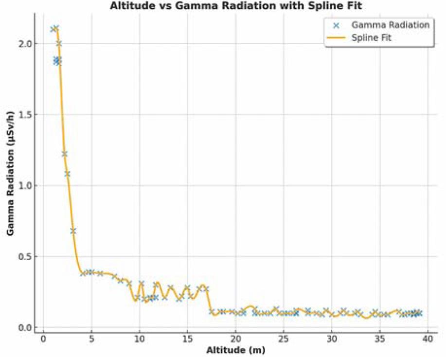
Altitude vs. gamma radiation intensity. The graph demonstrates inverse correlation between altitude and gamma radiation intensity. At altitudes above approx. 10 m, the data exhibit increased noise, and radiation resolution drops.
UAV gamma radiation data collected via the GammaRAE II R dosimeter were plotted over aerial image to visualize the radioactivity distribution (Fig. 2). The uneven distribution of the measured points is given by manual flightpath without pre-programmed waypoints.

Visualization of the radioactivity distribution as measured with the UAV. Each dot represents a measurement point recorded by UAV, with the color indicating the intensity of the measured gamma radiation (μSv/h). Imagery: CNES/Landsat/Copernicus (2023).
Each point represents a measurement, with color indicating the intensity of the measured gamma radiation (μSv/h). The plotted gamma radiation measurements were corrected for altitude error (Fig. 3) using the inverse-square law, which governs the attenuation of radiation with distance from the source. Since gamma radiation intensity diminishes with the square of the distance, a correction factor was applied to each recorded value. It is calculated using the following formula:
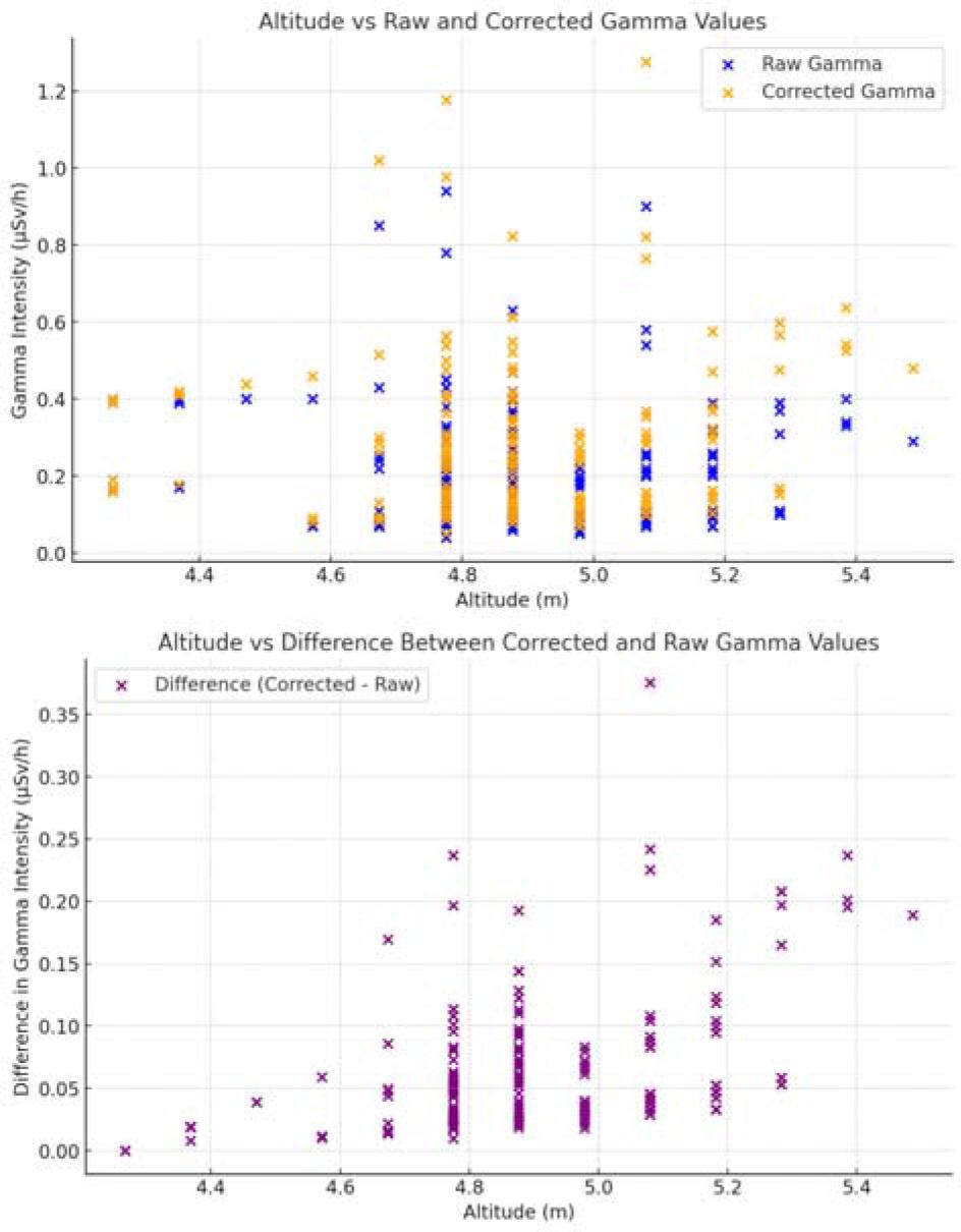
Relationship between raw and altitude corrected gamma radiation values. The upper graph displays the relationship between altitude, raw gamma values, and corrected gamma values after normalization to the lowest altitude, demonstrating how altitude correction impacts the data. The second graph shows the difference between corrected and raw gamma values, highlighting the extent of the correction applied across the dataset.
To visualize the spatial distribution of corrected gamma radiation across the entire survey area, an interpolated map was generated using the inverse distance weighting (IDW) method (Fig. 4). Interpolation technique estimates gamma radiation levels at unsampled locations and is commonly used in geostatistical practices for radiation surveys [9, 10]. However, in this study, the density of measured data points across the area is relatively low, which means relying solely on interpolated values could lead to potential overinterpretation of the spatial distribution. Therefore, the interpolated map serves as an estimation rather than a definitive representation of radiation levels in unsampled regions.

Interpolated map of gamma radiation. Black markers represent interpolated values, with size proportional to gamma levels, while colored points show actual measurements, illustrating the relationship between estimated and real data.
The IDW-interpolated gamma data were visualized as a relative values heat map. In this representation, uniformly distributed black markers were plotted on a grid, with each marker’s size proportional to the interpolated gamma value. Areas with lower gamma radiation appeared brighter due to the smaller size of the markers, while areas with higher gamma values appeared darker, as larger markers created a more pronounced black coloration. This technique allowed for a clear visual distinction between areas of varying radiation levels, emphasizing the spatial trends in the interpolated data.
To further highlight the relationship between measured and interpolated values, a layer of actual measurement points was overlaid onto the heat map. These measured points were displayed in various colors according to a color bar that corresponded to the real gamma radiation values. By juxtaposing the interpolated heat map with actual measurement data, this approach clearly conveyed that the interpolated values provide an estimate of spatial distribution but may not precisely reflect the real gamma levels in all areas. This combination of visualization techniques ensures clarity in the representation of both estimated and measured values, following established practices in geostatistics and environmental radiation monitoring [9, 10].
To identify areas of elevated gamma radiation, we conducted a Z-score analysis on the collected data (Fig. 5). Z-scores quantify how many standard deviations a particular data point is from the mean, offering a method to assess the anomaly of radiation levels relative to the overall dataset [11, 12]. It is calculated using following formula:
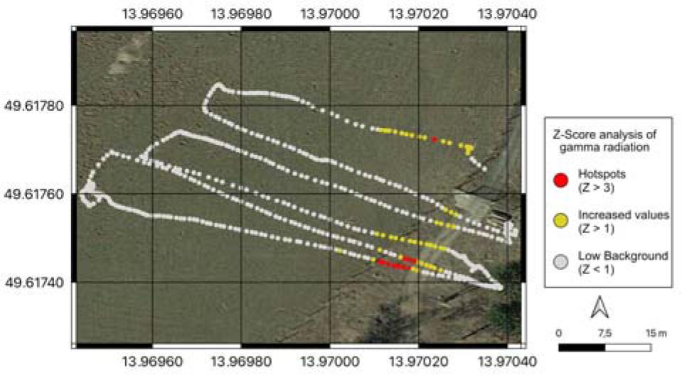
The hotspot analysis identified locations where the gamma radiation levels are significantly higher than the surrounding area, with Z-scores greater than 3. These are considered potential hotspots, and they are highlighted in red on the map. Data points with Z-scores greater than 1 are shown in yellow. Imagery: CNES/Landsat/Copernicus (2023).
Locations where the Z-score exceeded 3 were flagged as potential hotspots, indicating significantly higher gamma radiation levels compared to the rest of the dataset. Z-scores above 3 represent data points that are more than three standard deviations from the mean, corresponding to the top 1.83% of values in our dataset. These data points are considered significant anomalies, or “hotspots”, where gamma radiation levels are notably higher and warrant further investigation [11]. Z-scores above 1 were used to highlight areas with increased radiation, though these values remained within a broader range of natural variability. A Z-score above 1 represents data points that are more than one standard deviation from the mean, which captures the top 11% of values in our dataset. While these areas may exhibit slightly elevated radiation, they are generally considered minor deviations and are not necessarily indicative of substantial concern [13].
The UAV-based survey successfully collected 600 data points, revealing spatial variations in gamma radiation across the Třebsko site (Fig. 2). Analysis of the vertical profile (Fig. 1) demonstrated a relationship between altitude and measured gamma radiation intensity, closely aligning with the inverse-square law, where radiation levels decrease with the square of the distance from the ground [6]. This result underscores the critical importance of maintaining a consistent altitude during surveys, providing a robust framework for applying altitude corrections in future investigations.
The altitude measurements during the survey showed good consistency, with an average of 4.9 m AGL, ranging from a minimum of 4.2 m to a maximum of 5.4 m (Fig. 3). These altitude measurements were obtained using the barometric sensor on the UAV, which has a typical accuracy of ±0.5 m. The altitude correction process successfully normalized the radiation measurements to a consistent reference height, improving data comparability across the survey area.
The spatial distribution of radiation was visualized through an interpolated map (Fig. 4), revealing distinct patterns in radiation distribution. Peak radioactivity values reached as high as 0.94 μSv/h (raw measured) and 1.276 μSv/h (low altitude normalized), likely corresponding to geological formations rich in naturally occurring radioactive materials (NORMs), such as thorium and uranium [14]. The interpolated map effectively highlighted areas of varying radiation intensity, though the relatively low density of measurement points necessitated careful interpretation of interpolated values between measured locations.
Z-score analysis pinpointed 11 points where radiation levels significantly exceeded those of the surrounding areas (Z-score > 3), with the majority of these potential hotspots concentrated in the southern and central regions (Fig. 5). Notably, these anomalies exhibited a strong correlation with those identified in previous high-resolution surveys [2]. Further comparison between detailed land survey and our low-cost rapid survey is shown in Fig. 6.
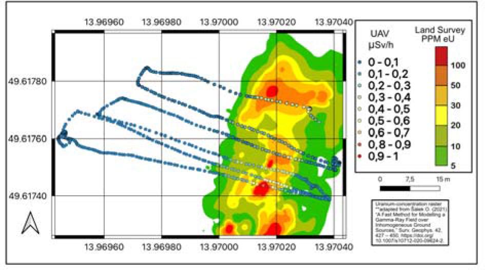
Comparison between the rapid UAV survey and a professional-grade land survey. Land survey map was adapted from Sálek [15].
The UAV system performed reliably throughout the survey, maintaining a stable flight path and consistently logging data. The total survey duration, including preflight setup, was approx. 20 min, during which we were able to collect 600 data points along approx. 450 m of flight profiles, covering a total surveyed area of about 350 m2. This efficiency demonstrates the system’s potential for rapid environmental assessments. Overall, these findings demonstrate that even a consumer-grade UAV platform can provide valuable preliminary data for gamma radiation mapping, offering a feasible solution for rapid environmental assessments and emergency response scenarios.
This study evaluated the performance of a low-cost UAV-based system for gamma radiation monitoring, comparing it to professional-grade airborne spectrometry systems. While professional systems provide superior sensitivity and spatial resolution due to their large-volume detectors and advanced UAVs, they are costly, require specialized expertise, and involve extensive logistical preparations, making them less accessible for smaller organizations or rapid-response scenarios [16, 17]. In contrast, our low-cost (<1500 USD) UAV system, equipped with the GammaRAE II R dosimeter, demonstrated the ability to detect significant radiation anomalies and map broad spatial patterns of gamma radiation with reasonable accuracy. Although our system’s detection limit of 0.05 μSv/h is lower than that of professional-grade systems, it proved sufficient for identifying radiation hotspots.
One key limitation of our system is its lack of spectral data, which prevents the identification of specific radionuclides. Professional-grade systems often provide spectral information that allows for distinguishing between natural and artificial radiation sources and for identifying specific isotopes, which is critical in applications such as nuclear incident response or detailed geological studies. Without this capability, our system is limited to measuring overall radiation levels without distinguishing the sources, which may reduce its utility in more nuanced environmental assessments. However, for rapid, preliminary surveys where identifying broad areas of increased radiation is the primary goal, this limitation does not significantly impact the system’s effectiveness.
The primary advantage of this system lies in its affordability and rapid deployment. At a fraction of the cost of professional systems, our UAV system provides a practical solution for situations where budget constraints or quick deployment are critical, such as in emergency response scenarios. Its ability to be operational within minutes is particularly valuable for nuclear accidents or radiological emergencies, where immediate assessments are required. UAV-based systems like ours offer a flexible alternative for monitoring remote or dangerous areas, improving safety and accessibility in radiation monitoring [18]. Despite its lower sensitivity and lack of spectral data, our system demonstrated strong correlations with previous high-resolution surveys conducted at the Třebsko site by Šálek [2]. The detected hotspots based on Z-scores reflect areas with relatively elevated radiation levels, but it is important to note that these anomalies do not necessarily indicate harmful radiation. Instead, their significance lies in their deviation from the local mean, and further investigation would be needed to assess any real risk, in line with regulatory thresholds [14, 19].
While our system cannot fully replace high-resolution professional systems for detailed geological or environmental studies, it offers a valuable complementary tool for initial assessments and frequent monitoring. The continued evolution of consumer-grade UAV technology offers future possibilities for improving flight time, accuracy, and sensitivity. Integrating lightweight, more advanced detectors, such as compact gamma spectrometers, could enhance the system’s performance and address the current lack of spectral resolution. By balancing cost, accessibility, and performance, our system addresses the growing need for affordable, rapidly deployable radiation monitoring solutions in a wide range of fields.
This study demonstrates that a low-cost UAV-based system can be effectively applied for rapid gamma radiation surveys. Using a consumer-grade DJI Phantom 2 equipped with a GammaRAE II R dosimeter, we collected 600 data points across ~350 m2, with a total of 450 m of flight profiles. The system successfully detected spatial variations and highlighted radiation anomalies consistent with previously reported surveys.
Despite lower sensitivity and the absence of spectral resolution compared to professional-grade airborne systems, the UAV approach provides sufficient accuracy for preliminary assessments. Its affordability, portability, and rapid deployment make it particularly suitable for emergency response, environmental monitoring, and educational purposes.
The results confirm that consumer UAVs combined with accessible detectors and open-source analysis tools can fill an important gap between high-cost professional systems and the need for fast, affordable radiation monitoring solutions. With continuing advances in UAV and sensor technology, future upgrades may further enhance performance and broaden applications of this approach.