
The study described here aims to better understand the role of colonial heritage in African cities today, several decades after the decolonisation of the continent. Ghana and its colonial castles and forts were selected as a case study due to their abundance within the country’s borders and the diversity of strategies for their preservation and adaptation to new uses. The complex situation in Ghana illustrates how varied the perspectives on European heritage can be in countries once occupied by European powers. Many of the ways in which Ghanaians engage with Afro-European heritage can also be observed in other African countries. The case study presented here can serve as a lens for examining colonial forts more broadly across the African continent, both through the insights gained from the study and the research methodology employed.
Academic literature has dedicated a lot of space to the history of European settlements on the Gold Coast (see, for example: Feinberg 1989; DeCorse 1992, 2001; Hansen 2002; Valsecchi 2011; Ipsen 2015), as well as to commercial forts built there from the fifteenth to the nineteenth century (Ephson 1970; van Dantzig 1980; Anquandah 1999; St Clair 2007; DeCorse 2010; eds Osei-Tutu & Smith 2017; Osei-Tutu 2018 – to name just a few). Due to the presence of gold, which had been sourced from the region for centuries, and which used to reach Europe through the Sahara before the age of great geographical discoveries, capturing the imagination on the Old Continent, this area has been of particular interest to almost all European colonial empires, as each emerged, since the fifteenth century. These included the Portuguese, Dutch, Danish, Swedish, British and even the Brandenburgers, whose installations were eventually transferred to Prussian control. Because of the uniqueness of the Gold Coast at that time, which eventually became attractive also – perhaps mainly – due to the slave trade (Rodney 1969), contemporary researchers have dedicated a lot of time investigating the history of the European presence in the region. They frequently focused on specific empires, such as the Portuguese (Vogt 1979), the Danish (Nørregård 1966; Weiss 2013), the Brandenburg-Prussian (Zaugg 2018), the Dutch (Feinberg 1974; Baesjou 1979; Postma 1990) and the British (Law 2001; Peterson 2010; Shumway 2014; Biveridge 2018), as well as the rivalry between them (Nathan 1904; da Silva 2011).
However, contemporary academic studies tackle the fate and methods of using this material colonial heritage, related to the period after Ghana proclaimed independence in 1957, much less frequently (with the few examples being: Ephson 1970; Finley 2004; Reed 2004; MacGonagle 2006; Hove 2017). Typically, analyses pertaining to this period focus on the functions, usage and development of the fortifications for tourism (see: Bruner 1996; Essah 2001; Richards 2005; Agyei-Mensah 2006; Addo 2011; Mensah 2015; Mowatt & Chancellor 2011; Reed 2016; Boateng et al. 2018; Siakwah 2018). However, the large number of such analyses gives rise to the erroneous belief that the tourist functions have dominated these sites, especially since the majority of forts were included on the UNESCO List in 1979. The reality is much more complex. Presenting this complexity is one of the main objectives of this text.
Furthermore, the place these fortifications occupy in the contemporary spatial and functional structure of the villages, towns and cities of Ghana has been omitted, to the best of our knowledge. It is important to analyse this issue since urbanisation pressure on monuments in African cities is increasing, while decision-makers and residents are currently facing numerous problems associated with this pressure.
In this context, our article has two main objectives. The first is to query the functions that are currently fulfilled by colonial forts, previously built by Europeans, on the section of the Atlantic coast that is, nowadays, within the borders of Ghana. The second is spatial (strictly geographical) in nature and consists in identifying the place these forts occupy in the contemporary spatial and functional structure of settlements or cities where they are located. Achieving both goals will serve to identify the place and role of the forts within the dynamically developing space. It should be noted that urbanisation is one of the most profound transformations that the African continent will undergo in the twenty-first century (AfDB 2022). This is no different for Ghana, where urbanisation processes have considerably intensified over the last two decades (Adarkwa 2012; Cobbinah & Erdiaw-Kwasie 2018). In Ghana, this affects not only main urban centres, such as Accra or Cape Coast, but also smaller towns, where urbanisation, in demographic terms, is clearly taking place.
Analysing the role and place of monuments in such a dynamic environment is an interesting issue within a supra-local context, associated with more than just Ghana itself. European fortifications were erected along the entire African coast, from Morocco to South Africa and from Senegal in the West to Kenya in the East. Many of these sites are experiencing spatial, functional, environmental and economic pressure, similar to that of the forts and castles in Ghana.
Therefore, we believe our text also contributes to the discussion on the role of material colonial heritage in African cities and beyond. This discussion has been ongoing in the academic world for years, and shows the complexity of the issue in Africa (see for example: Sarmento 2016; Górny 2023) and beyond: wherever Europeans built their fortifications – for example, in North America (Pendery 2010; Lightfoot 2019), the Caribbean (Deagan 2010; Harris 2010; Haviser 2010), South America (Hefting 2010; Czerny 2018) and Asia (Verdejo et al. 2014).
It should also be noted that residents’ attitudes towards the difficult heritage left by Europeans is not the same throughout Africa as it is in Ghana, where many post-European fortifications are subject to national and international protection. For example, while Fort Jesus in Nairobi or Kuntha Kinte Island in Gambia are, nowadays, museums, and included on the UNESCO List (Linehan & Sarmento 2011; Bellagamba 2009), forts in Guinea-Bissau (in Bissau itself and Cacheu), for instance, currently fulfil other functions and are not subject to extensive protection (Temudo 2012; Górny & Górna 2022).
Currently, decisions regarding the functions to be assigned to material heritage sites from the era of European colonialism in Africa, and whether to protect this heritage, are made by Africans themselves, for whom the heritage holds very different meanings. It is frequently described as “difficult heritage”, “problematic heritage”, “heritage of atrocity”, “unwanted heritage” or “preexisting heritage” (see: Górny 2023, pp. 13–16). The related debate is also ongoing in Ghana; however, here, by means of inscription on the UNESCO List as early as 1979, an attempt was made to protect the heritage collectively, covering it with a supra-state form of protection. The aim of this text is to illustrate how this specific case study provides new insights into the ongoing debate about colonial legacies in Ghana and other locations.
The research process was divided into two stages. The first involved conducting field research in Ghana in August 2022. During the research, 24 sites were visited (see figure 1 and table 1). Extensive photographic documentation of both the sites themselves and the space around them was collected at each fortress. Where it was possible to do so, a guided tour with a local guide or site employee was arranged. At certain sites, this form of tour was obligatory (e.g. Cape Coast Castle or Elmina Castle); at others, it was optional (e.g. Fort Batenstein in Butre), while in some, it was unavailable (Fort Victoria in Cape Coast). Some of the sites are completely closed off to tourists nowadays (e.g. Fort Orange in Sekondi or Fort James in Accra). However, research was also successfully carried out there upon making prior arrangement with administrators, employees, residents or custodians.
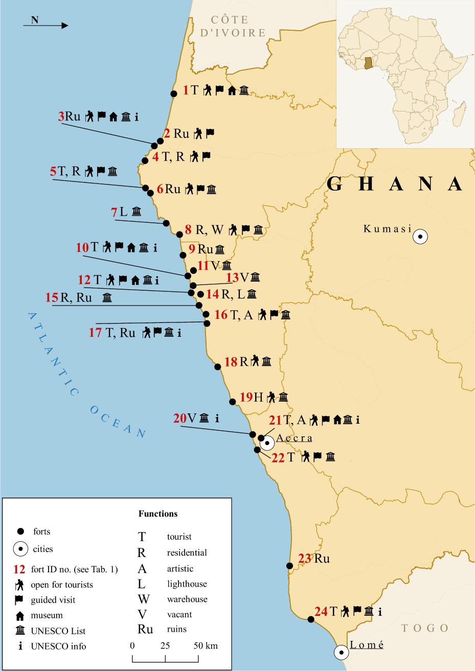
Location, features and functions of colonial forts on the coast of Ghana
Source: own elaboration
Information on the accessibility of the analysed forts, their functions and entry on the UNESCO List
| Item | Name of the fort (from West to East along the coast of Ghana) | Accessible to tourists | Entry fee per person (in cedi) | Guided tour | Fort museum | Contemporary function | On UNESCO List | Info on UNESCO on site |
|---|---|---|---|---|---|---|---|---|
| 1 | Fort Apollonia | YES | 30 | YES | YES | tourist | YES | NO |
| 2 | Fort Elize Carthago | YES | 10 | YES | NO | ruins, none | NO | - |
| 3 | Fort Saint Anthony | YES | 50 | YES | YES | tourist | YES | YES |
| 4 | Fort Groß Fredericksburg | YES | 20 | YES | NO | tourist, residential | YES | NO |
| 5 | Fort Metal Cross | YES | 20 | YES | NO | tourist, residential | YES | NO |
| 6 | Fort Batenstein | YES | (fee for the village) | YES | NO | ruins, none | YES | NO |
| 7 | Fort Orange | NO | - | - | NO | lighthouse | YES | NO |
| 8 | Fort São Sebastião | YES | 10 | YES | NO | residential, storage, meeting place | YES | NO |
| 9 | Fort Komenda | NO | - | - | NO | ruins, none | YES | NO |
| 10 | Elmina Castle | YES | 50 | YES | YES | tourist | YES | YES |
| 11 | Fort Coenraadsburg/Fort St. Jago | NO | - | - | NO | vacant building | YES | NO |
| 12 | Cape Coast Castle | YES | 50 | YES | YES | tourist | YES | YES |
| 13 | Fort Victoria | NO | - | - | NO | vacant building | YES | NO |
| 14 | Fort William (formerly Smith’s Tower) | NO | - | - | NO | residential, lighthouse | YES | NO |
| 15 | Fort Nassau | NO | - | - | NO | remains of ruins, residential | YES | NO |
| 16 | Fort William | YES | 50 | YES | NO | tourist, artistic | YES | NO |
| 17 | Fort Amsterdam | YES | 10 | YES | NO | tourist, ruins | YES | YES |
| 18 | Fort Patience | YES | 10 | NO | NO | residential | YES | NO |
| 19 | Fort Goede Hoop | YES | 10 | NO | NO | hotel, residential, commercial | YES | NO |
| 20 | Fort James | NO | - | - | NO | vacant building | YES | YES |
| 21 | Ussher Fort | YES | 50 | YES | YES | tourist, artistic | YES | YES |
| 22 | Osu Castle | YES | 40 | YES | NO | tourist | YES | NO |
| 23 | Fort Kongensten | NO | - | - | NO | remains of ruins, none | NO | - |
| 24 | Fort Prinzenstein | YES | 25 | YES | YES | tourist | YES | NO |
Source: own elaboration.
During the field research, particular attention was paid to the following issues: accessibility to tourists, the option to see the location with a guide, visibility of information about inclusion of the fort on the UNESCO World Heritage List (22 out of 24 of the facilities visited during the research are included on the list), potential entry fee, as well as – most importantly – the function a given fort fulfils nowadays. During the visit, detailed field notes were taken at each site. Wherever it was possible, unstructured interviews were also conducted with guides, building custodians, ticket vendors, fortress residents (some of those fortresses are houses) or tourist information centre employees. These conversations were free-flowing and aimed at obtaining information about the broader context concerning the contemporary functioning of the sites, their owners, and any institutions that may be housed there.
The second stage involved developing maps depicting the analysed forts in a broader spatial and functional context. Apart from the location of the fort itself, the maps also show the immediate surroundings – namely, nearby buildings, their functions, and the degree to which the fort has “blended in” with the urban tissue, its exposure on a hill, and so on. The foundation used for drawing up the maps consisted of satellite images available from Google Earth Pro, which is an effective source for this type of analysis; information about space usage, contained in OpenStreetMap; as well as photographic documentation, collected during the field research.
This way, a contemporary functional and spatial depiction of the analysed forts was obtained, as discussed below.
Among the 24 analysed forts, 15 were available for sightseeing to interested parties (table 1). All of these sites charge an entry fee. The price ranges from 10 to 50 cedi (GH₵). At certain sites, where the price is above 30 cedi, it includes a tour of the museum inside the fort. Organised exhibitions in the form of museums can only be found in six forts. Fourteen sites can or have to be toured while accompanied by a guide (included in the price). In certain cases, tipping the guide was also suggested. Thirteen sites (more than half of them) do not fulfil a tourist function or the tourist function is not the main one.
In 1979, UNESCO entered “Forts and Castles, Volta, Greater Accra, Central and Western Regions” on the World Heritage List (UNESCO 1979). The organisation states that the entry covers facilities that are classified into five groups (UNESCO 2024):
three castles (in Accra, Elmina and Cape Coast);
fourteen well-preserved forts;
four forts, partially in ruins (in Abandze, British Komenda, Butre and Keta);
five forts with ruins with visible structures (in Mouri, Old Ningo, Dutch Komenda, Prampram and Akwida);
two locations with traces of former fortifications (Frederiksborg in Cape Coast and Augustaborg in Accra).
The research described herein covers all sites from groups 1, 2 and 3, as well as one from group 4 – Fort Nassau at Mouri. Therefore, the analysis covers 24 sites in total: 22 out of 28 sites that are included on the UNESCO List, and two sites not listed there.
It should be noted in particular that two of the analysed sites are not included on the List. The first is the remains of Fort Elize Carthago (figure 2), established by the Dutch in 1702, and lies near the mouth of the Ankobra River on the Atlantic coast (Marshall 2021). The site comprises the foundations of a former fort, covered by a thick forest and located on a plot of land that belongs to the German owner of a nearby hotel, Ankobra Beach Resort. Thus, the monument is private property and, so far, no measures have been taken to prevent its further degradation. The second site is Fort Kongensten, founded by the Danish in 1783, and located in the town of Ada in the western part of the country. The site has been almost completely destroyed as a result of the continuously rising sea level, although archaeological works, resulting in numerous discoveries, have been conducted there over the past few years (Aryee & Apoh 2018). In our opinion, the remaining ruins of the two aforementioned forts should be immediately added to the 1979 entry; these sites are currently in danger of being completely obliterated.
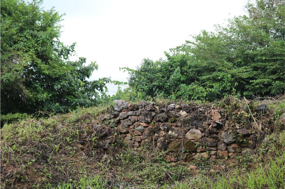
The remaining ruins of Fort Elize Carthago near the Ankobra River mouth, without any protection and not included on the UNESCO List
Source: Authors’ photography, August 2022
The original function of the majority of the analysed sites was trade – first, this was in gold; then, the primary focus gradually shifted to the slave trade, in which all European empires that owned land in Africa between the fifteenth and the nineteenth century, without exception, participated to some extent. These sites were established for the purpose of trade in gold and slaves, and were – in part – defensive forts. However, from 1807, a ban on slave trading was gradually introduced for citizens of Great Britain (Berlin 2003), which established the Gold Coast colony in 1821 on the Gulf of Guinea. Officially, around 1865, the slave trade was legally prohibited across the land and at sea throughout the empire (Morgan 2007). As a result of the abolishment of slavery, forts had to be assigned new functions. In some cases, they were completely abandoned and, in extreme instances, they were dismantled to reuse the raw materials. During the nineteenth century, the functions of the forts changed completely (van Dantzig 1980). Prior to the decolonisation of the Gold Coast, the British – and, earlier, the Dutch and the Danish – utilised these relics of the bygone era in various manners. Initially, some of them continued to fulfil military and defensive functions – for example, against the attacks by Africans from the interior during the Anglo-Ashanti wars in 1823–1900. Over time, the military function became the leading one for the majority of the sites, which served as resource bases for the war waged in the interior – as warehouses, barracks or reloading stations. It was then also that the last group of forts, which were supposed to protect larger facilities, was established – for example, two of the sites covered by the analysis, located in Cape Coast, namely Fort Victoria (built in 1820 as Phipps’ Tower) and Fort William (1821).
In 1872, when the Dutch withdrew from the Gold Coast, all forts on the coast were ultimately taken over by the British. By the end of the century, the war with Ashanti and the conquest of the interior up to the borders, as determined at the Berlin Conference (1884/85), had ceased. It was then that most forts also lost their military functions and needed “a new purpose”. For example, Fort Coenraadsburg in Elmina and Fort James in Accra were transformed into prisons. Some of the sites were abandoned and, over time, settled by the local population that frequently built additional facilities there (van Dantzig 1980). However, many sites fell into disrepair. They remained in this state until the early 1950s, when these sites began to be seen as monuments deserving protection – thanks to the works of O’Neil (1951) for the Ghana Museum and Monuments Board, and a publication edited by Fage (1959) containing a list of forts, prepared for the Ghana Survey Department, followed by a publication by Lawrence (1963).
Upon the formal decolonisation of Ghana in 1957, the administration of all European fortifications along its 539 km-long coast was handed over to the new African authorities. This was another crucial game-changer in their usage. At the time, some of these sites were in a sufficiently good state, so their further use for various purposes continued. During the period between gaining independence and the field research described herein (1957–2022), these sites fulfilled a number of functions. For instance, Fort James in Accra, where Nkrumah himself was detained in 1951, remained a prison until the end of 2008, and was later turned into a museum. The Osu Castle in Accra, which had been the office of the British governor, remained the seat of subsequent presidents until 2013, including that of Jerry Rawlings (Engmann 2021). Some fortifications were turned into museums immediately or soon after decolonisation – for example, the castle in Elmina (the museum opened in 1972) (Bruku 2015; Womber 2020). Other sites were abandoned right away or over time and fell into further disrepair. Many of them, especially the most damaged ones, only gained attention after their inclusion on the UNESCO List in 1979. In his inventory of forts and castles of Ghana from 1980, Albert van Denzing mentions the functions fulfilled at that time by some of the sites we analysed:
- -
five were described as ruins or with few traces (Fort Kongensten, Fort Amsterdam, Fort Nassau, Fort Komenda, Elize Carthago);
- -
four were prisons at the time (Fort James, Ussher Fort, Fort William in Anomabu, Fort Prinzenstein);
- -
three served as resthouses (Fort Apollonia, Fort Metal Cross, Fort Patience);
- -
two were, at the time, under reconstruction (Fort Goede Hoop, Fort Batenstein);
- -
two had been adapted as a post office and government office (Fort Saint Anthony, Fort São Sebastião);
- -
Fort Groß Fredericksburg served as a “residence for nurses of the German hospital”;
- -
Fort Orange served as “offices of Ghana Railway and Port Authority, lighthouse”;
- -
Cape Coast Castle already housed the West African Historical Museum at the time;
- -
Osu Castle was the seat of government (van Dantzig 1980).
Therefore, it would be worthwhile to examine their modern-day functions and compare them with those from previous years, immediately after Ghana gained independence.
For 11 out of the 24 analysed sites, tourism is currently the leading function. In the case of the most recognisable sites, such as the three aforementioned castles in Elmina, Cape Coast and Accra, this function is clear and generates financial profits on a daily basis. These sites generate income themselves and are recognisable brands on the market, especially as “heritage tourism” or “roots tourism” sites (Mensah 2015). They are regularly visited by scores of tourists from all over the world, while visitors frequently have access to souvenir shops, museums or tour guide services on site. The castles in Elmina and Cape Coast are often venues for “concerts, religious events, workshops and exhibits” (Lundt 2022, p. 123). Some of the tourist sites – for example, Fort Amsterdam in Abandze – are available for sightseeing purposes, but this fort is only opened after calling its custodian, who arrives, upon request, with the keys and takes interested individuals on a tour.
One of the sites currently serves as a hotel for tourists – Fort Goede Hoop in Senya Beraku, which is owned and administered by a German citizen who also lives in that facility and runs a shop there.
Importantly, as many as seven sites fulfil a residential function. These are forts intended exclusively for this role (Fort Nassau, Fort Patience) or that fulfil it in addition to another purpose (Fort Groß Fredericksburg, Fort Metal Cross, Fort São Sebastião and the aforementioned Fort Goede Hoop, as well as Fort William – formerly Smith’s Tower). The latter is simultaneously a lighthouse, just like Fort Orange in Sekondi-Takoradi, which fulfilled this sole function at the time of this research, although maintenance works were being carried out there. According to the construction workers, with whom an interview was conducted, the works had been commissioned by one of the governmental institutions and were aimed at preparing Fort Orange for tourists. Thus, another change of the site’s function can be anticipated in the near future.
Two of the analysed forts – namely, Fort William in Anomabu and Ussher Fort in Accra – fulfil an artistic as well as a tourist function. In the former, crafts workshops for women from the local community were taking place at the time of the research, while in the other, a large format painting festival was taking place (figure 3). Ussher Fort is periodically the venue of various festivals. On the other hand, Fort São Sebastião in Shama, inhabited by two families (residential function), also houses a warehouse, in which – according to its residents – voting cards used in previous elections are stored under lock and key on the fourth floor. According to the local guide, it also serves as a meeting place for the local youth.
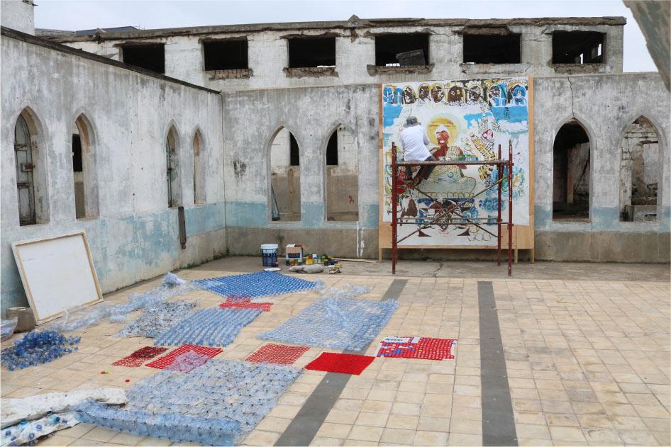
An artist working on a painting in Ussher Fort in Accra
Source: Authors’ photography, August 2022
As many as six forts are currently ruins (e.g. Fort Batenstein in Butre), while three other (e.g. Fort James in Accra), albeit well preserved, are nowadays abandoned and waiting for a new purpose.
When examining the numerous functions of the analysed sites, as well as their various changes – both historically and contemporarily – post-colonial forts can hardly be considered constant, immutable components of the spatial and functional structure. On the contrary, they are likely to undergo transformations in terms of ownership and control by individual actors – local authorities, private entrepreneurs or the local population. Their role changes over time, depending on the social and economic or political situation, both local and nationwide (see Ussher Fort in Accra), and on access to funds to allow for their renovation and the development of the tourist function. Due to the lack of such funds, some of the analysed sites have fallen into disrepair, successively losing their position and previous role in the spatial and functional structure of the analysed settlement units (e.g. Fort Nassau in Moree or Fort Batenstein in Butre).
Out of the 24 analysed forts, the overwhelming majority (13) are located in towns (T), namely small urban settlement units. Seven sites are located within the cities (C) of Accra, Sekondi-Takoradi and Cape Coast, which are simultaneously among the ten largest metropolitan areas in Ghana. Only three forts are located in villages (V) without urban features. In the case of one of the sites, it was impossible to indicate the status of the locality where it is situated. The site in question is Fort Elize Carthago, the ruins of which are barely visible in the terrain and are located in a forest at the mouth of the Ankobra River, far from any buildings.
A crucial component of the conducted research is to indicate not only the location of the forts and the locality status but also their placement within the specified settlement units. The analysis took into account the following criteria: location – by the sea (S) or inland (I), landform – flat (F) or a hill (H), surroundings – surrounded by buildings (B) or by forest (F). Determining individual attributes of the locations of the forts allowed for more precise identification of their position in the settlement tissue.
The majority of the analysed sites are located directly on the coast (15) (see, for instance, Fort Metal Cross, figure 4; or Fort Groß Fredericksburg, figure 5). They are much more prone to degradation as a result of the erosive effect of the sea. We already know examples of forts that have been destroyed by sea waves, leaving only ruins (e.g. Fort Kongensten in Ada Foah). The remaining nine sites are located inland, so the causes that may lead to their degradation primarily include urbanisation pressure, meteorological factors, mass waste, uncontrolled spread of vegetation, as well as devastation of buildings by the local population (see, for instance, Fort Batenstein, figure 6; or Fort Komenda, figure 7).
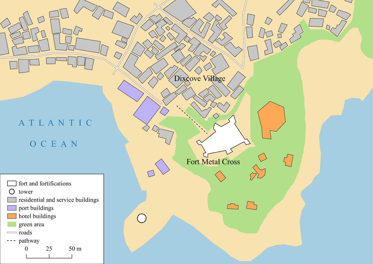
The location of Fort Metal Cross in Dixcove village
Source: own elaboration
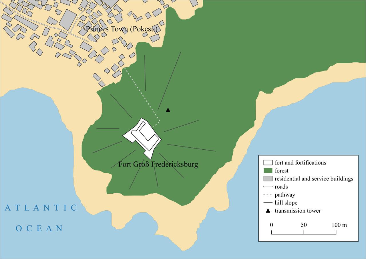
The location of Fort Groß Fredericksburg in Pokesu town
Source: own elaboration
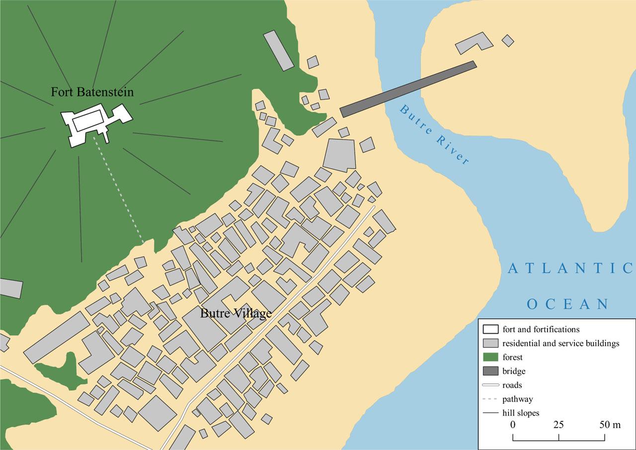
The location of Fort Batenstein in Butre Village
Source: own elaboration
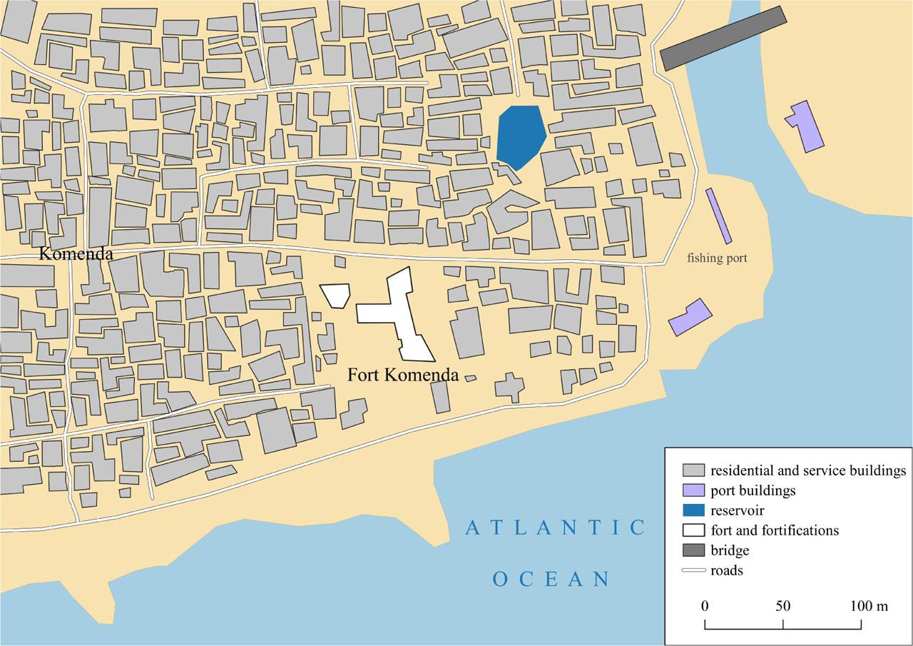
The location of Fort Komenda in Komenda town
Source: own elaboration
The terrain has a significant impact on the process of deterioration of the forts on the one hand, and on their exposure within the landscape on the other. Fourteen of the analysed sites are situated on flat terrain, which means they are much more accessible. Reaching them by car or on foot is not a challenge, which can make tourist traffic easier. On the other hand, these sites are simultaneously the most prone to urbanisation pressure. An example of a fort located on flat terrain, which has been partially destroyed and absorbed by informal architecture, is Fort Komenda. The ten remaining sites, due to their location on hills, tower over the buildings or the coast as a clear dominant point in the landscape. Although they are better exposed, they are less accessible and frequently endangered by mass waste that occurs on hill slopes (see, for instance, Fort Groß Fredericksburg, figure 5; Fort Batenstein, figure 6; or Fort Coenraadsburg, figure 8).
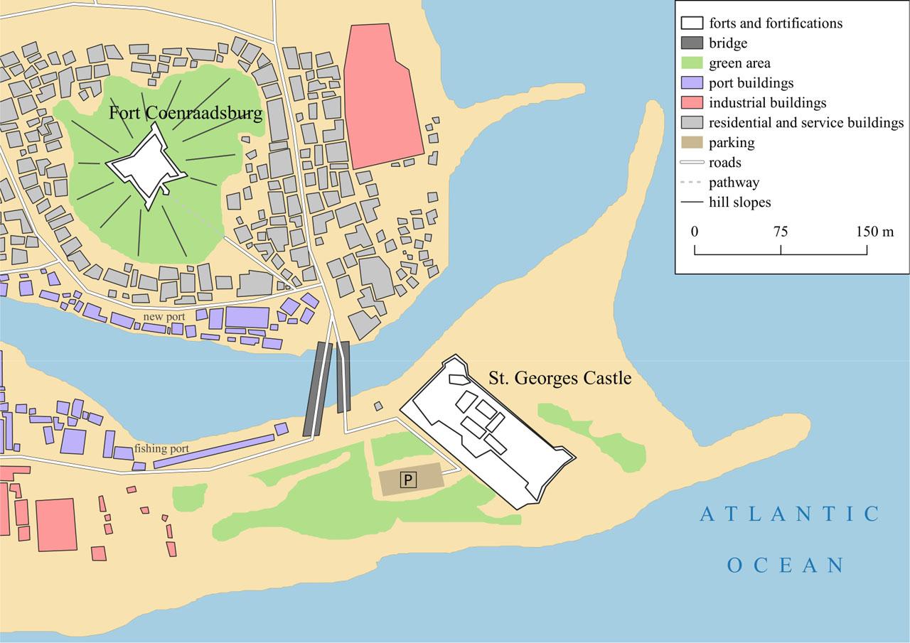
Neighbouring Elmina Castle and Fort Coenraadsburg in Elmina town
Source: own elaboration
A clear majority of all analysed forts (20) are surrounded by dense architecture (B). These sites are, on the one hand, subject to urbanisation pressure, and, on the other, well integrated into the settlement tissue, which makes them an important part of the landscape (see, for instance, Fort Komenda, figure 7). Typically, forts surrounded by buildings (residential, service, commercial, etc.) also play a more important role in the spatial and functional structure. It should also be emphasised that the forts themselves frequently played a settlement-forming role, with cities, towns or villages growing around them. Three of the analysed sites are surrounded by dense forest (F), limiting their accessibility to potential tourists (see, for instance, Fort Groß Fredericksburg, figure 5; or Fort Batenstein, figure 6). The location of one of the analysed sites – Fort Kongensten in Ada Foah – did not fit either of the two categories of surroundings (B or F). It comprises ruins that were surrounded by farmland but have been almost completely claimed by the sea.
Six types of forts were defined based on the discussed criteria – location, landform and surroundings – in order to classify the analysed sites (table 2). The analysis excluded the aforementioned (almost no longer existing) Fort Kongensten in Ada Foah. The most numerous type of fort was type 2 – SFB (by the Sea, with Flat landform, surrounded by Buildings). Nine sites – located on the coast, with flat land and surrounded by buildings – were classified in this category. Although these forts can be the most prone to urbanisation pressure due to their situation on flat land on the coast, they are simultaneously highly accessible to tourists, for example, and offer auxiliary infrastructure; this gives them the highest potential for the development of tourism among the analysed sites. It should be emphasised that among the nine forts classified as type 2, as many as seven fulfil a tourist function.
Information on the location and surroundings of the forts
| Item | Name of the fort | Locality | Locality status (C – city, T – town, V – village) | Location (S – by the sea, I – inland) | Landform (F – flat, H – hill) | Surroundings (B – buildings, F – forest) | Types: 1 IFB/2 SFB/3 IHF/4 IHB/5 SHF/6 SHB |
|---|---|---|---|---|---|---|---|
| 1 | Fort Apollonia | Beyin | V | I | F | B | 1 |
| 2 | Fort Elize Carthago | Ankobra river mouth | - | S | H | F | 5 almost no traces |
| 3 | Fort Saint Anthony | Axim | T | S | H | B | 6 |
| 4 | Fort Groß Fredericksburg | Princes Town (Pokesu) | T | S | H | F | 5 |
| 5 | Fort Metal Cross | Dixcove | V | S | H | B | 6 |
| 6 | Fort Batenstein | Butre | V | I | H | F | 3 |
| 7 | Fort Orange | Sekondi-Takoradi | C | I | H | B | 4 |
| 8 | Fort São Sebastião | Shama | T | I | F | B | 1 |
| 9 | Fort Komenda | Komenda | T | I | F | B | 1 |
| 10 | Elmina Castle | Elmina | T | S | F | B | 2 |
| 11 | Fort Coenraadsburg/Fort St. Jago | Elmina | T | I | H | B | 4 |
| 12 | Cape Coast Castle | Cape Coast | C | S | F | B | 2 |
| 13 | Fort Victoria | Cape Coast | C | I | H | B | 4 |
| 14 | Fort William (formerly Smith’s Tower) | Cape Coast | C | I | H | B | 4 |
| 15 | Fort Nassau | Moree | T | S | F | B | 2 |
| 16 | Fort William | Anomabu | T | S | F | B | 2 |
| 17 | Fort Amsterdam | Abandze | T | S | H | B | 6 |
| 18 | Fort Patience | Apam | T | I | F | B | 1 |
| 19 | Fort Goede Hoop | Senya Beraku | T | S | F | B | 2 |
| 20 | Fort James | Accra | C | S | F | B | 2 |
| 21 | Ussher Fort | Accra | C | S | F | B | 2 |
| 22 | Osu Castle | Accra | C | S | F | B | 2 |
| 23 | Fort Kongensten | Ada Foah | T | S | F | farmland | almost no traces |
| 24 | Fort Prinzenstein | Keta | T | S | F | B | 2 |
Source: own elaboration.
Four sites each were classified as types of sites that are located inland, surrounded by buildings and situated on flat land (type 1, IFB) or on a hill (type 4, IHB). Of particular note are two forts located near each other and fulfilling a similar role in the spatial and functional structure, yet classified as two different types – Elmina Castle (type 2) and Fort Coenraadsburg (type 4) (see figure 8). Types 6 (SHB), 5 (SHF) and 3 (IHF) were much less frequently represented in the analysed research sample. The number of forts assigned to these categories is, respectively: three (type 6), two (type 5) and one (type 3).
In connection with rapid urbanisation in Ghana, and typical of the majority of (if not all) African countries, sites that constitute the heritage of the colonial era, located in developed areas, are subjected to enormous pressure. Not only their physiognomy but also their functions are undergoing changes. Forts and castles on the coast of Ghana are an excellent example of this. Therefore, it appears that the task of analysing their spatial and functional layout should be continuously repeated in order to better understand those processes. The heritage discussed herein is disappearing more and more rapidly, especially in cases where it is not included on the UNESCO List, such as the traces of Fort Elize Carthago and Fort Kongensten.
This text discusses the fates of 24 sites that were taken over by the Ghanaian people in 1957 and, since then, constitute a colonial heritage that has to be dealt with. They have been and continue to be used for numerous purposes. In particular, their tourist function is extensively described in international academic literature. However, this creates a misleading image of the dominant role of this service sector as to how the monuments on the coast of Ghana are used. In reality, the situation is much more complicated and multi-faceted. As demonstrated, the tourist function is only dominant in 11 out of the 24 (less than half) forts and castles studied. It is mainly important in “hotspots”, the most popular sites among tourists visiting Ghana, such as the castles in Elmina or Cape Coast. The functions of the remaining sites, which are sometimes difficult to access and mostly “invisible” to an average tourist, are very different. Some of them are used as houses, warehouses, lighthouses or cultural centres. Others have been completely abandoned, which has led to their successive deterioration as a result of the passage of time and exposure to the elements. It is their protection that appears to be key – if one assigns priority to preserving colonial heritage on the coast of Ghana. However, this issue is not clear-cut. The current custodians of European material heritage in Ghana, who are typically members of the local population (Odiaua 2022), are usually the victims or descendants of the victims of the colonial system. One should ask to whom this heritage actually belongs (Hall 2005) and whether it is justified to expect the victims to care for the heritage of their oppressors. However, these questions remain open.
Nevertheless, it should be noted that, just like in many places in West Africa, as shown by numerous studies (e.g. Górny 2023), the colonial heritage in Ghana itself is also disappearing. Although it was properly secured and adapted to new needs in several places, in many others, it is receding and being diluted in the settlement tissue. If one considers protection against degradation a priority, it is those less prestigious places that nowadays require more focused efforts, including the removal of barriers such as poor access roads, few available accommodation facilities or the absence of the catering industry.
Compared to other countries of the continent, Ghana appears to exemplify the full range of approaches to the heritage of colonial forts in Africa. On the one hand, sites such as the castles in Elmina and Cape Coast – for example, Fort Jesus in Mombasa, Kenya; and Gorée Island in Dakar, Senegal – play an important role not only in heritage tourism but also in shaping a global memory of the difficult history of European settlement on the African coast, marked by violence and exploitation. These sites are notable points on the map of the world, indicating the memory of human civilisation. On the other hand, there are many colonial heritage sites along the coast of Ghana – such as those in Butre or Komenda – that are completely or nearly forgotten. These sites, similar to those in Guinea-Bissau or The Gambia, are deteriorating under demographic, urban and environmental pressures. The range of approaches to the heritage of colonial forts in Ghana is linked to the duality of perspective discussed in this text. These forts and castles can be seen both as profitable tourist attractions and as memory sites worth visiting in the search for one’s roots. At the same time, they can be regarded as difficult and unwanted remnants of a violent and unjust past – remnants that, for some Ghanaians, would be better forgotten or erased.
Although investing in the development of a tourist function is one of the most effective ways to preserve forts and castles in Ghana (a country facing a rapid increase in the number of foreign visitors), it should be emphasised that it is not the only solution. As our research has shown, forts can be saved by adapting them to serve other functions also, so that they remain in use and are regularly renovated. They can become cultural centres, lighthouses or residential facilities.
It is clear that, nowadays, material colonial heritage in Ghana is not being treated systematically. Most of the forts and castles are being handled in ad hoc ways on a piecemeal basis. These varied findings are reported in detail in tables 1 and 2.
The above explains why the sites examined here serve different functions and are preserved in varying technical conditions. In addition, not all of them are under state or international protection. Some of them are located on main tourist routes and are visited by crowds of tourists, while others lie off these routes and are falling or may fall into oblivion. Perhaps a shift in this regard is signalled by the publication of the document prepared for UNESCO, and released in 2024, entitled Forts & Castles of Ghana – Integrated Management Plan 2024–2029 (UNESCO 2024).
We believe that both the results and the research methodology presented in this article can be applied to studies of other colonial forts and castles in Africa and elsewhere in the world. Comparison of the functions and types of forts, based on their placement and surroundings, can enhance understanding of how difficult colonial heritage is treated under varying socioeconomic and political conditions. It can also reveal how, under these conditions, historic buildings interact with new elements that express the needs of contemporary generations, creating an integrated (or fragmented) urban fabric. It may be particularly valuable to compare the results of this research with studies in countries where the path to independence and relations with former colonisers differ from those exemplified by Ghana.