
Table 1.
Details of the selected meteorological stations used in this study
| Station | Latitude (N) | Longitude (E) | Altitude (m asl) |
|---|---|---|---|
| Mosul | 36°19′ | 43°09′ | 222.6 |
| Sulaimaniya | 35°32′ | 45°27′ | 843 |
| Kirkuk | 35°28′ | 44°24′ | 330.8 |
| Khanaqin | 34°35′ | 45°38′ | 175 |
| Rutba | 33°02′ | 40°17′ | 615.5 |
| Baghdad | 33°29′ | 44°24′ | 34.1 |
| Hai | 32°10′ | 46°03′ | 17 |
| Diwaniya | 31°59′ | 44°59′ | 20.4 |
| Nasiriya | 31°01′ | 46°14′ | 3 |
| Basrah | 30°34′ | 47°47′ | 2.4 |
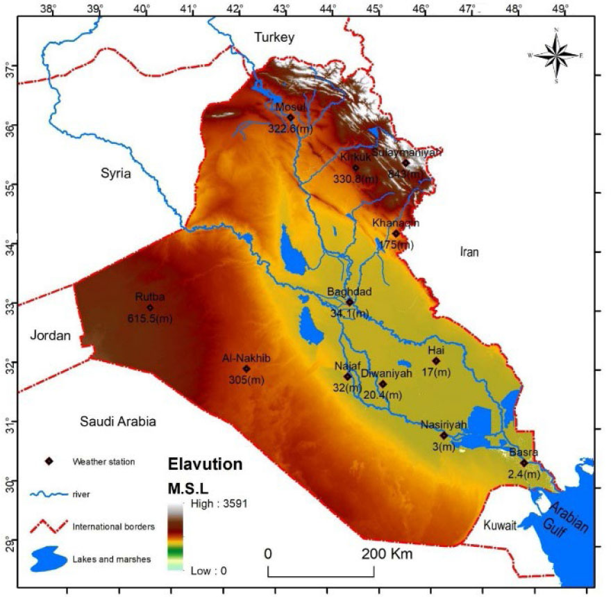
Figure 1.
Hypsometric map of Iraq with spatial distribution of meteorological stations used in the paper
Source: Republic of Iraq, Ministry of Water Resources, General Authority for Survey, Survey Department, 2021, and digital elevation model
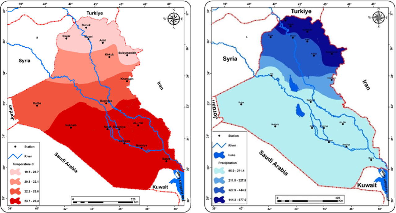
Figure 2.
Average annual air temperatures in Iraq from 1978 to 2020 (a): Mean annual precipitation in Iraq from 1978–2020 (b)
Source: adapted from Muslih & Abbas (2024)
Table 2.
The amount of annual change in maximum, minimum and average temperatures at a significance level of 99%, and the seasonal change in rainfall after a significance level of 95% with a bold line and the one below it with a line at a level of 90%)
| Station | Tmax | Tmin | Tmean | Rainfall |
|---|---|---|---|---|
| Mosul | 0.035 | 0.055 | 0.033 | −1.015 |
| Sulaimaniya | 0.046 | 0.042 | 0.028 | −1.909 |
| Kirkuk | 0.058 | 0.093 | 0.071 | −2.804 |
| Khanaqin | 0.082 | 0.084 | 0.081 | −2.245 |
| Rutba | 0.053 | 0.080 | 0.087 | −0.680 |
| Baghdad | 0.057 | 0.091 | 0.073 | −0.464 |
| Hai | 0.063 | 0.085 | 0.067 | −0.910 |
| Diwaniya | 0.058 | 0.103 | 0.067 | −0.509 |
| Nasiriya | 0.083 | 0.103 | 0.067 | −0.834 |
| Basrah | 0.137 | 0.106 | 0.120 | −1.360 |
Table 3:
Recurrence of the opposite pattern resulting from the combination of increased temperature with decreased total rainfall and vice versa in Iraqi stations for 1974–2021
| Station | Increased temperature with decreased rainfall | Decreased temperature with increased rainfall | ||||
|---|---|---|---|---|---|---|
| Tmax | Tmin | Tmean | Tmax | Tmin | Tmean | |
| Mosul | 15 | 16 | 16 | 10 | 15 | 13 |
| Sulaimaniya | 15 | 13 | 14 | 15 | 13 | 12 |
| Kirkuk | 15 | 12 | 15 | 16 | 13 | 15 |
| Khanaqin | 16 | 15 | 15 | 16 | 14 | 15 |
| Rutba | 17 | 17 | 12 | 12 | 14 | 14 |
| Baghdad | 14 | 15 | 16 | 13 | 12 | 14 |
| Hai | 16 | 16 | 16 | 13 | 12 | 12 |
| Diwaniya | 12 | 13 | 13 | 15 | 9 | 12 |
| Nasiriya | 13 | 14 | 14 | 12 | 15 | 15 |
| Basrah | 15 | 14 | 15 | 11 | 16 | 12 |
| Sum. | 148 | 145 | 146 | 133 | 133 | 134 |
| Perc. | 33.7 | 33.0 | 33.3 | 33.25 | 33.25 | 33.5 |
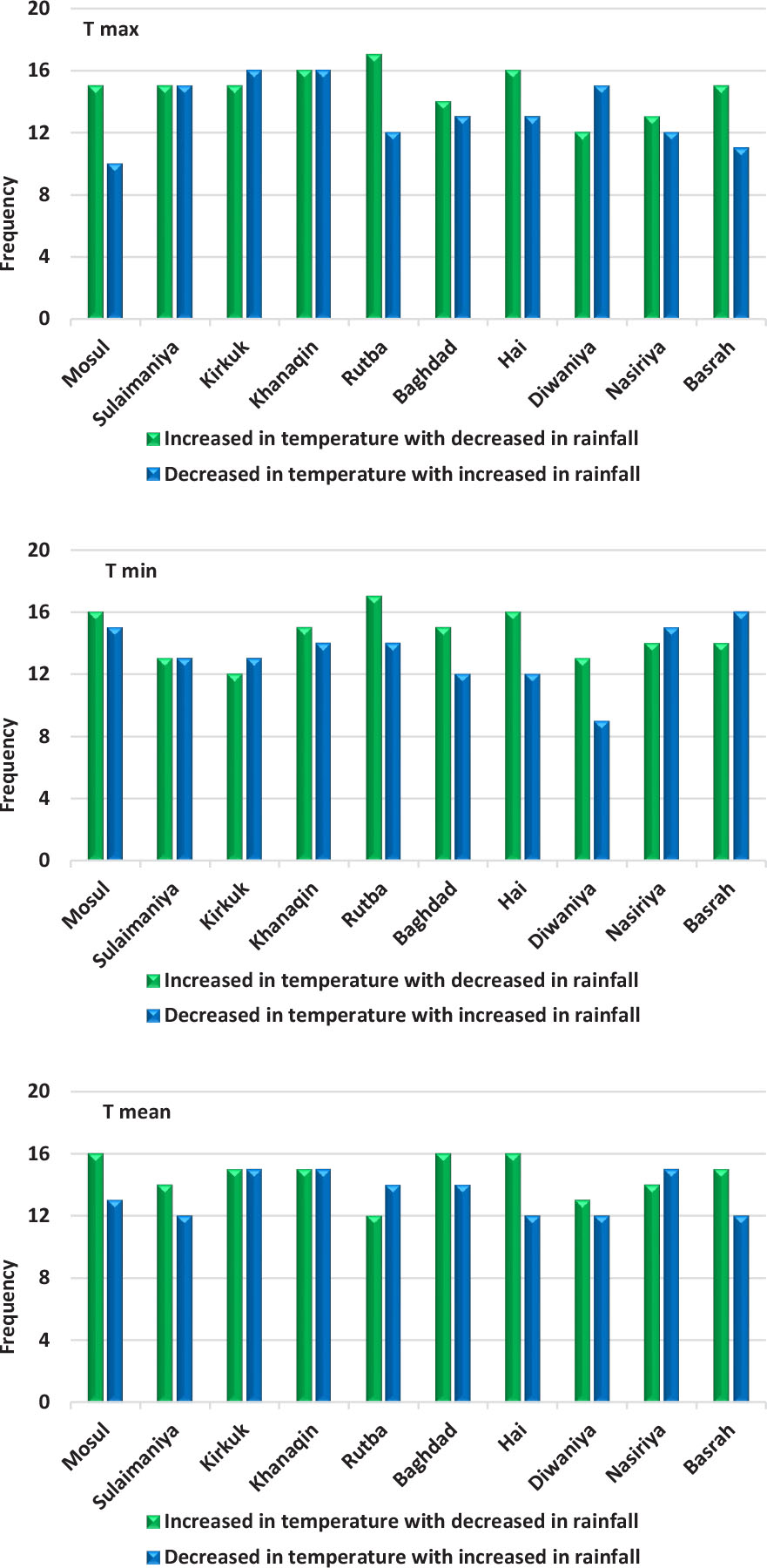
Figure 3.
Repetition of the opposite pattern resulting from the combination of increased temperature (maximum, minimum and average) with a decrease in total seasonal rainfall and vice versa in Iraq stations for 1974–2021
Source: Based on data from Table 3
Table 4.
Repetition of similar patterns resulting from the combination of the increase in temperature with the increase in total rainfall and vice versa in the stations of Iraq for 1974–2021
| Station | Increase in temperature with increase in total rainfall | Decrease in temperature with decrease in total rainfall | ||||
|---|---|---|---|---|---|---|
| Tmax | Tmin | Tmean | Tmax | Tmin | Tmean | |
| Mosul | 11 | 6 | 8 | 12 | 11 | 11 |
| Sulaimaniya | 10 | 12 | 13 | 8 | 11 | 10 |
| Kirkuk | 5 | 8 | 6 | 12 | 15 | 12 |
| Khanaqin | 6 | 8 | 7 | 10 | 11 | 11 |
| Rutba | 6 | 4 | 4 | 13 | 13 | 18 |
| Baghdad | 7 | 8 | 6 | 14 | 13 | 12 |
| Hai | 7 | 8 | 8 | 12 | 12 | 12 |
| Diwaniya | 9 | 14 | 11 | 12 | 12 | 13 |
| Nasiriya | 10 | 7 | 10 | 13 | 12 | 12 |
| Basrah | 12 | 7 | 11 | 10 | 11 | 10 |
| Sum. | 83 | 82 | 84 | 116 | 121 | 121 |
| Perc. | 33.4 | 32.9 | 33.7 | 32.4 | 33.8 | 33.8 |
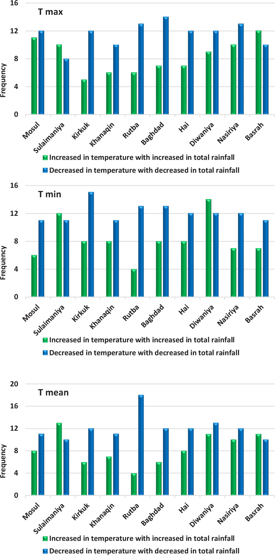
Figure 4.
Repetition of a similar pattern resulting from the coupling of the temperature increase (maximum, minimum and average) with the rise in the total seasonal rainfall and vice versa at the stations of Iraq for 1974–2021
Source: Based on data from Table 4
Table 5.
Simple correlation between annual summer temperature rates and total seasonal rainfall for 1974–2021
Table 6.
Simple correlation between monthly summer temperature rates and total seasonal rainfall for 1974–2021
| Station | Maximum temperature | Minimum temperature | Mean temperature | ||||||
|---|---|---|---|---|---|---|---|---|---|
| Jun | July | August | Jun | July | August | Jun | July | August | |
| Mosul | −0.053 | −0.163 | 0.063 | −0.363* | −0.365* | −0.272* | −0.342* | −0.047 | −0.121 |
| Sulaimaniya | −0.194 | −0.174 | −0.160 | −0.215 | −0.099 | 0.147 | −0.200 | −0.169 | 0.055 |
| Kirkuk | −0.146 | −0.165 | −0.101 | −0.337* | −0.331* | −0.165 | −0.223 | −0.201 | −0.090 |
| Khanaqin | −0.039 | −0.058 | −0.040 | −0.205 | −0.177 | −0.145 | −0.145 | −0.145 | −0.089 |
| Rutba | −0.159 | 0.058 | −0.138 | 0.139 | 0.061 | 0.073 | −0.103 | 0.050 | −0.026 |
| Baghdad | −0.223 | −0.184 | −0.155 | −0.011 | −0.019 | −0.095 | −0.256* | −0.195 | −0.130 |
| Hai | −0.158 | −0.105 | 0.029 | −0.107 | −0.084 | 0.008 | −0.124 | −0.126 | 0.006 |
| Diwaniya | −0.194 | 0.084 | 0.192 | 0.104 | 0.012 | 0.126 | −0.140 | −0.093 | 0.039 |
| Nasiriya | −0.258* | −0.254* | 0.124 | −0.075 | −0.097 | −0.036 | −0.292* | −0.272* | −0.187 |
| Basrah | −0.318* | −0.188 | −0.223 | −0.162 | −0.122 | −0.055 | −0.263* | −0.213 | −0.220 |
Table 7.
Characteristics of the years selected for interpretation during the summer and the following season in Iraq
| Year | Tmax | Tmin | Tmean | Rainfall | Year class | ||||
|---|---|---|---|---|---|---|---|---|---|
| Average annal temperature | General average | Average annual temperature | General average | Average annual temperature | General average | Annual rainfall rate | General average rainfall | ||
| 1993 | 42.1 | 42.6 | 25.6 | 26.2 | 34.1 | 34.6 | 379.6 | 242.7 | Wet |
| 2010 | 44.0 | 28.0 | 36.0 | 224.8 | Dry | ||||
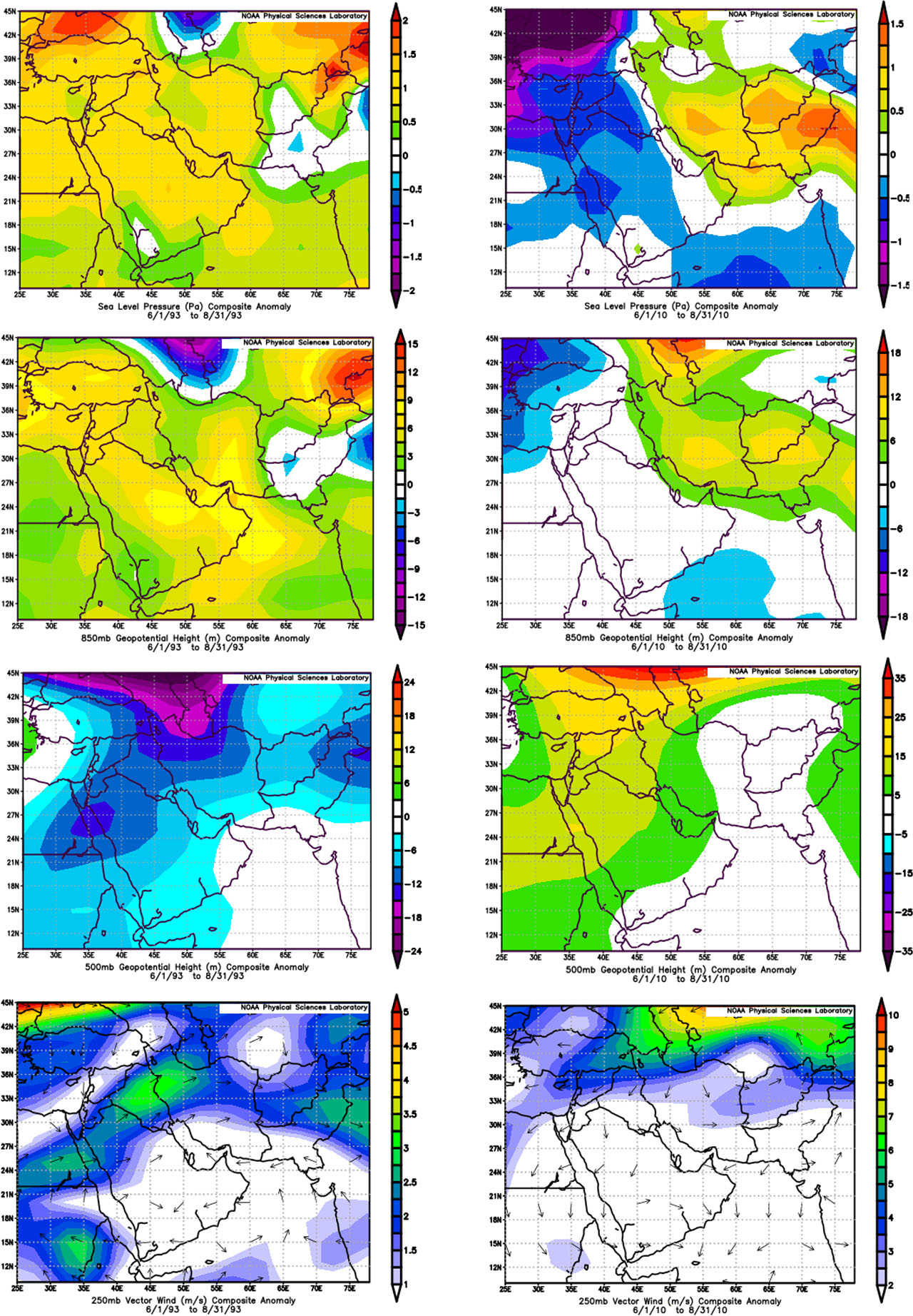
Figure 5.
Summer synoptic coupling patterns in Iraq for 1993 and 2010, (from left to right respectively). Pressure anomaly at sea level (hPa) (top panels); pressure height anomaly at 850 hPa (top second row panels); pressure height anomaly at 500 hPa (Third row panels from top); and wind speed anomaly (m/s) at 250 hPa (bottom panels).
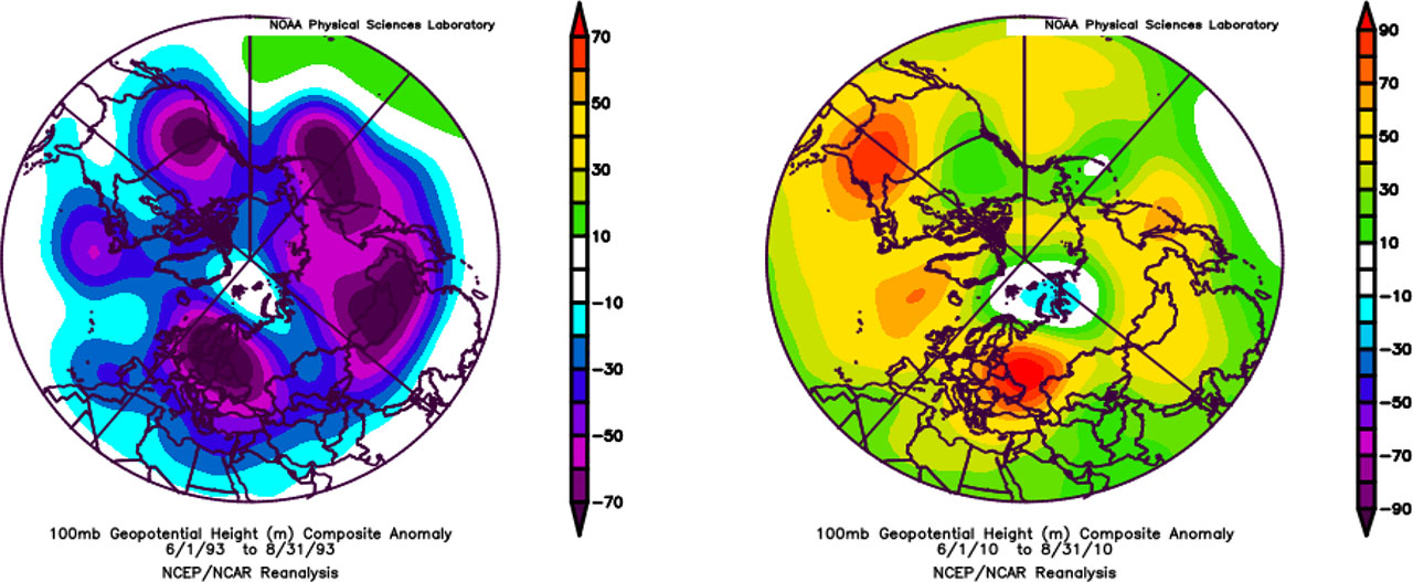
Figure 6.
Anomaly of the pressure rise of the 100 hPa level from the left for the summer of 1993 and from the right for the summer of 2010
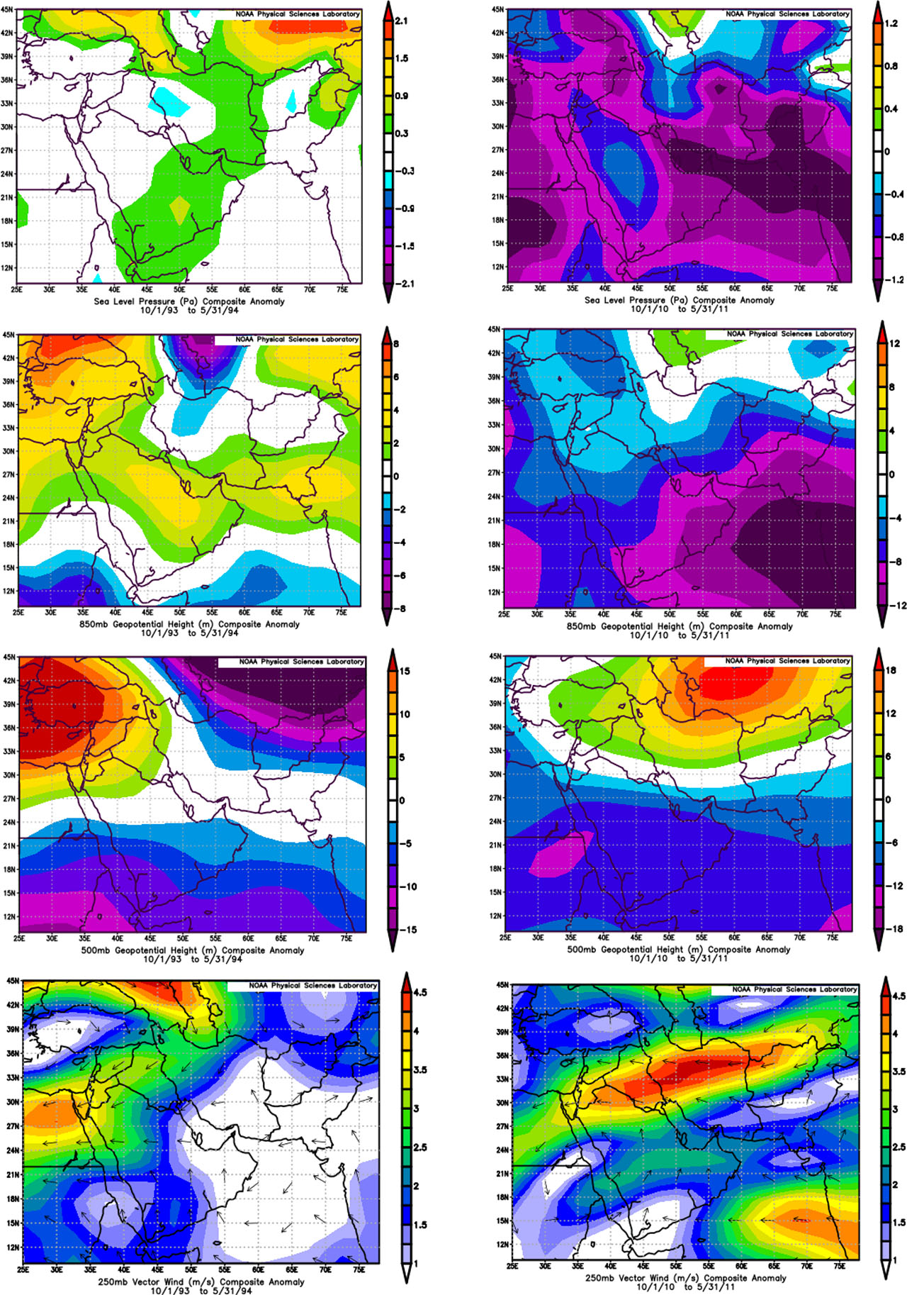
Figure 7.
synoptic coupling patterns for the rainy season in Iraq (1993/1994 and 2010/2011), from left to right respectively. Pressure anomaly at sea level (hPa) (top panels); pressure anomaly at 850 hPa (top second row panels); pressure anomaly at 500 hPa (top third row panels); and wind speed anomaly (m/s) at 250 hPa (bottom panels)
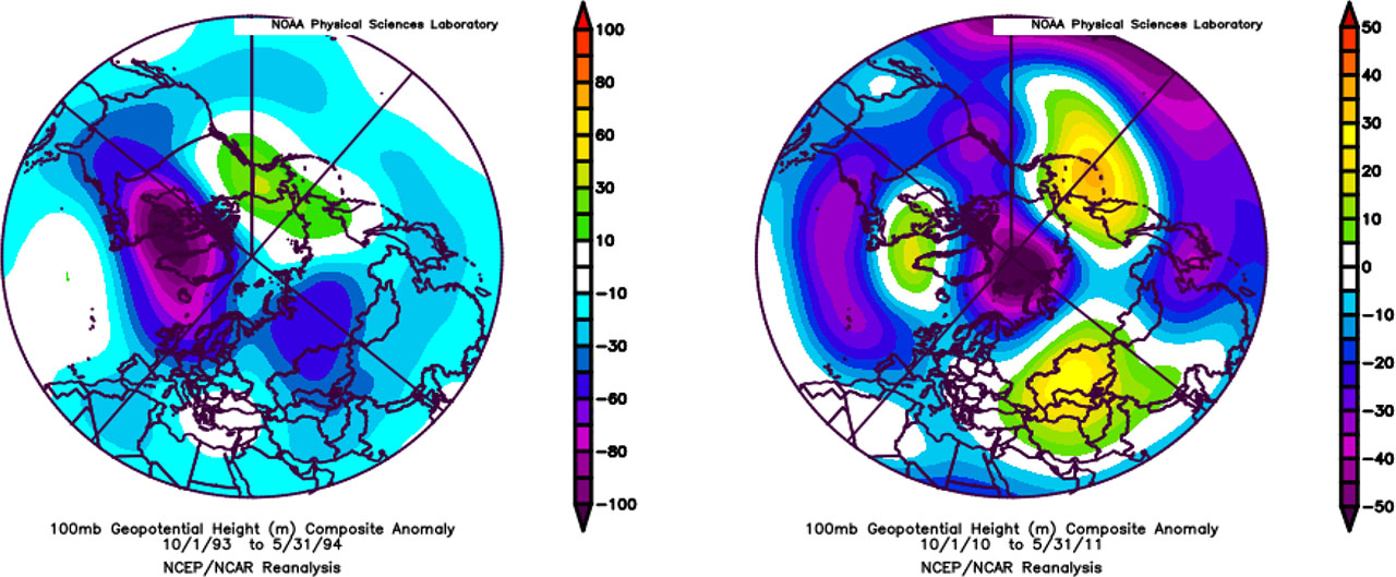
Figure 8.
Anomaly of the (100) (hPa) level from the left for the rainy season (1993/1994) and from the right for the rainy season (2010/2011)