
Introduction
National Forest Inventories (NFIs) are a fundamental tool for obtaining strategically important information on the state and dynamics of forest resources and ecosystems and is essential for sustainable forest management and the preparation of national and international reports (Vidal et al. 2016). In modern European forest monitoring practice, increasing attention is paid to edaphic characteristics, as soil properties largely determine the productivity of forest stands and are one of the key reservoirs of organic carbon in forest ecosystems (Wellbrock et al. 2016; Manual on methods and criteria … 2020). The new EU Directive on soil monitoring and resilience (EU) 2025/2360 establishes harmonized requirements for soil status indicators at the national level. This creates additional impetus for integrating forest soil data into the European monitoring system and supports a more comprehensive approach to land resource management (Directive (EU) 2025/2360, 2025).
In most countries, forest inventories include comprehensive assessments of the main components of the forest ecosystem, including soils, which significantly affect the productivity, sustainability, and response of forest stands to environmental stress. Internationally, soil research is integrated into the general monitoring network and aims to assess the overall fertility of soils, their physical and chemical condition, and ecological stability using morphological and laboratory and analytical methods. Unlike many European countries with longterm forest soil monitoring observations, Ukraine has lacked a systematic national forest soil monitoring programme, which limits the availability of consistent reference data on forest soil status and trends. In this context, the newly established National Forest Inventory of Ukraine plays a key role in generating harmonised information on forest soils and site conditions, as its design includes edaphic measurements collected together with stand and ground vegetation characteristics on a network of permanent sample plots (Procedure for conducting… 2021).
The Ukrainian NFI was launched in 2021 based on permanent sample plots. The first cycle was implemented under significant constraints related to limited access to certain areas and uneven coverage of the sample plot network. In such conditions, the reliability of primary field measurements becomes particularly important, as errors at the level of individual plots directly affect national estimates (FAO 2017).
Analysis of a sample of NFI data from the first measurement cycle (2021–2023) revealed a number of methodological aspects of the edaphic module that need to be clarified and further improved. The current classification of forest site conditions based on the Alexeev–Pogrebnyak vegetation-based system (phytoindication) is an effective tool. However, under anthropogenic pressure, it should be complemented with measurable soil indicators (Procedure for conducting… 2021; Wellbrock et al. 2016). In particular, limited soil pit depth and the lack of mandatory laboratory measurements of soil properties related to organic carbon stocks and physical characteristics may reduce the accuracy of site productivity and ecological assessment (Raspopina 2023; Wellbrock et al. 2016).
Previous studies demonstrated significant relationships between soil profile morphology and forest stand productivity (Raspopina 2017; 2023). These findings suggest that indicators such as humus horizon thickness and soil texture can be used as objective parameters for cross-validating site classification within NFI systems (Tomppo et al. 2010).
However, integrating these indicators into a comprehensive NFI data quality assurance system in Ukraine requires further methodological development and formalization.
International experience shows that robust QA/QC procedures are essential for national forest inventories, as data inconsistencies can bias estimates of forest resources and hinder the assessment of forest degradation (Brandeis et al. 2017; FAO 2021).
This study proposes a structured framework for evaluating the internal consistency of edaphic records in the Ukrainian NFI by combining rule-based ecological validation with independent expert assessment of soil profile photographs. The proposed approach strengthens QA/QC procedures and supports harmonisation with European forest monitoring practice.
The aim of this study is to develop and justify methodological approaches for improving the edaphic module of the Ukrainian NFI through cross-validation procedures and a multi-level data quality control framework.
Material and methods
Study design and data source
This study was based on data from the Ukrainian National Forest Inventory (NFI), which applies a systematic sampling design using permanent circular sample plots arranged on a 5 × 5 km grid (Procedure for conducting… 2021). Each sample plot consists of concentric circular subplots used for measuring trees of different diameter classes.
Field data collection and database management are carried out by the National Forest Inventory Centre of the Ukrainian State Forest Inventory Enterprise Ukrderzhlisproekt, while scientific and methodological support for the Ukrainian NFI is provided by the Ukrainian Research Institute of Forestry and Forest Melioration (URIFFM).
The analysis was based on an available subset of the Ukrainian NFI database comprising records from 878 permanent sample plots surveyed during the 2021–2023 field campaigns. The study relied exclusively on data collected within the NFI programme, including field descriptions and soil profile photographs stored in the database. No additional field surveys or independent field measurements were conducted by the authors.
The analysed dataset included soil profile photographs for 120 sample plots located in the Polissia and Forest-Steppe zones (Kyiv, Zhytomyr, Vinnytsia and Khmelnytskyi regions). These photographs, together with the corresponding field descriptions stored in the NFI database, were independently evaluated by an experienced forest soil scientist.
Edaphic module and typological indicators
According to the Ukrainian NFI field protocol (Procedure for conducting… 2021), edaphic observations are collected from a soil pit excavated to a depth of approximately 30 cm, with extension to about 50 cm where required by local soil conditions.
Forest site conditions in the Ukrainian NFI are classified according to the Alexeev–Pogrebnyak forest typology, one of the traditional ecological forest classification systems used in Ukraine for forest management. Each forest site type represents a relatively homogeneous combination of site fertility (trophic) conditions, soil moisture and characteristic vegetation. Forest site conditions are expressed by combining trophic classes (A–D, from poor to rich sites) with moisture classes (0–5, from very dry to wet), providing an integrated ecological description of the growing conditions (Bondar et al. 2020; Pogrebnyak 1955; Ostapenko and Tkach 2002).
In this study, the term site fertility refers to the trophic status of forest habitats determined by soil properties within the Alexeev–Pogrebnyak typological system and should not be interpreted as stand productivity or site index.
The NFI edaphic module records (Procedure for conducting… 2021):
– morphological description of the soil profile and thickness of genetic horizons;
– soil type according to the Ukrainian soil classification;
– soil texture estimated in the field using the Kachin-sky hand-texturing method;
– forest floor humus form (Mor, Moder, Mull and transitional forms);
– forest site conditions according to the Alexeev–Pogrebnyak forest typology, including trophic classes (A–D) and moisture classes (0–5).
For each soil pit, a photograph of the exposed soil profile is stored together with the field description in the NFI database to facilitate subsequent verification of horizon boundaries and humus forms.
The current NFI protocol does not include laboratory measurements of soil physical or chemical properties. Consequently, soil texture represents a field estimate rather than a laboratory-verified characteristic. Likewise, humus forms are recorded using a simplified classification that is not fully harmonised with European systems such as those of Zanella et al. (2011) and Jabiol et al. (2004).
Rule-based consistency assessment
The internal consistency of the recorded edaphic information was evaluated using a three-level validation framework comprising:
rule-based consistency assessment of ecological relationships among forest site conditions, soil characteristics and dominant tree species;
independent expert review of soil profile photographs and field descriptions;
comparison with published regional reference information.
The first stage consisted of a rule-based consistency assessment based on the expected ecological relationships between forest site conditions, soil type, soil texture, humus form and dominant tree species summarised in Table 1. These relationships were derived from published Ukrainian forest typology, soil classification and forest soil studies (Pogrebnyak 1955; Ostapenko and Tkach 2002; Polupan et al. 2005; Raspopina 2017; 2023; Zanella et al. 2011).
Table 1.
Expected relationships between forest site condition, soil properties and humus forms used for rule-based ecological validation of NFI data
| Forest site type | Typical soils | Typical soil texture | Typical humus form | Typical tree species |
|---|---|---|---|---|
| A (poor sites) | Sod-podzolic soils | Sand | Moder (Mor) | Scots pine, birch |
| B (relatively poor sites) | Sod-podzolic soils | Sandy loams – light loams | Moder | Scots pine, oak |
| C (moderately fertile sites) | Grey forest soils | Sandy loams – light loams | Mull (Moder-Mull transitional forms) | Oak, hornbeam, maple, lime |
| D (fertile sites) | Dark grey forest soils, Chernozems, Brown forest soils | Medium to heavy loams and clays | Mull | Oak, ash, hornbeam, maple |
[i] Source: Compiled by the authors based on the Ukrainian forest typology (Pogrebnyak 1955, Ostapenko & Tkach 2002), forest soil fertility studies (Raspopina 2017, 2023) and forest floor classification (Zanella et al. 2011).
Records that complied with the expected combinations presented in Table 1 were classified as ecologically consistent, whereas records containing ecologically implausible combinations were classified as potentially inconsistent. Such records were treated as potential data quality issues requiring further verification rather than automatically regarded as field errors.
The second stage consisted of an independent review of the available soil profile photographs (n = 120) together with the corresponding field descriptions stored in the NFI database. The expert assessed the plausibility of the recorded forest site conditions, soil type, soil texture and humus form based on the available documentation.
The third stage compared the recorded soil and forest site descriptions with published regional soil maps and reference information on zonal soil distribution (Polupan et al. 2005; Bondar et al. 2016; Lakyda et al. 2019; Tkach et al. 2024) to evaluate their ecological plausibility.
Data analysis
Data completeness was assessed as the proportion of available records relative to the expected number of observations for each edaphic variable.
For each ecological consistency rule (Tab. 1), records were classified using a binary indicator, where 1 represented an ecologically consistent record and 0 represented a potentially inconsistent record. The number and proportion of consistent records were calculated for the analysed subset of 878 NFI plots. For the subset of 120 plots with available soil profile photographs, the agreement between the original field records and the independent expert assessment was evaluated using the same criteria.
The objective of the analysis was to assess the internal consistency of categorical edaphic records and identify systematic patterns that may indicate methodological weaknesses in the current NFI soil module. Because all evaluated variables were categorical and the purpose of the study was consistency assessment rather than hypothesis testing, no inferential statistical analyses were performed. Results are therefore presented as frequencies and proportions of ecologically consistent records.
Results
Analysis of forest site classification
Analysis of edaphic records from a subset of the Ukrainian NFI database (878 sample plots surveyed during 2021–2023) revealed inconsistencies between forest site classification and several recorded edaphic indicators. These findings suggest that reliance solely on vegetation-based site classification may overlook ecologically implausible combinations. The assessment was based exclusively on the information recorded in the NFI database; no additional field verification was performed.
A rule-based consistency check based on the ecological relationships defined in Table 1 was applied to these records (Tab. 2).
Table 2.
Results of the rule-based consistency check of edaphic records on subset of NFI plots (n=878)
| Indicator (logical check) | Number of plots with consistent records | Share of plots with consistent records (%) |
|---|---|---|
| Tree Species composition vs Forest site condition | 774 | 88.2 |
| Forest site condition vs Soil type | 671 | 76.4 |
| Forest site condition vs Soil texture* | 624 | 71.1 |
The analysed NFI records were consistent in 88% of cases for the relationship between dominant tree species and forest site condition, in 76% for forest site condition and soil type, and in 71% for forest site condition and soil texture. In contrast, only about 18% of plots had humus form codes that were consistent with the dominant tree species and site conditions according to the applied criteria (Moder in conifer-dominated A–C sites, Mull in broadleaved C–D sites), while the widespread use of Mor and Amphi codes suggests inconsistencies in the field identification of humus forms in the current NFI practice.
These proportions represent the frequency of logically consistent records within the analyzed NFI database subset and should be interpreted as indicators of internal data consistency rather than estimates of field accuracy.
For the expert-reviewed subset (n = 120), agreement between the original NFI field records and the expert assessment was 71% for forest site condition, 73% for soil type, 69% for soil texture and only 19% for humus forms (Tab. 3). The lowest agreement observed for humus forms indicates substantial inconsistencies in their field identification compared with the other edaphic indicators.
Table 3.
Agreement between original NFI field records and independent expert assessment for the subset of plots with available soil profile photographs (n = 120)
| Indicator | Number of plots with consistent records (n) | Share of plots with consistent records (%) |
|---|---|---|
| Forest site condition | 85 | 70.8 |
| Soil type | 88 | 73.1 |
| Humus form | 23 | 19.1 |
| Soil texture* | 83 | 68.9 |
The independent expert review also identified inconsistencies between the recorded soil types and field-estimated soil texture. In particular, a substantial proportion of Grey Forest Soils and Chernozems were recorded as having sandy texture, despite their known genetic characteristics and the expected ecological relationships summarised in Table 1. These records represent another typical example of inconsistencies identified during the validation process.
The expert review showed that Mor was the predominant humus form recorded in the original NFI database (74.9% of plots), including many productive broadleaved stands and fertile forest site conditions where Mull or Moder–Mull transitional forms would be expected. This illustrates one of the most common inconsistencies identified during the validation.
Soil pit depth as a factor affecting classification accuracy
Analysis of the NFI field records and soil profile photographs showed that the standard excavation depth of approximately 30 cm was frequently insufficient to expose the complete humus horizon in fertile forest soils. This limitation was particularly evident in Grey Forest Soils and Chernozems of the Forest-Steppe, where the humus profile often extended below the standard pit depth (Fig. 1).
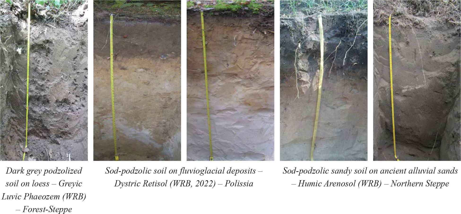
Figure 1.
Examples of soil profile morphology illustrating differences in humus horizon thickness among major ecological zones of Ukraine (photos by the authors)
Previous studies conducted in Ukrainian forests demonstrated a statistically significant correlation (r = 0.66) between humus horizon thickness and forest stand productivity (Raspopina, 2017; 2023). These studies also established regional reference values for humus horizon depth corresponding to different forest site fertility classes.
Based on these previously published results, practical reference thresholds for humus horizon depth are presented in Table 4. These thresholds provide an ecological reference for evaluating site fertility during NFI quality assessment.
Table 4.
Reference humus horizon depth thresholds for forest site fertility classes in Ukraine (adapted from Raspopina, 2017; 2023)
| Site fertility class | The humus horizon depth (thickness), cm | |
|---|---|---|
| Polissia Forest-Steppe, Northern Steppe | ||
| A | <10 (15) | <15 |
| AB | 10 | 15 |
| B | 15 | 15 |
| BC | 20 | 35 |
| C, D | 25 | 40 |
Accordingly, if a site recorded as fertile (D) is associated with sandy texture or a humus horizon thinner than 15 cm, the record should be considered ecologically atypical and subjected to additional verification.
A case study based on photographic records of soil profiles confirmed the effectiveness of morphological verification. In this case, the field classification of “sandy sod-podzolic soil” did not correspond to stand composition, site index, or soil profile morphology. Photographic documentation made it possible to identify this discrepancy and refine the soil description.
Together, the rule-based validation and expert review identified several ecologically inconsistent records and highlighted opportunities for further methodological refinement of the Ukrainian NFI edaphic module.
Discussion
The present study identified systematic inconsistencies within the edaphic component of the Ukrainian National Forest Inventory (NFI). Both the rule-based validation and the independent expert assessment revealed ecologically implausible combinations of forest site conditions, soil type, soil texture and humus forms. These inconsistencies should not be interpreted as evidence of widespread field errors but rather as indications of methodological limitations, observer variability and the absence of dedicated ecological QA/QC procedures for edaphic indicators. Similar challenges have been reported during the development of other national forest inventories (FAO 2017; Vidal et al. 2016; O’Neill et al. 2005).
Experience from forest soil disturbance monitoring in North America demonstrates that insufficiently detailed field guidance and ambiguous classification criteria may substantially reduce consistency among field crews. Early versions of the Forest Soil Disturbance Monitoring Protocol showed considerable observer variability, which led to refinement of disturbance classes, development of photographic reference guides and implementation of structured quality assurance procedures, including repeat assessments and observer agreement checks (Page-Dumroese et al. 2010; Yanai et al. 2023; Brandeis et al. 2017). Likewise, the predominance of Mor and Amphi humus forms in productive broadleaved stands, together with inconsistencies between recorded soil type and field-estimated soil texture identified in the present study, suggests that humus form identification and field interpretation represent the least robust components of the current Ukrainian NFI edaphic module.
European forest monitoring programmes provide useful examples of more comprehensive soil QA/QC systems. ICP Forests applies harmonised protocols for soil profile description, sampling depths, analytical procedures and quality assurance, while interlaboratory comparisons ensure consistency of soil and deposition measurements (Manual on Methods and Criteria… 2020). Similarly, the German National Forest Soil Inventory emphasises continuous refinement of field protocols, indicator selection and QA procedures to improve long-term assessment of soil acidification, nutrient status and ecosystem functioning (Wellbrock et al. 2016). Compared with these systems, the Ukrainian NFI currently lacks laboratory verification of key soil properties and a dedicated QA/QC framework specifically designed for edaphic observations.
One methodological issue highlighted by the present study concerns the standard depth of soil pits used in the Ukrainian NFI. The current protocol generally limits excavation to approximately 30 cm, whereas observations from the analysed soil profile photographs indicate that this depth is frequently insufficient to expose the complete humus horizon in fertile Forest-Steppe soils. Previous studies conducted in Ukrainian forests demonstrated a statistically significant relationship between humus horizon thickness and stand productivity (r = 0.66) and established regional reference values for humus horizon depth across forest site fertility classes (Raspopina 2017; 2023). Although these threshold values were not derived from the present dataset, they provide an ecological basis for interpreting the inconsistencies identified in the analysed NFI records and for defining practical reference criteria for quality assessment.
The results further demonstrate the value of combining field-estimated soil texture with humus horizon thickness as complementary indicators for cross-validation of forest site fertility. Although field texture estimates obtained using the Kachinsky method are indicative rather than laboratory-based measurements, their joint interpretation with humus characteristics provides a simple, inexpensive and operationally feasible quality assurance tool for identifying ecologically implausible site classifications. For example, fertile forest site conditions (D) associated with sandy texture or with a shallow humus horizon should be considered atypical and subjected to additional verification rather than accepted without review. This recommendation is consistent with international forest soil monitoring practice, where soil profile depth and field description are adapted to local edaphic conditions rather than being restricted to a fixed excavation depth (Manual on Methods and Criteria. 2020).
The proposed rule-based validation framework operationalises expected ecological relationships among forest site conditions, soil type, soil texture, humus forms and dominant tree species. Application of these rules successfully identified typical inconsistencies, including Grey Forest Soils and Chernozems recorded as having sandy texture and Mor humus forms assigned to productive broadleaved stands. Furthermore, comparison between original NFI field records and independent expert assessment demonstrated that humus form classification showed the lowest agreement among all evaluated edaphic indicators. These findings indicate that simple categorical agreement measures combined with ecological consistency rules can provide practical QA/QC metrics for routine evaluation of NFI field data (Brandeis et al. 2017; FAO, 2021).
The current Ukrainian NFI already incorporates standard quality control procedures, including completeness checks, logical validation and office-based verification during data entry (FAO 2017; Procedure for conducting… 2021). However, these procedures primarily assess data completeness and internal logical consistency. The framework proposed in this study complements the existing system by introducing ecological cross-validation based on independent soil indicators and expert verification of selected records. Such an approach allows systematic identification of plots, forest site types and regions where additional training, protocol refinement or repeated field assessment may be required.
International experience also demonstrates that field morphology and texture alone cannot provide comprehensive assessment of soil fertility, acidification, carbon stocks and nutrient status. Reliable evaluation of these properties requires laboratory analyses of soil organic carbon, pH, bulk density, granulometric composition and related indicators (Wellbrock et al. 2016; Manual on Methods and Criteria… 2020; FAO 2017). Although laboratory analysis of every NFI plot is unlikely to be operationally feasible, a stratified approach combining laboratory measurements on a representative subset of plots with improved field protocols, flexible soil pit depths adapted to local soil conditions and the rule-based ecological cross-validation proposed in this study could substantially strengthen the ecological robustness, data quality and international comparability of the Ukrainian NFI.
These findings also have practical implications for the further development of the Ukrainian NFI field protocol. First, greater flexibility in soil pit depth could improve characterization of humus horizons in fertile forest soils, particularly in Grey Forest Soils and Chernozems of the Forest-Steppe, where the humus horizon may extend below the current standard excavation depth. Second, greater consistency of humus form assessment could be achieved through a simplified operational classification focused on the principal forms (Mull, Moder and Mor) and, where appropriate, harmonised with European classification systems. Third, future development of the Ukrainian NFI could consider introducing a limited core set of laboratory soil parameters, particularly soil organic carbon and bulk density, on a representative subset of plots to support interpretation of field observations and strengthen the ecological reliability of forest site classification.
Finally, the inconsistencies identified in this study should be regarded not as deficiencies of the Ukrainian NFI itself but as opportunities for further methodological development. The proposed validation framework is intended to complement the existing inventory methodology by providing an additional layer of ecological quality assurance that can improve the consistency, transparency and reliability of edaphic observations while maintaining compatibility with international forest monitoring approaches.
Conclusions
Analysis of the Ukrainian NFI edaphic records demonstrated that soil-based indicators provide an independent and effective means of evaluating the internal consistency of forest site classification. Rule-based validation and independent expert assessment revealed generally high consistency for forest site conditions, soil type and soil texture, while indicating substantially greater variability in humus form classification and showing that the current standard soil pit depth of approximately 30 cm may not always be sufficient to fully characterise humus horizons in fertile Forest-Steppe soils.
The combined use of field-estimated soil texture and humus horizon thickness provides a practical, low-cost tool for cross-validating forest site classification, identifying ecologically atypical combinations requiring additional verification and supporting a simplified operational classification of humus forms based on the principal Mull, Moder and Mor types.
The proposed ecological QA/QC framework, integrating rule-based validation, selective expert verification, flexible soil pit depths and targeted laboratory analyses of core soil parameters on a representative subset of plots, offers a practical approach for strengthening the consistency, transparency and international comparability of the Ukrainian NFI edaphic module while complementing the existing quality assurance procedures.