
Table 1.
General description of the international beech provenance tests of the 1993/95 series (adapted from information provided by the Institute for Forest Genetics and Forest Tree Breeding, Großhansdorf, Germany). ID – trial designation according to Figure 1, VersNr – official designation of the provenance trial, Ort – official name of the provenance test trial, LAT – latitude (degrees and minutes), LON – longitude (degrees and minutes), ALT – altitude (meters above sea level).
| ID | VersNr | Ort | Country | LAT | LON | ALT |
|---|---|---|---|---|---|---|
| 01 | Bu19_01 | Schädtbek | Germany | 54° 18′ N | 10° 18′ E | 40 |
| 02 | Bu19_02 | Wesel | Germany | 51° 39′ N | 6° 23′ E | 40 |
| 03 | Bu19_03 | Malter | Germany | 50° 56′ N | 13° 40′ E | 360 |
| 04 | Bu19_04 | Navarra | Spain | 43° 0′ N | 1° 20′ W | 910 |
| 05 | Bu19_05 | Vrchdobroc | Slovakia | 48° 36′ N | 19° 38′ E | 840 |
| 06 | Bu19_06 | Bilogora | Croatia | 45° 55′ N | 16° 58′ E | 220 |
| 07 | Bu19_07 | Gablitz | Austria | 48° 15′ N | 16° 7′ E | 350 |
| 80 | Bu19_08 | Otterup | Denmark | 55° 31′ N | 10° 25′ E | 5 |
| 09 | Bu19_09 | FD de Lyons | France | 49° 29′ N | 1° 36′ E | 190 |
| 10 | Bu19_10 | Bologna | Italy | 44° 6′ N | 11° 6′ E | 930 |
| 11 | Bu19_11 | Rathdnum | Ireland | 52° 30′ N | 6° 10′ W | 106 |
| 12 | Bu19_12 | Chilterns FD | United Kingdom | 51° 37′ N | 0° 57′ E | 180 |
| 13 | Bu19_13 | Loehlitz | Germany | 49° 53′ N | 11° 24′ E | 430 |
| 14 | Bu19_14 | Benesov | Czech Republic | 49° 21′ N | 15° 1′ E | 630 |
| 15 | Bu19_15 | Oleszyce | Poland | 50° 10′ N | 22° 55′ E | 200 |
| 16 | Bu19_16 | Nedlitz | Germany | 51° 59′ N | 12° 19′ E | 120 |
| 17 | Bu19_17 | Brasov | Romania | 45° 33′ N | 25° 45′ E | 800 |
| 18 | Bu19_18 | Livadkite | Bulgaria | 42° 40′ N | 26° 50′ E | 1150 |
| 19 | Bu19_19 | Roztochja | Ukraine | 49° 55′ N | 23° 42′ E | 330 |
| 20 | Bu19_20 | Laski | Poland | 51° 11′ N | 18° 2′ E | 234 |
| 21 | Bu19_21 | Ranna | Sweden | 58° 27′ N | 13° 50′ E | 160 |
| 22 | Bu19_22 | Louschelt | Luxembourg | 49° 53′ N | 5° 47′ E | 425 |
| 23 | Bu19_23 | Baia Mare | Romania | 47° 35′ N | 24° 4′ E | 640 |
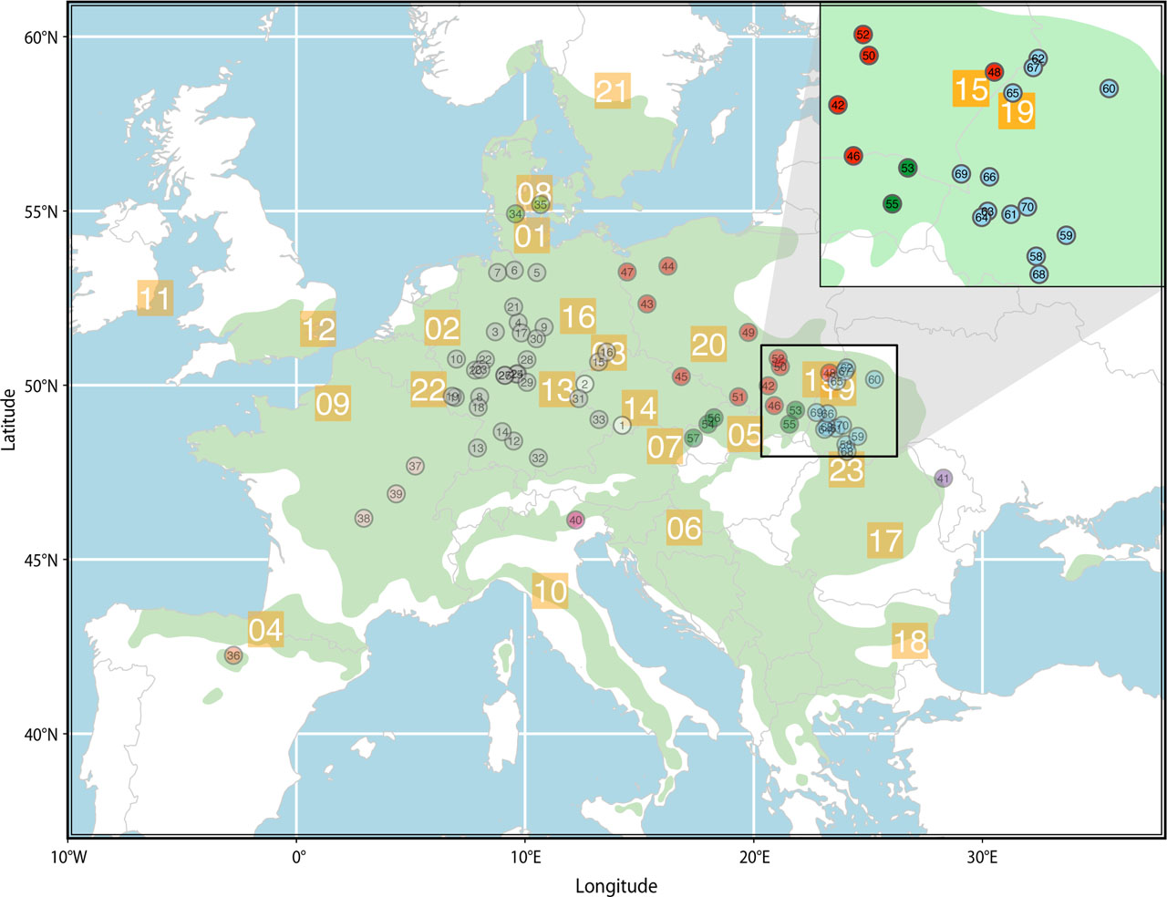
Figure 1.
Map of provenance trials (orange squares) from the 1993/95 series. The numbers in the orange squares correspond to the ID column in Table 1, indicating that the provenance trial Bu19_19 is marked as 19 on the map. Circles on the map represent the provenances used for the Bu19_19 provenance trial, with numbers in the circles corresponding to the ID column in Table 2. The transparent green area denotes the natural distribution area of Fagus sylvatica L. in Europe (source: https://www.euforgen.org)
Table 2.
General description of provenances used at Bu19_19 provenance trial (adapted from information provided by the Institute for Forest Genetics and Forest Tree Breeding, Großhansdorf, Germany). CO – Country of origin (CZ – Czech Republic, DE – Germany, DK – Denmark, ES – Spain, FR – France, IT – Italy, MD – Moldova, PL – Poland, UA – Ukraine), ID – provenance designation according to Figure 1, Ort – Provenance (ecotype), VersNr – provenance designation according to documentation, LAT – Latitude (degrees and minutes), LON – Longitude (degrees and minutes), ALT – Altitude (meters above sea level).
| CO | ID | Ort | VersNr | LAT | LON | ALT | CO | ID | Ort | VersNr | LAT | LON | ALT |
|---|---|---|---|---|---|---|---|---|---|---|---|---|---|
| 1 | 2 | 3 | 4 | 5 | 6 | 7 | 8 | 9 | 10 | 11 | 12 | 13 | 14 |
| CZ | 1 | Cesky serumlov | 9001 | 48°51′N | 14°15′E | 750 | ES | 36 | Anguiano | 8984 | 42°15′N | 2°45′W | 950 |
| 2 | Kladska | 9007 | 50°2′N | 12°37′E | 690 | FR | 37 | Val desmons | 9018 | 47°41′N | 5°12′E | 440 | |
| DE | 3 | Glashutte | 8771 | 51°32′N | 8°42′E | 440 | 38 | Colettes | 9020 | 46°11′N | 2°57′E | 575 | |
| 4 | Seelzerthurm | 8786 | 51°48′N | 9°42′E | 360 | 39 | Planoise | 9021 | 46°53′N | 4°22′E | 535 | ||
| 5 | Busschewald | 8938 | 53°14′N | 10°31′E | 75 | IT | 40 | Vallorch | 9049 | 46°8′N | 12°13′E | 1150 | |
| 6 | Harsefeld | 8939 | 53°18′N | 9°32′E | 43 | MD | 41 | Ungeny MLD | M1 | 47°20′N | 27°78′E | 36 | |
| 7 | Ostenholz-Scharmbeck | 8940 | 53°14′N | 8°48′E | 25 | PL | 42 | Brzesko, Tymowa | 161 | 49°59′N | 20°38′E | 350 | |
| 8 | Kirchheimbolanden | 8941 | 49°40′N | 8°1′E | 400 | 43 | Swiebodzin PL-1 | 9051 | 52°20′N | 15°20′E | 170 | ||
| 9 | Oderhaus | 8942 | 51°40′N | 10°50′E | 710 | 44 | Swierczyna PL-9 | 9052 | 53°25′N | 16°15′E | 180 | ||
| 10 | Morbach | 8951 | 50°45′N | 7°0′E | 660 | 45 | Ladek Zdroj PL3/PL2 | 9053 | 50°15′N | 16°50′E | 965 | ||
| 11 | Hermeskeil | 8952 | 49°39′N | 6°57′E | 650 | 46 | Krynica | 9054 | 49°25′N | 20°54′E | 850 | ||
| 12 | Ehingen | 8953 | 48°24′N | 9°30′E | 620 | 47 | Gryfino | P2 | 53°15′N | 14°28′E | 37 | ||
| 13 | Ettenheim | 8954 | 48°12′N | 7°55′E | 445 | 48 | Narol | P4 | 50°21′N | 23°19′E | 273 | ||
| 14 | Herrenberg | 8955 | 48°40′N | 9°0′E | 500 | 49 | Mlynary | P5 | 51°31′N | 19°46′E | 183 | ||
| 15 | Heinzebank | 8956 | 50°40′N | 13°13′E | 540 | 50 | Staszow | P6 | 50°32′N | 21°10′E | 176 | ||
| 16 | Tharandt | 8957 | 50°57′N | 13°34′E | 365 | 51 | Sucha | P7 | 49°40′N | 19°20′E | 400 | ||
| 17 | Bovenden | 8958 | 51°30′N | 9°50′E | 375 | 52 | Lagow | P8 | 50°46′N | 21°4′E | 295 | ||
| 18 | Elmstein-Sud, Appenthal | 8959 | 49°22′N | 7°57′E | 405 | SK | 53 | Medzilaborce-kos | 8943 | 49°17′N | 21°50′E | 426 | |
| 19 | Osburg | 8960 | 49°41′N | 6°49′E | 540 | 54 | Trenk In | 8945 | 48°53′N | 18°0′E | 144 | ||
| 20 | Montabaur | 8961 | 50°26′N | 7°50′E | 313 | 55 | Zamutov | 8946 | 48°53′N | 21°34′E | 259 | ||
| 21 | Deister | 8962 | 52°15′N | 9°30′E | 175 | 56 | Lednike Rovne | 8947 | 49°4′N | 18°16′E | 257 | ||
| 22 | Dillenburg | 8963 | 50°44′N | 8°16′E | 500 | 57 | Smolenice | 8948 | 48°29′N | 17°22′E | 192 | ||
| DE | 23 | Hadamar | 8964 | 50°27′N | 8°4′E | 218 | UA | 58 | Uholka | U1 | 48°18′N | 23°62′E | 353 |
| 24 | Schluchtern | 8966 | 50°20′N | 9°40′E | 490 | 59 | Ust-Chorna | U2 | 48°32′N | 23°93′E | 686 | ||
| 25 | Sinntal | 8968 | 50°19′N | 9°38′E | 430 | 60 | Brody | U3 | 50°10′N | 25°17′E | 253 | ||
| 26 | Budingen | 8970 | 50°17′N | 9°7′E | 198 | 61 | Svaliava – 1 | U4 | 48°46′N | 22°96′E | 678 | ||
| 27 | Budingen | 8971 | 50°17′N | 9°7′E | 225 | 62 | Roztochchia | U5 | 49°90′N | 23°64′E | 330 | ||
| 28 | Bad Salzungen | 8994 | 50°44′N | 10°5′E | 555 | 63 | Mukachevo | U6 | 48°48′N | 22°72′E | 356 | ||
| 29 | Eisenach | 8995 | 50°5′N | 10°5′E | 615 | 64 | Svaliava – 2 | U7 | 48°44′N | 23°6′E | 949 | ||
| 30 | Ebeleben | 8996 | 51°20′N | 10°30′E | 315 | 65 | Zavadiv | U8 | 50°7′N | 23°38′E | 245 | ||
| 31 | Vohenstrauss | 8997 | 49°37′N | 12°21′E | 660 | 66 | Volovets | U9 | 48°71′N | 23°14′E | 717 | ||
| 32 | Kaufbeuren | 8998 | 47°55′N | 10°35′E | 700 | 67 | Rava-Ruska | U10 | 50°24′N | 23°59′E | 260 | ||
| 33 | Zwiesel | 8999 | 49°1′N | 13°14′E | 755 | 68 | Kobyletska Poliana | U11 | 48°6′N | 24°5′E | 587 | ||
| DK | 34 | Grasten, Buskmose | 8974 | 54°55′N | 9°35′E | 50 | 69 | Perechyn | U12 | 48°73′N | 22°45′E | 235 | |
| 35 | Glorup | 8975 | 55°11′N | 10°41′E | 70 | 70 | Mizhhiria | U13 | 48°51′N | 23°53′E | 627 |
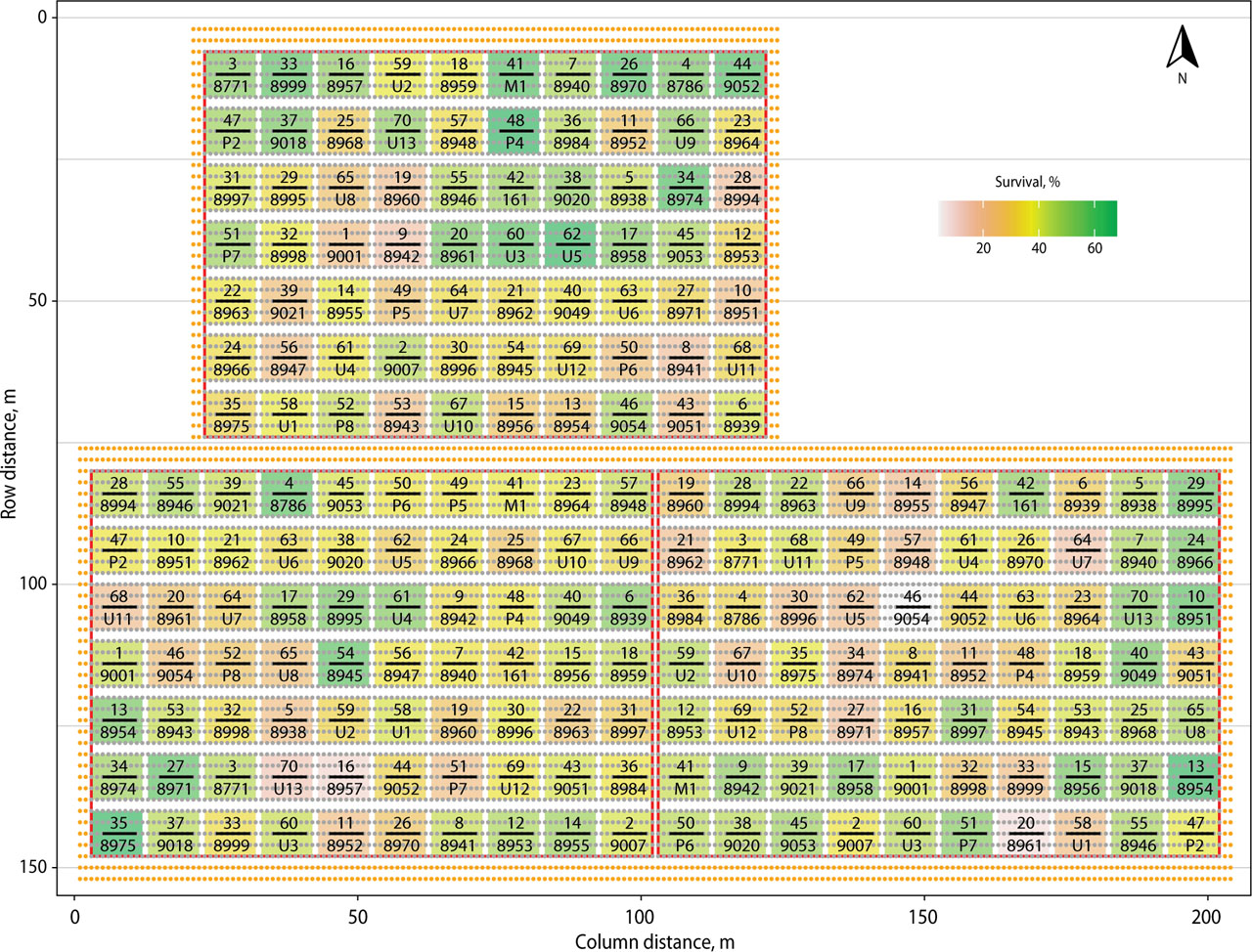
Figure 2.
Plan of the provenance trial Bu19_19 established in 1995 in Stradch Educational-Industrial Forestry Complex. Fill color, according to the scale, denotes the survival rate of provenances after 28 years of growth. The numerator and denominator of each plot denote the provenances according to the columns ID and VersNr in Table 2. The red line denotes the borders of complete randomized blocks, and gray dots denote planting sites (orange dots around blocks denote bordering rows). Block one is on top, blocks two and three are bottom left and right, respectively.
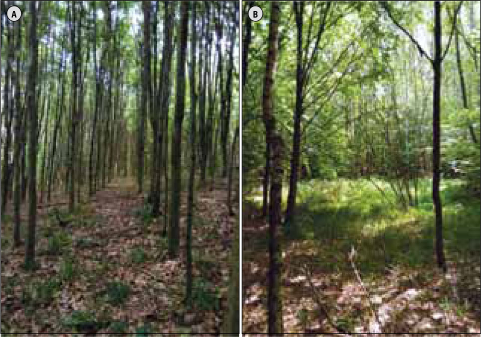
Figure 3.
Plots with high (A) and low (B) survival rate at the Bu19_19 provenance test trial in Ukrainian Roztochchia
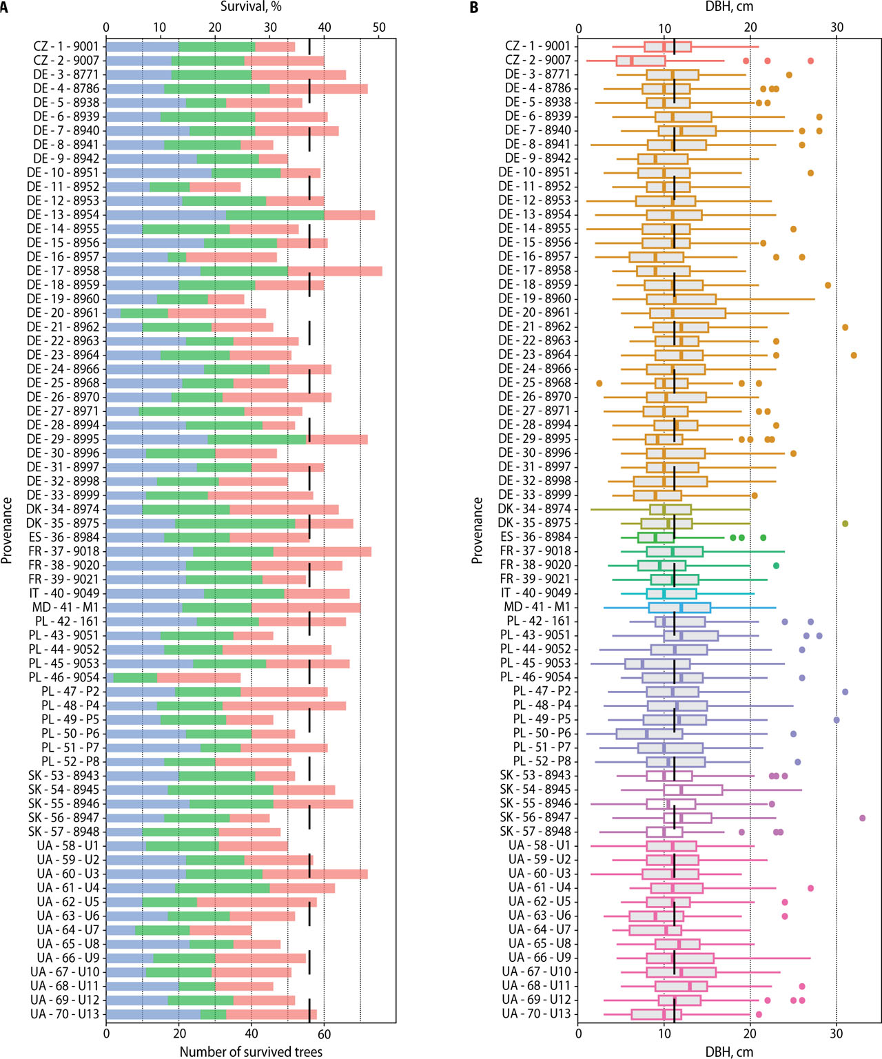
Figure 4.
Survival rate (A) and DBH (B) at the Bu19_19 provenance trial 28 years after planting. Provenances are labeled according to columns CO, ID, and VersNr in Table 2. Vertical dashed lines indicate grand mean values. In panel A, the colors red, green and blue represent blocks 1, 2 and 3 respectively.