
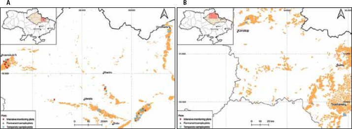
Figure 1.
Temporary, permanent sample plots and intensive monitoring plots at the maps of Kharkiv (A) and Sumy (B) regions
Table 1.
The distribution of the number of temporary sample plots by types of forest site conditions and site classes
| Site class | TFSC | Total | ||||
|---|---|---|---|---|---|---|
| A1 | A2 | B2 | C2 | C3 | ||
| Ia | – | 8 | 3 | 1 | 12 | |
| I | 5 | 10 | 1 | – | 16 | |
| II | 1 | 1 | – | – | – | 2 |
| Total | 1 | 6 | 18 | 4 | 1 | 30 |
Table 2.
Dynamic of climate indicators for two 30 years periods
| Point | Ty,°C | Py, mm | Ppos, mm | W | |||||||
|---|---|---|---|---|---|---|---|---|---|---|---|
| 1960-–1990 | 1990-–2020 | ΔT | 1960-–1990 | 1990-–2020 | ΔP | 1960-–1990 | 1990-–2020 | ΔPpos | 1960-–1990 | 1990-–2020 | |
| Zmiiv | 7.7 | 8.8 | 1.1 | 519 | 520 | 1 | 367 | 402 | 35 | 0.29 | 0.09 |
| Merefa | 7.7 | 8.8 | 1.1 | 519 | 520 | 1 | 367 | 402 | 35 | 0.29 | 0.09 |
| Krasnokutsk | 7.3 | 8.4 | 1.1 | 559 | 555 | –4 | 398 | 435 | 37 | 0.80 | 0.60 |
| Trostyanets’ | 7.0 | 8.2 | 1.2 | 587 | 580 | –7 | 423 | 461 | 38 | 1.21 | 1.02 |
| Sumy | 7.1 | 8.2 | 1.1 | 588 | 580 | –8 | 426 | 461 | 35 | 1.23 | 1.02 |
| Konotop | 7.1 | 8.3 | 1.2 | 598 | 589 | –9 | 433 | 466 | 33 | 1.32 | 1.04 |
Table 3.
Dynamic of climate indicators in 2000–2010 and 2010–2020
| Point | Ty, °C | Py, mm | Ppos, mm | W | ||||||||
|---|---|---|---|---|---|---|---|---|---|---|---|---|
| 2000-–2 | 2010-–2 | ΔT | 2000-–2 | 2010-–2 | ΔP | 2000-–2 | 2010-–2 | ΔPpos | 2000-–2 | 2010-–2 | ||
| Zmiiv | 9.2 | 9.5 | 0.4 | 521 | 511 | –10 | 398 | 378 | –20 | –0.15 | –0.49 | |
| Merefa | 8.8 | 9.5 | 0.7 | 536 | 511 | –25 | 417 | 378 | –39 | 0.17 | –0.49 | |
| Krasnokutsk | 8.4 | 9.1 | 0.7 | 571 | 544 | –27 | 451 | 410 | –41 | 0.68 | –0.02 | |
| Trostyanets’ | 8.1 | 8.8 | 0.6 | 598 | 563 | –35 | 477 | 432 | –45 | 1.10 | 0.35 | |
| Sumy | 8.1 | 8.8 | 0.6 | 598 | 563 | –35 | 477 | 432 | –45 | 1.10 | 0.35 | |
| Konotop | 8.3 | 8.9 | 0.7 | 605 | 564 | –41 | 480 | 428 | –52 | 1.12 | 0.30 | |
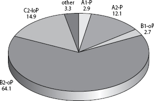
Figure 2.
Distribution of the area of Scots pine stands in the forest-steppe part of Kharkiv region by forest types
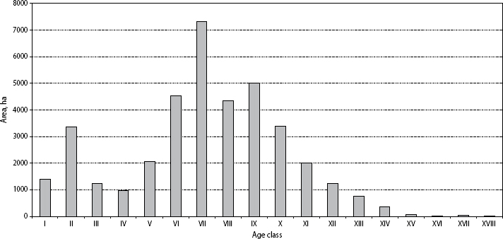
Figure 3.
Distribution of area of Scots pine stands by 10-year age classes in the forest-steppe part of Kharkiv region
Table 4.
Mean mensuration indicators and standard errors of Scots pine stands in the forest-steppe part of Kharkiv region in 2017 (according to the ‘Forests of Ukraine’ Database)
| Forest type | N of plots | Mean mensuration indicators | |||||
|---|---|---|---|---|---|---|---|
| age, years | diameter, cm | height, m | growing stock, m3 ha-1 | relative density of stocking | site class | ||
| A1P | 637 | 60±1 | 20.8±0.3 | 16.7±0.2 | 300±4 | 0.74±0.01 | I.9 |
| A2-P | 1842 | 66±1 | 24.1±0.2 | 19.0±0.2 | 325±3 | 0.72±0.01 | I.5 |
| B1-oP | 509 | 69±1 | 23.9±0.4 | 18.5±0.3 | 310±5 | 0.73±0.01 | I.7 |
| B2-oP | 8824 | 66±1 | 25.7±0.1 | 20.0±0.1 | 340±2 | 0.72±0.01 | I.0 |
| C2-loP | 1992 | 70±1 | 29.1±0.1 | 22.1±0.1 | 360±2 | 0.70±0.01 | Ia.6 |
| Otder | 597 | 51±1 | 25.4±0.4 | 18.9±0.3 | 310±5 | 0.76±0.01 | I.2 |
| Total | 14401 | 66±1 | 25.8±0.1 | 20.0±0.1 | 338±1 | 0.72±0.01 | I.1 |
Table 5.
Productivity of Scots pine stands in the Forest-Steppe depending on forest site conditions and site class (average growing stock m3 ha-1) (according to ‘Forests of Ukraine’ Database)
| Site class | Types of forest site conditions | On the average, m3 ha-1 | ||||||
|---|---|---|---|---|---|---|---|---|
| A1 | A2 | B1 | B2 | C1 | C2 | D2 | ||
| Ib | 364±61 | 379±25 | 363±0 | 412±6 | 350±36 | 422±7 | 281±0 | 415±4 |
| Ia | 352±12 | 410±5 | 374±17 | 405±2 | 275±23 | 338±4 | 374±24 | 383±2 |
| I | 340±5 | 374±3 | 356±7 | 302±2 | 229±10 | 365±4 | 330±10 | 319±1 |
| II | 280±5 | 256±2 | 287±6 | 320±4 | 201±11 | 299±6 | 309±11 | 309±6 |
| III | 170±6 | 237±8 | 230±7 | 215±6 | 78±6 | 195±13 | 191±8 | 207±3 |
| IV | 136±10 | 148±16 | 124±20 | 102±10 | 54±7 | 38±6 | – | 94±5 |
| Total | 300±4 | 325±3 | 310±5 | 340±2 | 208±2 | 348±2 | 312±2 | 338±1 |
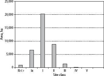
Figure 4.
Distribution of Scots pine stand area by site classes in the forest-steppe part of Kharkiv region
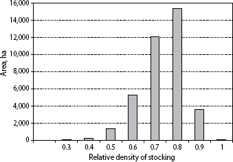
Figure 5.
Distribution of Scots pine stands area in the forest-steppe part of Kharkiv region by relative density of stocking
Table 6.
Dynamics of Scots pine stands indicators in the intensive monitoring and permanent sample plots
| Forest enterprise | Latitude/ longitude | TFSC | Year | Age, years | M, m3ha-1 | P | G, m2ha-1 | Site class | Mc, m3ha-1 |
|---|---|---|---|---|---|---|---|---|---|
| 1 | 2 | 3 | 4 | 5 | 6 | 7 | 8 | 9 | 10 |
| SE “Zhovtneve FE” | N 49.90097° E 36.23000° | B2 | 2011 | 60 | 410 | 0.69 | 34.1 | Ia | 1.1 |
| B2 | 2015 | 64 | 428 | 0.70 | 34.5 | Ia | 1.3 | ||
| B2 | 2019 | 68 | 441 | 0.69 | 35.0 | Ia | 4.6 | ||
| SE “Zhovtneve FE” | N 49.83047° E 35.72024° | B2 | 2011 | 55 | 397 | 0.73 | 35.4 | Ia | 0.0 |
| B2 | 2015 | 59 | 432 | 0.77 | 37.9 | Ia | 6.6 | ||
| B2 | 2019 | 63 | 453 | 0.79 | 39.2 | Ia | 27.0 | ||
| NNP “Slobozhansky” | N 50.07916° E 35.21080° | B2 | 2014 | 40 | 286 | 0.63 | 29.0 | Ia | 0.4 |
| B2 | 2018 | 44 | 318 | 0.68 | 32.1 | Ia | 1.1 | ||
| SE “Skrypaivske SRFE” | N 49.75801° E 36.63940° | B2 | 2013 | 93 | 442 | 0.70 | 36.1 | I | 4.5 |
| B2 | 2017 | 97 | 425 | 0.70 | 35.0 | I | 46.4 | ||
| B2 | 2021 | 101 | 423 | 0.65 | 33.8 | I | 58.0 | ||
| NNP “Slobozhansky” | N 50.07299° E 35.23105° | B2 | 2016 | 85 | 371 | 0.61 | 30.4 | I | 5.9 |
| B2 | 2020 | 89 | 392 | 0.63 | 31.9 | I | 7.9 | ||
| NNP “Slobozhansky” | N 50.08953° E 35.25167° | B2 | 2016 | 70 | 405 | 0.82 | 38.8 | I | 3.0 |
| B2 | 2021 | 75 | 442 | 0.85 | 41.6 | I | 4.4 | ||
| NNP “Slobozhansky” | N 50.07164° E 35.23530° | B2 | 2016 | 120 | 529 | 0.88 | 44.2 | II | 16.5 |
| B2 | 2020 | 124 | 543 | 0.88 | 44.5 | II | 16.3 | ||
| NNP “Slobozhansky” | N 50.05740° E 35.22488° | B2 | 2016 | 80 | 338 | 0.65 | 30.6 | I | 15.5 |
| B2 | 2020 | 84 | 360 | 0.64 | 31.6 | I | 19.2 | ||
| NNP “Slobozhansky” | N 50.06153° E 35.22173° | B2 | 2016 | 110 | 565 | 0.90 | 46.0 | II | 0.4 |
| B2 | 2020 | 114 | 596 | 0.91 | 46.5 | II | 0.0 | ||
| NNP “Slobozhansky” | N 50.06005° E 35.21920° | A1–2 | 2016 | 48 | 113 | 0.33 | 13.7 | II | 0.0 |
| A1–2 | 2020 | 52 | 125 | 0.32 | 13.9 | I | 1.7 | ||
| NNP “Slobozhansky” | N 50.03659° E 35.24382° | C2 | 2016 | 60 | 470 | 0.80 | 39.6 | Ia | 9.2 |
| C2 | 2021 | 65 | 502 | 0.82 | 41.2 | Ia | 16.3 | ||
| NNP “Slobozhansky” | N 50.05129° E 35.25843° | C2 | 2016 | 100 | 607 | 0.89 | 46.8 | Ia | 36.5 |
| C2 | 2021 | 105 | 625 | 0.87 | 47.2 | Ia | 34.1 | ||
| NNP “Slobozhansky” | N 50.04390° E 35.23067° | C2 | 2016 | 95 | 405 | 0.75 | 35.3 | I | 27.4 |
| C2 | 2021 | 100 | 411 | 0.74 | 35.7 | I | 45.0 | ||
| SE “Skrypaivske SRFE” | N 49.27504° E 36.54960° | A2 | 2012 | 75 | 468 | 0,9 | 44,2 | I | 1.8 |
| A2 | 2018 | 81 | 449 | 0,85 | 41,9 | II | 5.2 | ||
| SE “Skrypaivske SRFE” | N 49.87952° E 36.62420° | B2 | 2012 | 55 | 503 | 0,92 | 45,5 | Ia | 15.7 |
| B2 | 2018 | 61 | 501 | 0,85 | 42,9 | Ia | 21.3 | ||
| SE “Skrypaivske SRFE” | N 49.67125° E 36.58750° | C2 | 2012 | 50 | 432 | 0,89 | 42,8 | Ia | 7.4 |
| C2 | 2018 | 56 | 467 | 0,91 | 44,8 | Ia | 9.5 |
Table 7.
Health condition dynamic at monitoring and permanent sample plots
| Forest enterprise | Latitude/ longitude | Year | Health condition index | Part of damaged trees, % | Part of dead trees, % | |
|---|---|---|---|---|---|---|
| without dead trees | with dead trees | |||||
| SE “Zhovtneve FE” | N 49.90097° E 36.23000° | 2011 | 1.12±0.06 | 1.18±0.08 | 60.6 | 1.5 |
| 2015 | 1.19±0.06 | 1.28±0.09 | 58.5 | 1.9 | ||
| 2019 | 1.16±0.05 | 1.33±0.11 | 39.1 | 4.5 | ||
| SE “Zhovtneve FE” | N 49.83047° E 35.72024° | 2011 | 1.02±0.02 | 1.02±0.02 | 15.7 | 0.0 |
| 2015 | 1.14±0.05 | 1.27±0.09 | 12.8 | 3.4 | ||
| 2019 | 1.16±0.04 | 1.39±0.11 | 10.6 | 5.6 | ||
| NNP “Slobozhansky” | N 50.07916° E 35.21080° | 2014 | 1.04±0.02 | 1.07±0.04 | 1.7 | 0.9 |
| 2018 | 1.04±0.02 | 1.11±0.05 | 1.8 | 1.7 | ||
| SE “Skrypaivske SRFE” | N 49.75801° E 36.63940° | 2013 | 1.13±0.04 | 1.19±0.07 | 9.5 | 1.6 |
| 2017 | 1.14±0.05 | 1.57±0.15 | 8.6 | 10.8 | ||
| 2021 | 1.42±0.09 | 2.08±0.21 | 5.8 | 15.6 | ||
| NNP “Slobozhansky” | N 50.07299° E 35.23105° | 2016 | 1.04±0.03 | 1.21±0.12 | 4.4 | 4.3 |
| 2020 | 1.24±0.08 | 1.32±0.11 | 11.1 | 2.1 | ||
| NNP “Slobozhansky” | N 50.08953° E 35.25167° | 2016 | 1.02±0.02 | 1.07±0.05 | 1.2 | 1.2 |
| 2021 | 1.08±0.03 | 1.13±0.06 | 6.3 | 1.2 | ||
| NNP “Slobozhansky” | N 50.07164° E 35.23530° | 2016 | 1.03±0.03 | 1.14±0.12 | 5.9 | 2.9 |
| 2020 | 1.30±0.10 | 1.44±0.15 | 17.6 | 3.0 | ||
| NNP “Slobozhansky” | N 50.05740° E 35.22488° | 2016 | 1.22±0.07 | 1.81±0.21 | 6.0 | 13.8 |
| 2020 | 1.17±0.06 | 1.80±0.22 | 0.0 | 14.3 | ||
| NNP “Slobozhansky” | N 50.06153° E 35.22173° | 2016 | 1.31±0.07 | 1.44±0.12 | 7.7 | 3.7 |
| 2020 | 1.26±0.06 | 1.26±0.06 | 13.0 | 0.0 | ||
| NNP “Slobozhansky” | N 50.06005° E 35.21920° | 2016 | 1.09±0.05 | 1.09±0.05 | 0.0 | 0.0 |
| 2020 | 1.69±0.12 | 1.90±0.21 | 27.6 | 6.5 | ||
| NNP “Slobozhansky” | N 50.03659° E 35.24382° | 2016 | 1.10±0.03 | 1.42±0.11 | 2.0 | 7.5 |
| 2021 | 1.14±0.04 | 1.66±0.15 | 4.3 | 11.4 | ||
| NNP “Slobozhansky” | N 50.05129° E 35.25843° | 2016 | 1.04±0.02 | 1.52±0.18 | 1.8 | 11.1 |
| 2021 | 1.13±0.04 | 1.67±0.20 | 10.7 | 11.1 | ||
| NNP “Slobozhansky” | N 50.04390° E 35.23067° | 2016 | 1.07±0.04 | 1.58±0.20 | 10.9 | 11.5 |
| 2021 | 1.11±0.04 | 1.82±0.22 | 17.4 | 16.4 | ||
| SE “Skrypaivske SRFE” | N 49.27504° E 36.54960° | 2012 | 1.07±0.02 | 1.22±0.05 | 6.8 | 0.4 |
| 2018 | 1.19±0.04 | 1.25±0.06 | 7.2 | 1.4 | ||
| SE “Skrypaivske SRFE” | N 49.87952° E 36.62420° | 2012 | 1.11±0.03 | 1.32±0.07 | 7.4 | 5.2 |
| 2018 | 1.24±0.06 | 1.51±0.11 | 8.1 | 6.7 | ||
| SE “Skrypaivske SRFE” | N 49.67125° E 36.58750° | 2012 | 1.12±0.03 | 1.26±0.06 | 6.5 | 3.6 |
| 2018 | 1.14±0.04 | 1.32±0.07 | 6.8 | 4.4 | ||