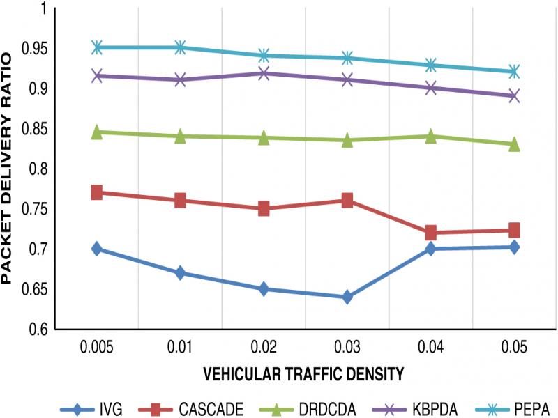
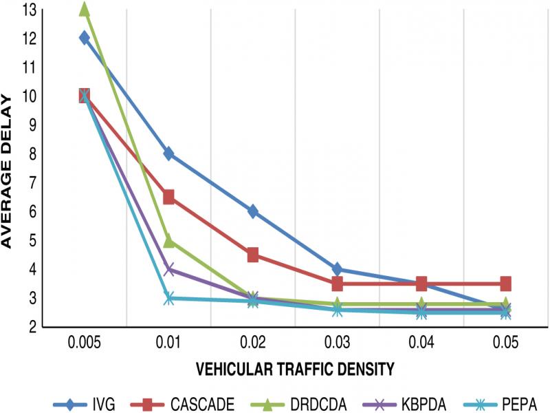
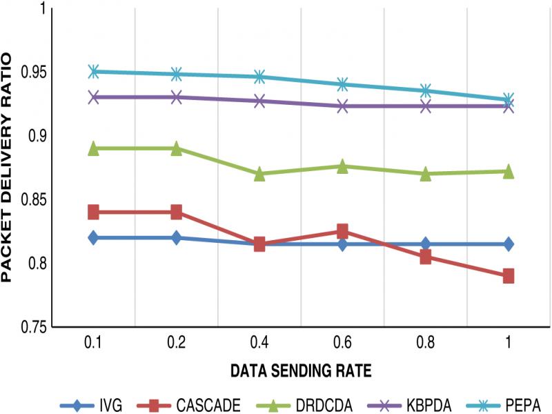
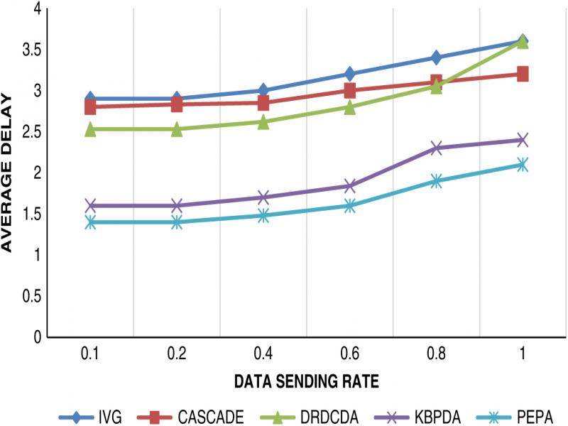
Structure-free vehicular ad-hoc networks (VANETs) exchange information through roadside units (RSUs) using IEEE 802.11p at 5.9 GHz. To make the journey experience safe and secure for the user, we need to ensure real-time information to road users on the highway or city scenario (S Al-Sultan et al., 2014; Schoch et al., 2008). Figure 1 indicates the basic communication module used for the propagation of information of the cluster to the end user. Cluster is required to overcome the issue of message storm in VANETs (Bali et al., 2014; Dietzel et al., 2014; Kumar et al., 2019). There exist many routing protocols in mobile ad-hoc networks, but they are not directly applicable to VANETs (Sharma and Kumar, 2016).
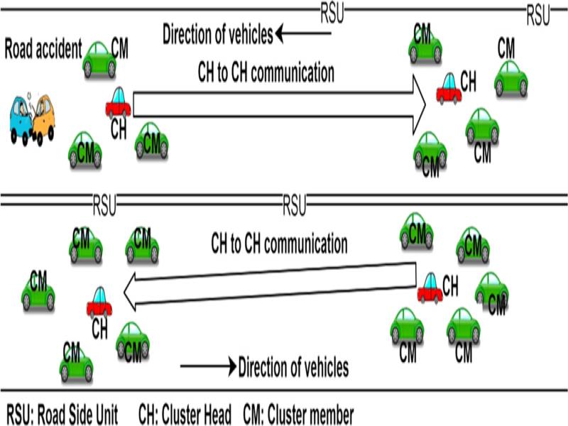
Figure 1:
Basic clustering communication model in VANET.
Researchers contributed to the area of structured aggregation (Bilal et al., 2014; Wischhof et al., 2003) but it does not find its scope in real-life situations. Smart data aggregation method aggregates on the basis of vehicle direction, road speed limitation, and duplicate packet removal, but the mechanism does not support effective utilization of bandwidth (Allani et al., 2018, 2020). Data dissemination based on map splitting is created by building zones of relevance and extracting related data, but the basic issue of broadcast storm is not addressed (Allani et al., 2018). There were contributions in the area of structure-free aggregation, wherein there is a dynamic mechanism to propagate packets and make information available to the users through improved forwarding delay (Molina-Gil et al., 2014; Ibrahim and Weigle, 2008; Kumar and Dave, 2013). The information-centric networks are being replaced to ensure efficient communication in terms of efficient delivery and address the trust management issues of the network (Rathee et al., 2020). Another mechanism where a trust evaluation matrix is created to overcome denial of service attacks on the VANETs, addresses bandwidth optimization without compromising security (Poongodi et al., 2019). Still, there is a scope to provide probabilistic correctness of the aggregated packet. Moreover, the authenticity of the aggregated packet remains an issue that needs urgent addressing. Once an aggregate of the original information is created, it is difficult to check whether the packet created by the cluster head is undoubtedly the correct one. Hence, whenever aggregated information is created, it must be ensured for its probable correctness, and the validity of the cluster member to send information to the cluster head needs to be checked at the time of the creation of an aggregated packet and not later.
Our contribution
A probabilistic aggregation scheme in which correctness of the aggregated packet is proposed, here, a new parameter, called the probability of correctness of the information aggregated, is created. Now, the receiving cluster head is able to make a decision, whether the packet is to be relayed further or not, depending upon the value of the probability of correctness. Moreover, we are not interested to keep information propagating further for more than twice the range of communication in VANET, since older information is not useful to make any decision. At the same time, the value of the timer that helps in regeneration of the aggregated packet is fixed. This helps in regeneration of the packet in case nearby vehicles are not available. The timer helped in reducing the packet loss during propagation of information. PEPA helps in making a correct decision on whether to keep using the aggregated packet or drop it and at the same time improves average delay, packet delivery ratio, and aggregation accuracy in comparison to other available state-of-the-art techniques.
Related work
There are several aggregation schemes proposed in VANETs for fixed structures of road segments. As the distance from the segment increases, the accuracy of these packets is also reduced and applicability of the techniques is questioned. Moreover, it is not correctly measuring the situational information. To overcome this issue, structure-free aggregation schemes are developed using various methods such as semantic or syntactic.
Analysis of vehicular-density estimation through a fixed-length structure is not an accurate estimate even though all vehicles are in the communication range. If we take two continuous road segments, then we will find some area of the road without being covered in any road segment (Bilal et al., 2014). A fixed hierarchy traffic information system was developed based on average speed as a parameter (Wischhof et al., 2003). Here each vehicle is supposed to be equipped with a Global Positioning System (GPS) receiver and other related digital techniques that help in data processing. Data from the nearby nodes that have lots of similarities will be aggregated into one during aggregation in case it is a set of similar information (Nadeem et al., 2004). M. Caliskan et al. applied a road-segmentation approach to compare with different segments of parking spots and reduced the record size to 50 bytes per second (Caliskan et al., 2006). Moreover, this approach of hierarchical aggregation is as good as a tree-based approach. If the distance of information from the source is more, then the quality of information is doubtful. Lochert et al., (2008) implemented the usage of landmarks instead of quadtree structures. It is pointed out that the difficulty of implementing parking space applications is too large in comparison to building a traffic information system where the applicability of fixed hierarchy is questionable. Exchange of communication at a minimum overhead is implemented by Sleet et al. (2010) using a clustering scheme for VANETs. Lee et al. (2014) reduced redundant information in urban and highway scenarios. The identity of vehicles is ensured through the cluster code. Multihop aggregation takes into consideration a larger area over which data is to be disseminated (Ucar et al., 2014). The issue of disconnected networks and broadcast storms is addressed by Ucar et al. (2016) at different vehicle densities. The authors were left to address the issue of multihop stability in an urban scenario.
Lochert et al. (2007, 2010) overcome the problem of scalability using (Flajolet–Martin) FM sketch-based aggregation in VANETS. If distinct elements are calculated in large databases without data being passed multiple times, FM sketches are being used. This helps in removing the older information. Here a time stamp is considered and the Time-to-Live (TTL) parameter is used (Flajolet and Martin, 1985). Consideration of the TTL parameter is not a practical solution. The price for this feature is the loss of exact counting. Zekri et al. (2012) also rely upon duplicate insensitive data fusion using FM sketches. The goal is not to save bandwidth but to get the exact knowledge of previous information. However, work does not use the TTL-adapted parameter and leads to high storage requirements. Many traffic information-related components and variables are made available through the Kalman filter (Milojevic and Rakocevic, 2015) and these variables varied from application to application. It helped in identifying single observations and removing old aggregations in real time. Usage of clustering for the exchange of beacons and optimization in the last 2-hop route is conducted to achieve better results (Ji et al., 2016). It is come up that the major problem in VANET is to restrict the flow of several packets that leads to a broadcast storm. This problem can be overcome using clustering to create clusters and data aggregation. This work is also useful in the area of signal disruption in optical fiber communication (Kumar and Sharma*, 2020)
Proposed approach
The goal is to create a system for generating an aggregated packet of information that contains a parameter with probable correctness of the packet. Such a system makes the existing aggregation scheme more adaptable in real-life processing of packets as shown in Figure 2.
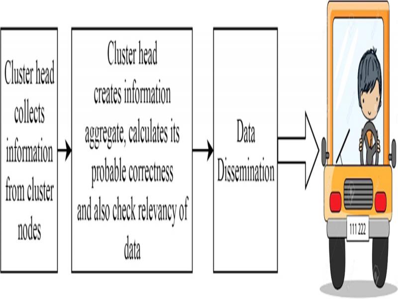
Figure 2:
Basic model for information flow.
The detailed working of Figure 2 is illustrated through a flow diagram of Figure 3. The authorization phase involves only those nodes in the network that are authorized by the certificate authority (CA). This phase is accomplished by authenticating the offline-registered nodes through the RSU. The RSU is responsible for examining the authenticity of the vehicle. If the vehicle proves to be authorized by CA, the vehicle is allowed to participate in the network. Otherwise, the vehicle is not certified to join the operating network. First, each vehicle is required to perform registration with the CA offline and then to get authorization from RSU in order to get operated within the network.
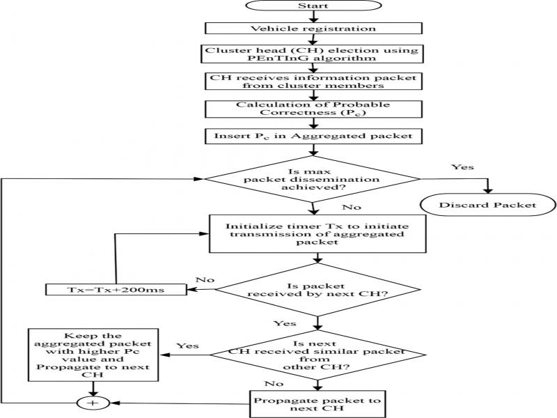
Figure 3:
Data aggregation and dissemination process.
The second phase of the proposed mechanism involves the clustering of nodes. To overcome problems of power consumption where consideration of extra battery level or the cost limitations are very much mitigated by selecting the group heads from the authenticated vehicles. In this phase, all authorized nodes are required to form the cluster based on the information registered in the database of the CA. Moreover, cluster heads are selected based on average speed, trust factor, neighborhood degree, and time-to-live parameters (Kumar et al., 2019). The nodes with the higher value of cluster head factor and high-performance results from previous communications are selected for clustering. There is at least one group head for each cluster. The formation of these clusters marks an advantageous feature of decreasing the burden on the RSU.
The next phase of the process is to collect the information packets from the cluster nodes and create an aggregated packet at the cluster head level. Here, a parameter probability of correctness is introduced to inform other cluster heads about the usefulness of the information packet. The desired value of this parameter should be as close to one as possible. To guarantee the correctness of an aggregated packet, the scheme verified the signature of each contributing vehicle as part of the cluster, and if any vehicle is found using wrong signatures, then the probability of correctness will be reduced, otherwise, we strive to get the probability of correctness as close to one as possible. In case eight vehicles are contributing to the aggregate, then, if a vehicle is found with the correct signature, probable correctness will be calculated as 1/8; in case one vehicle does not have the correct signature, then net probable correctness will be (1-1/8); this parameter will apply to both cities and highways The packet forwarded by the cluster head contains the field of the number of vehicles and probable correctness parameters. This will help the user to utilize the information in case the user is willing to do so, thereby decision-making becomes easier.
In case n be the number of vehicles involved in the creation of a packet, then the probability of correctness of each vehicle is given as . If k is the number of vehicles with incorrect signatures, then, the total probable correctness Pc of the aggregated packet is given as the algebraic sum of all probabilities of all correct signature vehicles, hence
Once a packet is disseminated to the next cluster head with correctness information as part of the aggregated packet, then it happens that the next cluster head might have received similar packets from other existing cluster heads also, so the next CH has to decide which packet to keep and which one to drop. This decision is taken based on the probable correctness level of the received packet. In case multiple packets of similar information are received, then higher the value of probable correctness, the larger is the probability of selection of that aggregated packet in order to disseminate the information further. This dissemination of the information is also made probabilistic: transmission of the aggregated packet will be less in case the distance of the aggregate from the source cluster head is increased. This follows equations (2) and (3) as given below.
In case D is a random variable, indicating the distance from source vehicle S and in case d denotes the distance from source aggregator vehicle to the current location of the aggregated packet with some cluster head, then:
(2)where R is the range of communication using IEEE802.11p.Tx is the timer value related to the vehicle with distance D (Kumar and Dave, 2013), then:
(3)where ɛ > 0 and Tmax = 200msThe aggregated packet consists of the average speed of the cluster, location of origin of the packet, information, time stamp, and correctness value as part of it. The aggregated packet will not be rebroadcasted further in case the maximum propagation distance is reached. Moreover, in case distance from the source of the packet is increased, then several transmissions will also be reduced, or in other words, this is made probabilistic. Equations (2) and (3) put a limit on the number of retransmissions of the aggregated packet. It is found that older information is not useful in VANETs, and hence as and when packets become older, they are no more needed in the communication process and communication is continued with fresh packets. The loop ends when the maximum distance of dissemination is achieved for an aggregated packet, or the aggregated packet becomes older. Now, fresh aggregated packets take part in the communication process and the older ones keep on getting eliminated from the dissemination process. The aggregated packet dissemination remains in the communication process as long as the maximum dissemination range is not reached, i.e., twice the range of communication. The packet gets discarded if the condition becomes true, and hence the loop ends if there are no packets to disseminate further.
Simulations and results
This section evaluates the performance of PEPA through simulations. The prime objective of the data aggregation process is to save bandwidth. To analyze the performance of the probabilistic aggregation in terms of packet delivery ratio, average delay, and aggregation accuracy, several NS 2 simulations are conducted and Table 1 is used to carry out the simulation process. This section presented a detailed simulation analysis of the proposal for a road of a length of 2.5 km. There are six lanes considered for simulation, with an equal number of lanes in the forward and backward direction.
Table 1.
Simulation parameters.
| Parameter | Value or type |
|---|---|
| Simulation area | 2500 m × 2500 m |
| Simulation time | 600s |
| Radio model | Two-ray ground |
| MAC layer | IEEE802.11 |
| Number of vehicles | 50–400 |
| Vehicle speed | 40–120 km/h |
| Constant bit rate (CBR rate) | 1–4 packet/s |
| Vehicle communication range | 500 m |
| Bandwidth | 20Mbps |
| Data packet size | 500–2,500 byte |
| Cache replacement policy | FIFO |
| Mobility model | Manhattan |
| Traffic environment | Urban |
| Number of lanes | 4–8 |
| Traffic type | Multimodal |
| Routing protocol | AODV |
| Number of simulation runs | 10 |