
Introduction
Around the turn of the millennium, Michael E. Moseley wrote that ‘archaeology can no longer afford to treat ancient natural disasters as curios of the past’ (Moseley, 2000: 223). Appropriately, then, archaeological investigation into hazards and disasters has increased multifold in the decades which have since passed (Faas & Baarios, 2015). Subdisciplines such as archaeoseismology (Sintubin, 2011), archaeological volcanology (Riede et al., 2020) and tectonic archaeology (Barnes, 2021) have emerged, among other examples. Some studies have also delved into the less well-defined archaeology of landslides (e.g., Garduño-Monroy et al., 2020; Gerrard et al., 2021; Niculiţă, Mărgărinta & Santangelo, 2016; Pappalardo et al., 2018; etc.), a form of geohazard that is particularly common in Sweden compared to other types of similarly destructive events, shaping the rural landscapes in which they often occur. Although ancient landslides have featured in Swedish archaeological studies of the prehistoric and medieval periods (e.g., Algotsson, 2000; Hernek, 2004; Larsson & Dury, 2022; Nordström & Lindeblad, 2016; etc.), sites and landscapes impacted by landslides in the post-medieval period have remained largely unstudied.
Further, research into both past disasters overall and landslides specifically has often focussed on the greatest and most lethal catastrophes. Events on the other side of the spectrum, those which are smaller on both the temporal and spatial scales, are somewhat understudied. This is partially because, even in the case of major disasters, the geoarchaeological record is often fragmentary, and data resolution is a frequent issue (Riede, 2014: 338). Some such large-scale events may have left behind for example region-spanning stratigraphic layers of volcanic tephra (Riede & Thastrup, 2013; Riede et al., 2020) or tsunami deposits (Barnes, 2017; Nyland, Walker & Warren, 2021; Walker et al., 2020), but that is not always the case. Hyperlocal events, however destructive to both individuals and wider communities, are even more frequently lost in the surging cacophony of the past. These have nonetheless been disasters. There are numerous competing definitions of the term ‘disaster’; within the context of this paper, I have chosen to use that put forward by the United Nations Office for Disaster Risk Reduction (UNDRR), which defines a disaster as:
… a serious disruption of the functioning of a community or a society at any scale due to hazardous events interacting with conditions of exposure, vulnerability and capacity, leading to one or more of the following: human, material, economic and environmental losses and impacts. (UNDRR, n.d.)
The UNDRR further defines disaster damage as ‘the total or partial destruction of physical assets, the disruption of basic services and damages to sources of livelihood in the affected area’ and disaster impact as the total effect of such an event, which may include ‘death, injuries, disease and other negative effects on human physical, mental and social well-being’ (n.d.). The key phrase here is ‘at any scale’. The human aspects of such incidents—the short-term impacts, the personal loss, the communal suffering, and the subsequent recovery—can easily disappear entirely from view or appear trivial. As stated by Torrence and Grattan: ‘… catastrophic cultural disaster in the immediate short term appears as nothing of the sort when considered over a longer time scale as the landscape is recolonised and utilised afresh’ (2002: 9).
Historical archaeology has the potential to highlight events such as these, combining the fragmentary geoarchaeological record with textual and cartographic sources. Some recent studies abroad have highlighted this potential (e.g., Fernández, Moshenska & Iriarte, 2019; Gerrard et al., 2021). In this paper, I focus on a case study of the 1703 Skrehall landslide, an event which caused no known fatalities but on the other hand had an extensive impact on the local agrarian landscape. I further employ the concept of the ‘disasterscape’ as defined by Kapur (2010) in an attempt to approximate some understanding of the lived experience of the disaster and its aftermath.
Disasterscapes
What might be called ‘-scape theory’, i.e., various clever variations on the concept of ‘landscape’, has been popular in many different disciplines for decades (Gold, 2002). The encyclopaedic website Wiktionary includes no less than 158 different English words suffixed with ‘-scape’, and no doubt more could be found. Many of these have a neutral or even positive ring to them; ruralscapes, cityscapes, waterscapes, seascapes, riverscapes, mindscapes, and so on. The ‘disasterscape’ is different. As coined by the scholar Anu Kapur in her 2010 book Vulnerable India, the disasterscape is anything but positive. To use Kapur’s own words, somewhat condensed:
The visual, acoustic and olfactory aura emanating from any disasterscape is distinct. There are the mangled limbs, the distorted bodies, the sounds of despair, the cry of pain, the stench of decay and the odor of putrefaction. Part and parcel of the disasterscape are the depressed women and children trying to keep their heads above the raging waters or rubble, farmers watching crops decay, cattle drown and seeds submerge. […] With a human face of misery and despair, the first impact of a disasterscape is a staggering disbelief. […] In contrast to the relish for the sublime, the disasterscape evokes extreme feelings, ranging from helplessness and anger, to a desire to respond, to reach out in every possible way to heal. […] There are features that delve deeper than the surface; these are the scars that etch on the minds of people. (Kapur, 2010)
The disasterscape is both the moment of the disaster and the space in which it occurs, the disaster zone if you will, to which the sensorial experiences are key. It is the immediate chaos, a ‘gaping wound that pleads for quick repair and relief’ (Kapur, 2010), but also the volunteers that come to help, the makeshift hospitals, the refugee camps, and so on. It is the ruins but also the cleared rubble. It ‘can and has been photographed, sketched and mapped’ (Kapur, 2010), and it is a commodity to be sold, politicised, and corrupted. This instance in space and time, this ‘place where human life is lost or damaged, relationships ripped and livelihoods disrupted’ (Kapur, 2010), is something that I believe archaeology at times struggles to accurately capture in its general preference of longue durée perspectives over the histoire événementielle.
Although Kapur’s usage of the disasterscape was originally intended to define the condition of the modern Indian subcontinent, stuck in a seemingly endless vortex of disasters, she left the door open for its usage elsewhere. I believe the term has utility in other regions and periods as well. It can help to visualise the aforementioned ‘visual, acoustic and olfactory’ (Kapur, 2010) aspects of a long-forgotten disaster and to imagine the radical spatial changes it may have caused. One such past disasterscape can be traced among the hamlets of Western Sweden in the early days of the long eighteenth century; that of the Skrehall landslide, which occurred around 8 o’clock in the evening on 15 September 1703.
The Landslide
The landslide site is today located just south of the locality Sjuntorp in the municipality of Trollhättan, Västra Götaland County, Sweden (Figure 1). Historically, it was situated right on the border between the Westrogothian parishes of Rommele and Fors in Flundre Hundred. The majority of the area belonged to the hamlet Ålstad, but the neighbouring hamlets Fors and Solberga were impacted as well. The landslide’s most notable feature today is a long, elevated scarp (Figure 2), marked by a steep slope surrounded on both sides by plateaus of farmland, which runs from north–west to south–east, passing right over the parish boundary, for the length of about a kilometre, almost parallel with a deep creek ravine to its south–west. It becomes less distinct the further south it goes; at its peak, the height of the scarp slope between the two plateaus is c. 5 m. Also running parallel, on the lower plateau between the ravine and the scarp, is an elongated depression, a hollow or rift formed by the slump of the landslide, with a varying width of 10–30 m and a maximum depth of c. 1 m. The nearby creek is a minor branch of Syltebäcken, in turn a tributary of Slumpån, which empties into the Göta River. The ravine landscape is marked by agriculture; the highlands are typically farmed while the ravines are used for cattle pasturage. Such is also the case with this site. Centuries of farming have smoothed out and eroded the once sharp edges of the scarp.
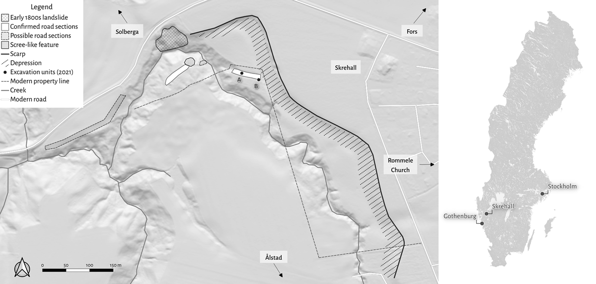
Figure 1
Map of the landslide site, with key features and its location within Sweden marked. Source: Paula Molander (2023).
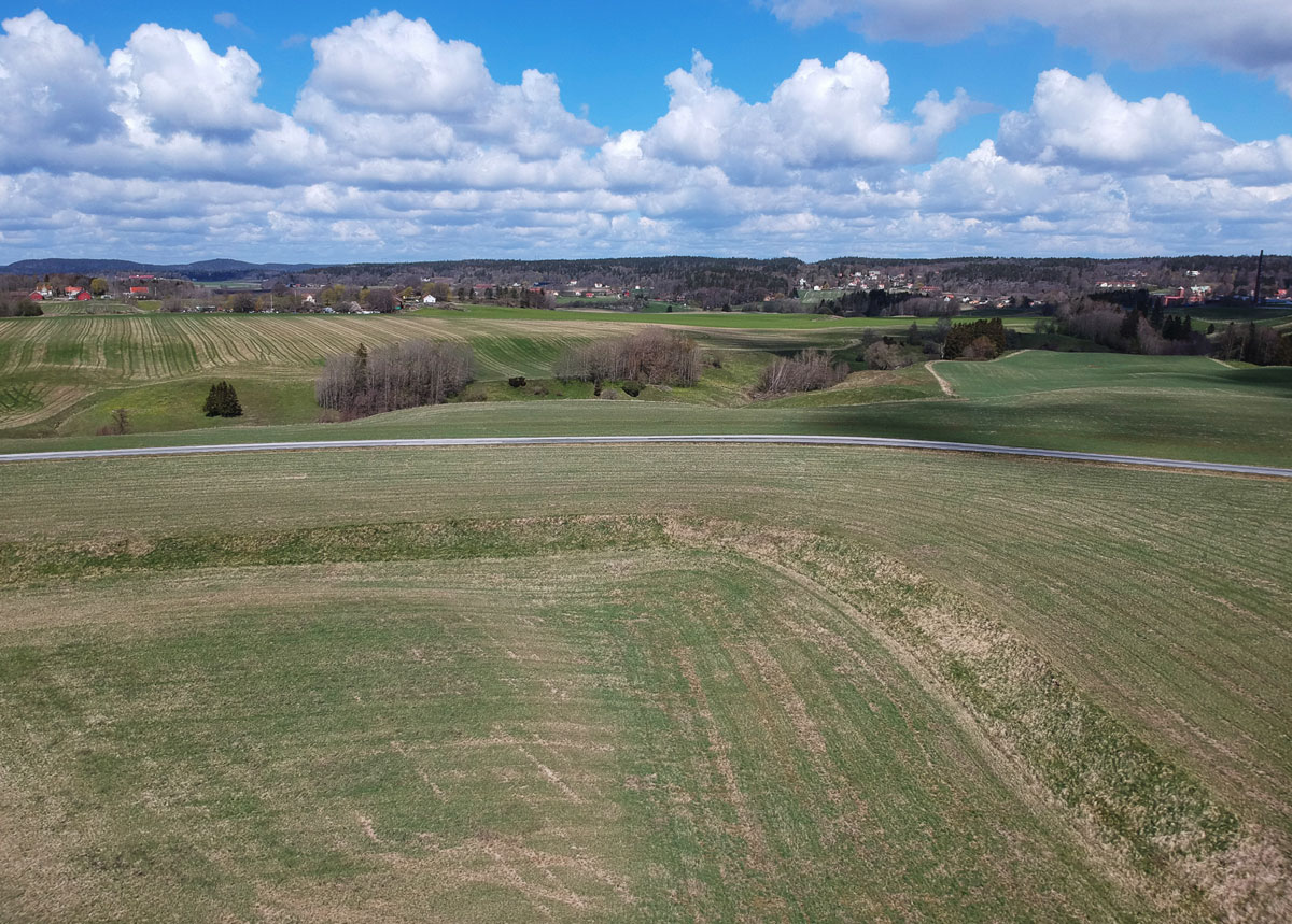
Figure 2
Drone photograph, showing the north-eastern bend of the landslide scarp, with the slope and depression below. The camera faces the north-east. Photo: Paula Molander (2021).
The landslide is poorly understood from a geological point of view; the landslide scarp has, for example, not been surveyed and included in the extensive landslide inventories of the Geological Survey of Sweden (SGU) and the Swedish Geotechnical Institute (SGI). The event, in fact, seems wholly forgotten today; no place name indicative of a disaster remains in use, and neither the local heritage society nor the present-day landowners appear to have been aware of it. It is only through the historical source material and archaeological fieldwork that the site can be recognised for what it is and what its impact was.
The historical source material in question is almost entirely cartographic, consisting of two separate maps that both depict the 1703 event, along with their written descriptions and legends. They are, in practice, versions of the same map but drawn in different styles. One is kept in the cartographic collections of the Lund University Library (Figure 3; Anonymous, 1703a). The other one comes from the archives of the Swedish National Land Survey and is now kept in the National Archives’ depot in Arninge (Figure 4; Kempensköld, 1703). For the sake of ease, these two versions, fundamentally the same but with marked differences, will be referred to by their place of storage. The ‘Lund map’ is less accurate in detail than the ‘Arninge map’; for example, it is missing the numerals indicated in its own legend. The Arninge map also appears to be more accurate in its depiction of roadways, fences and geographic features, while the Lund map is missing some of the text found in its counterpart. Therefore, the Arninge map is the main basis of this article, and all textual citations from the map legend derive from it. While the Lund map is unsigned, the Arninge map is signed by Bo Samuelsson Kempensköld (1638–1720), whose style as a surveyor has been described as short and objective (Widgren, 1997: 22). The Lund map may have been the work of an apprentice, as was possibly the case with another twinned map made by the surveyor some years prior (Widgren, 1997: 22); alternatively, both are by Kempensköld.
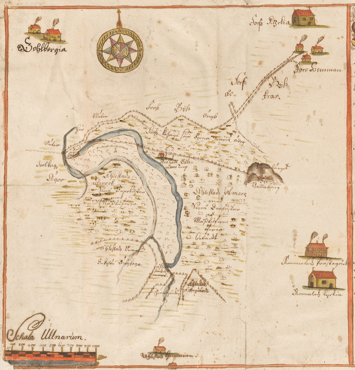
Figure 3
The ‘Lund map’ of the 1703 Skrehall landslide, by an anonymous surveyor. Source: Lund University Library. Retrieved from http://urn.kb.se/resolve?urn=urn:nbn:se:alvin:portal:record-97927. Accessed 3 May 2023.
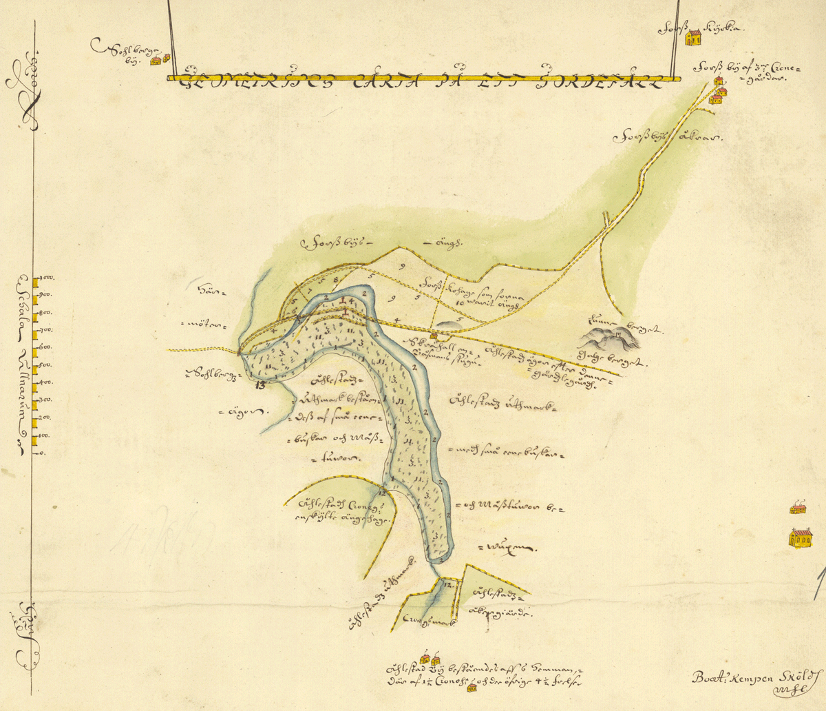
Figure 4
The ‘Arninge map’ of the 1703 Skrehall landslide, by Bo Samuelsson Kempensköld. Source: Lantmäteriet. Retrieved from https://historiskakartor.lantmateriet.se/historiskakartor/advancedsearch.html. Accessed 3 May 2023.
The maps jointly describe and depict several features within this disasterscape (Figure 1). First is the original ravine containing the small creek, which the surveyor described has having eroded the slopes to its east, causing instability and eventually collapse. Riverine erosion and unstable clay slopes would indeed not be unreasonable causes of a landslide, among other possible factors. The subsequent slump caused an extensive rift to appear, measuring 60 ells (c. 36 m) across, which equates to the modern-day scarp and depression immediately below (Figure 2). The land which had come undone and fallen into the ravine was measured by the surveyor as 2,110 ells (c. 1,253 m) long and 270 ells (c. 160 m) wide, an area measuring in total 569,700 square ells (199,395 m2), i.e., just under 20 hectares, a vast swathe of land.
This land had previously consisted of dry meadows and pastures, where juniper bushes and tufts of moss grew along with more valuable fodder; now, it was estimated to be wholly ‘ruined’ (as described by the surveyor), as stratigraphies shifted and clay soils were laid bare. The slump and subsequent blockage of the creek below had also caused extensive flooding of agricultural land, further filling up the rift or depression with water and forming small barrier lakes in other hollows further upstream to the south. Kempensköld (1703) took great care to survey exactly how large these losses had been for the locals, going farm by farm in his account. The numbers are grim.
Among the farms in the hamlet Fors, Andersgård had according to Kempensköld (1703) lost 19,000 square ells (6,650 m2) of meadow and 7,000 square ells (2,450 m2) of cattle pasture, Rättaregården had lost 14,000 square ells (4,900 m2) of meadow and 28,000 square ells (9,800 m2) of cattle pasture, and Stommen had lost a further 14,000 square ells (4,900 m2) of meadow. Fors’ lost pastures were noted by Kempensköld to have been meadows until about 15 years past, when they were given over to the cows to graze instead of being harvested for hay (due to their many junipers and moss tufts). The farmers in the hamlet Ålstad had predominantly suffered through extensive damage to their mutually managed grazelands, in total 554,000 square ells (193,900 m2) of cattle pasture, covering most of the landslide zone itself. In addition, 14,000 square ells (4,900 m2) of Ålstad meadowland had been flooded upstream. Finally, the farmers in the hamlet Solberga had lost 4,650 square ells (1,627.5 m2) of meadow (Kempensköld, 1703). In total, nearly 23 hectares of productive land had been impacted, either permanently or temporarily.
Added to this was the destruction of wooden cattle fencing, a valuable resource in an age of deforestation, and crucially also a stretch of the country road (Sw. landsväg), which passed along the parish boundary right through the landslide zone. Some 520 ells (c. 309 m) of the road were recorded by Kempensköld (1703) as being destroyed. Not only that; sections of it had been moved 60 ells (c. 36 m) out of its original location, as the unstable soil shifted beneath its own weight. The surveyor even pointed out the former and current position of the local mile pole, the wooden marker which informed travellers of the distance to the next inn and waystation. The maps depict both the former extent of the road and its new position following the landslide, along with its subsequent replacement, built by the local farmers in the wake of the disaster (Anonymous, 1703a; Kempensköld, 1703).
This was an important piece of infrastructure, namely the main land route between the towns of Gothenburg in the south and Vänersborg in the north. In wartime, especially prior to 1658 when the western side of the Göta was Dano-Norwegian territory, the river could be cut off by enemy forces and the land route was in such case the only option for commerce and troop movements. To the west of the landslide-impacted stretch of road laid the canal locks at Lilla Edet, a key site along the Göta River, and to the east the river crossing of Fors, the only place to pass over the deep Slumpån. Both places held roadside inns for the weary traveller, to which the moved mile pole would have pointed. It is difficult to date the road, but it is possibly medieval in origin (c.f. Beckman, 1923); certainly, the route existed by the 16th century at the latest (c.f. Mannerfelt, 1938, 1942).
Although Kempensköld’s (1703) map was archivally filed under the hamlet Ålstad, those closest to the event were not the nearby farmers, but rather the inhabitants of the seaman’s croft Skrehall, part of the military allotment system and located only c. 150 m north–east of the scarp. Although it may be tempting to see the Swedish word skred (today the modern word for ‘landslide’ but more complex in the past; compare the English ‘scree’) in this place name, Skrehall predates the 1703 landslide as it is shown and named on the maps of the disaster. The same toponym is found in other areas across Western Sweden; this has been interpreted by place name researchers as referring to a slanting or slippery cliff or hillock – and the croft was indeed located right by two small but notable rocky outcrops (c.f. Lundahl, 1964: 28) As the 1703 landslide is previously unrecorded in the geological inventories and has gone unnamed, I have opted to use the name Skrehall to designate the overall landslide itself, due to its proximity.
Beyond the two maps, it has proven impossible to locate further written documentary evidence from the event or the people involved. Several different archives have been consulted as part of this, including contemporary newspapers, the parish church books, regional court records, and local cultural heritage literature. Records of local taxation do exist, but they have proven too sparse to provide any meaningful data at present, as have the local church records, which provide only the sparsest details on hamlet households. To better understand the 1703 landslide, the physical landscape must be consulted.
The 2021 Fieldwork
What then remains of this disaster, other than the scarp and nearby depression, the nature of which can only be easily recognised as such through the historical maps? As mentioned, when looking at the satellite imagery, two suspiciously symmetrical and rectangular formations that appeared to roughly align with the road destroyed by the 1703 landslide can be seen, one on either side of the creek ravine. Could these earthworks be the material remains of a long-forgotten Early Modern road?
Fieldwork was carried out by the author on 8 May 2021 to determine this, with assistance from two skilled Gothenburg University student volunteers, Paula Molander and Markus Nyhlén. The weather conditions were sunny but windy, having been immediately preceded by substantial rainfall, and the physical excavations were brief but enlightening. A choice was made to keep this aspect of the fieldwork to a bare minimum, carried out to assess whether the geomorphological features seen in the satellite imagery represented coherent archaeological remains, with the goal of preserving the potential cultural heritage site from unnecessary damage by excavation. Another limiting factor was in terms of access; the site is divided between two landowners, and only one of them could be reached at the time to give permission for excavation. Therefore, efforts were focussed on the eastern side of the ravine, towards the landslide scarp (Figure 1).
As suspected based on the satellite imagery, the two earthwork features, measuring c. 70 × 15 m in the east and c. 60 × 15 m in the west, respectively, were found in both cases to consist of a central raised bank sided by two parallel ditch-like depressions, all overgrown by tufts of grass and moss (Figure 5). A 0.5 × 0.5 m test pit was hand-dug by shovel and trowel in the centre of the apparent eastern road bank (henceforth Unit A; see Figure 6) and one 1.3 × 0.3 m section was further hand-dug the same way through the apparent ditch some 40 m to the east (henceforth Unit B). The stratigraphy of Unit A, which was dug to a depth of 0.9 m, revealed little internal structure, other than a layer of dark humous soil immediately below the topsoil, followed by a thick layer of heavily compacted yellow-grey silty sand, which likely continued well below the maximum depth of the pit. In the case of Unit B, digging was aborted at a depth of only 0.5 m as it had fulfilled its purpose. While no water was seen in Unit A, Unit B quickly filled in with ample water. Three centuries after its disuse, without any management other than by grazing animals, the roadside drainage ditches still appear to fulfil their primary function. The old country road, which the two features were indeed determined to be following this fieldwork, remained dry.
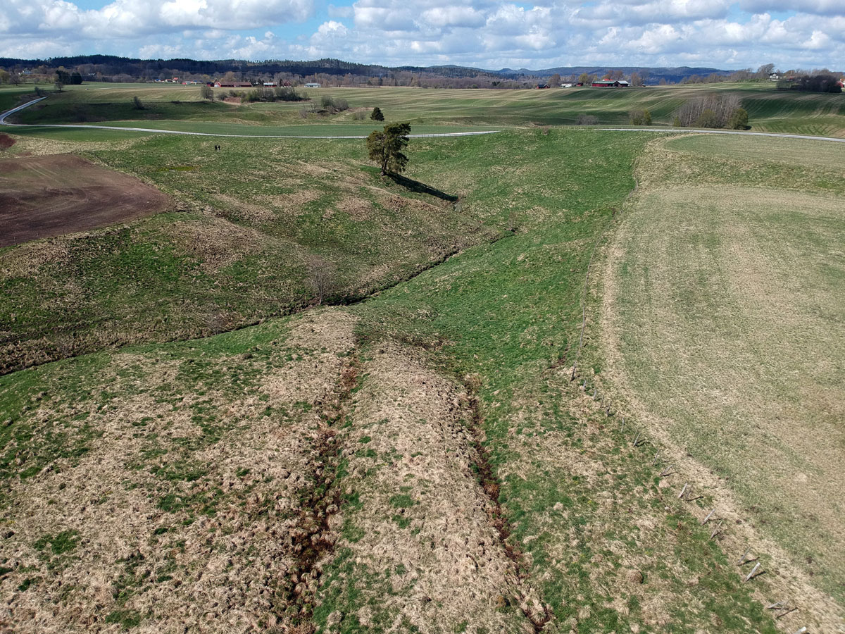
Figure 5
Drone photograph of the creek ravine, showing the eastern road section (foreground), the western road section (upper left), and the landslide scarp (upper right). Photo: Paula Molander (2021).
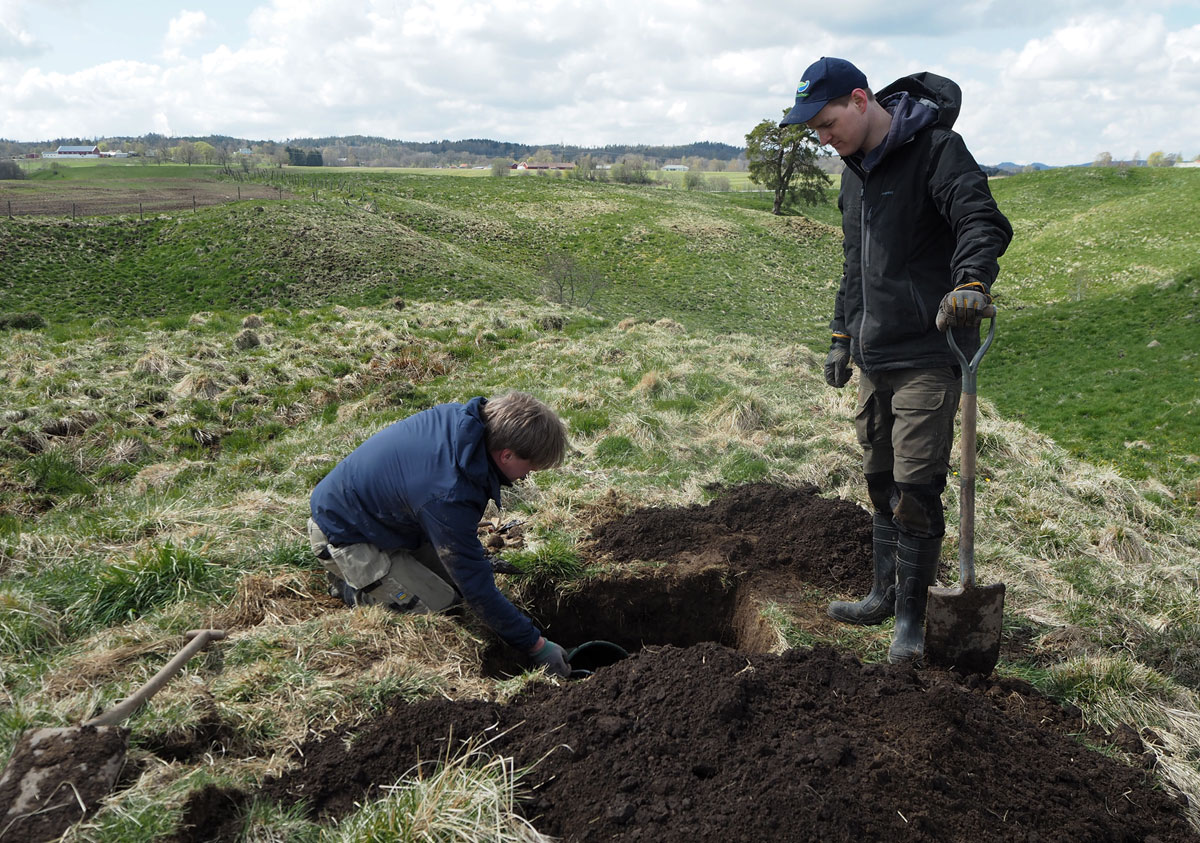
Figure 6
Snapshot from the May 2021 fieldwork, showing the process of excavating the test pit Unit A by shovel and trowel. Photo: Paula Molander (2021).
In addition to this limited excavation, the wider site was surveyed both by foot and by drone (piloted by Paula Molander), which was the main goal of the fieldwork. One point of interest was found to be that the sides of the steep ravine were completely devoid of visible stones or boulders, except at one specific point where the western road section appears to have partially collapsed. The area below the collapsed section going down into the ravine towards the creek is reminiscent of a stone scree and contains a collection of numerous large rocks (between 0.3–0.7 m in size)—which seem to have fallen out of the lower part of the road section—particularly one cluster that possibly forms a coherent structure immediately below it. The scree-like feature is likely part of a stone foundation layer of the road, placed underneath the heavily compacted soil noted in the test pit Unit A, possibly in order to stabilise the dirt road in a particularly sensitive part of the route as it entered the ravine and travellers prepared to ford the creek below. Excavation of this road section was, as noted above, not possible at the time. It was further noted that another two possible road sections were present; a central one which appears to be almost entirely collapsed on the edge of the ravine, and one further to the west of the landslide zone, close to the modern road and made almost invisible by modern agricultural erosion.
The Day of Disaster
Unfortunately, due to the brevity of records at the time, it has not been possible within this study to identify the names of the royal seaman or his family living at the croft Skrehall in 1703; neither local nor national military records have been able to provide clarity on this. Whoever they were, the landslide would have been a vivid experience for anyone living so close to the scarp. A little something can still be said about the day of disaster. As recorded by Kempensköld (1703), the landslide occurred around 8 o’clock in the evening on 15 September 1703. As Sweden followed the short-lived ‘Swedish Calendar’ at the time, this equates to 25 September 1703 in the Gregorian style. It was a Tuesday (Krook, 1702).
Autumn had begun. According to the 1662 Swedish translation of the Old Farmer’s Almanac, a common guide to agrarian life, September was a good time for drinking fresh goat milk and apple juice, gathering herbs and fruits, cutting hair, holding weddings, and sowing and planting for the next year (Arosiandrinus, 1662: 97). The Rommele and Fors parishioners were likely occupying themselves with similar things after the busy summer harvests. The last winter, 1702–1703, had been unusually harsh in the area (Hollman, 1938: 252), and it is easy to imagine that many farmers worried about what was to come once the autumn season again drew to its close.
A few hours prior to the disaster, the burial of the unnamed child of a local farmer, Per Jonsson, had taken place in Rommele Church little over a kilometre away from the landslide site (Anonymous, 1703b). The church, overseen by the recently arrived Baltic German war veteran and vicar Joachim Fredrik Kreitlow, was in a state of heavy disrepair and was torn down four years later, once the clergyman had managed to raise funds for it (Hollman, 1938: 253). Kreitlow, who oversaw both the parishes of Fors and Rommele, had already started large renovations at the vicarage that were just about to finish by the autumn of 1703 (Hollman, 1938: 253). While both the Arninge and Lund maps illustrate some neighbouring landmarks, the latter does so in detail, providing an image of the freshly remodelled vicarage as well as the possibly only extant image of the old Rommele Church before its demolition in 1707, although its accuracy could be argued. It also depicts the local gallows on a hill overlooking the passing road, a grim reminder of Carolean state authority (Anonymous, 1703a). Maybe some of the Ålstad farmers had attended their young neighbour’s funeral in that dilapidated temple earlier in the day, passing by the comparatively luxurious vicarage in the process, before finding their meadows and pastures destroyed or inundated with floodwater in the evening.
The deforested flatlands, stony hillocks and hummocky ravines were ‘theirs’ in the loosest sense of the word; they were tenant farmers, not landowners. Baron Christer Bonde the Younger owned virtually the entire area—although part of Ålstad had been pawned off just a year prior to yet another faraway magnate, the Gothenburg-based merchant Christoffer Lidberg (Hollman, 1939: 243). Both absentee landlords loomed large over the farmers. Annual fees had to be paid, often in the form of manual labour.
The psychological impact of the 1703 event can only be speculated on. Landslide events in this period appear anecdotally to have often been seen as acts of God, functioning as both divine punishment and heavenly portent. Such was certainly the case with the nearby 1648 Intagan landslide, which was at first explained as having been caused by the sins of the decadent locals, but also later used by Swedish nationalists as a positive harbinger of the area’s impending conquest from Denmark-Norway a decade later. Eyewitness accounts of this more lethal disaster (Järnefors, 1957) describe panic and prayer, dread and despair, much akin to the evocative disasterscapes observed by Kapur (2010) in India.
Even a smaller event can evoke similar emotions, when familiar and well-established agrarian landscapes become unrecognizable and uncontrollable. The Skrehall landslide shares much in terms of scale and milieu with the likewise non-lethal Västerhed landslide (roughly 22,000 m2 in size), which occurred during the night between 3 and 4 December 1785 on the lands of the manor Kvibergsnäs just outside Gothenburg. A newspaper account of this event ended as follows: ‘The scene otherwise appears like a devastated and torched village. God be praised! that neither man nor creature was hurt. May the Lord avert all such disasters from our town and country’ (Anonymous, 1786: 2, author’s translation). Based on this and other comments, the great spatial alterations to the once-familiar terrain, now torn and distorted, seem to have been particularly impactful on the observer. The 1785 Västerhed landslide impacted a tilled field and wooden fencing, but not the extensive swathes of meadow and road infrastructure of the 1703 Skrehall event.
The vicar Kreitlow would likely have advised his parishioners to have trust in divine providence and the Lord’s will, as this is a common theme in response to hardship found in preserved sermons of his dating to the period 1704–1710 (Asplund, 2017; Hollman, 1938: 247–261). Adding to the religious imagery was the acoustic and olfactory experience of a landslide. Although we have no such descriptions from Skrehall, the 1648 Intagan landslide eyewitness accounts describe crashes resembling mortar fire or lightning strikes (the sound of the ground itself breaking apart) and a great stench of sulfur (caused by chemical compounds in disturbed soil layers), all evocative of hell itself (Järnefors, 1957).
The Skrehall Disasterscape
The tangible aspects of the disasterscape are somewhat clearer. The 15 September 1703 landslide occurred as preparations were being made for the long winter season and would certainly have impacted the farmers in several ways, both immediately and in the long-term. The event represented a loss of valuable pastures and meadows, which would have helped sustain the livestock through the cold months of future years. It is difficult to calculate this loss in economic terms as it is unclear how much fodder the pastures and meadows provided, but it was likely a substantial amount. Kempensköld only recorded two partial figures for this. According to his survey, the flooded meadows of Ålstad and Solberga (which amounted to only a fraction of the total damaged productive land, and only 21% and 7%, respectively, of the total impacted meadowland) had annually produced 1.5 and 0.75 parm, an archaic measurement of hay fodder, respectively. For comparison, according to the calculations of one researcher, in Flundre Hundred around the year 1690 1.3 parm was enough to provide for one cow (Andersson Palm, 2012: 172). For tenant farmers, in the wake of a harsh winter and in wartime, every piece of cattle they could raise likely held significance.
The disaster would also have forced the farmers to divert their attention and resources from other seasonal activities to instead mend and replace the wooden cattle fencing. This could have proved costly. When the 1806 Utby landslide in nearby Hjärtum Parish damaged the same type of enclosures the surveyor counted the lost wooden fence posts by the hundreds; the value per fathom was put at 2 shillings each because the locals had access to their own woodlands (Gyzander, 1807), a luxury not everyone had. For comparison, in 1759 when surveyors came to the area to facilitate an upcoming land reform, the Ålstad farmers expressed great concern that the new boundaries created by it would lead to the decimation of their oak trees, due to the number of fence posts required (Rango, 1759). Perhaps even more so, the relocation of the country road would also have required resources and extensive manual labour, in addition to permanently removing a section of meadow from use by the Fors farmers, as recorded by Kempensköld (1703). The post-landslide road now runs due north–west of the scarp and has done so since 1703.
In imagining the disasterscape, we must also attempt to imagine not only the moment of the event and its immediate aftermath, but also the long-term processes involved which eventually led to the gradual dissolution of the disasterscape and a near-complete loss of cultural memories surrounding the original event. One aspect of this is the soil itself and its shifting nature. A landslide is not only a temporary end to terra firma, it may also cause long-term instability, recent examples of which are plentiful from Western Sweden. After the Lökeberg landslide, which occurred on 13 November 2019 west of Kungälv, the Västra Götaland County Administration cordoned off the site and closed the road leading to it due to the high risk of further mass movement causing damage or injury (Karlsson & Kruse, 2019). At least one such large collapse did occur within the zone in the week after the event (Varas Hernandez, 2019), and the ban on accessing the site was not lifted until 23 December 2020 (Länsstyrelsen Västra Götaland, 2020), over a year later. In the case of the earlier Fröland landslide, which occurred near Uddevalla on 5 June 1973 and involved extensive soil liquefaction, geologists reported minor collapses occurring frequently along the landslide scarp almost a decade after the event (Bjurström, 1982).
The affected soils around Skrehall may therefore have remained unstable for quite some time after the 1703 landslide. It can be easily imagined that locals may have been hesitant to trust the very ground beneath their feet not to shift and fall anew. That sections of the site remained prone to landslides well over a century on is shown by later maps; at least one minor such mass movement occurred in the period 1803–1817 (Beckeman, 1803; Lund, 1817). In more practical terms, factors such as these could have hindered or slowed down land reclamation through livestock grazing and the reconstruction of fenced enclosures for some time after 15 September 1703. In the end, though, the entirety of the zone was indeed ‘recolonised and utilised afresh’ as per Torrence and Grattan (2002: 9). The later maps also show that the lower plateau beneath the scarp, the very heart of the landslide, had become ploughed and sown farmland sometime in the same 1803–1817 period (Beckeman, 1803; Lund, 1817), a far cry from its tumultuous past.
The ecological processes involved in this, just like the geological processes involved in the landslide itself, did not occur overnight. Here, too, we can find parallels in the region. Olsson (1961) studied the post-disaster vegetational development of a series of landslide sites dating from the early- to mid-twentieth century, namely the 1911 Smedberg, 1946 Sköttorp, 1950 Surte and 1957 Göta landslides. He found that each of these sites, all located in environs which are quite comparable to Skrehall (in terms of ecological biome, soil types, and historical land use), showed similar successions of pioneer species taking over the mineral-rich but barren clay soils exposed by the landslides, described as follows:
… The vegetation initially appearing on landslide surfaces is predominantly composed of annuals, mainly Matricaria [wild chamomile]. After a few years this vegetation is replaced by a vegetation of perennial herbs, forming dense communities of few species predominantly Tussilago farfara [coltsfoot] and Equisetum arvense [field horsetail]. After some fifteen years these communities too begin to disappear and are replaced by gramineous species [grasses, mainly creeping bentgrass, common reed, and tufted hairgrass]. Whilst this succession is taking place in the field layer, a shrub layer has generally developed. Its pioneers are for the most part Salices [sallows], but also birch (Betula verrucosa), aspen (Populus tremula), alder (Alnus glutinosa), spruce (Picea abies) etc. may occur. … (Olsson, 1961: 127, with English names annotated by the author where these were not originally noted alongside the Latin names)
This succession of pioneer species, with annual and perennial herbs dominating for many years until grasses are more fully reintroduced, alongside the growth of shrub-like sallows, eventually replaced by evergreens and deciduous trees (Olsson, 1961: 110), took years if not decades to develop when left alone by agriculture. Many of the herbs noted by Olsson (1961: 112), especially some of the dominant ones such as wild chamomile (Sw. kamomill), coltsfoot (Sw. hästfot) and field horsetail (Sw. åkerfräken), have a traditional role in Scandinavian ethnobotany or even as famine food (c.f. Arvidsson, 2007:21; Molander, 2012: 299; Svanberg, 1997). However, the possible utility of such a herblore resource is difficult to compare to the loss of long-developed meadows harvested by scythe and rich in biological diversity or even meagre and mossy cattle pastures. Still, ‘for those living in landslide-prone regions, there are many ways to co-exist with and even benefit from landslides’, as argued by Walker and Shiels (2012: 187). Examples of local communities foraging medicinal plants and firewood growing on landslide sites are known from Central America and South Asia (Walker & Shiels, 2012: 187), and are worth considering.
It would likely take many years of managed grazing and care to restore land impacted by such events. In some cases, it took even longer; some of the meadows flooded by the 1703 landslide were still shown as barrier lakes on maps well over a century later. Although drained by agriculture today, these remained flooded as late as at least 1833. The same goes for the scarpside depression; part of it was still a landslide-formed wetland until the same period (Enander, 1833; Enander, 1839). Although these bodies of water eventually dried out and the creek down in the ravine eventually resumed its meandering ways, it took time for the scars to fade, and some yet remain.
Conclusions
It appears clear that the more well-defined features discovered as part of this study equate to ancient remains under the regulations of the 2014 Historic Environment Act (Riksantikvarieämbetet, 2019). Hopefully they can be managed and protected as such in the future. More in-depth excavation of the site, by machine rather than by hand, could likely reveal interesting facets of Early Modern roadbuilding, and the geological processes involved remain largely unexplored. In addition to this purely scholarly interest, the ruined road also highlights the Skrehall landslide’s identity as not just a geological site, but a cultural one, too; a piece of dark geocultural heritage (Scarlett & Riede, 2019).
In addition to revealing the material features and conditions of the site, the 2021 fieldwork also provided its participants with a phenomenological experience of sorts. The dramatic nature of the scarp and the ravine below, although now smoothed out by three centuries of farming, is far more apparent in person than from any map or satellite image; one can only imagine how it appeared in the moment. It was also a very special thing to walk the distorted pieces of ancient road, which neither people, horses nor oxen have used for its original purpose since 15 September 1703. The scarp and other geomorphological features, alongside the two segments of roadway, together form part of a relict disasterscape, which no doubt had a destructive, if fleeting, impact on those living near the original event.
The 15 September 1703 Skrehall landslide caused long-lasting alterations to the space in which it occurred and likely had a significant impact on the affected communities of Ålstad, Fors and Solberga. Despite this, the landslide seems to have left no permanent traces in local memory or toponymy. Further, the geomorphological traces of the event have faded similarly over time as the disaster zone was put to the plough, leaving behind a faint scarp and barely visible hollows. It has instead fallen to historical archaeology to rediscover and reimagine the disasterscape which formed at around eight o’clock one autumn evening over three centuries ago. A similar methodology—combining historical sources and archaeological fieldwork—may well have great utility at other sites of Early Modern landslides in Western Sweden, which usually have been studied solely from a geological point of view with only a passing eye to their impact on local rural communities. Care should also be taken to ensure that fragments of those communities hidden among the debris of the disasters, such as the remains of the road at Skrehall, are properly documented and preserved.
Looking outward, the concept of the disasterscape may well hold potential in other regions and periods as well, helping to highlight the significance of ancient disasters which otherwise might be dismissed or forgotten. As we live in an age in which we face hazards and disasters of varying types at an increasing frequency, we would do well to improve our understanding of such experiences in the past as well.
Acknowledgements
I would like to express my gratitude towards Joakim Olsson and his family for allowing us permission to carry out fieldwork on their land, as well as to the two anonymous reviewers who have helped improve this paper. Thanks also to Paula Molander (Gothenburg University) for her help with a myriad of things, to Markus Nyhlén (Gothenburg University) for his kind assistance with the fieldwork, and finally to Oscar Jacobsson, Lars-Ove Westerberg and Mats Burström (all Stockholm University) for their sage advice.
Competing Interests
The author has no competing interests to declare.