
Figure 1
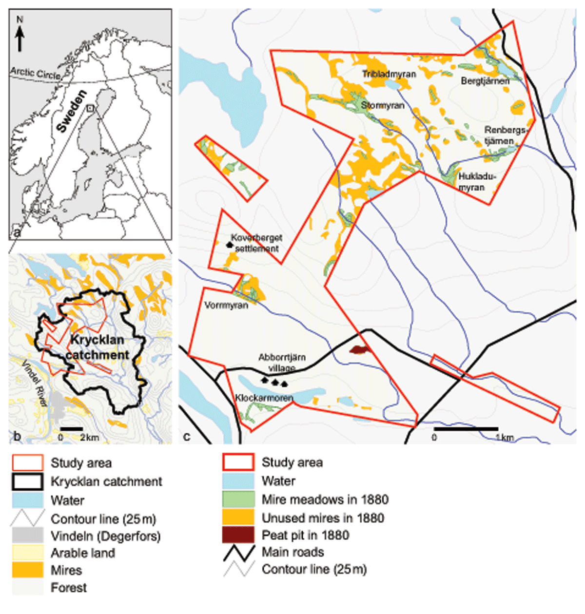
Study area. The area is located in northern Sweden (a), within the Krycklan Catchment (b). It corresponds to the village territory of Abborrtjärn as it was defined in 1880 (c). Included in map c are the polygons digitized by us for the study, i.e., mire meadows, a peat pit and unused mires marked on the map from 1880, the sum of which we have defined as the total mire area.
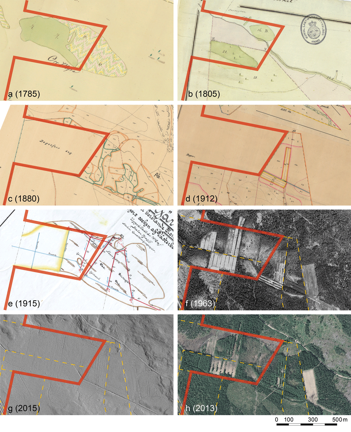
Figure 2
Some of the sources. A collection of maps and remote-sensing images used in the study. All images show the same area, Vorrmyran (Figure 1). The red line is the outer limit of the study area, which lies east of the line. a) Delineation map of Degerfors village (1785). The western part of Vorrmyran was then used as a meadow by farmers from Degerfors (green area). The multicolor part labeled with the number ‘6’ was unused mire. b) Taxation map of Abborrtjärn village (1805). The meadows marked on Vorrmyran on this map do not comply with the ones marked on other maps. According to our interpretation, the mire meadows marked here were located outside the study area. c) Enclosure map of Abborrtjärn (1880). The part already claimed by farmers from Degerfors was not included in Abborrtjärn village and thus not in our study area. Areas delimited by green lines are mire meadows, those in orange lines are unused mires. d) Cadastral map for the division of a farmstead in Abborrtjärn village (1912). The map shows a large central ditch through the mire, which had probably been dug during the large state-financed project that concerned both Abborrtjärn and several other neighboring villages a couple of years earlier. Also, the irregular meadows have been changed into rectangular fields. e) Ditching plan for Vorrmyran (1915). All ditches were created according to the plan, and at some point connecting ditches were added along the narrow fields that were created. f) Aerial photo from 1963, showing both arable land still in use and fields that have been abandoned and where brush and forest is growing back. Current property boundaries have been added as orange dashed lines to this and the following two images. g) Digital terrain model (DTM) with a 0.5 × 0.5 m grid, derived from a LiDAR flight from 2015. All ditches are clearly visible. h) Aerial photo from 2013, showing the continued overgrowth of abandoned fields, and the only field still in use (in the far right of the photo). © Lantmäteriet.
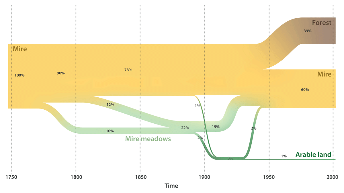
Figure 3
Mire use through time. The figure shows the development in Abborrtjärn village, Västerbotten County, from the late 1700s onwards. Until the late 1800s, haymaking concerned 22% of the mire area after which a portion of both mire meadows and unused mires were reclaimed as arable land, corresponding to 3% of the original total mire area. All of the mire meadows and most of the arable land were then abandoned and reverted to mires. Only 1% of the total mire area is cultivated today. In the 1940s and ’50s, mires were ditched to increase wood production, and about 39% of the total mire area is currently forested. The ‘60%’ number of the current mire area includes 1% of open water surface. Illustration: J. Lokrantz/Azote.
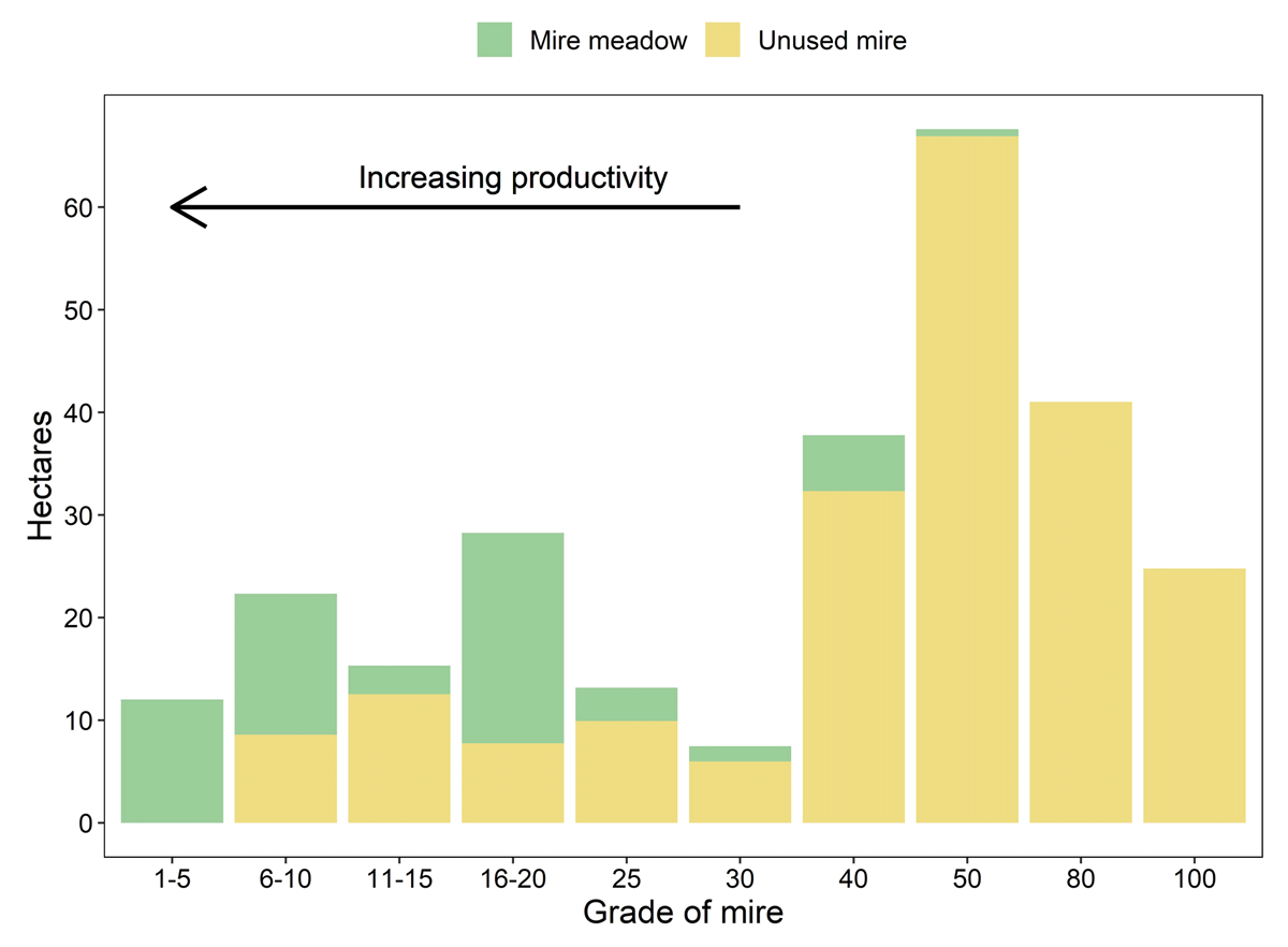
Figure 4
Area of mires of different productivity. In the enclosure documentation from 1880, all mire meadow and unused mire were graded according to productivity. Grade 1 was assigned to the most highly valued meadows, whereas higher grades represented relatively less productive meadows. Because the better (i.e., lower) grades are more detailed than the less productive (i.e., higher) grades, the former have been summed into classes.
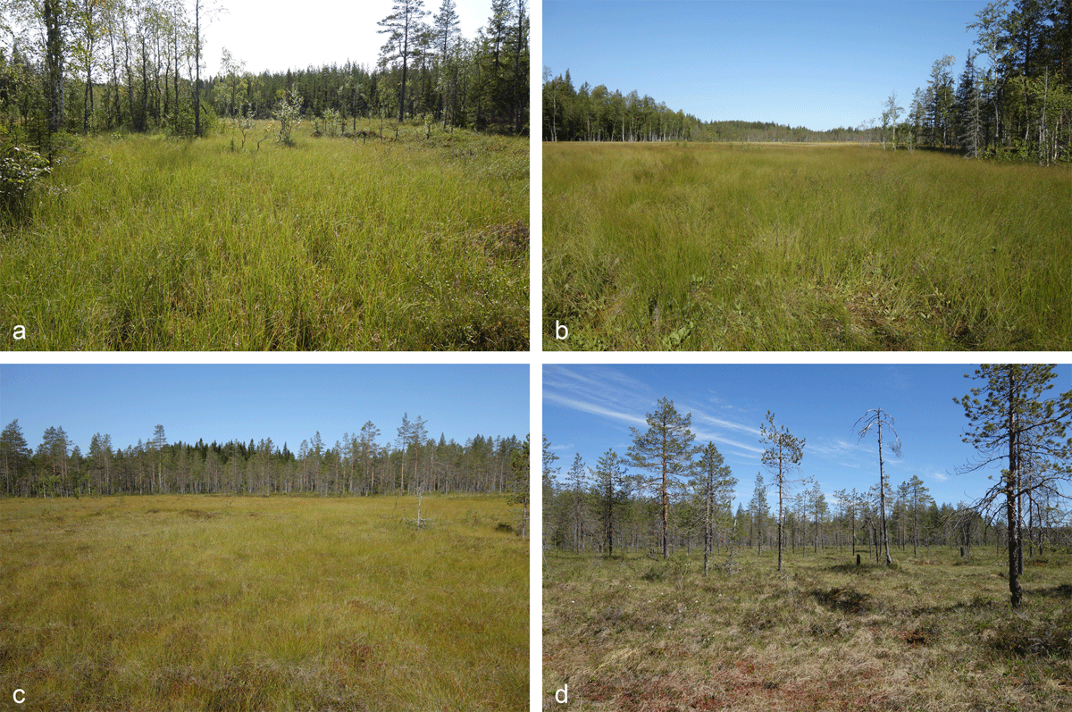
Figure 5
Different mires types in the study area. See Figure 1 for locations. a) Former mire meadow of grade 4, i.e., among the very best (Hukladumyran). The ground vegetation is currently mostly dominated by Carex rostrata together with C. magellanica and C. pauciflora, as well as Eriophorum angustifolium, Comarum palustre, and Menyanthes trifoliata in wetter parts. The surface is slowly being colonized by Betula and Salix. Carex rostrata and Menyanthes trifoliata were among the most highly valued fodder species, and Eriophorum angustifolium was also considered to be good (Frödin, 1952). b) Former mire meadow of grade 16, the most common grade but on the less productive side of the median (Stormyran). The mire is dominated by Carex lasiocarpa with some Molinia caerulea and Trichophorum alpinum. In wetter parts, Menyanthes trifoliata is found. Small bushes of Betula and Salix are growing into the mire. Carex lasiocarpa and Trichophorum alpinum were among the most highly valued fodder species, and Molinia caerulea was considered to be fairly good (Frödin, 1952). c) Former mire meadow of grade 20 (Stormyran, NW part). The vegetation is dominated by Eriophorum vaginatum and Carex pauciflora with patches of Carex rostrata. d) Unused mire of grade 50 (Tribladmyran). Calluna vulgaris is common and Cladonia lichens grow on drier tussocks. This photo was taken in June, when the vegetation was still poorly developed, whereas the other photographs are from August.
Photos: G. Norstedt.
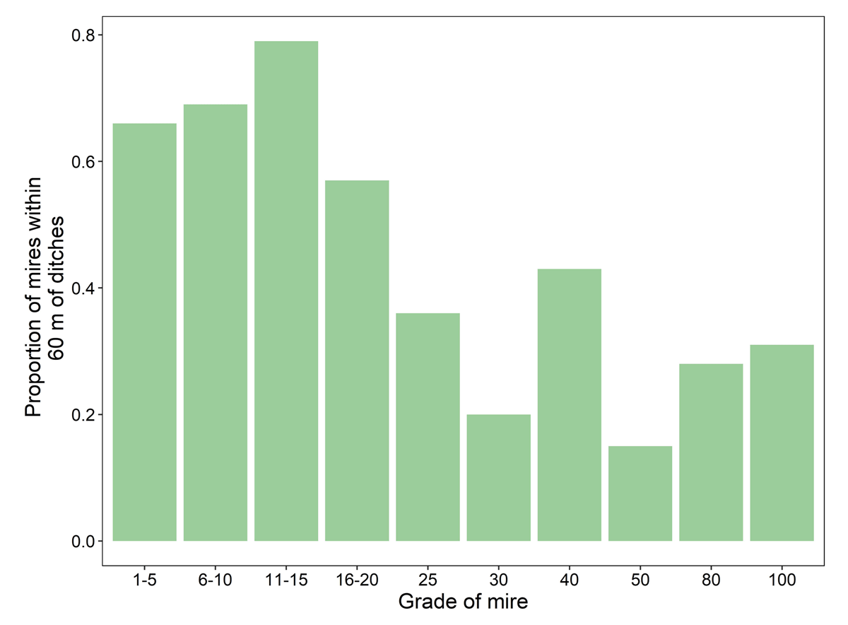
Figure 6
Mires influenced by drainage. Proportion of original mire areas (including former mire meadows, unused mires, and peat pit) of different grades that are located within 60 m from presently existing ditches.