
1 Introduction
Water resources are a daily necessity for humans, and large rivers were once the original cradle of human civilization. Today, most human settlements have been built near rivers, as humans rely on rivers to provide irrigation and residential water or to facilitate transportation and trade. Rivers played an important role in the location and layout of new settlements in historic times. For the Yellow River Delta, where river systems are constantly changing, rural settlement patterns in response to river diversion and avulsion are well worth exploring.
In prehistoric times, the survival modes of hunting, gathering and farming depended on the natural environment (Stavrianos, 2005; Wang, 2019; Wells and Postgate, 2010; Zhao, 2018). The rich natural environment along rivers and river valleys provided abundant animal and plant resources and broad living space for ancient humans (Jin, 2018; Lu et al., 2017, 2019), but the adverse effects of floods could not be ignored. For example, Ollivier et al. (2016) revealed that Holocene human settlements in the Caspian Sea region were mostly located on river tributary terraces and silty fans. This was probably linked to water supply requirements and agricultural development availability, whereas these settlements were still far enough from rivers to prevent flooding. Moreover, Shi (2013) found that Neolithic settlement sites in the Jiaodong Peninsula, Shandong Province, China, were mostly distributed in the middle and upper reaches of rivers, while they were less distributed in the alluvial plains of the lower reaches of large rivers and in intermountain basins in the middle reaches of large rivers, which reflects that the prehistoric people not only needed rivers as a source of water for living but also actively avoided the harm caused by floods and debris flows. The human occupation pattern of the Danube Delta at the same time has also been shown to be heavily determined by flooding (Bonsall et al., 2015; Carozza et al., 2012).
Since then, humans have increasingly adapted and improved their ability to use natural resources. The construction of irrigation channels, dams and other water conservancy facilities has enabled people to better utilize the resources brought by rivers and to reduce the harm of river avulsion and flooding (Stavrianos, 2005; Wells and Postgate, 2010; Zhao, 2018). As a result, the proximity of settlements to water sources increased significantly, which has been confirmed by numerous archaeological studies of the world’s great river basins. The Sumerians settled on the floodplains of the Euphrates and Tigris Rivers around the 4th millennium BC, relying on irrigation facilitated by rivers and man-made canals to develop agriculture and to build some of the world’s first cities (Bagg, 2000; Ur, 2014). From the Ptolemaic period to the Roman period (4th century BC to 7th century AD), the number of settlements in the Nile Delta on highly elevated levees along channels increased (Ginau, 2018; Schiestl, 2012; Wilson, 2015). However, these high levees were not sufficient to curb the diversion of rivers and flooding, which led to the abandonment and construction of settlements (Ginau, 2018).
Historically, with the expansion of farming and the continuous development of water conservancy technology, the relationships between human production and life and water sources (especially rivers) became increasingly closer. Since ancient times, the Danube and lower Rhine Rivers have nurtured countries along their banks (Dobrescu & Grigorescu, 2011; Preoteasa et al., 2019; Mako & Galieriková, 2021; Uehlinger et al., 2009). The Mississippi River is the political, economic and shipping lifeblood of North America (Batker et al., 2010; Stearns, 2011). Between 1687 and 1702, the course changes in the Euphrates River jeopardized the stability of the eastern Ottoman Empire and left behind a profoundly altered ecological and political landscape in a rural region southwest of Baghdad (Husain, 2016). Floods and changing rivers played a highly important role in the East India Company’s control, management and trade of colonial Bengal from the late 18th century to the mid-19th century (Bhattacharya, 2022; Cederlöf, 2014). In China, the Yangtze River and the Yellow River are called the ‘mother rivers’ of the Chinese nation, with many dynasties arising and developing along their banks (Zhang, 2001). In some specific areas, such as mountainous areas, plains, karst areas, and humid and arid areas of China, settlements also show obvious distribution patterns near rivers (Ma et al., 2018; Ma et al., 2022; Wei et al., 2022; Xiang et al., 2023; Xie et al., 2013; Zeng et al., 2020).
The vast majority of studies on river-related settlement patterns have considered only established patterns but not occupation over time in relation to river dynamics. There is still a lack of research examples on the impact of river avulsion on settlements in delta areas in China with continuously changing river systems. At the same time, archaeological studies on occupation patterns along dynamic rivers mostly rely on complex environmental archaeological methods and are costly.
The Yellow River Delta offers a unique opportunity to study the development of settling patterns in response to river dynamics and avulsion. The delta has gradually expanded since 1855 when the Yellow River debouched in the sea in Shandong Province. The changes in river diversion and in avulsion and settling and changes in the number and location of settlements in this region over the last 150 years have been well documented in the form of documents and digital maps, which makes studying the Yellow River Delta relatively convenient. On the other hand, the Yellow River Delta is one of the estuarine deltas with the fastest land growth in China and even in the world. Affected by many factors, such as siltation and changes in river channels, the natural environment is experiencing constant and rapid changes (Han et al., 2006; Lu, 2019), which often creates a unique spatiotemporal pattern of settlements and alters the relationship between humans and water.
With the Yellow River Delta as the research area and based on historical river channel and historical village data from 1855 to 2000, this study aims to reveal the response of the spatial distribution of settlements in this region to the diversion and avulsion process of the Yellow River and intends to answer the following two questions: (1) What are the quantitative and spatial variation characteristics of rural settlements in the delta against the background of avulsion and settling of the Yellow River tail? (2) What is the spatial relationship between rural settlements and the old and new channels of the Yellow River, especially the inertia of rural settlement distribution to the old channels? It is hoped that this research can provide information about the characteristics of rural living settlements and human-water patterns in deltas.
2 Regional background
This study focuses on the modern Yellow River Delta area (Figure 1, Figure 2), in particular on Ninghai in the Kenli District, Shandong Province, as the focal point, starting from the Tao’er River Estuary in the north and ending at the Zhimai River Estuary in the south, bordering Bohai Bay in the north and adjacent to Laizhou Bay in the east, with a total area of approximately 5400 square kilometres.
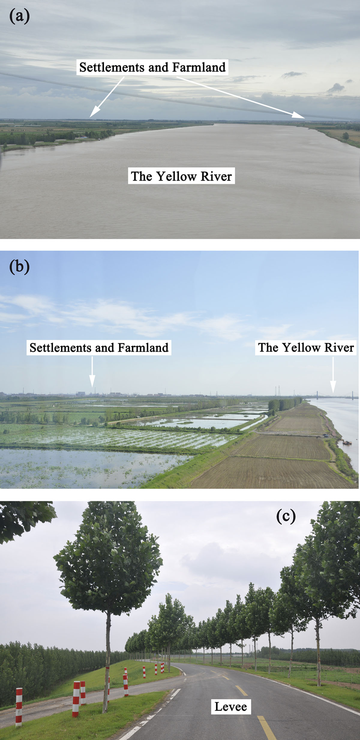
Figure 1
Settlements, farmland and a levee in the Yellow River Delta. (a) the photo taken on the pontoon bridge near Ningjia village, Kenli District, Dongying City; (b) the photo taken on the Dongying Yellow River Bridge in Kenli District, Dongying City; (c) the photo taken near the Lijin Hydrological Station, in Lijin District, Dongying City.
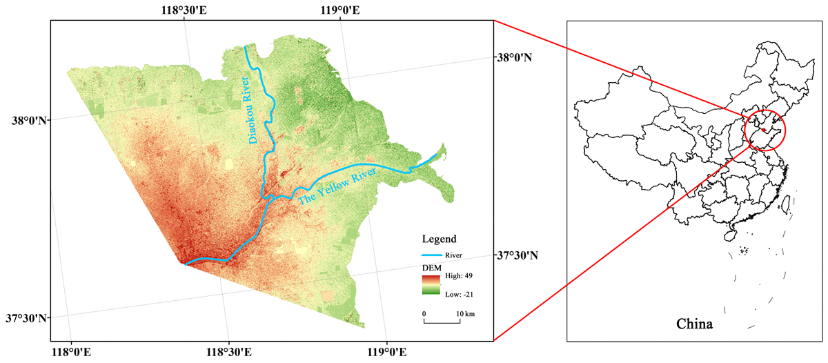
Figure 2
Yellow River Delta.
The Yellow River Delta is a typical low-elevation flat delta plain with an average elevation of 5–6 m. It comprises some microtopography features, such as hills, sloping fields, river fluvial plains, low-lying lands, and hillocks caused by dike breaching and diversion of the Yellow River (Lu, 2018). The Yellow River Delta is located in the temperate subhumid continental monsoon climate zone, with an annual average temperature between 11.7 and 12.6 °C and an annual average precipitation of 530–630 mm. The annual precipitation is uneven and concentrated from July to September. The Yellow River is the longest, most profound and most extensive river flowing through the delta. In addition, there are several secondary rivers and artificial canals for flood control, flood discharge and drainage (Administration Bureau of the Yellow River Estuary, the Yellow River Conservancy Commission, 1995). Fresh groundwater resources are scarce in this area, while brackish and brine water are widely distributed (Wang, 2012). The main types of soil are aquatic soil, saline flavo-aquic soil and alluvial-salt soil (Liu et al., 2017). The natural vegetation of the whole Yellow River Delta is mainly composed of saline meadows, with fewer woody plant species (Lu, 2019). However, many inland areas have been reclaimed for farmland and small-scale plantations.
The Yellow River has a very large sediment flux with monsoon-driven seasonal variations in river discharge and sediment load. At a decennial time scale, it has experienced regular avulsion and diversion, resulting in channel siltation, sediment rerouting and delta extension (Zou et al., 2013). Since the Yellow River diverted to the sea in Shandong Province in 1855, there have been three cycles of north–south swings in the river course of the Yellow River, forming 11 channels (except for the Freshwater Ditch Channel from 1976 to 1996 and the Diaokou River Channel from 1964 to 1976; the other channels have dried up) (Table 1). With continuous silt accumulation and the extension of delta lobes, the present-day Yellow River Delta eventually formed.
Table 1
History of the YRD distributary channels and avulsions since 1855 (Administration Bureau of the Yellow River Estuary, the Yellow River Conservancy Commission, 1995).
| NO. | AVULSION YEAR | AVULSION LOCATION | LOCATION OF CHANNEL MOUTH | CAUSE OF AVULSION | TIME INTERVAL TO THE NEXT AVULSION | ACTIVE TIME |
|---|---|---|---|---|---|---|
| 1 | June 1855 | Tongwaxiang | Xiaoshenmiao Village and Oyster Mouth | The first active river since Tongwaxiang crevasse | 33 years and 9 months | 19 years |
| 2 | March 1889 | Hanjiayuan | Maosituo | The breaching due to ice jam in winter | 8 years and 2 months | 5 years and 10 months |
| 3 | May 1897 | Beilingzi | Siwangkou | The dyke breaching due to flood | 7 years and 1 month | 5 years and 9 months |
| 4 | June 1904 | Yanwo | Lao Hu Mouth, Car Ditch, Noodle Ditch, Tao ‘er River | Crevasse caused by summer flood | 22 years | 17 years and 9 months |
| 5 | June 1926 | Balizhuang | Old Diaokou | Crevasse caused by summer flood | 3 years and 2 months | 2 years and 11 months |
| 6 | August 1929 | Jijiazhuang | Nanwang River; Siwangkou old River Course; Song Chunrong Ditch; Qingtuozi | Artificial breaking diversion | 5 years | 3 years and 4 months |
| 7 | August 1934 | No. 1 Dam in closure | Sweet Water Ditch, Fairy Ditch, Song Chunrong Ditch | Crevasse caused by summer flood | 19 years | 9 years and 2 months |
| 8 | July 1953 | Xiaokouzi | Fairy Ditch | The artificial course diversion | 10 years and 5 months | 10 years and 5 months |
| 9 | January 1964 | Luojiawuzi | Diaokou River | Artificial diversion | 12 years and 5 months | 12 years and 5 months |
| 10 | May 1976 | West river mouth | Fresh Water Ditch | Artificial diversion | 20 years and 2 months | 20 years and 2 months |
| 11 | July 1996 | Qing 8 Route | Artificial diversion | To date |
With progressive agricultural development, population growth and intensification of human-land conflicts in the Qing Dynasty, the new land in the Yellow River Delta became the first choice for reclamation and gradually transformed from an untrodden delta plain into a thriving landscape with villages and arable land. During this period, farming was the main type of livelihood for residents of the Yellow River Delta. Salt (such as high-salinity groundwater and salinized soil) and flooding (caused by the Yellow River breach) are major constraints on agricultural production in the Yellow River Delta, while the water and sand delivered by the Yellow River serve as sources of fresh water supply and natural fertility, respectively, to sustain agricultural production. Balances between salt and fresh water and between flooding and silting are the most critical factors affecting land development and village construction in the Yellow River Delta, and they even have special spatial implications.
3 Materials and methods
3.1 Data sources
3.1.1 Channel vector data of the lower Yellow River since 1855
The data for the lower Yellow River since 1855 were obtained from the 1:1,000,000 Main River Changes Database of the lower Yellow River (1855–2005) released by the National Earth System Science Data Center of China (http://www.geodata.cn), a national platform for basic conditions of science and technology. The data contain the changes in the Yellow River course in 11 periods between 1855 and 2000 (Figure 3, Table 1). The dataset was produced by the College of Environment and Planning of Henan University. The researchers consulted historical documents and combined the field archaeological results to construct a simulation map of the river course changes in the lower Yellow River from 1855 to 2000. After scanning, the map was input into the computer, and the screen tracking vectorization method was adopted to digitize the dataset. In the process of manual sorting, proofreading and input, the quality of the data was strictly controlled, and there was a special person for data sampling and proofreading. The data quality is high, and the source is real and reliable.
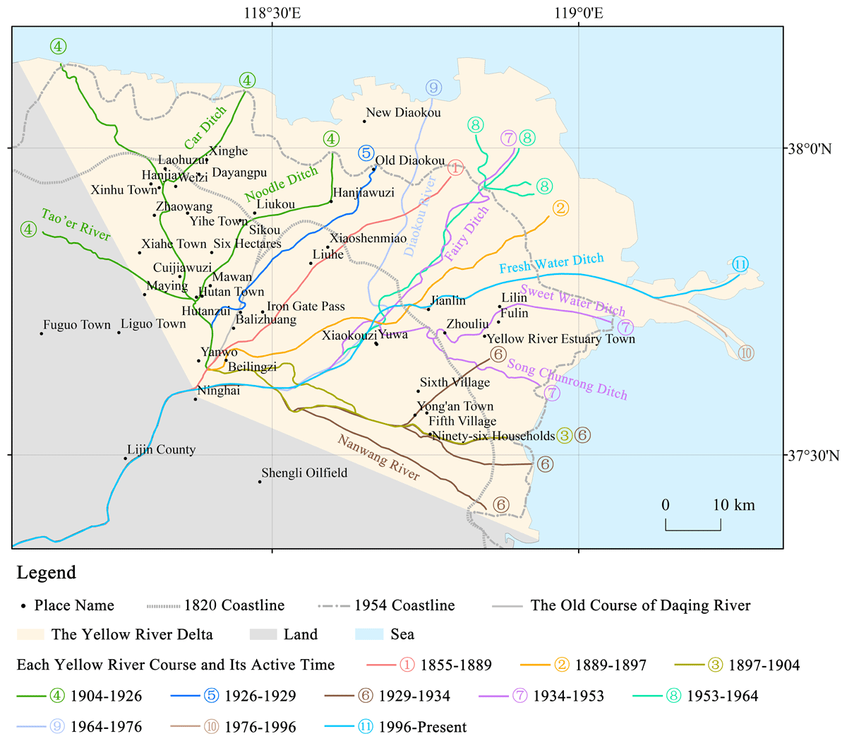
Figure 3
Course changes in the Yellow River Delta.
3.1.2 Coastline data of the Yellow River Delta
The coastline data for 1820 were obtained from the Chinese historical geographic information system (CHGIS) (https://sites.fas.harvard.edu/~chgis/), which is directly digitized based on the map of the eighth volume of the Historical Atlas of China (Tan, 1982). For 1954, the coastline was obtained by the registration and vectoring of the Map of Channel Changes of the Yellow River Estuary Delta since 1855 in the book of Chinese Historical Physical Geography (Zou et al., 2013). Modern coastline data were extracted from the 1:400,000 Chinese Administrative Zoning Map of the National Center for Basic Geographic Information (https://www.webmap.cn).
3.1.3 Rural settlement data
The data sources of the place names, establishment times, and coordinates of the rural settlements in the Yellow River are shown in Table 2. Village coordinate data were extracted from the Baidu map using the coordinate system on the website (http://api.map.baidu.com/lbsapi/getpoint/index.html).
Table 2
Data sources of rural settlements in the Yellow River.
3.2 Research methods
The kernel density estimation (KDE) method was used to analyse the spatial distribution characteristics of villages in the Yellow River Delta. KDE fully reflects the law of distance attenuation in geography. The spatial change is continuous, and the ‘crest’ and ‘trough’ strengthen the spatial distribution pattern displayed. Therefore, the spatial distribution of place names can be objectively and accurately expressed (Wang, 2006).
The kernel density equation is shown in Equation (1) below. In this equation, f(x) is the normal kernel density, K( ) is the kernel density, h is a smoothing parameter (also known as the bandwidth), n is the number of points within the threshold range, and d is the dimension of the data. The density distribution is highest at the centre of each point and continuously decreases with increasing distance. The geometric meaning of the kernel density equation is that when the distance from the centre reaches a certain threshold range, the density is 0.
We regard the study area as a two-dimensional space, so in our study, d = 2; at the same time, we regard villages as point data. The normal kernel density is calculated as follows (Equation (2)):
In Equation (2), i represents a village, (xi,yi) represents the coordinates of village i in a two-dimensional coordinate system, and (x,y) represents any point within the search radius h, so (x–xi)2 + (y–yi)2 is the distance between (xi,yi) and (x,y). Here, 1 km, 3 km, and 5 km were taken as the search radii h for the operation of kernel density analysis in ArcGIS10.2, among which 5 km was the best because of its best cartographic effect, so the search radius was set to 5 km, and the value outputs of pixel size were assumed to be the default value of ArcGIS, which was approximately 2′ × 2′.
Referring to the data of place names and county records, the village establishment times of 714 villages in the Yellow River Delta region were obtained. Geographic coordinate information and ArcGIS kernel density analysis were used to generate a map of the kernel density distribution of the delta villages. From the perspective of spatial visualization, this study analysed the temporal and spatial distribution characteristics of villages and their responses to Yellow River diversions since 1855.
4 Results
4.1 Number of villages in the Yellow River Delta
The total number of villages in the Yellow River Delta is 714, of which 92 existed before 1855, and 622 were newly added after 1855.
Taking 10 years as a statistical period, the number of newly added villages in the Yellow River Delta during each period from 1855 to 2000 showed an ‘inverted V’ pattern of change, which first increased and then decreased (Figure 4). Corresponding to the number of newly added villages in each period, the total number of villages in the Yellow River Delta continued to increase and could be divided into three stages according to the growth rate:
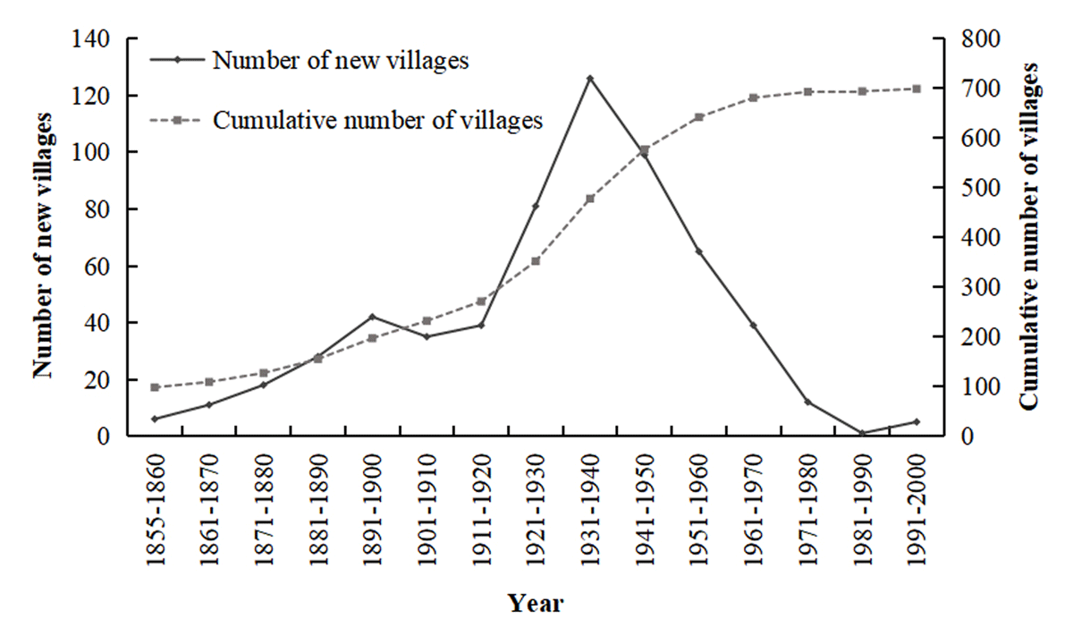
Figure 4
Changes in the number of villages in the Yellow River Delta.
① The steady growth stage of villages occurred from 1855 to 1920, with a growth rate of approximately 2.7 villages per year. In this stage, the continuous increase in population in Shandong became the key driving force for land reclamation and village establishment (Yan, 2010). This stage corresponds to the active time of the first, second, and third river courses of the Yellow River.
② During 1921–1970, the number of villages increased significantly, exceeding 10 villages per year. In 1931–1940, 126 villages were built, more than the total added villages during 1855–1900. This stage corresponds to the active time of River Courses 4, 5, 6, 7, and 8 of the Yellow River. A large area of fertile land was silted up by the frequent diversion of the tail of the Yellow River, which attracted indigenous and foreign settlers who reclaimed the land, and many villages were established as a result.
③ During 1971–2000, the growth rate of villages was only 0.6 per year. Perhaps the low growth rate was related to the influence of oil field construction and wetland protection policies; some villages declined in size, were relocated, or even disappeared.
4.2 Spatial pattern of villages in the Yellow River Delta
Before the Yellow River diverted to Shandong in 1855, the villages in the Yellow River Delta were mainly concentrated along the Daqing River (Figure 5). The high-value area of the kernel density presented a banded distribution along the Daqing River, and the kernel density decreased gradually with increasing density shifting to the sea. Moreover, a few villages were scattered in the inland area of the Yellow River Delta. With the Daqing River as the axis, two small densely populated areas of villages formed. Many villages are still established and developed in these areas.
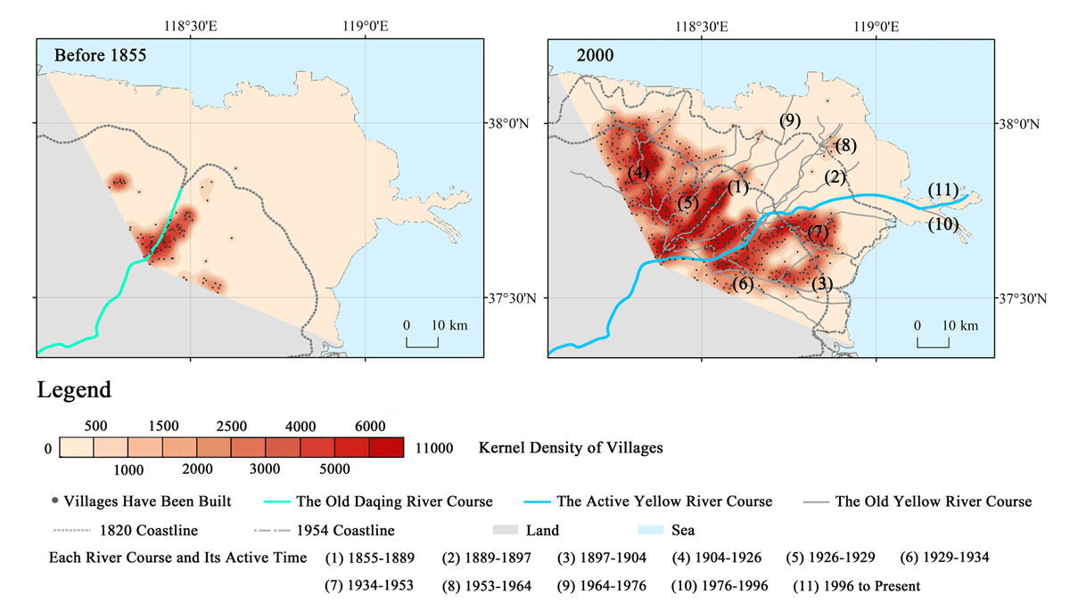
Figure 5
Spatial pattern of villages in the Yellow River Delta.
In August 1855, the Yellow River broke at Tongwaxiang in Henan Province, and then seized the Daqing River into the sea in Shandong Province. Since 1855, the distribution range of villages and the range of high nuclear density areas in the Yellow River Delta have expanded significantly, but the nuclear density is still significantly greater in inland areas than in coastal areas. Specifically, the Tiemenguan River Course (River Course 1) of the Yellow River was considered the axis; it expanded to the northeast and southeast, and it further extended to the sea. In this stage, three zones with high nuclear density appeared, and they were distributed along the Tiemenguan Channel (1855–1889), Hutanzui Channel (1904–1926), Sweet Water Ditch and Song Chunrong Ditch Channel (1934–1953). The kernel density was 2–7 times that of other areas.
4.3 Characteristics of the spatial distribution of newly added villages and their responses to each channel
To explore the spatial distribution characteristics of newly added villages in the Yellow River Delta and the response relationship between the number of newly added villages and the active time of each channel of the Yellow River, the number of newly added villages during the active time of each channel was calculated, and the spatial distribution of newly added villages was analysed via the kernel density estimation method.
The newly added villages during the active period of each course in the Yellow River Delta were concentrated along the active channel and near the silted-up abandoned channel (Table 3; Figure 6). According to the distribution characteristics of villages and their responses to the Yellow River rerouting since 1855, the avulsion and settling history could be divided into three stages.
Table 3
The number and proportion of newly added villages along the Yellow River during each flow period *.
| RIVER COURSE 1 | RIVER COURSE 2 | RIVER COURSE 3 | RIVER COURSE 4 | RIVER COURSE 5 | RIVER COURSE 6 | RIVER COURSE 7 | RIVER COURSE 8 | RIVER COURSE 9 | RIVER COURSE 10 | THE NUMBER OF NEW VILLAGES ALONG THE COURSES IN EACH PERIOD | THE TOTAL NUMBER OF NEW VILLAGES IN EACH PERIOD | ||
|---|---|---|---|---|---|---|---|---|---|---|---|---|---|
| 1855–1889 | N** | 38 | 38 | 48 | |||||||||
| P*** | 79% | 79% | |||||||||||
| 1889–1897 | N | 12 | 15 | 27 | 32 | ||||||||
| P | 37% | 47% | 84% | ||||||||||
| 1897–1904 | N | 6 | 10 | 10 | 26 | 36 | |||||||
| P | 16% | 28% | 28% | 72% | |||||||||
| 1904–1926 | N | 5 | 13 | 11 | 64 | 93 | 107 | ||||||
| P | 5% | 12% | 10% | 60% | 87% | ||||||||
| 1926–1929 | N | 1 | 0 | 3 | 9 | 0 | 13 | 17 | |||||
| P | 6% | 0% | 18% | 53% | 0% | 77% | |||||||
| 1929–1934 | N | 1 | 2 | 4 | 31 | 2 | 4 | 44 | 51 | ||||
| P | 2% | 4% | 8% | 60% | 4% | 8% | 86% | ||||||
| 1934–1953 | N | 7 | 5 | 10 | 87 | 15 | 56 | 27 | 207 | 217 | |||
| P | 3% | 2% | 5% | 40% | 7% | 26% | 12% | 95% | |||||
| 1953–1964 | N | 2 | 1 | 0 | 4 | 11 | 1 | 59 | 3 | 81 | 82 | ||
| P | 2% | 1% | 0% | 5% | 14% | 1% | 72% | 4% | 99% | ||||
| 1964–1976 | N | 3 | 1 | 0 | 4 | 2 | 1 | 6 | 1 | 0 | 18 | 18 | |
| P | 16% | 6% | 0% | 22% | 11% | 6% | 33% | 6% | 0% | 100% | |||
| 1976–1996 | N | 1 | 0 | 0 | 1 | 0 | 1 | 7 | 2 | 0 | 0 | 12 | 13 |
| P | 8% | 0% | 0% | 8% | 0% | 8% | 54% | 15% | 0% | 0% | 93% | ||
| The total number of new villages along each channel | 76 | 47 | 38 | 200 | 30 | 63 | 99 | 6 | 0 | 0 | |||
[i] * Villages within 5 km of each river course are counted as coastal villages of each old route
** The number of newly added villages along each course.
*** The proportion of newly added villages along courses to the total number of new villages in the period.
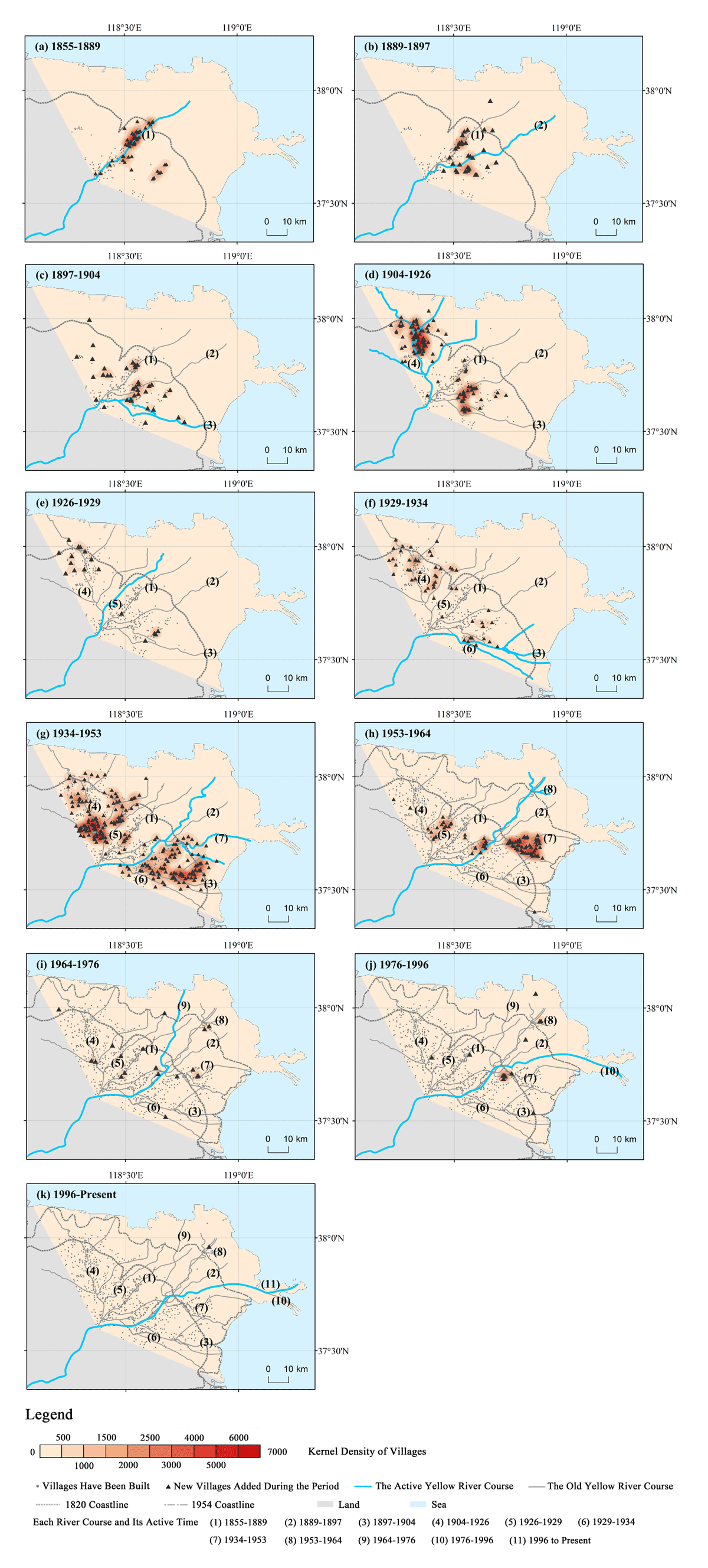
Figure 6
Density distribution of newly added villages in the Yellow River Delta during different periods after 1855.
Stage 1: From 1855 to 1926, the Yellow River experienced three avulsions caused by floods. After each avulsion, approximately 70% of the total new villages were built along the active new course and the dried-up old courses. The number of villages involved in the active course was greater than that involved in the old course.
During the period from 1855 to 1889, most new villages in the Yellow River Delta were located along the river, forming a high-density belt along River Course 1. During the active time of River Course 2 from 1889 to 1897, most of the newly added villages in the delta were distributed in a V-shaped pattern along River Course 1 and the active river channel (River Course 2) with the Hanjiayuan crevasse site as the vertex; the number of villages along the two rivers was similar. During the active time of River Course 3 from 1897 to 1904, the newly added villages were distributed in a scattered manner along the three river channels (River Courses 1, 2 and 3). During the period from 1904–1926, the number of newly added villages was greater than that in the previous three periods. Among them, more than half of the new villages developed along River Course 4, forming the core area of village distribution. The number of new villages along River Courses 2 and 3 was also large.
Stage 2: During the period from 1926–1964, the Yellow River experienced three avulsions: one developed from a crevasse caused by a summer flood, and the other two were artificial channel diversions. Different from the previous stage, after each avulsion, few village was built along the new river branch, and the new villages were mainly concentrated along the old courses that had dried up, accounting for 50–70% of the total new settlements. During this period, there was much silted land reclamation and village construction in the old channel, which was due to river diversion and the range of silted land, as well as the Yellow River flood and the official immigration policy.
The distribution of villages in this stage was more complex than that in the previous stage. From 1926 to 1953, during the active periods of River Course 5, River Course 6, and River Course 7, the number of new villages along River Course 4 was the largest, and the proportion reached approximately half. River Course 4 had ‘the benefit of silting land’ and was very attractive for reclamation. As a result, many villages were established between 1926 and 1953 along River Course 4. Similarly, during the period from 1934–1953, many villages were established on fertile land that was silted up by River Course 6. Together with those along River Course 4, these accounted for approximately two-thirds of the total number of new villages established during the active period of River Course 7. During the period from 1934–1953, two high-density areas with different levels and patterns of villages formed in the northwestern and southeastern regions of the delta. The villages around River Course 6, such as the Fifth Village, Sixth Village, and Ninety-six Households Village in Yongan Town, Kenli County, were formed during the active period of River Course 7 (1934–1953). From 1953 to 1964, during the active period of River Course 8, more new villages were significantly more common near River Course 7 than along other old routes, such as Fulin Village, Lilin Village, and Zhouliu Village in Huanghekou Town, Kenli County, which formed a dense distribution area in the triangular area surrounded by branches of Sweet Water Ditch and Song Chunrong Ditch, accounting for approximately three-quarters of the total number of new villages during the active period of River Course 8.
The different distribution characteristics of villages in stage 1 and stage 2 may be attributed to the following two factors. On the one hand, there were differences in the patterns of each channel and the extent of silted land. River Courses 1, 2, and 3 were single channels, so after abandonment, the area of the silted-up channel was relatively narrow. During the active period of River Courses 1, 2 and 3, the attraction of silted land by old river courses was not much different, and even the former was stronger. River Courses 4, 6, and 7 had at least three river branches and flowed through a wide area; ‘the benefit of silting’ was very significant. Among them, River Course 4 had the largest impact area. In its active period and the active periods of River Courses 5, 6, and 7, the proportion of newly added villages along the river was the highest. On the other hand, in the second stage, the official immigration policy stimulated the growth of the number of villages. In August 1933, the Yellow River flooded 30 counties in Henan, Shandong, Hebei, and Jiangsu Provinces. On July 10th, 1935, the Yellow River breached its banks at Dongzhuang Village, Juancheng County (located in the upper reaches of the Yellow River delta, approximately 400 km from the Yellow River delta), and western Shandong was inundated again in an ‘especially unprecedented catastrophe’ (Shandong Yellow River Flood Relief Committee, 1935). Faced with a large number of victims caused by two Yellow River floods, the government implemented a reclamation plan to migrate them to the Yellow River Delta (Zhang, 2019). At this time, the old, silted land in the Yellow River Delta, especially that of River Course 4, naturally became the best choice for resettlement, and villages continued to be established.
Stage 3: From 1964 to the present, the Yellow River has undergone two artificial diversions. After each diversion, the number of newly added villages decreased sharply compared to that in the first two stages, and they were scattered along the banks of several old river courses.
From 1964 to 1976, during the active period of River Course 9, villages were built along the Yellow River courses except for the active river course and River Course 3, and villages in River Course 7 were the most common, while villages in River Course 2, 6, and 8 were the least common. From 1976 to 1996, during the active period of River Course 10, more than half of the new villages in the delta were concentrated along River Course 7, and the rest were scattered in River Courses 1, 4, 6, and 8. Since 1996, only one new village has been added, and it is located at the old river mouth of River Course 8.
In this stage, after a long period of desalinization and dealkalization, the difference in soil quality between the old river courses of the Yellow River Delta decreased, which might be the main reason for the scattered distribution of new villages. In addition, it was influenced by the development of oil fields and wetland conservation. For example, there were oil fields and their associated factories near River Courses 8, 9, 10 and 11, which might occupy areas of living places and farmland. Therefore, new villages were not gathering along these channels. On the other hand, wetland conservation could force some coastal villages to return farmland to wetlands so that the villagers had to move to other places to make a living.
From 1855 to the present, the Yellow River breached its banks and changed its course several times. Progressive sedimentation caused the Yellow River Delta to further expand, and the area of land available for reclamation continued to increase. Additionally, benefiting from the sediment fertility of the Yellow River and the effects of salt and alkali reduction, the dried-up riverbed and surrounding silted land after the Yellow River avulsion were suitable for crop cultivation. Therefore, the constant increase in land suitability for reclamation has provided the material basis for agricultural development, attracting villagers to reclaim and settle. As a result, many villages have emerged, and their distribution pattern has shown great changes.
5 Discussion
Agriculture (especially crop farming) is the most fundamental and important economic activity in many river deltas. The location of the associated delta settlements reflects the spatial path of land reclamation, which should be a process of seeking benefits and avoiding disadvantages. The unique geographical environment of deltas is both beneficial and harmful to agricultural development and human settlement.
There are two adverse effects of natural processes on new settling patterns: flooding and soil salinization. First, the flooding of large rivers would undoubtedly destroy arable land and villages, and archaeological sites also show traces of villages being washed and drowned by floods (Ginau, 2018; He et al., 2021; Zhu, 2003). Second, because deltas are close to the sea and affected by tides, the groundwater salinity rate is high, coupled with the low and flat terrain, the soil water release ability is weak, and soil salinization is widespread, which has become the greatest limiting factor for the development of agriculture in deltas. Moreover, impractical irrigation will also cause and aggravate secondary salinization of soil (Altaweel & Watanabe, 2012; Hammam & Mohamed, 2020; Kotb et al., 2000; Shahid et al., 2018; Tamburrino, 1970; Yu J et al., 2014; Zhang et al., 2011).
There are also two benefits: easy access to water and fertile soil from floods. First, large rivers provide deltas with easy access to water for irrigation and domestic use. The role of water is especially important in the Nile Delta, Mesopotamia Plain and other arid climate areas (Bagg, 2000; Ginau, 2018; Wang, 2019). Second, flooding often causes the soil from the upper and middle reaches to silt over large areas along the coast, which is fertile and can provide nutrients for a new round of crop cultivation. For example, Egyptians were able to grow cotton in the Nile Valley as early as 4000–5000 years ago, taking advantage of the regular flooding of the Nile caused by seasonal heavy rains on the Ethiopian Plateau (Craig, 1993; Liu, 2000).
From this point of view, the influence of large rivers on deltas is not unidirectional but rather has dual effects – flooding and siltation. The Yellow River has a very high sediment content and is good at sedimentation and migration. The extremely high sediment content significantly amplifies both the beneficial and adverse effects of Yellow River flooding.
Similar to other deltas, soil salinization is a key limiting factor for reclamation in the Yellow River Delta, and the land reclamation process in the Yellow River Delta is a continuous search for low-salinization land that can be developed. The best option for combating soil salinization is Yellow River sediment. The Yellow River has excellent sediment and fertilizer efficiency and has multiple effects, such as land levelling, desalination and alkalization, and improving the soil structure. When the silting reaches a certain height, which causes large depressions around the old river, the old course after the diversion turns into a good field. A large area of silted land suitable for cultivation attracts many reclamation households. In the Republic of China, the silted land in Xinhu of Hekou District was extensive, and the soil quality was ‘suitable for all kinds of plants to be planted’; moreover, ‘nearby residents were striving to be the first to reclaim the land’, and ‘foreign reclamation families also came’ (Zhanhua County Chronicle, 1935). The areas of Yihe Village and Taiping Village have become prosperous (Dong, 1996; Zhanhua County Records, 1935). The land silted by the Yellow River gradually became a region with a concentrated distribution of villages. For the Yellow River Delta region, the changes in the Yellow River provided a driving force for the increase and development of settlements. On the other hand, the supply of fresh water from the Yellow River to the soil moisture and groundwater along the coast will also reduce the degree of soil salinization. Therefore, although a small number of residents are aware of the dangers of Yellow River flooding, they are forced to make a living (to cultivate on low-salinity soil) and still establish their villages near the channels of the active river.
Floods are another limiting factor for reclamation and settlement in the Yellow River Delta. In contrast to land salinization, flood destruction is extremely strong and sudden. Although it can indeed bring silting benefits in the long term, it is more harmful in the short term. Due to the extremely high sand content of the Yellow River, the frequency of its breach and diversion is increasingly more irregular than that of other large rivers in the world, and the destructive force is also stronger. Since 1855, when the river was diverted to Shandong, the Yellow River has flooded nearly 100 times, causing profound disasters in the delta (Administration Bureau of the Yellow River Estuary, the Yellow River Conservancy Commission, 1995). The reclamation of cultivated land and the establishment of villages along the Yellow River are often at risk; for example, extreme floods of the ninth year of Guangxu’s reign (1883) and the 26th year of the Republic of China (1937) damaged hundreds of villages.
In summary, although the Yellow River has the drawback of migration, it also has the benefit of silting up the land, which is a double-edged sword for village development and agricultural reclamation. The livelihood of local residents and their dependence on the Yellow River, as well as the changes in the Yellow River, together create the distribution of villages in the Yellow River delta.
6 Conclusion
Combining historical data and field investigations, this study focused on the 150 years since the Yellow River diverted from Shandong to the sea and analysed the response of villages to dynamic changes in the natural environment in the Yellow River Delta using records of avulsion and settling and village information since 1855. A significant tendency was identified of establishment of new villages towards an active Yellow River course as well as along an abandoned and silted-up Yellow River course.
The Yellow River Delta is seriously salinized because of its topography and sea–land position. For settlement and agricultural production, residents must avoid the harm of soil salinization and constantly search for land with low salinization, which is a typical adaptive settlement pattern in the Yellow River Delta. The replenishment of fresh water from the Yellow River to the groundwater in the surrounding area, the improvement of soil structure and even the accumulation of the silted area by Yellow River sediment have significantly weakened the degree of soil salinization. The spatial pattern of active and dry channels has determined the settling pattern of residents of the delta.
Moreover, when the Yellow River is diverted and the water system changes, the spatial pattern of the village will also change accordingly. It Indicates that these past shifts and relations to channel avulsion may be still valid, and other great river deltas also face the crisis and limitation of river damage and salinization, which should be considered in delta planning for the future.
Data Accessibility Statement
The data that support the findings of this study are available on request from the corresponding author, upon reasonable request.
This paper does not involve ethical and academic misconduct. This paper does not involve other competitive interests.
Acknowledgements
The authors appreciate the editor and reviewers for their valuable comments, as well as the efforts and concern for this article.
Funding Information
Supported by the National Natural Science Foundation of China (42041006); Research Startup Fund for Academician Team from Zhengzhou University (13432340370); the Excellent Young Talents Project of Yellow River Conservancy Commission (HQK-202313).
Competing Interests
The authors have no competing interests to declare.
Author Contributions
Yu Ye organized the field expedition and concepted the outline of this paper; Yuting Liu and Yu Ye wrote and edited the manuscript; Jinfeng Jiang translated the manuscript into English; all authors, except for Jinfeng Jiang, took part in the field expedition and the discussion of editing this paper.