
Introduction
The hyporheic zone, a key component of river ecosystems, is the region where groundwater and surface water interact (Fig. 1). Water exchange between the river and groundwater occurs due to variations in hydraulic pressure across multiple spatial and temporal scales (Biddulph 2015). This exchange is primarily controlled by the river stage. Groundwater upwelling dominates during low-water stages, whereas downwelling prevails during high-flow conditions (Marciniak et al. 2022). Boulton et al. (1998) define the hyporheic zone as an active ecotone between surface water and groundwater, where water, nutrients, and organic matter exchange along the river continuum. These processes are influenced by channel morphology, valley topography, and the lithology of bed sediments. Upwelling water supplies nutrients to aquatic organisms, while downwelling delivers dissolved oxygen and organic matter to microorganisms and invertebrates living in the hyporheic zone. Gradients in hydraulic heads, pH, and redox potential occur at multiple scales, fluctuate over time, and are shaped by channel geometry, sediments, surrounding landscape, slope, and groundwater availability within the valley (Krause et al. 2022, Wu et al. 2024). Lewandowski et al. (2019) provided a comprehensive review indicating that the physical, biological, and biogeochemical research on the hyporheic zone has been conducted for nearly five decades. It was also demonstrated that this zone regulates key metabolic processes and serves as a refuge and habitat for diverse aquatic organisms. The same authors emphasised its critical ecological and water-management importance, as well as its role in delivering essential ecosystem services.
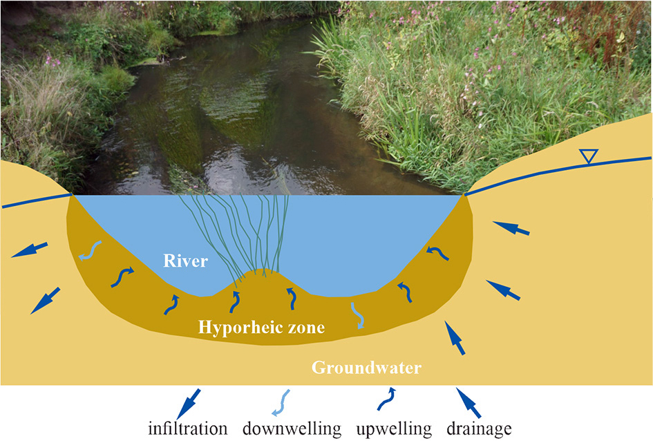
Fig. 1.
Water exchange in the hyporheic zone.
Research on hydrological, hydrogeological, and particularly hydrobiological processes in the hyporheic zone has led to a reassessment of their far-reaching implications for water quality and stream ecology (Boano et al. 2014). Macrophyte communities in spring niches depend on a continuous supply of relatively cold, thermally stable water that remains unfrozen during winter. High variability in redox conditions combined with low temperatures enhances nitrification, denitrification, and ammonification. Puczko and Jekatierynczuk-Rudczyk (2021) hypothesise that groundwater upwelling enriches surface water with nutrients, thereby influencing the development of plant communities. This process may be particularly significant in agricultural catchments, where nutrient oversupply promotes groundwater transport to watercourses. The hyporheic zone functions as a dynamic ecotone characterised by steep hydrological, chemical, and biological gradients. It plays a crucial role in the cycling and transformation of energy, carbon, and nutrients (Smith 2005). In most cases of groundwater upwelling, the water entering the river through the hyporheic zone is of higher quality than the river water, although its influx may trigger new metabolic processes within the ecosystem (Krause et al. 2022).
Water crowfoots constitute a taxonomic group of plants within the family Ranunculaceae, classified under section Batrachium in the morphologically and ecologically diverse genus Ranunculus (Hörandl, Emadzade 2012). These plants exhibit several adaptations enabling survival in aquatic environments. They can produce floating leaves on the water surface and submerged leaves adapted for underwater carbon dioxide assimilation; additionally, they can utilise bicarbonates when CO2 availability is limited (Iversen et al. 2019). Approximately thirty species of water crowfoots are recognised globally, occurring in both lotic and lentic habitats (Wiegleb et al. 2017). Most aquatic Ranunculus species are stenotopic, exhibiting narrow ecological tolerance and thriving only under specific environmental conditions. They are highly sensitive to changes, particularly to pollutants and variations in water pH and alkalinity (Onaindia et al. 2005, Hrivnáket et al. 2007, Iversen et al. 2019). Consequently, water crowfoots are used as bioindicators, as their presence reflects specific physicochemical parameters of the aquatic environment (e.g., Haury et al. 2006).
Water crowfoots exhibit sensitivity to the physical parameters of river habitats. Riverine Ranunculus species are generally associated with high current velocity (Wiegleb, Herr 1985, Haury 1996, Riis, Biggs 2003, Gebler et al. 2022) and coarser substrates, such as gravel or pebbles (Haslam 1978, Haury 1996, Riis, Biggs 2003, Mony et al. 2006, Hrivnák et al. 2007, Butkuvienė et al. 2018). These species typically occur in pristine rivers but can tolerate moderate hydro-morphological alterations (Riis, Biggs 2003, Mony et al. 2006, Gebler et al. 2022). Riverine communities of water crowfoots and other aquatic plants belonging to the associations Ranunculion fluitantis and Callitricho-Batrachion constitute habitats protected under the European Union’s Natura 2000 network (habitat 3260; Council Directive 92/43/EEC). Rivers and streams that support well-established communities of this type – commonly referred to as water crowfoot rivers – represent valuable landscape elements and provide essential habitats for the reproduction of rheophilic fish and numerous aquatic invertebrate species (Pinto et al. 2006). Therefore, protecting these habitats is crucial for maintaining biodiversity and preserving ecologically significant river ecosystems.
To ensure effective protection of naturally occurring water crowfoot species and their communities, it is essential not only to prevent pollution and degradation of riverine habitats but also to identify the ecohydrological factors governing their occurrence in the wild. The present study aimed to determine the drivers of water crowfoot growth in river ecosystems. We hypothesise that, once established in the riverbed, these macrophytes trap suspended sediments and, by clogging interstitial pores, reduce the groundwater inflow (upwelling). Since riverine Ranunculus species prefer upwelling zones, diminished groundwater inflow may lead to the gradual disappearance of vegetation clumps.
Materials and methods
The hydrological dynamics of the hyporheic zone colonised by water crowfoot patches were investigated using two instruments designed to measure hydraulic gradients and the filtration flux through clastic sediments: a filtrometer and a gradientometer. Details regarding the construction, operation, and calibration of these instruments are provided by Marciniak and Chudziak (2015). Measurement uncertainty was assessed through tests conducted on a specially designed laboratory bench. The results indicated that the relative uncertainty of the filtrometric and gradientometric measurements did not exceed 5%. In 2017 and 2018, two series of field surveys were conducted at 41 water crowfoot sites (Fig. 2). These surveys enabled the development of a methodology for performing filtrometric and gradientometric measurements in hyporheic zones colonised by water crowfoot patches.
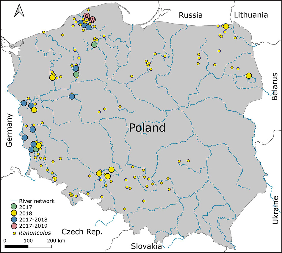
Fig. 2.
Study sites in rivers in Poland. The coloured circles indicate the locations of the one-time survey (in 2017 or 2018), the two-time survey (in 2017 and 2018), and the three-time survey (in 2017, 2018, and 2019). The letters G and W indicate the location of the areas where detailed surveys were carried out in the Glaźna River and Warblewska Struga River.
Filtrometric measurements were performed to quantify the variability of upwelling flux, whereas gradientometric measurements were used to determine the direction of water exchange between the river and the hyporheic zone. Reconnaissance surveys also supported the selection of polygons for detailed surveys in 2019. Polygons chosen for in-depth hydrodynamic analysis within hyporheic zones colonised by well-established Ranunculus patches were located outside the influence of anthropogenic pressures, including industrial, municipal, or agricultural pollution. These criteria were met by the rivers Glaźna and Warblewska Struga (Fig. 3), which flow approximately 8 km south of Słupsk into the Słupia River.
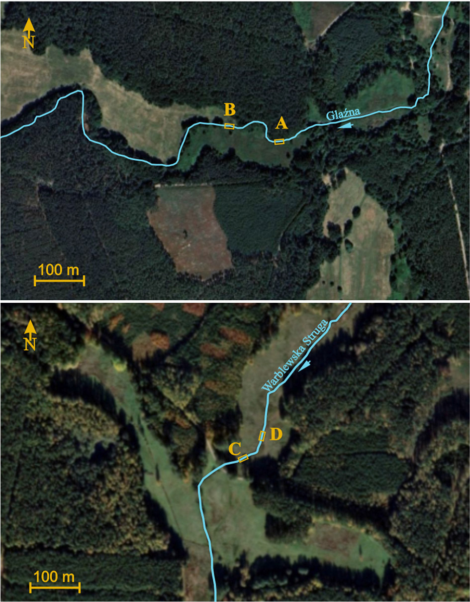
Fig. 3.
Location of testing polygons: A and B in the Glaźna River and C and D on the Warblewska Struga River.
The detailed filtrometric study aimed to assess the spatial variability of upwelling and downwelling fluxes within zones colonised by Ranunculus patches and adjacent unvegetated substrates. At each sampling site, the filtrometer’s steel dome was inserted twice into the riverbed: first within a macrophyte patch and then in the unvegetated river bottom. Gradientometric surveys were performed using six gradient gauges positioned in the hyporheic zone along successive cross-sections perpendicular to the river flow. Gradientometers were inserted into both macrophyte patches and unvegetated areas at each cross-section. This approach enabled the characterisation of variability and the direction of hydraulic gradients in hyporheic zones colonised by plants. Additionally, six substrate samples were collected for granulometric analysis: two from the root zone of water crowfoot clumps, two from the deepest parts of the channel, and two from approximately 50 cm depth (shallow zone) in unvegetated areas. The granulometric analyses aimed to evaluate the influence of water crowfoot vegetation on sediment grain-size distribution within the hyporheic zone.
Results
Filtrometric analyses
Filtrometric surveys conducted in 2017 and 2018 characterised the variability of filtration flux within river zones inhabited by water crowfoots (Ranunculus ssp.). The results demonstrated that upwelling was the prevailing process in the studied rivers, with mean fluxes ranging from 0.0521 to 0.0659 m3·d−1·m−2 and maximum flux values between 0.2341 and 0.4118 m3·d−1·m−2. Notably, interannual differences were observed, with filtration flux in 2018 being nearly 50% higher than in 2017.
In 2019, detailed filtrometric surveys were performed at four study polygons: A and B on the Glaźna River and C and D on the Warblewska Struga River. These surveys revealed distinct differences in upwelling flux between water crowfoot clumps and sandy bottom sediments. Variability in upwelling flux within Ranunculus clumps was minimal, generally not exceeding 0.5%, whereas flux variability on sandy substrates reached approximately 2.4%. Analysis of filtrometer measurements indicated that upwelling flux in water crowfoot zones was nearly five times lower (mean: 0.135 m3·d−1·m−2) compared to sandy bottoms devoid of vegetation (mean: 0.653 m3·d−1·m−2). Differences were less pronounced at polygons on Glaźna River and polygon D on Warblewska Struga River, where flux outside Ranunculus clumps was approximately 3.5–4 times higher. In contrast, polygon C exhibited the greatest disparity, with upwelling flux in unvegetated areas nearly seven times higher than within plant-covered zones (Fig. 4, Tables 1 and 2).
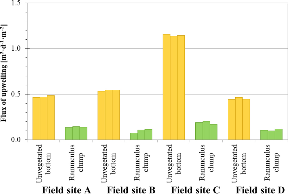
Fig. 4.
Comparisons of upwelling fluxes in unvegetated riverbed and within Ranunculus clumps.
Table 1.
The variation in filtration fluxes in the water crowfoot rivers measured in 2019.
| Year | N | Upwelling flux [m3·d−1·m−2] | |||||
|---|---|---|---|---|---|---|---|
| MIN | AVG | MD | MAX | SD | CV | ||
| 2019 | Unvegetated riverbed | ||||||
| 12 | 0.443 | 0.653 | 0.510 | 0.653 | 0.286 | 2.38% | |
| Ranunculus clump | |||||||
| 12 | 0.077 | 0.135 | 0.127 | 0.205 | 0.036 | 0.30% | |
Table 2.
Results of upwelling flux surveys carried out in 2019 in the water crowfoot rivers.
| The bottom of the river | River | Polygon | Upwelling flux [m3·d−1·m−2] | ||
|---|---|---|---|---|---|
| Unvegetated riverbed | Glaźna | A | 0.467 | 0.470 | 0.487 |
| B | 0.533 | 0.547 | 0.545 | ||
| Warblewska Struga | C | 1.156 | 1.136 | 1.144 | |
| D | 0.443 | 0.467 | 0.447 | ||
| Ranunculus clump | Glaźna | A | 0.137 | 0.147 | 0.140 |
| B | 0.077 | 0.110 | 0.116 | ||
| Warblewska Struga | C | 0.190 | 0.205 | 0.170 | |
| D | 0.107 | 0.100 | 0.118 | ||
Gradientometric analyses
Gradientometric surveys were carried out at the exact 41 locations as the filtrometric surveys. Reconnaissance measurements performed in 2017 and 2018 quantified the proportion of upwelling and downwelling within the hyporheic zone colonised by Ranunculus clumps, as summarised in Table 3. The data clearly indicate that upwelling – groundwater inflow into the riverbed – predominates in nearly 70% of observations. Interannual differences were minor compared to those observed for filtration, varying by only a few percentage points.
Table 3.
The variation of hydraulic gradient in rivers with water crowfoot vegetation measured in 2017 and 2018.
| Hyporheic exchange | N | Hydraulic gradient [cm·cm−1] | ||||||
|---|---|---|---|---|---|---|---|---|
| [–] | [%] | MIN | AVG | MD | MAX | SD | CV [%] | |
| 2017 | ||||||||
| Upwelling | 63 | 67.0 | 0.005 | 0.0538 | 0.0400 | 0.2700 | 0.0569 | 105.7 |
| Neutral | 8 | 8.5 | ||||||
| Downwelling | 23 | 24.5 | –0.245 | –0.0660 | –0.0350 | –0.0050 | 0.0750 | –113.6 |
| 2018 | ||||||||
| Upwelling | 99 | 70.2 | 0.005 | 0.0490 | 0.0350 | 0.3150 | 0.0440 | 91.5 |
| Neutral | 5 | 3.6 | ||||||
| Downwelling | 37 | 26.2 | –0.550 | –0.0800 | –0.0250 | –0.0050 | 0.1420 | –177.0 |
Detailed gradientometric surveys were conducted concurrently with filtrometric surveys at four research polygons on the Glaźna and Warblewska Struga rivers. Both the magnitude and orientation of hydraulic gradients in unvegetated substrate and within water crowfoot clumps varied among sites. The maximum gradient recorded was 0.145 cm·cm−1, with most values ranging between 0 and 0.5 cm·cm−1; a single negative gradient was also observed (Fig. 5 and Table 4). Variability in these measurements was substantial, and in some cases very high (Tables 4 and 5). For reconnaissance surveys conducted in 2017 and 2018, variability approached 100% (91.5% in 2018 and 105.7% in 2017). In contrast, detailed surveys performed in 2019 exhibited variability of approximately 70%, indicating that steep hydraulic gradients are characteristic of the hyporheic zone.
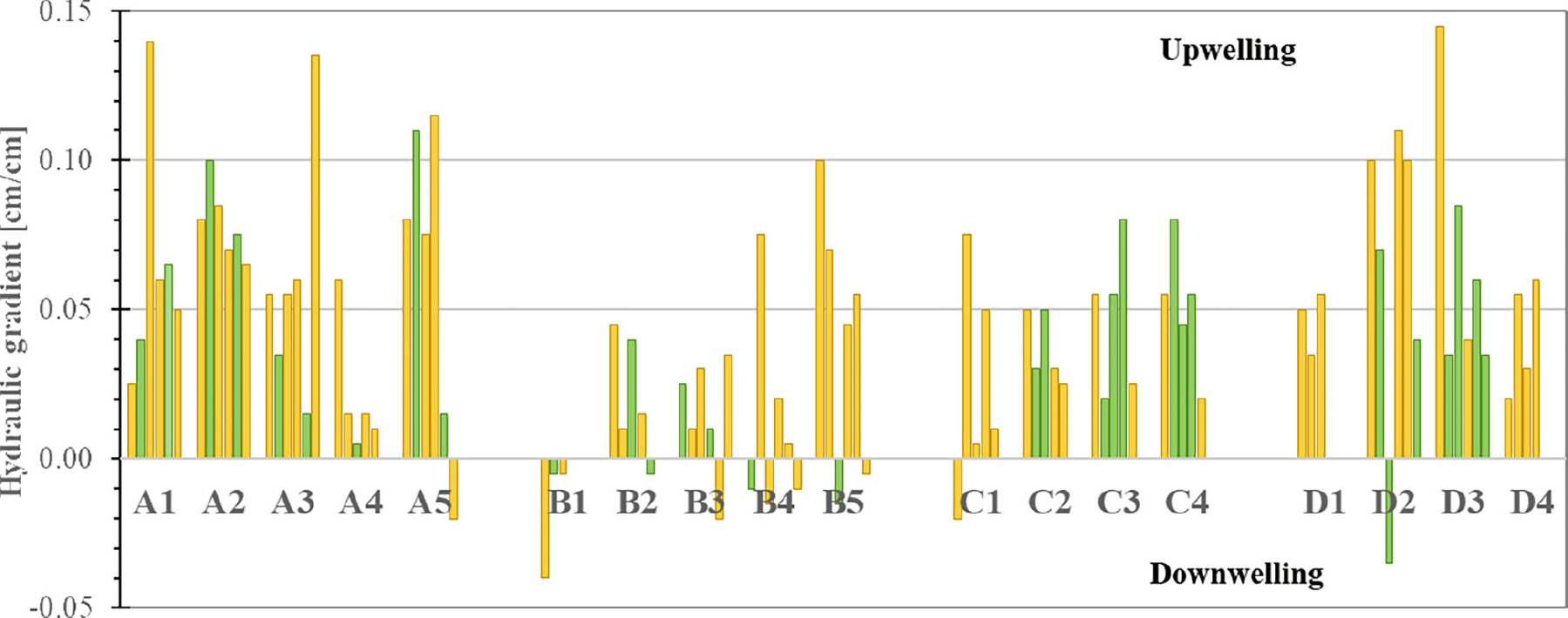
Fig. 5.
Results of gradientometric measurements recorded in 2019 in the unvegetated riverbed (yellow) and Ranunculus clumps (green).
Table 4.
Measured in 2019, the range of variation of hydraulic gradient in rivers with water crowfoot vegetation.
| Hyporheic exchange | N | Hydraulic gradient [cm·cm−1] | ||||||
|---|---|---|---|---|---|---|---|---|
| [–] | [%] | MIN | AVG | MD | MAX | SD | CV [%] | |
| 2019 Unvegetated riverbed | ||||||||
| Upwelling | 54 | 87.1 | 0.005 | 0.052 | 0.053 | 0.145 | 0.0341 | 65.7 |
| Neutral | 0 | 0.0 | ||||||
| Downwelling | 8 | 12.9 | –0.040 | –0.017 | –0.018 | –0.005 | 0.0106 | –62.7 |
| 2019 Ranunculus clump | ||||||||
| Upwelling | 35 | 85.4 | 0.005 | 0.048 | 0.040 | 0.110 | 0.0285 | 59.7 |
| Neutral | 0 | 0.0 | ||||||
| Downwelling | 6 | 14.6 | –0.035 | –0.013 | –0.010 | –0.005 | 0.0103 | –77.1 |
Table 5.
Results of vertical hydraulic gradient studies conducted in 2019 in rivers with water crowfoot (white colour – unvegetated riverbed, green colour – Ranunculus clamps).
| River | Field-site | Cross-section | Hydraulic gradient [cm·cm−1] | |||||
|---|---|---|---|---|---|---|---|---|
| Glaźna | A | A1 | 0.025 | 0.040 | 0.140 | 0.060 | 0.065 | 0.050 |
| A2 | 0.080 | 0.100 | 0.085 | 0.070 | 0.075 | 0.065 | ||
| A3 | 0.055 | 0.035 | 0.055 | 0.060 | 0.015 | 0.135 | ||
| A4 | 0.060 | 0.015 | 0.005 | 0.015 | 0.010 | |||
| A5 | 0.080 | 0.110 | 0.075 | 0.115 | 0.015 | –0.020 | ||
| B | B1 | –0.040 | –0.005 | –0.005 | ||||
| B2 | 0.045 | 0.010 | 0.040 | 0.015 | –0.005 | |||
| B3 | 0.025 | 0.010 | 0.030 | 0.010 | –0.020 | 0.035 | ||
| B4 | –0.010 | 0.075 | –0.015 | 0.020 | 0.005 | –0.010 | ||
| B5 | 0.100 | 0.070 | –0.015 | 0.045 | 0.055 | –0.005 | ||
| Warblewska Struga | C | C1 | –0.020 | 0.075 | 0.005 | 0.050 | 0.010 | |
| C2 | 0.050 | 0.030 | 0.050 | 0.030 | 0.025 | |||
| C3 | 0.055 | 0.020 | 0.055 | 0.080 | 0.025 | |||
| C4 | 0.055 | 0.080 | 0.045 | 0.055 | 0.020 | |||
| D | D1 | 0.050 | 0.035 | 0.055 | ||||
| D2 | 0.100 | 0.070 | –0.035 | 0.110 | 0.100 | 0.040 | ||
| D3 | 0.145 | 0.035 | 0.085 | 0.040 | 0.060 | 0.035 | ||
| D4 | 0.020 | 0.055 | 0.030 | 0.060 | ||||
Detailed filtrometric and gradientometric survey results obtained in 2019 are presented along cross-sections oriented perpendicular to the flow of the surveyed rivers. On the Glaźna River, surveys were conducted on two polygons (A and B), each comprising five cross-sections equipped with one filtrometer and six gradientometers. The results, presented graphically in Fig. 6, show that polygons C and D were located on the Warblewska Struga River, included four cross-sections per polygon, from which filtrometric and gradientometric measurements were collected (Fig. 7).
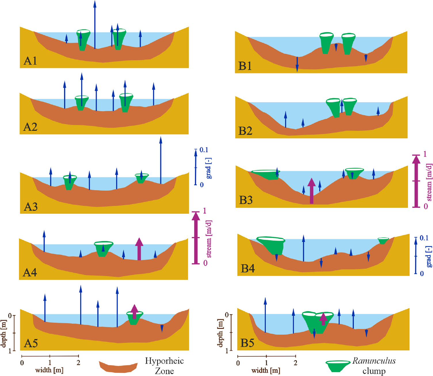
Fig. 6.
Results of filtrometric and gradientometric surveys carried out in 2019 at cross-sections A1, A2, A3, A4, and A5 and cross-sections B1, B2, B3, B4, B5, perpendicular to the current of the Glaźna River.
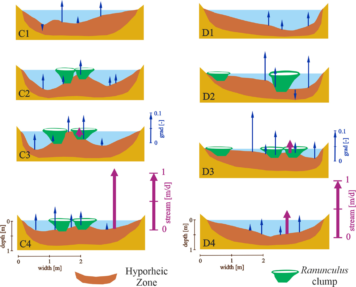
Fig. 7.
Results of filtrometric and gradientometric surveys carried out in 2019, at cross-sections C1, C2, C3, C4 and at cross-sections D1, D2, D3, D4, perpendicular to the Warblewska Struga river current.
Granulometric analyses
The results of the granulometric analyses of substrate samples collected from the upper and lower sections of the hyporheic zone and from water crowfoot patches are shown in Figure 8. These analyses revealed greater variability in bed material within the Glaźna River and differences in substrate grain size across the three study zones. In the Glaźna River, substrate heterogeneity was most pronounced. The highest proportion of fine fractions (primarily sand) occurred in shallow areas without vegetation, followed by zones covered with Ranunculus vegetation. In contrast, deeper sections of the river channel contained a higher proportion of coarse fractions (gravel). Conversely, the Warblewska Struga River was characterised by predominantly sandy substrate across all zones, with the finest fraction concentrated within the Ranunculus clumps.
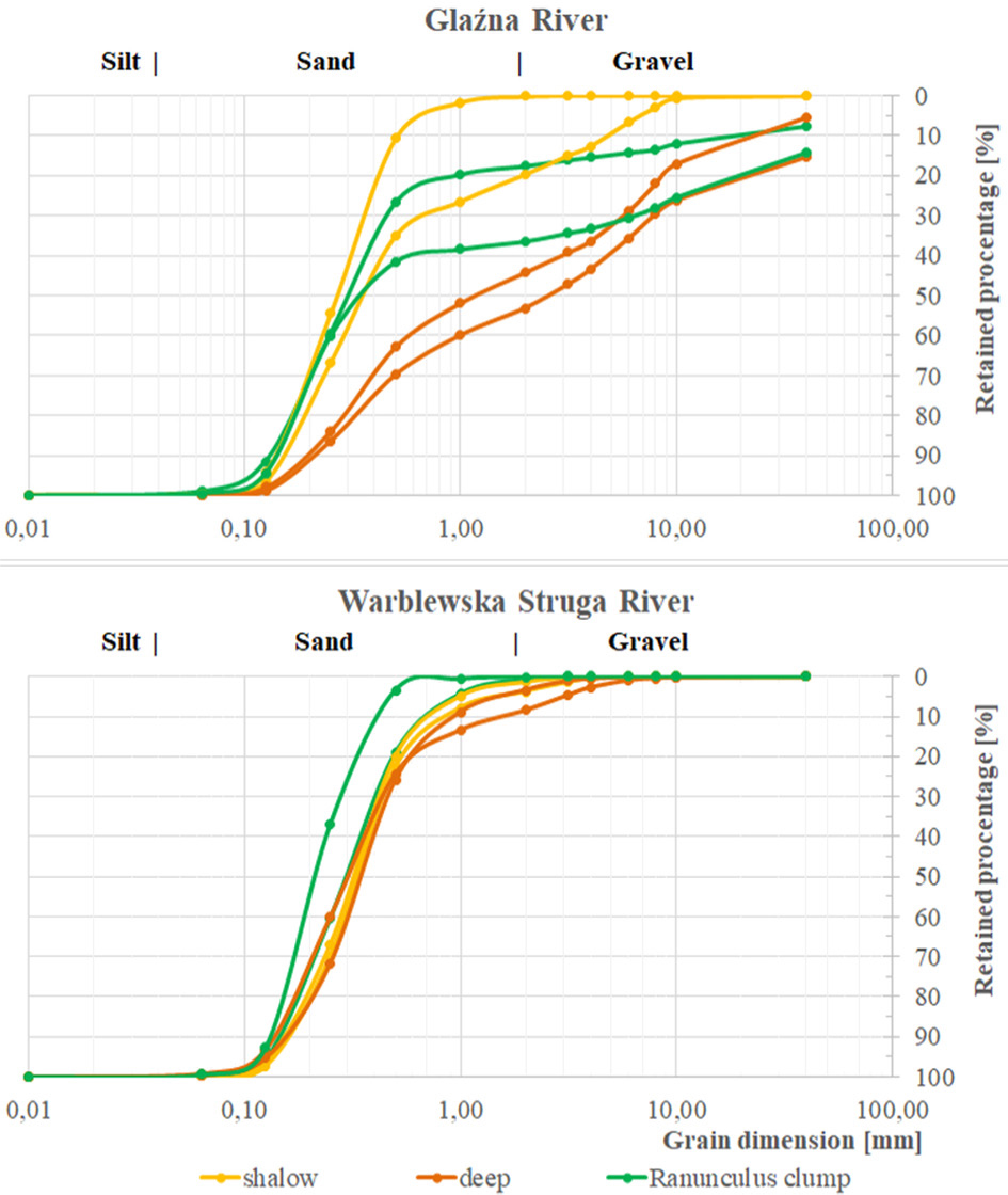
Fig. 8.
Grain size curves of substrate samples taken from the test plots on the Glaźna and Warblewska Struga rivers.
Discussion
Our studies of the riverbed geometry demonstrate that sediment accumulation by aquatic plants alters the riverbed morphology, forming hummocks beneath water crowfoot patches. Previous studies have noted that, once rooted, expanding clumps within the river channel act as obstacles that trap sediment transported by the current (Haslam 1978). This process is not unique to water crowfoot vegetation but occurs in numerous other aquatic macrophytes. The dynamics of hummock formation for several taxa have been described in detail by Haslam (1978), Hendricks and White (1988), and Madsen et al. (2001).
The hummock formation by water crowfoot species has been examined extensively, revealing that sediment within clumps typically remains above the root weft. Hummock thickness fluctuates with hydrological conditions, accumulating sediment during low-flow periods and eroding during storm events. Even when the upper sediment layer is removed, plants with deeply anchored root systems remain stable. Periodic hummock removal by intensified currents does not result in uprooting of entire vegetation patches (Haslam 1978).
Previous studies have demonstrated that the water crowfoot clumps are highly resistant to destruction during extreme hydrological events, significantly influencing the spatial distribution of other macrophyte species within the channel. This raises the question of what directly causes the disappearance of water crowfoot clumps at specific sites. Our findings indicate that sediment trapping by these plants reduces groundwater upwelling, potentially contributing to habitat degradation. Gradientometric analyses confirm that water crowfoot preferentially colonises upwelling zones (Marciniak et al. 2023, 2024). New clumps establish after shoots root in river sections characterised by strong upwelling; however, as clumps expand, they progressively deteriorate favourable habitat conditions. Filtrometer measurements revealed that upwelling flux was nearly five times lower in zones covered by water crowfoot (mean 0.136 m3·d−1·m−2) compared to unvegetated sandy bottoms (mean 0.653 m3·d−1·m−2). Average upwelling gradients were 0.050 cm·cm−1 in sand and 0.040 cm·cm−1 beneath water crowfoot clumps, which is a 20% reduction. Similarly, average downwelling gradients decreased from 0.017 cm·cm−1 in sand to 0.012 cm·cm−1 under vegetation, representing a 30% reduction. These patterns indicate that clumps substantially limit hyporheic water exchange.
Analysis of riverbed geometry revealed the formation of a hump resulting from hummock development. Granulometric analyses of sediments from zones both vegetated and unvegetated by water crowfoots showed that clumps contain a higher proportion of fine fractions. This suggests a dual effect of these clumps on the hyporheic zone: groundwater inflow is restricted by increased sediment deposition and pore clogging with fine-grained material. The establishment of water crowfoot clumps on coarse substrates such as gravel and stones is well-documented (Haslam 1978, Haury 1996, Riis, Biggs 2003, Mony et al. 2006, Hrivnák et al. 2007, Butkuvienė et al. 2018). Cook (1966) emphasised that sediment physical properties, rather than water hydrochemistry, are the primary limiting factors for the distribution of water crowfoot species. In rivers with lower flow velocities, silting of water crowfoot patches likely occurs more slowly.
Our research indicates that a decrease in groundwater upwelling during the development of water crowfoot clumps can substantially modify the physico-chemical characteristics of their habitat. Specifically, restricting groundwater flow into the root zone may elevate water temperature, particularly during summer months – a critical factor given that water crowfoot thrives in cooler conditions. Elevated temperatures can also indirectly reduce oxygen solubility. Furthermore, diminished groundwater input may increase pollutant concentrations due to reduced dilution by river flow. Previous studies suggest that water crowfoots favour environments with low water conductivity; therefore, reduced upwelling within the hyporheic zone affects multiple key parameters, many of which directly influence the aquatic conditions essential for their growth (Onaindia et al. 2005, Hrivnák et al. 2007).
Studies have shown that developing water crowfoot clumps induce several habitat changes that progressively deteriorate conditions for their own persistence. These include reduced groundwater upwelling, a decline in the proportion of coarse sediment fractions, and adverse physico-chemical shifts in water quality. Such processes may explain the movement and morphological changes of hummocks, as well as the cyclical disappearance of water crowfoot populations (Cook 1966). Habitat alterations can strongly affect the survival of water crowfoots, which are considered ecological specialists and sensitive indicators of environmental change (Haury et al. 2006, Szoszkiewicz et al. 2020).
Our study suggests that new hypotheses can be tested regarding how water-flow conditions in the hyporheic zone influence various components of the river ecosystems. Integrating hydraulic analyses, such as assessments of surface and groundwater gradients and flux density of water exchange in the hyporheic zone, with investigations of ecological interactions among macrophytes, benthic macroinvertebrates, algae, and fish could reveal previously unknown relationships shaping aquatic ecosystems. Although research in this area remains limited (Magliozzi et al. 2019, Lin et al. 2020, Grygoruk et al. 2021), advances in instrumentation for measuring hyporheic water exchange are expected to enable broader field investigations. The role of hyporheic exchange, already recognised as a key factor for river persistence (Jekatierynczuk-Rudczyk 2007, Lewandowski et al. 2020), may prove even more significant and complex than previously assumed. Observed seasonal and spatial variations in hydraulic gradients support the concept – consistent with the existing research – that steep hydraulic gradients characterise the hyporheic zone (Wondzell, Swanson 1999, Battin et al. 2003, Smith 2005, Tonina, Buffington 2007).
Conclusions
Our study revealed a previously unrecognised mechanism underlying the development of Ranunculus clumps, demonstrating that water exchange dynamics in the hyporheic zone are among the most critical factors for macrophyte growth. Gradientometric studies indicate that water crowfoot species preferentially colonise rivers with groundwater upwelling within the hyporheic zone. However, once established, clumps act as physical barriers that trap sediment transported by the current. This sediment-trapping process leads to the formation of hummocks on the riverbed where clumps of water crowfoots are rooted. Granulometric analyses confirmed that these hummocks contain a higher proportion of fine sand fractions. Filtrometric measurements further demonstrated that groundwater upwelling flux into the river is significantly reduced beneath these clumps. Such a decline in groundwater upwelling during the clump expansion can negatively affect habitat conditions. Insufficient groundwater inflow from the hyporheic zone may result in elevated water temperatures and reduced water quality within the root zone. These changes represent critical factors contributing to the decline of water crowfoot patches and their subsequent migration within the river channel.
Acknowledgement
We would like to thank the employees of the Słupia Valley Landscape Park for their assistance with field research. The proofreading was done using Copilot software; verification was not automatic, but each suggested correction was verified by the authors.
The authors thank the reviewers for their detailed comments, which helped improve this manuscript.
Notes
[1] Contributed by Author’s contribution
DG: conceptualisation, methodology, field research, writing – original draft. MM: conceptualisation, methodology, field research, data curation and analysis, visualisation, writing – original draft. MG: conceptualisation, writing – review & editing. JZ-G: writing – review & editing. KS: conceptualisation, methodology, field research, writing – original draft.