
Introduction
Debris-flow cones, mudflow, and rockfall-debris avalanche tongues resulting from high-energy, short-lived slope (denudational) processes are widely recognised and described within the alpine zone of high mountain areas (White 1981, Zimmermann 1990, Kotarba 1992, Rączkowska 2006, Kapusta et al. 2010) as well as in forested middle mountains (e.g., the Beskids, the subalpine zone of the Tatras) (Starkel 1960, Ziętara 1999, Gorczyca et al. 2014, Panek et al. 2025). Debris-flow cones located at the foot of rock walls in the Tatra Mountains are classified as aggradational landforms, commonly referred to as alluvial talus cones. These forms are generated during short-lived, high-intensity convective rainstorms lasting only several to a dozen minutes, yet they retain their morphology for many decades or even centuries (Kotarba 1992). A convective rainfall event in the Bieszczady Mountains on Połonina Wetlińska (1232 m a.s.l.) on 28 June 2018, with a total precipitation exceeding 50 mm within 3 h, triggered debris flows in one of the tributary valleys of the upper San River, as recorded by staff of the Bieszczady National Park (Gębica et al. 2019).
Our knowledge regarding the occurrence and development of debris-flow (torrent) cones in the foothill zone of the Carpathians (300–500 m a.s.l.) remains limited. Small, forested, V-shaped valleys subject to morphological transformation by debris and mudflows have been observed only sporadically in the foothill regions (Cebulak et al. 2008, Gębica et al. 2019). During the July 2005 flood event, L. Starkel documented a debris flow in the foreland of the Bieszczady Mountains within a small-incised valley, where a torrential cone had developed at the valley mouth (Cebulak et al. 2008). In the Brzanka Range (Ciężkowice Foothills), within a forested slope at the foot of Rysowany Kamień Mt., P. Gębica observed the geomorphic effects of a mudflow initiated by intense rainfall in March and April 2000 (Gębica et al. 2019).
The opportunity to study debris-flow cones and other erosional and depositional forms arose from field observations following intense rain-fall and flash floods in small catchments of the Carpathian Foothills in June 2020.
There is no universally accepted terminology or genetic classification for the cones described in this article. According to Klimaszewski (1978), proluvial cones belong to the category of slope landforms formed by the deposition of proluvial sediments transported by rainwater (including ablation runoff) at the foot of mountain slopes. Książkiewicz (1979) defines these features some-what differently, describing them as landforms ‘formed during heavy rainfalls at the mouths of short mountain streams, i.e., of permanent water-courses. These generate proluvial cones that are typically steeper than alluvial cones and are generally composed of coarse, poorly rounded clastic material (Jaroszewski et al. 1985).
Another term used in geomorphology to describe fan-shaped accumulations of blocks and boulders embedded in a silty-clayey matrix on steep surfaces at the outlets of narrow valleys is torrential cones. According to Klimaszewski (1978), torrential cones represent a transitional form between debris tongues and alluvial cones, and are classified as fluvial accumulative landforms. These are steep cones (slope angles >10°) ‘extending at the mouths of steep incised V-shaped valleys in mountainous and upland regions, composed of coarse, angular material (blocks and boulders) embedded in a silty-clayey matrix. In contrast, alluvial cones have gentler slopes (typically 2–7°) and consist of both rounded and angular material, usually with well-developed stratification. Different slope ranges for debris-flow fans and alluvial fans are provided by Dikau et al. (1996). For debris-flow fans, slope gradients range from 0.05 to 0.2, that is 3–11° (5–20%), whereas most alluvial fans exhibit gradients below 2.5°. These values are consistent with the classification proposed by Jackson et al. (1987), who, based on a morphometric analysis of landform fans and catchment parameters in the Rocky Mountains, determined that the slope of debris-flow fans exceeds 4°.
Starkel (1960) used the term alluvial–torrential cones to emphasise the complex genesis of such landforms. A similar term – colluvial-alluvial fans – was introduced by Fernald et al. (1968) to describe fans formed by smaller streams emerging from mountainous areas, whereas alluvial fans in the strict sense are formed by larger rivers. An interesting example of a large alluvial cone located on the foreland of the Southern Alps in New Zealand, with a significant contribution of debris-flow deposits, is described by Pierson (1980). In Van Dine’s (1985) classification of debris flows, a specific subtype called debris torrent (channelised debris flow) is distinguished. Material transported by debris flows accumulates at the slope base, forming depositional features such as cones, tongues, lobes and levees described in this study.
This article aims to emphasise that the exceedance of critical thresholds and the initiation of debris flows are not limited to high-mountain regions and forested middle mountains. Moreover, we aim to demonstrate that the formation of debris-flow cones in the foothill zone of the Carpathians is also associated with shortlived, high-intensity rainfall events occurring in very small V-shaped valleys. Field observations supported by Digital Elevation Model (DEM) analysis allowed for the identification of several cone types, characterised by distinct morphology and internal structure. An attempt was also made to estimate rainfall threshold values that trigger debris flows and result in the formation of debris cones, with reference to neighbouring mountainous regions.
Study area
The study area is located in the eastern part of the Polish Flysch Carpathians and encompasses the southern (right-bank) portion of the middle San River basin within the boundaries of the Przemyśl Foothills (Solon et al. 2018) (Fig. 1A, B). According to geomorphological classifications (Starkel 1972, Gilewska 1986), the Przemyśl Foothills do not constitute a separate geomorphological unit but are part of the Dynów Foothills. This is a region with elevations ranging from 300 m a.s.l. to 500 m a.s.l., composed of steeply inclined folds and imbricated thrust sheets trending NW–SE, belonging to the Skole Nappe (Kotlarczyk 1988, Rauch et al. 2018). The Skole Nappe is built of complexes of shale–sand-stone, and sandstone lithofacies (Inoceramian Beds) of the Carpathian Flysch, deposited from the Upper Cretaceous to the Oligocene.
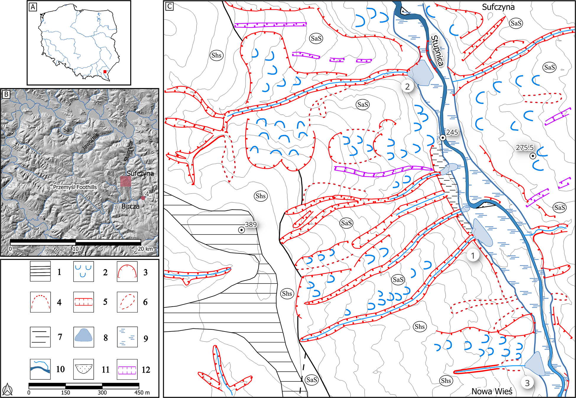
Fig. 1.
A – Location of the study area in south-eastern Poland, as shown in Figure 1B. B – Location of the detailed study area shown in Figure 1C, overlaid on the landforms and river network of the middle San River basin (Przemyśl Foothills). The map indicates the location of fan delta No. 4. C – Geomorphological map of the studied cones and incised V-shaped valleys in the Stupnica River valley. Debris-flow cones numbering (1–3) corresponds to descriptions in the text. 1 – ridges, 2 – landslide tongues, 3 – distinct landslide niches, 4 – indistinct landslide niches, 5 – incised V-shaped valleys, 6 – trough-shaped (dellen type) valleys, 7 – foot of the escarpment slope, 8 – debris (torrent) cones, 9 – floodplain, 10 – streams and riverbeds, 11 – point bars, 12 – road cuts. Lithological complexes: Shs – shales with sandstone intercalations; SaS – medium- to thin-bedded sandstones with shale intercalations. Lithological boundaries after SMGP 1:50 000 (Rauch et al. 2009) and field observations.
Overlying these bedrock units are Quaternary deposits in the form of weathered loams, debris–loam slope deposits, and alluvia (gravel, sand and river silts) (Zuchiewicz, Zasadni 2010). According to the landform typology proposed by Starkel (1972), the area is dominated by mid-elevation foothills, with local fragments of higher foothills where relative relief exceeds 150 m. Ridge crests typically reach 400–500 m a.s.l. The slopes are steep, convex or convex–concave in profile, and dissected by systems of deeply incised valleys (v-shaped valleys) ranging in length from several 100 m to a few kilometres. These valleys have narrow, rock-cut or mixed rock–alluvial valley floors and steep longitudinal gradients, and are drained by permanent streams. Numerous land-slides occur on the valley slopes. In some places, landslides occupy entire hillslopes – for instance, on the left slope of the Stupnica Valley between Bircza and Nowa Wieś (Pękala 1964, Rauch et al. 2009, 2018) – and serve as a source of slope-derived material supplied to the valley floors.
The floors of the larger valleys are flat-bottomed and terraced, typically 100–200 m wide, dissected by river channels. The main valleys trend predominantly in a meridional (north-south) direction, while the tributary valleys often follow subsequent, sub-latitudinal courses (Zuchiewicz, Zasadni 2010). The area is approximately 65% forested.
The study of torrent cones was conducted in the Stupnica Valley catchment and supplemented with observations from the neighbouring Jawornik Valley, both right-bank tributaries of the San River (Figs 1A, B). The Stupnica Valley is 25 km long and has a predominantly meridional course. Its catchment area is approximately 190 km2. The river’s headwaters are located in the Sanocko-Turczańskie Mountains, near the European watershed divide, at an elevation of 550 m a.s.l. The Stupnica discharges into the San River at an elevation of 216 m a.s.l. The major tributaries of the Stupnica River converge concentrically within the Bircza Basin (Starkel 1972). During flood events (e.g., in April 2009), the superposition of flood waves from the tributaries leads to inundation of the floodplain by 1.5–2 m (Gębica et al. 2019). The V-shaped valleys and associated debris-flow cones that are the subject of this study are located on the left-bank section of the Stupnica Valley, near the villages of Nowa Wieś and Sufczyna, approximately 2.2–3.5 km north of the centre of Bircza (Fig. 1C).
Atmospheric precipitation displays considerable spatial and temporal variability due to environmental controls, primarily elevation and relief. Mean annual precipitation totals range from 700 to 800 mm in the northern part of the Dynów Foothills during the period 1961–2010 to 800–950 mm in the south-eastern sector of the Przemyśl Foothills; in the Bieszczady Mountains, they exceed 1200 mm (Gębica et al. 2019). Monthly precipitation totals vary widely, from only a few millimetres in exceptionally dry months to >400 mm in the wettest summer months, including July 1980 (Cebulak et al. 2008). Under high-intensity precipitation events, short-interval totals (10 min) may exceed 20 mm, while hourly totals may reach up to 70 mm.
Materials and methods
During a field survey following the June 2020 flood event, reconnaissance observations were carried out along the valleys within the catchments of the Stupnica and Jawornik rivers. The fieldwork involved documenting geomorphological changes (both erosional and depositional) on hillslopes and within the valley floors. Locations of these forms were recorded in the field using a Global Positioning System (GPS) receiver. In areas of major disturbance – exhibiting the most pronounced erosional and depositional changes (e.g., damaged bridges, deepened channels, aggradation in channels and sedimentation on the floodplain, debris-flow cone deposition, landslides and earth flows on slopes) – detailed morphological descriptions and photographic documentation were conducted (Fig. 2).
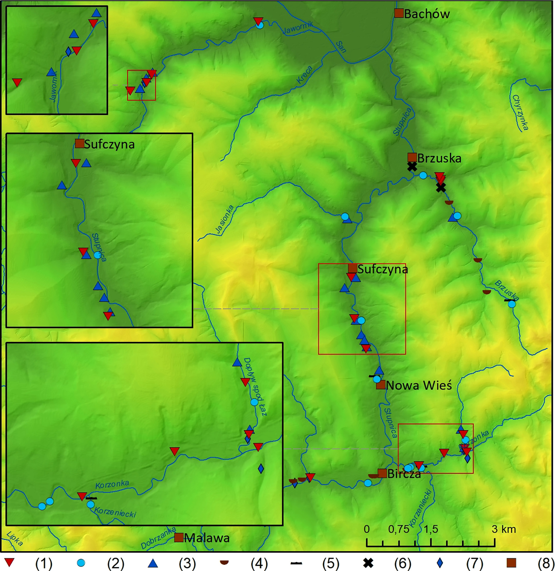
Fig. 2.
Effects of the flash flood in the Stupnica and Jawornik catchments (the San tributaries) in the Przemyśl Foothills. 1 – channel erosion, 2 – deposition in the channel and on the floodplain, 3 – debris-flow (torrents) cones and alluvial cones, 4 – landslides and earth flows, 5 – tree jams, 6 – destroyed bridges, 7 – flooded houses, 8 – settlements.
In the Stupnica Valley, north of Bircza, detailed geomorphological mapping was carried out for selected cones and V-shaped valleys (Fig. 1C). At the mouths of the incised valleys, the length, width and thickness of torrent cones were measured, along with the type and grainsize distribution of deposited debris (Table 1). Shallow test pits were excavated to determine the thickness and internal structure of the deposits. In the Korzonka stream (tributary of the Stupnica River), east of Bircza, measurements and a structural description were made of a fan delta (no. 4 on the location map – Fig. 1B). A video recorded by the fire service and published online was used to reconstruct the development of the fan delta and estimate the height of the flood wave. Since the debris cones accumulated at the outlets of V-shaped valleys, measurements included the length, width, slope gradient and incision depth of the valleys, as well as the type and maximum clast size of transported rock material (Table 2). Field investigations in the Stupnica and Jawornik catchments were supplemented by landform analysis based on a DEM (GUGiK 2025). The analysis included measurements of the area of V-shaped valley catchments, their length, slope gradient, and incision depth. Additionally, in one of the steep forested gullies (pol. debrza) within the Strug catchment (part of the Wisłok river basin) in the Dynów Foothills, the effects of a mixed earth-and-wood debris flow were documented following intense rainfall on 21–22 June 2020.
Table 1.
Morphometric characteristics of cones and the type and fraction of material deposited at the mouths of V-shaped valleys during the torrential rainfall on 26 June 2020, in the Stupnica Valley (Przemyśl Foothills).
| No | Type of cone | Length | Base width | Height | Slope | Type of sediments | Thickness | Maximum particle size |
|---|---|---|---|---|---|---|---|---|
| [m] | [%] | [cm] | ||||||
| 1. | Debris | 20 | 50 | 2.0 | 5.5 | Boulders, gravels, tree logs, cobbles | 20–40 | 75 × 40, 70 × 45, 70 × 20, 57 × 39, 49 × 12, 40 × 15, 30 × 15, 30 × 17, 20 × 11, 16 × 7 |
| 2. | Debris | 96 | 90 | 4.7 | 5.8 | Boulders, cobbles, soil aggregates, sand | 10–60 | 92–50 |
| 3. | Muddebris | 47 | 55 | 4.5 | 6.4 | Silt, cobbles, soil aggregates, boulders, tree logs, branches | 30–40 | Boulders (50–40) cobbles (30–20) |
| 4. | Silty-sandy | 30 | 16 | 1.0 | 1.0 | Silt, sand, plant detritus, small wood, tree trunks | 35–107 | 0.2–0.05 |
Table 2.
Morphometry of incised V-shaped valleys and cone surface area in the Stupnica catchment (Przemyśl Foothills) formed as a result of the extreme rainfall on 26 June 2020.
| No. | Type of valley | Height max | Height min | Length | Slope | Catchment area | Cone surface area |
|---|---|---|---|---|---|---|---|
| [m a.s.l.] | [m] | [%] | [km2] | [ha] | |||
| 1. | V-shaped | 373 | 252 | 900 | 13.4 | 0.12 | 0.26 |
| 2. | V-shaped | 378 | 252 | 1100 | 11.5 | 0.53 | 0.55 |
| 3. | Trough-V-shaped | 312 | 257 | 400 | 13.7 | 0.03 | 0.22 |
| 4. | V-shaped | 445 | 283 | 3500 | 4.6 | 2.88 | 0.05 (0.09*) |
| 5. | V-shaped | 392 | 248 | 1650 | 8.7 | 1.40 | 1.00 |
* value in parentheses indicate the cone surface area, including the built-up area (inaccessible for research), where accumulation was also observed. The numbering of the selected valleys and cone surface areas (Nos. 1–4) in the table corresponds to the sequence in which they are discussed in the text.
The numbering of the cone types highlighted in the table corresponds to the order of their description in the text.
To analyse the meteorological conditions and the course of precipitation, measurement data from the observational network of the Institute of Meteorology and Water Management – National Research Institute (IMGW-PIB) were used, as well as high-resolution (1 km × 1 km) radar data from the POLRAD meteorological radar network. Additionally, the RainGRS product was employed – a composite precipitation field at the ground surface level derived from rain gauge, radar and satellite data, representing the best available estimation obtained through the integration of multiple data sources. Based on station measurements (Fig. 3) and meteorological radar data, a spatial precipitation distribution map was developed to estimate precipitation in areas not covered by the gauge network. The spatial distribution of the IMGW-PIB stations is shown in Figure 4.
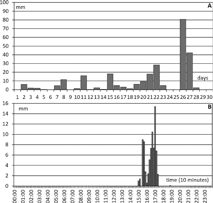
Fig. 3.
A – Daily precipitation totals in June 2020 at the Bircza weather station (Archival data, IMGW-PIB). B – Ten-min precipitation sums at the Bircza station on 26 June 2020 (Archival data, IMGW-PIB).
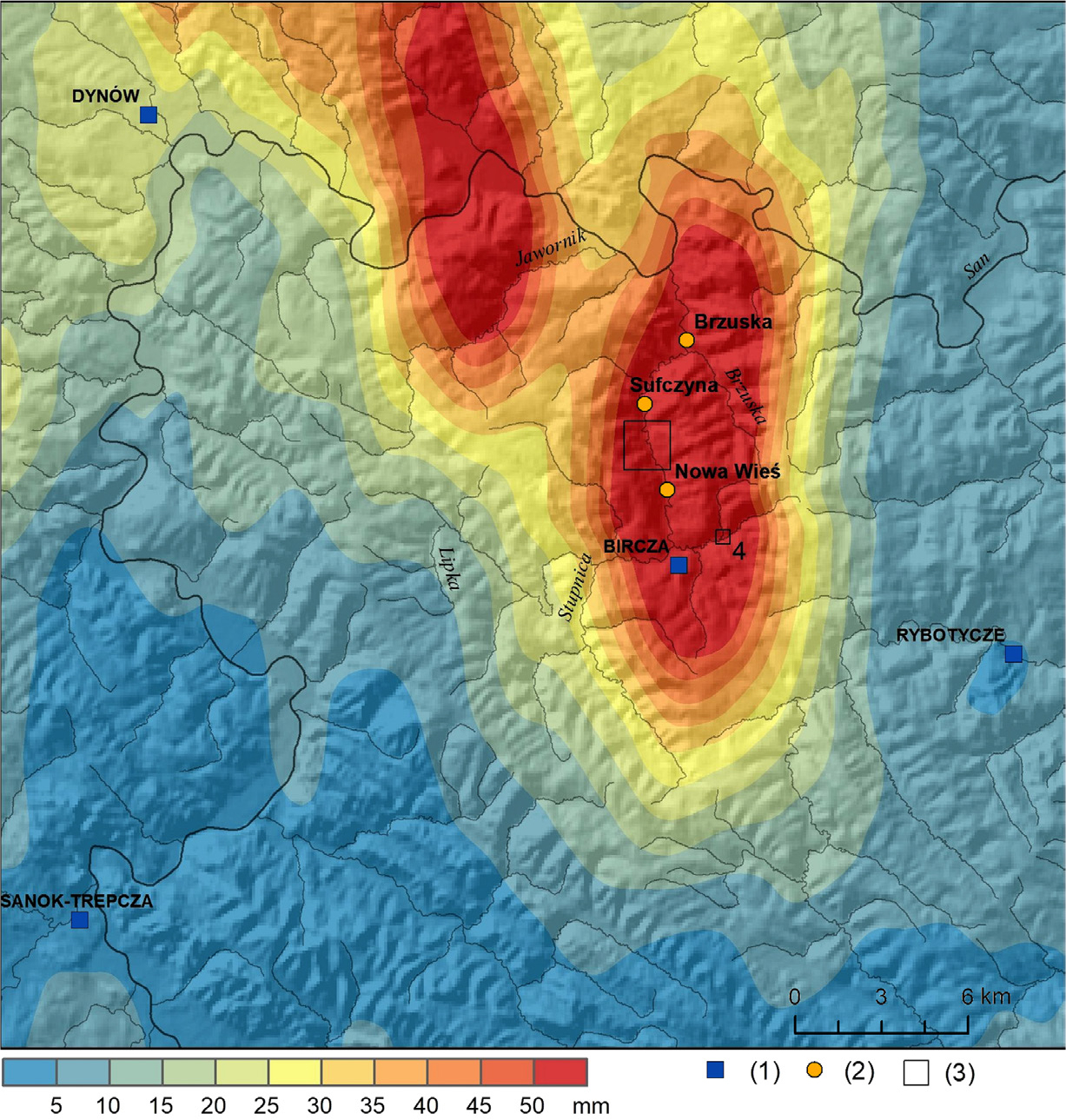
Fig.4.
Radar image of storm cells showing the spatial distribution of the maximum rainfall intensity index in the Stupnica and Jawornik catchments on 26 June 2020 (source: Archival data, IMGW-PIB). 1 – precipitation monitoring stations, 2 – other localities mentioned in the article, 3 – detailed study area (see Fig. 1C), No. 4 marks the fan delta at the outlet of the Korzonka stream tributary.
The basis for determining precipitation intensity, expressed as the so-called precipitation efficiency coefficient (a), is the Chomicz classification (1951). This classification is based on two parameters: total precipitation in millimetres and the duration of the precipitation event in minutes. Daily precipitation totals were used as background data; in this case, the precipitation day is defined as lasting from 8:00 a.m. local day-light saving time on the current day to 8:00 a.m. on the following day.
Cartographic elaborations (e.g., the map of geomorphological effects of the flood – Fig. 2) were prepared using Geographical Information System (GIS) techniques in ArcGIS Pro (Esri, Redlands, CA, USA) software, utilising spatial layers from the 10 × 10 m resolution DEM and the Hydrographic Division Map of Poland (MPHP) at a scale of 1:10,000. The English designations of physico-geographical mesoregions applied in this study are according to Solon et al. (2018).
Results
Meteorological conditions and precipitation in June 2020
In terms of precipitation, June 2020 was extremely or very wet across most of Poland (PSHM Bulletin, June 2020). Precipitation in the region began as early as 23 May 2020. According to IMGW-PIB observations, many measurement stations in southern Poland recorded monthly precipitation totals exceeding 100 mm, and in some locations even 200–400 mm. Daily precipitation totals exceeding 50 mm were recorded at >25 IMGW-PIB stations on 17–22, 26 and 27 June.
In June 2020, heavy rainfall was observed across almost the entire Carpathian Foothills zone, with particular intensity during the third decade of the month. These conditions led to local flash floods and inundations in the Stradomka River basin in the Wieliczka Foothills and in small catchments within the Dynów Foothills, Przemyśl and Strzyżów Foothills and Rzeszów Foothills (Podgórze Rzeszowskie), as well as the Jasło-Krosno Basin.
At the beginning of the third decade of June, the south-eastern part of Poland was located at the edge of a low-pressure system over the Black Sea, within a very warm and humid maritime polar air mass. Convergence lines and high cloud water content were present over the study area, and due to weak air advection, storm cells moved very slowly. In some places, storm cells became stationary, which, especially in favourable morphological conditions, resulted in locally heavy and torrential rainfall, and a point-based accumulation of high rainfall totals.
On 21–22 June, intense rainfall occurred in the Dynów and Przemyśl Foothills as well as the Rzeszów Foothills, caused by both short-duration storm events and continuous precipitation. Intermittent light showers occurred as early as 21 June, but after 19:00 local time, rainfall became more persistent with breaks, reaching its highest intensity in Kańczuga (Rzeszów Foothills) between 19:50 and 20:10, with a total of 9.8 mm.
On 22 June, convective processes began to intensify in the late morning hours in the eastern part of the study area. Initially, they appeared as isolated and scattered storm cells, but over time they merged into multi-cellular storm clusters moving south-westward. During this period, locally heavy and torrential rainfall occurred. In Kańczuga, a maximum instantaneous rainfall total of 6.5 mm was recorded over 10 min.
Around 20:00, the study area once again came under the influence of continuous precipitation (Fig. 3A), associated with a stationary occlusion front over the eastern part of the country. Unlike previous episodes, this precipitation was more stratiform in character, with lower short-term intensities but longer duration, which could have contributed positively to water retention in some catchments. Over the course of these 2 days, total rainfall reached approximately 50 mm, resulting in a sudden rise in water levels in small valleys of the Dynów and Przemyśl Foothills and the Rzeszów Foothills (Fig. 3A).
A second intense rainfall episode occurred in the Przemyśl and Dynów Foothills on 26–27 June. During this period, the study area was situated between a low-pressure system over the British Isles and a high-pressure system near the Black Sea, which brought in warm and humid maritime polar air from the south.
On the morning of 26 June, dynamic convective development began, leading in the afternoon to the formation of multi-cellular storm clusters that moved slowly, initially from the southwest to the northeast, and later northward and north-eastward across the foothill areas. According to IMGW-PIB data, the first episode of intense rainfall in Bircza occurred between 15:20 and 15:40, with a total of 17.6 mm (Fig. 3B). Another surge in rainfall intensity took place after 17:00, when 15.4 mm fell within 10 min. As the storm cell moved across the study area, the surface rainfall intensity (SRI) index locally reached up to 100 mm h−1 in the Stupnica catchment. The spatial distribution of rainfall in the study area is shown in Figure 4.
Spatial analysis of RainGRS precipitation data, calibrated against ground-based observations, indicates that in some locations both rainfall intensity and totals were likely higher than those recorded at fixed stations. In Bircza, the estimated hourly total precipitation between 16:10 and 17:10 reached 52.5 mm, corresponding to a Chomicz rainfall efficiency coefficient (a) of 6.8 – classified as a torrential rainfall of the 5th degree, category B1. During this episode, a total of approximately 80.7 mm of rain was estimated to have fallen in Bircza between 15:00 and 17:20, representing the daily rainfall total for that day (Figs 3A, B).
The following day (27 June), over the Jasło Foothills and Gorlice Depression, specifically in the Ropa River valley, further convective cells developed under favourable atmospheric conditions. These cells formed a multi-cellular storm system moving zonally eastward, creating a phenomenon known as training storms, i.e. a series of storm cores following the same path. By 18:50, the system reached the Stupnica catchment.
Before the storm cell reached this area, intense thunderstorm rainfall was recorded near Jasło town, with a total of 100.7 mm, corresponding to a rainfall efficiency coefficient a = 5.8, which again denotes torrential rainfall of the 5th degree (B1) according to Chomicz (1951). Additionally, the maximum recorded 10-min total was 20.3 mm, indicating an extreme intensity of 2 mm·min−1.
A few minutes later, the core of one of the storm cells passed over the study area, bringing further intense rainfall. Local precipitation totals reached 13 mm in 10 min, corresponding to a = 4.1, which is classified as heavy rainfall of 4th degree, category A4.
Debris-flow (torrent) cones and related geomorphological features formed during catastrophic rainfalls in June 2020
Intense rainfall on 21–22 June caused rapid flash floods in small rivers and streams across the Dynów and Przemyśl Foothills. In the Rzeszów area, the effects of the 22 June storm and flooding were observed in small V-shaped gullies within the Strug catchment (a sub-basin of the Wisłok River). According to data from the RainGRS system (IMGW-PIB), local precipitation on that day may have reached 60–80 mm in the Rzeszów region.
On a forested slope dissected by steep dry valleys, a mud-and-wood flow occurred in one of the valleys. Adjacent to a forest road, several cubic metres of soil-debris wood mass (including uprooted stumps, logs and branches – partly waste wood) detached and flowed downhill, carving out the valley floor and slopes. Vegetation growing on the valley sides and floor was eroded to a height of 2 m (Fig. 5). Over a section of several dozen metres, silty and clayey sediment (mud aggregates and cohesive clasts) and woody debris accumulated along the valley floor. In the neighbouring gullies, no similar effects were recorded on 22 June. However, the mainstream channel in the valley was deepened by approximately 1 m. Notably, during the subsequent flood on 26 June, the water level did not reach the high mark of 22 June, which remained the maximum for that particular valley.
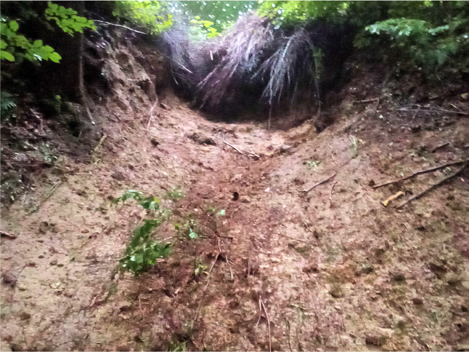
Fig. 5.
Erosion in the headwater section of a dry small valley (pol. debrza) caused by an earth-organic debris flow following a downpour on 22 June 2020.
The peak of the torrential rainfall on 26 June 2020, triggered a rapid flood wave in the small valleys of the Przemyśl Foothills. Such destructive surges are referred to as flash floods. They are characterised by a very rapid onset, short duration, limited spatial extent, but significant local damage and losses (Fig. 2). Due to high rainfall totals (daily precipitation at the Bircza station reached 80 mm – Fig. 3A) and their very short duration, the water level in the Stupnica River valley and its tributaries rose abruptly by 2–3 m. The hydrological response of the catchment was almost immediate, occurring within a few hours. The most effective erosion processes occurred in steep, short headwater valleys (0.4–1.5 km long, slope gradients of 9–13.5%) that dissect the slopes of the Stupnica and Jawornik valleys (Figs 1B, C and 2; Tables 1 and 2). Debris-flow cones were deposited at the outlets of these valleys.
Debris cone and feeder (source) V-shaped valley No. 1
The debris cone is located in the marginal part of the floodplain at the foot of a ca. 20-m-high scarp, which has been incised by a V-shaped valley. The scarp was formed as a result of lateral erosion by the Stupnica River, whose current channel lies approximately 150–200 m to the north-east of the studied cone. The original extent of the cone was larger and is indicated on the map (Fig. 1C). The field measurements do not include the portion of material that was deposited on the asphalt road and later removed by road maintenance services.
The cone has a regular shape, with both flanks being similar in length (18–21 m), and a total axial length of 16 m (Table 1). The headcone (apex of cone) is convex in profile and composed of the coarsest debris (Fig. 6A). The maximum measured size of sandstone blocks (longest axis) is 75 cm (Table 2). On the cone surface, minor siltstone cobbles (ca. 13 cm in diameter) and debarked tree trunks measuring 132–160 cm in length and 13–36 cm in diameter can be observed.
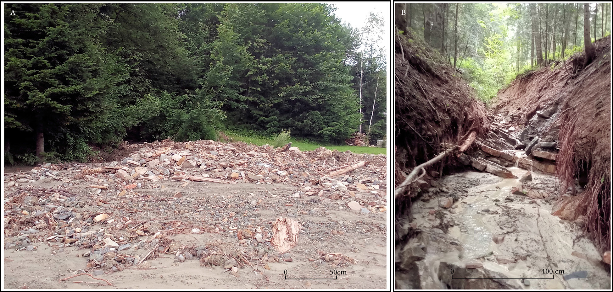
Fig. 6.
A – Debris-flow (torrent) cone No. 1. The convex lobate landform of mid-fan with coarse deposition of boulders, pebbles, and wood debris. In the foreground, a clear boundary is visible between proximal-fan gravel deposition and distal-fan sand and silt deposition. B – The bedrock channel of the V-shaped valley was deepened and widened as a result of a debris–mud flow event on 26 June 2020.
Three shallow test pits were excavated on the cone. In the highest pit (to a depth of 0.2 m), coarse and medium gravel predominated, along with siltstone aggregates and clasts resting on boulders. In the second pit, situated lower on the cone (to a depth of 0.25 m), sandy silt was found overlying coarse gravel. In the third pit, located in the lowest (distal) part of the cone, sandy-silty sediments with gravel were recorded to a depth of 0.4 m. Thus, the cone exhibits internal stratification and a fining of sediments towards its margins. Given the cone’s surface area of 0.26 ha and an estimated average thickness of 0.2 m, the volume of deposited material is approximately 500 m3.
At the mouth of the incised valley, modern debris cone deposits were emplaced into the dissected debris-clay mantle of an older cone (ca. 1.1 m thick), overlying bedrock. Transverse valley profiles document a narrow rocky channel in the lower section (Fig. 6B), with a width of 1.7–3.5 m and incision depth of 1.2–1.8 m formed during the flash flood (Fig. 7). Bedrock steps acted as local erosion bases and were cut through, while in wider sections of the valley, gravel and tree trunks were deposited. The largest sand-stone boulder resting in the channel had a diameter of 90 cm.
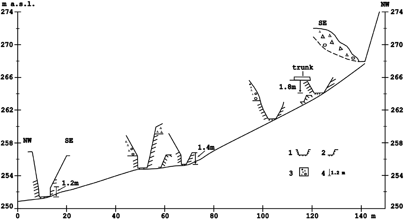
Fig. 7.
Longitudinal profile and cross-sections of the lower segment of the source-incised valley for debris-flow cone No. 1. 1 – valley cut into bedrock, 2 – bedrock steps, 3 – colluvial debris-clay cover, 4 – incision depth of the valley floor (in meters).
Upstream from the rocky channel, numerous landslides were observed on the valley slopes, with colluvial deposits descending into the channel and obstructing water flow during the flood event (Fig. 8). These landslides served as a source of material transported into the channel.
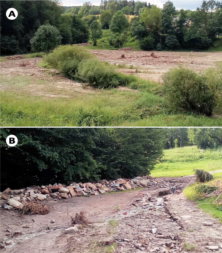
Fig. 8.
A – Overview of debris-flow cone No. 2. The central (mid fan) sector of the cone shows an accumulation of coarse debris lobe, whereas the marginal zones are composed of gravelly sandy sediments. B – The apex part of debris cone No. 2 with incised channel. Sandstone blocks and boulders, up to 90 cm in diameter, accumulated at the mouth of the forested V-shaped valley.
Debris cone and feeder V-shaped valley No. 2
Downstream of the bridge over the Stupnica River in Sufczyna, another debris cone was deposited (Fig. 1C), with a length of 96 m and an area of 0.55 ha (Fig. 8A, Tables 1 and 2). During the catastrophic debris flow event, the stream at the mouth of the incised valley abruptly shifted its locus of deposition due to channel avulsion. This resulted in straightening and a northward displacement of the stream channel over a 30-m stretch.
In the proximal and central sections of the cone – extending over approximately 60 m – deposition was dominated by coarse-grained material (maximum diameter of sandstone blocks reached 92 cm) (Table 1, Fig. 8B). Two convex, elongated debris ridges (levees), aligned with the long axis of the cone, were observed on its surface. These were composed of sandstone blocks with maximum diameters of 87 cm.
The cone’s sediment thickness was approximately 60 cm in the proximal zone, 40–50 cm in the central zone, and about 10 cm in the distal zone, at the boundary with the Stupnica floodplain. In proximity to the stream channel, flood deposits laid down by the Stupnica locally reached up to 37 cm in thickness. The total volume of debris material deposited on the cone, based on a surface area of 0.55 ha and an average thickness of 0.4 m, was estimated at approximately 2200 m3.
The incised valley has a total length of 1100 m (Table 2), a narrow floor (3–4 m wide) cut into sandstone and valley sides reaching 10–12 m in height. The valley is distinctly asymmetrical: the right slope is steep and rises to 20 m, while the left slope is gentler. Landslide processes have shaped both slopes (Fig. 1C).
Mud-debris cone and feeder valley No. 3
The shape of this cone was irregular: the northern side was 50 m long, while the southern side was shorter (28 m); along its axial line, the cone measured 47 m in length (Table 2). Its longitudinal profile showed three zones: (1) an erosion zone 20–25 m in length with shallow rills (erosional grooves) incised into bedrock, (2) a transport zone, and (3) a depositional zone, variable in both thickness and grain size. In the proximal (apex) part of the cone, the largest sandstone boulders reached diameters of 40–50 cm, and fine mudstone clasts reached 20–30 cm. The cone also hosted abundant tree branches, logs and woody debris. Sediment thickness varied, with the thickest layer (30–40 cm) in the proximal part and the thinnest at the margins, where fine mudstone clasts and soil aggregates (sand-sized) predominated. The estimated volume of deposited material on the cone was approximately 440 m3.
The valley from which the rocky material was transported is only 400 m long. In its lower part, over a distance of about 100 m, it forms a broad erosional gully or a slope trough (German Dellen) with a shallow incised channel (depth 0.4–0.5 m). During the flash flood, water flowed across a width of 6–7 m and carved a shallow channel into weathered shales and mudstones. A debris jam formed of woody and rocky material caused localised water ponding. The valley cuts through extensive, old landslides covering the left bank of the Stupnica valley. Similar small valleys with mud-debris accumulation have been mapped to the south of the described cone.
Fan delta and feeder valley No. 4
The greatest sediment thicknesses (approx. 1 m) were recorded on the fan deposited at the mouth of a small incised valley (a right-bank tributary of the Korzonka stream) in Korzeniec (Figs 1B and 9). The fan was accumulated on the right-bank terrace, 2–3 m above the channel level (290.3 m a.s.l.). Its dimensions are small: 28–30 m in length and 16 m in basal width (Table 1). The surface of the fan was flat, with a slight inclination toward the axis of the valley. These measurements do not include the portion of the fan deposited between buildings, which was not accessible for investigation.
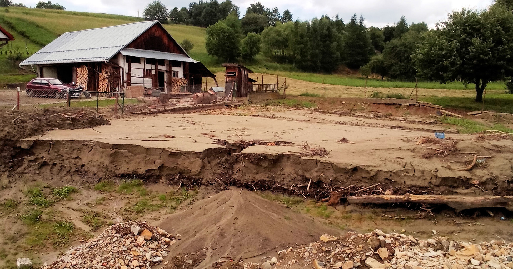
Fig. 9.
Delta fan deposits, up to 1 m thick, accumulated in a small valley (a tributary of the Korzonka stream) during the peak of a flood wave backed up by a road embankment and a tree jam blocking the road culvert.
The description of the exposure in the southern part of the fan near the stream channel includes (from top to bottom):
– 0.00–0.18 m – silt-sandy layer with fragments of twigs and fine plant detritus,
– 0.18–0.25 m – sand with fragments of small wood pieces,
– 0.25–0.67 m – coarse– to medium-grained sand at the top, grading into finer sand toward the base,
– 0.67–0.77 m – sandy silt with fragments of small wood,
– 0.77–1.07 m – plant detritus: leaves, wood fragments, branches, small and large tree trunks,
– 1.07–1.10 m – soil layer.
In the eastern (proximal) part of the fan, the sediment thickness was small, as documented in a second exposure. The profile from the top includes:
– 0.00–0.15 m – plant detritus (sticks, leaves, bark) in silty sand,
– 0.15–0.35 m – fine– to medium-grained sand with organic matter,
– 0.35–0.45 m – clayey silt (soil layer).
The described landform is a fan delta, formed due to the obstruction of water flow by a road embankment and the clogging of a culvert by a debris jam of trees and stones. Under these conditions, a temporary flow-through pond formed, collecting water flowing from the upper part of the valley. As a result, water flooded buildings located downstream from the fan and partially overflowed the road embankment (294.6 m a.s.l.), which lies 4 m above the streambed. After the culvert was cleared by firefighters several hours after it had become blocked, the rapidly flowing water incised the fan, forming erosional gullies (crevasses), and at their mouths, small depositional cones (splays) developed. Water that had previously ponded, when released through the culvert, eroded the downstream channel segment with high energy (Fig. 2). The volume of material deposited within the studied portion of the fan (surface area 500 m2) is estimated at approximately 400 m3.
The valley, at the outlet of which the fan was deposited, is the largest of those discussed so far – 3.5 km in length with a catchment area of 2.88 km2 and a slope gradient of <5% (Table 2). The valley has a bedrock-alluvial floor with gravel bars deposited during the flood event, accompanied by bank undercutting (see Fig. 2). At the junctions of the main valley and side incised valleys, small gravel fans were deposited during the flood, measuring 12 m in length, 9 m in width and up to 1 m in thickness (Fig. 2). The maximum diameter of boulders deposited on the fan was 30 cm.
Discussion
The above examples demonstrate that in the Foothill region of the Carpathians, similarly to valleys in the Beskid Mountains, the morphological effects of extreme hydrometeorological events are comparable. Heavy rainfall and catastrophic flash floods, occurring every few years, often play a decisive role in shaping valley floors and hillslopes in foothill areas.
Geomorphological results of flash floods
Extreme rainfall on 26 June 2020 triggered rapid surface runoff and mobilisation of large volumes of clastic material within the floors of V-shaped valleys. The dense, highly saturated debris–mud flows, characterised by high viscosity, were capable of transporting sandstone blocks up to 90 cm in diameter. The transported material, carried within a water–mud matrix, incised the rocky valley floors and undercut valley slopes. Erosion and undercutting of the valley sides were most pronounced in the lower sections of the valleys, while in their upper parts, valley floors were buried beneath colluvial deposits of shallow landslides (Figs 6A and 7). Temporary retention of runoff within valley floors was likely caused by colluvial dams and accumulations of debris wood. Sudden drainage of such a reservoir could generate a surge wave characterized by high peak discharge and rapid current dynamics (Pierson 1980, Teisseyre 1994). The valleys were deepened by approximately 1.0–1.5 m, locally up to 1.8 m.
At the mouths of the valleys, three types of depositional landforms were observed: (1) debris cones, (2) debris–mud cones, and (3) fan deltas. The debris cones, composed of coarse-grained clastic material (blocks and boulders) and woody detritus (tree trunks, branches), had the largest surface area and thickness (see Figs 6A and 8, Tables 1 and 2). Smaller debris–mud cones were built mainly of fine–grained sediments, including mud aggregates (soil-derived sands), with a lower proportion of coarse clastic debris. The term fan delta is used here following its geomorphological definition, referring to an alluvial fan that progrades directly into a standing or slow-flowing body of water, forming a subaerial–subaqueous depositional complex (McPherson et al. 1987). The fan delta at the mouth of the tributary of the Korzonka stream, composed of sandy-muddy deposits (see Fig. 9), formed where water flow was temporarily blocked by a road embankment and a culvert clogged with vegetation. The largest debris cone covered an area of approximately 0.5 ha, with an estimated volume of 2200 m3 of deposited material (see Fig. 8A, Table 1). Whereas the smallest landform – the fan delta – had a surface area of 0.05 ha and accumulated about 400 m3 of material (see Fig. 9, Table 1).
While the first two types of cones correspond to turbulent debris–mud flows described by Ziętara (1999) and are typical for outlets of V-shaped valleys in middle mountains, the third type identified here, a fan delta, is rarely mentioned in the literature in the context of mountainous areas.
According to Van Dine’s (1985) classification of debris flows – based on material type, transport mechanism, geomorphic setting, and water content – the first two types of landforms correspond to processes defined as debris torrents (i.e. channelised debris flows). Hence, the resulting accumulations are here referred to as debris (torrent) cones.
In contrast, the effect of flow observed after the rainfall of 21–22 June in a forested ravine near Rzeszów in the Dynów Foothills (see Fig. 5) contained a high proportion of fine material mixed with wood debris. Following Van Dine’s (1985) typology, the event is classified as a mudflow rather than a typical debris torrent, and it produced a smaller, less distinct depositional form.
The type and grain size of material deposited in the cones within the Stupnica valley show a clear relationship with the geological structure of the source catchments, as identified during field observations (Fig. 1C). Small gullies and trough valleys incised primarily into shale–mudstone complexes supplied fine-grained muddy material (rounded clasts, soil aggregates) with limited amounts of sandstone debris. However, larger incised (V-shaped) valleys (0.5–1.5 km long) dissecting medium- and fine-bedded sandstone complexes (see Figs 1C, 6B, and 7) delivered coarse rock debris, including sandstone blocks up to 90 cm in diameter. This geological variability on the left-bank tributaries of the Stupnica valley, which strongly influences valley morphology and fan structure, is well illustrated in geological maps and cross-sections (Kotlarczyk 1988, Rauch et al. 2009, Zuchiewicz, Zasadni 2010).
In valleys without direct hydrological connection to the Stupnica, all transported material was deposited in debris cones at the foot of steep erosional scarps (Fig. 1C). In the case of small tributary valleys discharging directly into the main valley (e.g., the Korzonka stream), small gravel fans were formed at their mouths (Fig. 2). Under conditions of limited flood conveyance capacity, caused by road embankments or vegetative jams, fan deltas may form in valley outlet zones.
Meteorological aspects: Rainfall thresholds initiating debris flow
It is very difficult to define rainfall threshold values that initiate debris flows leading to the formation of torrent cones. The cones formed on 26 June 2020 were associated with rainfall intensities ranging from 20 mm·h−1 to >40 mm·h−1, as recorded at the Bircza weather station located approximately 3–4 km from the study area (Fig. 3). Radar imagery of storm cells indicates that peak rainfall intensities within the storm core may have exceeded 100 mm·h−1 (Fig. 5).
Comparable rainfall events have triggered debris flows in other Carpathian regions. On 28 June 2018, a cloudburst over the Połonina Wetlińska (Bieszczady Mts.) resulted in 40 mm of precipitation within 1 h and initiated debris flows descending into the Prowcza stream valley (information from S. Kucharzyk, Bieszczady National Park; Gębica et al. 2019). Similarly, a downpour on 26 July 2005, over the headwaters of the San River (northern Bieszczady margin), with an intensity of 20 mm in just 10 min, triggered the accumulation of debris cones at the mouths of small gullies (observed by L. Starkel; Cebulak et al. 2008). In the Tatra Mountains, rainfall intensities of 35–40 mm·h−1 are sufficient to ‘mobilise entire debris slopes down to the valley floors’ (Kotarba 1992). Studies of debris-flow cones formed in September 2024 in the Silesian–Moravian Beskids in the Czech Republic also indicate that the most likely period of debris-flow occurrence took place during the peak of rainfall with intensities of up to 40 mm·h−1 (Panek et al. 2025).
However, not only the magnitude and intensity of rainfall influence slope and valley floor transformations. The geomorphic impact of flash floods also depends on the spatial distribution of storm precipitation within the catchment, as clearly shown by radar images of storm cells (Fig. 4).
For example, precipitation totals exceeding 70 mm on 11–12 April 2009, in the Stupnica valley, did not trigger any debris flows. This was likely due to the spatial pattern and trajectory of convective storm cells, with the heaviest rainfall confined to the upper part of the catchment. As a result, runoff was insufficient to initiate debris transport in the middle and lower valley sections, where unconsolidated slope material is typically mobilised. The resulting flood wave (2–3.5 m in height) caused significant erosional and depositional changes within the main valley floor (Gębica et al. 2019).
In contrast, during the 26 June 2020 event, the most intense rainfall occurred over an elongated area (15 km long, 5 km wide) between Bircza and the San River. More specifically, this included the watershed ridge and slopes of the left-bank section of the Stupnica valley and the Brzuska valley (see Fig. 4). Consequently, the most pronounced morphological changes were observed in the catchments of small streams and tributaries of the Stupnica River. A smaller storm cell (ca. 50 km2 in area) affected the western part of the Jawornik catchment and the San River valley east of Dynów (see Fig. 4). The spatial extent of this cell corresponds with the most intense erosion and sedimentation observed in valleys on the left-bank side of the Jawornik catchment (see Fig. 2). Similar observations linking radar-derived precipitation distribution and its geomorphic impacts have been made for the Beskid Wyspowy region (Pyrc 2023).
Prolonged, steady rainfall lasting several to over a dozen days can also significantly influence the occurrence of debris flows in valleys, as such conditions lead to saturation of soil and weathered material mantles (Pierson 1980, Armanini et al. 2005). Such antecedent rainfall occurred in the foothill valleys between 13 and 23 June 2020 (Fig. 3), promoting the activation of debris–clay mantles previously saturated with water.
Conclusions
The immediate cause of the formation of debris cones was the short-lived, high-intensity rainfall that occurred on 26 June, 2020. These events affected segments of small catchments (ranging from several tens to about 200 km2 in area) located within the middle San River basin. The catastrophic rainfall on that day caused flash floods and sudden stream surges, particularly in the Stupnica valley. The effects of this rainfall and flooding event in June 2020 were also observed in other small catchments within the Wisłoka and Wisłok river basins.
Torrent cones were formed by debris–mud flows in forested, V-shaped valleys with catchment areas <1.5 km2. These valleys are characterised by steep longitudinal gradients (>10%) and narrow bedrock-cut floors. Channel incision within these gullies reached depths of approximately 1.0–1.5 m.
Depending on the type, grain size and structural characteristics of the deposited material, three categories of cones can be distinguished: (1) small mud–debris cones composed primarily of fne colluvium and soil aggregates (mainly sand and silt) with minor gravel content, (2) larger debris cones containing sandstone blocks up to 90 cm in diameter and (3) fan delta composed predominantly of fne-grained (mud-sand) material deposited under subaqueous conditions as a result of temporary flow impoundment.
The formation of debris-flow (torrent) cones requires rainfall intensities of at least 40–50 mm·h−1 (daily totals around 80 mm), capable of initiating flows that mobilise entire hillslopes down to the valley floors. Such intense precipitation typically results from local convective storms or cloud-bursts. Consequently, the occurrence of torrential cones or debris flow deposits is usually restricted to isolated small valleys or even parts thereof, while adjacent valley sections – sometimes only a short distance from the storm centre – remain unaffected.
A comparison of two rainfall events that occurred in April 2009 and June 2020 in the Stupnica catchment demonstrates significant differences both in the spatial distribution of peak rainfall and the resulting flood impacts.
The antecedent (preparatory) period preceding the main rainfall event plays a crucial role in triggering debris–mud flows. In the case of the 26 June 2020 event, 11 days of rainfall before the storm led to saturation of surficial sediments, which facilitated the initiation of mass flows and the downslope transport of water-saturated debris in the gullies.
Acknowledgments
The field research was partially funded by the Institute of Archaeology of the University of Rzeszów. We would like to thank Dr. S. Superson for his assistance with fieldwork. We thank Reviewers for reviewing the paper and greatly contributing to its improvement.
Notes
[2] Contributed by Author contributions
P.G. – Conceptualization, geomorphological investigation, analysis, visualization; R.P. – Synoptic analysis, radar data analysis and visualization, cartography; D.K-L. – Synoptic analysis, processing and interpretation of measurement and radar data